面向农村土地确权的无人机航测系统分析及应用流程研究
2021-03-25李名哲
李名哲

摘 要:利用无人机航测技术生產土地调查工作底图具有实地调查不可比拟的优势。该文探讨了基于无人机航测的土地确权底图制作相关技术流程,论文首先分析了当前无人机航测的技术基础,进而探讨了适用于土地确权工作的底图制作的无人机航摄系统的性能要求,结果表明。利用无人机航测技术生产土地调查工作底图,不仅为核算外业界址点测量和权属调查工作量提供了重要依据,获取的农村地区影像亦能作为基础资料保存,必要时可将其作为新农村建设、村镇规划、应急测绘保障工作等的重要基础图件。
关键词:无人机 航测 土地确权 工作底图
中图分类号:P231 文献标识码:A文章编号:1672-3791(2021)01(c)-0015-04
Abstract: Using UAV aerial survey technology to produce land survey work base map has incomparable advantages in field survey. This paper discusses the relevant technical process of land ownership confirmation base map based on UAV aerial survey. Firstly, the paper analyzes the technical basis of UAV aerial survey, and then discusses the performance requirements of UAV aerial photography system suitable for land ownership confirmation. The results show that the production of land survey base map by using UAV aerial survey technology is not only for providing an important basis for the measurement of industrial sites outside the accounting and the workload of ownership investigation, but also the acquired images of rural areas can be stored as basic data, and it can be used as important basic maps for new rural construction, village and town planning, emergency surveying and mapping support work, etc.
Key Words: UAV; Aerial survey; Land ownership confirmation; Working base map
在农村土地承包经营权确权项目中,当地政府部门提供的地方影像图大都比例尺较小,详细程度不够,时效性不足,无法直接作为工作底图,常常需要重新生成正射影像图。
无人机测绘技术具有使用成本低、反应速度快、场地限制小、操作简便灵活的优势,已成为目前农村土地承包经营权确权登记工作中大比例尺影像图制作优先使用的测绘手段。该文以粤北山区某县农村土地承包经营权确权登记项目为例,探讨无人机测绘在农村土地承包经营权确权登记地图制作及后续权属调查中的应用。
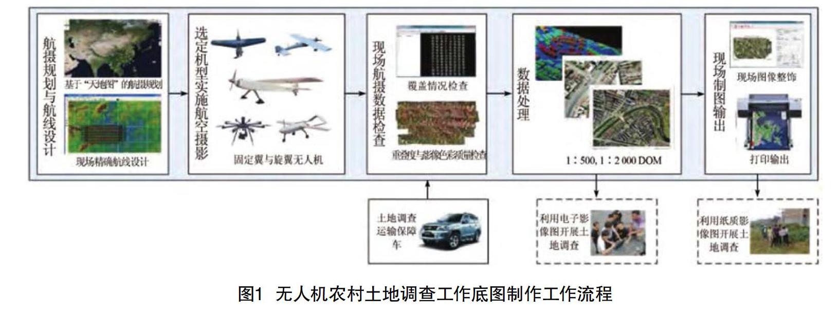
1 总体工作流程
接收土地调查无人机航摄指令后,基于“天地图”公众服务平台开展航摄规划,基于DEM开展精确航线设计。选定适合的无人机飞行平台开展航空摄影,获取航摄影像。……
