Changes of glacier area in the Xiying River Basin,East Qilian Mountain, China
2017-11-17YuShuoLiuXiangQinWenTaoDu
YuShuo Liu , Xiang Qin , WenTao Du
1. State Key Laboratory of Cryospheric Sciences, Northwest Institute of Eco-Environment and Resources, Chinese Academy of Sciences, Lanzhou, Gansu 730000, China
2. Qilian Shan Station of Glaciology and Ecologic Environment, Northwest Institute of Eco-Environment and Resources,Chinese Academy of Sciences, Lanzhou, Gansu 730000, China
Changes of glacier area in the Xiying River Basin,East Qilian Mountain, China
YuShuo Liu1,2*, Xiang Qin1,2, WenTao Du1,2
1. State Key Laboratory of Cryospheric Sciences, Northwest Institute of Eco-Environment and Resources, Chinese Academy of Sciences, Lanzhou, Gansu 730000, China
2. Qilian Shan Station of Glaciology and Ecologic Environment, Northwest Institute of Eco-Environment and Resources,Chinese Academy of Sciences, Lanzhou, Gansu 730000, China
The Xiying River, one of eight tributaries of the Shiyang River, located at Lenglongling, east Qilian Mountain, is formed by the confluence of Luotuo, Qingyang, Ningchan, and Shuiguan rivers. In the Xiying River Basin, where have 42 glaciers which toward NE in the majority. In this study, three Landsat images and two topographic maps were used to extract boundaries by artificial vector quantization. Results show that glacier area in Xiying Basin increased slightly around 1987,since then, has been reduced considerably. From 1956/1972 to 2008, glacier area in Xiying River Basin was reduced by 20.76%, nine glaciers have disappeared, and below 4,100 m a.s.l., there is no ice cover. Variation tendency of glacier retreat was obviously controlled by orientation. Temperature increase especially after 1987 is the main reason of glacier shrinkage, where glaciers in the Xiying River Basin are more sensitive to climate change.
glacier shrink; Qilian Mountain; Xiying River; remote sense
1 Introduction
The Shiyang River Basin located at the eastern Hexi corridor, western China, which include eight tributaries originating from East Qilian Mountains,from west to east, there are Xida, Dongda, Xiying,Jinta, Zamu, Huangyang, Gulang, and Dajing rivers.Precipitation, glacier and snow melt are the main water supply for Shiyang River. About 3.6% water supply comes from glacier melt, and groundwater of plain terrain comes from mountain runoff transformation (Zhang, 2006; Kang et al., 2009). For nearly half a century, with the development of industry and agriculture, in the middle and lower reaches of Shiyang River, the demand of water resources has increased.Because of over-extraction of groundwater and utilization, the contradiction of water demand between upstream and downstream has become very acute. Excessive exploitation of groundwater has led to serious ecology and environment problems (Ma et al., 2004;Shen et al., 2005).
In recent years, many scholars have studied climate, agricultural ecology, water resource and runoff change within the Shiyang River Basin (Lan and Kang, 2000; Lan et al., 2003; Kang et al., 2004; Liu,2006; Ma and Wei, 2006; Xu et al., 2007; Huang et al., 2008; Li et al., 2008; Liu et al., 2009). Under the influence of human activity and natural forces, contradiction between supply and demand of water resource is increasing substantially, especially at the two downstream oases of Wuwei and Minqin. Due to climate change, obvious runoff reduction of Shiyang River is more than three other inland river basins in Hexi area. In addition, accounting for 88% to 92% of incoming water and groundwater are impounded and exploited at Liangzhou oasis located in the middle and lower reaches of Shiyang River, where rivers and lakes have nearly dried up. Also, the excessive exploitation of groundwater in Minqin has caused the near collapse of the natural ecosystem of the entire oasis (Li and Xiao, 2005; Li et al., 2005; Ma and Wei,2008; Zhang et al., 2011; Zhong, 2011). As a "solid reservoir", river runoff can be regulated by glacier mass balance, and researches have pointed out that when glacier coverage in the basin is more than 5%,effect of river regulation is obvious. When glacier coverage is more than 10%, river runoff is basically stable (Ye et al., 1999, 2012). Related simulation studies also point out, under the background of rising temperatures, change rate of glacier volume is greater than length and area, and runoff of small glaciers are more sensitive to climate change (Ye et al., 2003,2005). Thus, glacier observation at upper Shiyang River is very important. In this study, based on topographic maps and remote sensing data, combined with nearby meteorological station data, variation of glaciers and climatic background of the Xiying River Basin was analyzed from 1956/1972 to 2008. This study provides a scientific basis to analysis the current situation and changes of water resources.
2 Study area
The Xiying River located in Lenglongling area,East Qilian Mountain, China, is one of eight tributaries of the Shiyang River (Figure 1). Runoff of Xiying River is 38% of Shiyang River (Liu et al., 2013a).The Xiying River Basin include 4 sub-stream basins,there are Shuiguan River (Basin No. 5Y416G),Ningchan River (Basin No. 5Y416F), Qingyang River(Basin No. 5Y416E) and Luotuo River (Basin No. 5Y416D). There are 42 glaciers in the Xiying River Basin, 15 are towards the North-East (NE), 10 are towards the North (N), 6 are towards the South-West (SW),and 1 towards the West (W) (Figure 2). Thirty-five glaciers are less than 1 km2, and seven are 1~4 km2(Wang et al., 1981). The upstream region of Shiyang River is mainly affected by summer monsoon, with increased precipitation on the windward side. Characteristics of glacier mass circulation is high accumulation and strong ablation, glaciers in this region are sensitive to climate change, and water recharge rate of glacial melt is about 7%~15% (Shen et al., 2001). In the Xiying River Basin, average precipitation is about 800 mm (Gao and Yang, 1985), and average snow line which is the lowest in the Qilian Mountains is about 4,450 m a.s.l. (Yang, 1991). Previous observations noted that the distribution of annual precipitation is very uneven, precipitation in second half year accounts for more than 80%, 60% of which appears in Jun–Aug. Precipitation in September to November is usually more than March to May, with day-time precipitation more than night-time in mountainous areas.At present, systematic research and observations have been carried out at Ningchan River Glacier No. 3 and Shuiguan River No. 4 (Li et al., 2010; Liu et al.,2013c).
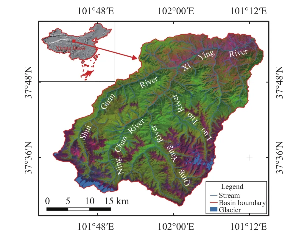
Figure 1 Map of Xiying River Basin (Base map with ETM+,R: Band 5; G: Band 4; B: Band 3)
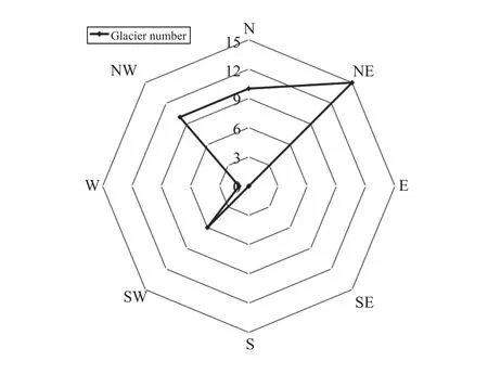
Figure 2 Distribution of glaciers direction in Xiying River Basin
3 Data and methods
In this study, two topographic maps have been used. One is an annotated aerial photograph acquired in 1956, which includes the Shuiguan and Ningchan river basins. The second is an annotated aerial photograph acquired in 1972, which includes the Luotuo and Qingyang river basins. Three Landsat images have been used, there are TM (acquired in 1987-9-9 and 1995-6-11), and ETM+ (acquired in 2008-8-9).All the remote sensing images and topographic maps have been corrected to UTM coordinates. The image registration error is less than half a pixel. Color-composite images are composed by three bands of TM image (5, 4, 3). Researchers used artificial vector quantization to extract glacier boundaries (Figure 3). When the slope is less than 25°, the error of 1:50,000 topographic is less than 11 m, when the slope is greater than 25°, the error is less than 19 m (State Bureau of Surveying and Mapping, 2007). In this study, we compared field surveying data with Landsat image data, the error of artificial vector quantization from Landsat image is about 1.83% (Liu et al., 2013b),which is acceptable in this study.
4 Results
Table 1 shows changes in glacier area of Xiying Basin. From 1956/1972 to 1987, the total area of 42 glaciers increased about 5.3%; from 1987 to 1995,glacier area reduced by 12.66% (1.58% per year on average), and one glacier disappeared (Table 2); from 1995 to 2008, total glacier area reduced by 14.97%(1.15% per year on average), and eight glaciers disappeared (Table 2).
In 1956/1972 to 1987, there was a small increase in glacier area of 10.14% (0.68% per year on average)in the Ningchan River Basin, and by about 2% (0.07%per year on average) in Luotuo and Qingyang river basins. Since 1987, retreating of glaciers area in the Luotuo River Basin has accelerated, but in other basins, the retreating trend has weakened to some extent.
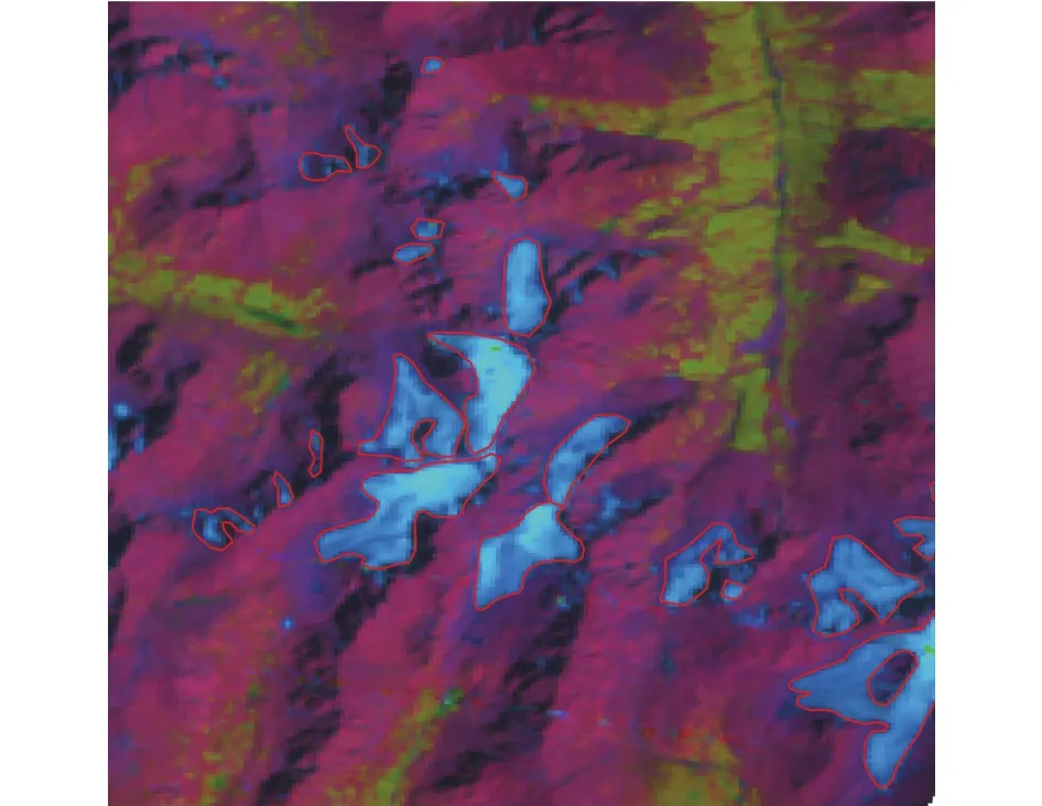
Figure 3 Extract glacier boundary by artificial vector quantization
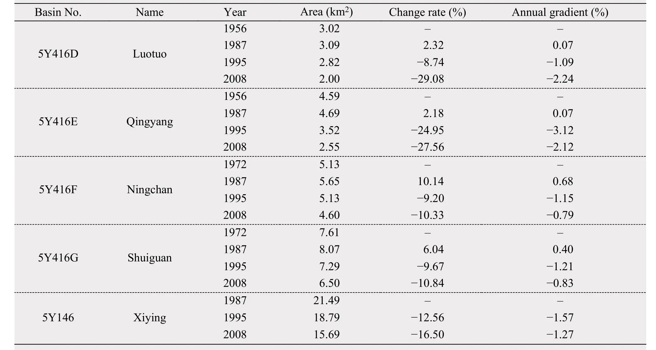
Table 1 Glacier change in Xiying River Basin
Statistics of glacier area changes on altitude zone based on 1956/1972 contour lines shows, from 1956/1972 to 2008, ice cover had already disappeared at 4,000~4,100 m a.s.l.. and decreased by 62%at 4,100~4,200 m a.s.l.. Shrink tendency of ice area is weakening with increasing altitude. At the glacier top(4,800~4,900 m a.s.l.), there is also a certain amount of shrinkage (Figure 4). Statistics on annual variation rate of glaciers with different direction shows reduction in the NE is the fastest and SW is faster(Figure 5).
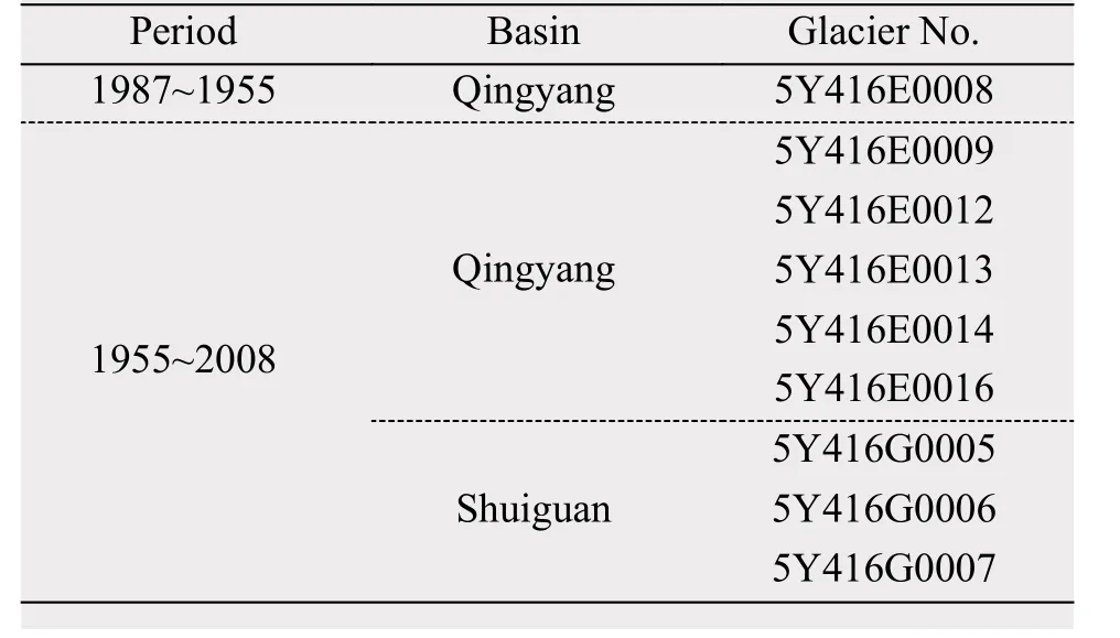
Table 2 Glaciers disappeared from 1987 to 2008
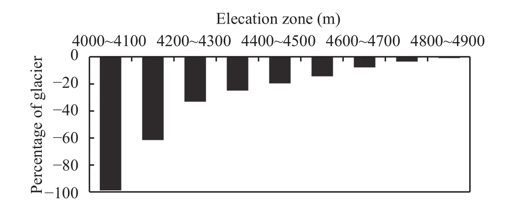
Figure 4 Variation of glacier in different elevation zones,from 1956/1972 to 2008
In 1956~1976, the terminal retreat and area reduction of Shuiguan River glacier No. 4 (Glacier No. 5Y416G4) are 320 m and 0.97% per year respectively; in 1976~1984, 69.7 m and 0.12% respectively;in 1972~2007, 225 m and 0.04 km2respectively, and at the ablation zone, there is constantly ice thinning(Li et al., 2010). Since 1972, the terminal retreat, area reduce and volume decrease of Ningchan River Glacier No. 3 (Glacier No. 5Y416F3) are 6%, 13.1% and 35.3%, respectively, and glacier with progressive thinning (Liu et al., 2013c). Variation tendency of those two glaciers are the same at a basin scale.
5 Discussion
Some studies have pointed out that the temperature increase especially in summer is a decisive reason for ice melting (Shi, 2001). Using temperature and precipitation data at Menyuan and Wushaoling meteorological stations (Figure 6), the rates of temperature and precipitation change were calculated. We found average summer temperatures of Menyuan and Wushaoling have increased by 0.03 °C and 0.02 °C respectively, the rates of annual average temperature at these two locations are same as the rates of average summer temperature, and precipitation of Menyuan and Wushaoling have decreased by 0.4 mm and increased slightly, respectively.
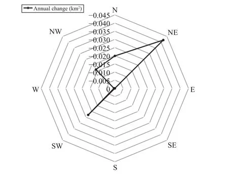
Figure 5 Changes in glaciers of different direction
From 1956/1972 to 2008, reduction of glacier area is 20.76%, which is more than other regions, e.g., reduction of Glacier No. 12 in Laohugou Valley located in west Qilian Mountain is lower than Ningchan River Glacier No. 3, Shuiguan River No. 4 is 4% in 1958~2009 (Liu et al., 2011; Liu et al., 2013c),Tuotuo River Basin is 3.2% in the late 1960s (Zhang et al., 2008), western Nyainqentanglha Range is 6.1%±3% between 1976 and 2001 (Shangguan et al.,2008; Bolch et al., 2010) and Gongga Mountain region is 11.3% from 1966 to 2009 (Pan et al., 2011). In recent decades, glaciers in the Xiying River Basin are shrinking seriously. Hence, glaciers in the Xiying River Basin are very sensitive to climate change.
6 Conclusions
From 1956/1972 to 2008, in the Xiying River Basin, glacier area reduced by 20.76%, but increased slightly around 1987, nine glaciers have disappeared,and reduction tendency of glaciers are accelerating.Because of glacier shrinkage, there is no ice cover below 4,100 m a.s.l.. Retreat rate of glaciers is obviously controlled by glacier orientation. Temperature increase especially after 1987 is the main reason for glacier shrinkage. Glaciers in the Xiying River Basin are very sensitive to climate change. In this study,Landsat TM/ETM+ is the data source used to extract glacier boundary, cloud and snow cover are critical factor of image interpretation. Thus, other observation method is needed in further work.
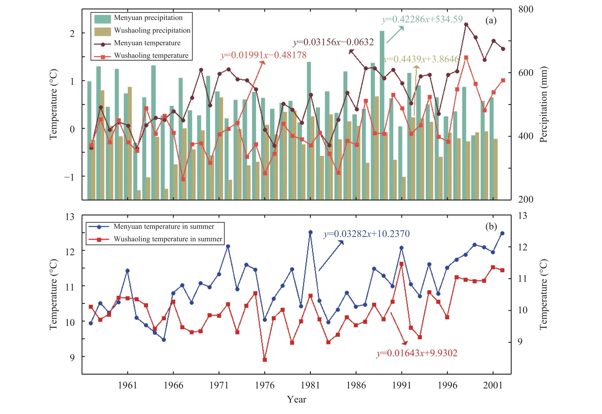
Figure 6 Annual temperature, average summer temperature and precipitation of Menyuan and Wushaoling
Acknowledgments:
This study was supported by the Project from the National Foundational Scientific and Technological Work Programs of the Ministry of Science and Technology of China (Grant No. 2013FY111400), the State Key Laboratory of Cryospheric Sciences(SKLCS-ZZ-2017), the Global Change Research Program of China (2013CBA01801), the Chinese Academy of Sciences (KJZD-EW-G03-01) and the National Natural Science Foundation of China(41371091), we also thank Junli Xu provide the Coordinate system conversion system v1.0(2016SR394422).
Bolch T, Yao T, Kang S, et al., 2010. A glacier inventory for the western Nyainqentanglha Range and the Nam Co Basin, Tibet, and glacier changes 1976–2009. The Cryosphere, 4(3): 419–433. DOI:10.5194/tc-4-419-2010.
Gao QZ, Yang XY, 1985. The features of interior rivers and feeding of glacier meltwater in the Hexi region, Gansu Province. In: Memoirs of Lanzhou Institute of Glaciology and Geocryology, Chinese Academy of Sciences, No.5 (Recent Fluctuations of Glaciers in the Qilian Mts). Beijing: Science Press, pp. 131–141.
Huang YX, Wang BJ, Zhang Q, et al., 2008. The impact and assessment of climate change and human activities on the water resources of Shiyang River Basin. Plateau Meteorology, 27(4):866–872.
Kang ES, Li X, Zhang JS, et al., 2004. Water resources relating to desertificationin the Hexi Area of Gansu Province, China. Journal of Glaciology and Geocryology, 26(6): 657–667. DOI:10.3969/j.issn.1000-0240.2004.06.001.
Kang SZ, Su XL, Du TS, et al., 2009. Water resources conversion law and water conservation control mode on basin scale in Northwest Arid Regions: an application in Shiyang River Basin in Gansu Province. Beijing: China Water Power Press.
Lan YC, Kang ES, 2000. Changing trend and features of the runoff from mountain areas of some main rivers in the Hexi Inland Region. Journal of Glaciology and Geocryology, 22(2): 147–152.DOI: 10.3969/j.issn.1000-0240.2000.02.008.
Lan YC, Ding YJ, Shen YP, et al., 2003. Responding of river streamflow to the climate shift in the Hexi Inland Region. Journal of Glaciology and Geocryology, 25(2): 188–192. DOI: 10.3969/j.issn.1000-0240.2003.02.013.
Li J, Liu SY, Shangguan DH, et al., 2010. Identification of ice elevation change of the Shuiguan River No. 4 glacier in the Qilian Mountains, China. Journal of Mountain Science, 7(4): 375–379.DOI: 10.1007/s11629-010-1124-1.
Li LP, Yang YL, Qian L, 2008. Analysis on the characteristics of temperature and precipitation in the Shiyang River Basin since recent 45 years. Arid Zone Research, 25(5): 705–710.
Li XY, Song DM, Xiao DN, 2005. The variability of groundwater mineralization in Minqin Oasis. Acta Geographica Sinica, 60(2):319–327. DOI: 10.11821/xb200502015.
Li XY, Xiao DN, 2005. Dynamics of water resources and land use in oases in middle and lower reaches of Shiyang River Watershed,Northwest China. Advances in Water Science, 16(5): 643–648.DOI: 10.3321/j.issn:1001-6791.2005.05.005.
Liu MC, 2006. Analysis and assessment of climatic dry and wet conditions in Shiyang River Basin. Chinese Journal of Ecology, 25(8):880–884.
Liu MC, Zhang Q, Deng ZY, et al., 2009. Influence of climate warming to agricultural production in Hexi Corridor-a case study in Shiyang River Basin. Scientia Geographica Sinica, 29(5): 727–732.
Liu MC, Li LP, Shi ZJ, et al., 2013. Distribution characteristics of runoff in Shiyang River basin and its responses to climate change-the case study of Xiying River. Agricultural Research in the Arid Areas, 31(1): 193–198. DOI: 10.3969/j.issn.1000-7601.2013.01.036.
Liu YS, Qin X, Du WT, et al., 2011. The movement features analysis of Laohugou Glacier No. 12 in Qilian Mountains. Sciences in Cold and Arid Regions, 3(2): 119–123. DOI: 10.3724/SP.J.1226.2011.00119.
Liu YS, Qin X, Gao SR, et al., 2013. Accuracy evaluation of glacier area information extracted from Landsat-5 TM remote sensing image. Journal of Northwest A & F University (Nat. Sci. Ed.), 41(12):209–219. DOI: 10.13207/j.cnki.jnwafu.2013.12.073.
Liu YS, Qin X, Zhang T, et al., 1226. The change of Ningchan River Glacier No.3 at Lenglongling, East Qilian Mountain, China. Sciences in Cold and Arid Regions, 5(6): 709–714. DOI:10.3724/SP.J.1226.2013.00709.
Ma L, Wei XM, 2006. Analysis on aberrance point of annual runoff serials in the downstream of Shiyang River. Agricultural Research in the Arid Areas, 24(2): 174–177. DOI: 10.3321/j.issn:1000-7601.2006.02.038.
Ma L, Wei XM, 2008. Time-series simulation of groundwater level in Minqin County of the Downstream Shiyang River. Journal of Irrigation and Drainage, 27(4): 89–91.
Ma QL, Sun K, Wang JH, 2004. Environment problem with Shiyang River Basin, its root-causes and rehabilitation measures. Journal of Safety and Environment, 4(5): 64–68. DOI: 10.3969/j.issn.1009-6094.2004.05.016.
Pan B, Zhang G, Wang J et al., 2011. Glacier changes from 1966–2009 in the Gongga Mountains, on the south-eastern margin of the Qinghai-Tibetan Plateau and their climatic forcing. The Cryosphere Discussions, 5(6): 3479–3516. DOI: 10.5194/tcd-5-3479-2011.
Shangguan DH, Liu SY, Ding LF, et al., 2008. Variation of glaciers in the western Nyainqȇntanglha Range of Tibetan Plateau during 1970–2000. Journal of Glaciology and Geocryology, 30(2):204–210.
Shen DJ, Cui LJ, Jiang SM, 2005. Institutional causes and countermeasures for water problems in Shiyang River Basin. Journal of Natural Resources, 20(2): 293–299. DOI: 10.11849/zrzyxb.2005.02.019.
Shen YP, Liu SY, Zhen LL, et al., 2001. Fluctuations of glacier mass balance in watersheds of Qilian Mountain and their impact on water resources of Hexi Region. Journal of Glaciology and Geocryology, 23(3): 244–250. DOI: 10.3969/j.issn.1000-0240.2001.03.006.
Shi YF, 2001. Estimation of the water resources affected by climatic warming and glacier shrinkage before 2050 in West China. Journal of Glaciology and Geocryology, 23(4): 333–341. DOI:10.3969/j.issn.1000-0240.2001.04.001.
State Bureau of Surveying and Mapping, 2007. CH/T 1015.4-2007 Technical rules for producing digital products of 1:10000 1:50000 fundamental geographic information Part 1: digital line graphs.Beijing: Surveying and Mapping Press.
Wang ZT, Liu CH, You GX, et al., 1981. Glacier Inventory of China,I: Qilian Mountain. Lanzhou: Lanzhou Institute of Glaciaology and Cryopedology.
Xu ZX, Li ZL, Shi XK, 2007. Long-Term trends of major climatic variables and runoff in the Shiyang River Basin. Resources Science, 29(5): 121–128. DOI: 10.3321/j.issn:1007-7588.2007.05.018.
Yang ZN, 1991. Glacier Water Resources in China. Lanzhou: Gansu Science and Technology Press, pp. 46.
Ye BS, Han TD, Ding YJ, 1999. Some changing characteristics of glacier streamflow in Northwest China. Journal of Glaciology and Geocryology, 21(1): 54–58.
Ye BS, Ding YJ, Liu FJ, et al., 2003. Responses of various-sized alpine glaciers and runoff to climatic change. Journal of Glaciology, 49(164): 1–7. DOI: 10.3189/172756503781830999.
Ye BS, Yang DQ, Jiao KQ, et al., 2005. The Urumqi River source glacier No.1, Tianshan, China: changes over the past 45 years. Geophysical Research Letters, 32(21): L21504. DOI: 10.1029/2005GL024178.
Ye BS, Ding YJ, Jiao KQ, et al., 2012. The response of river discharge to climate warming in cold region over China. Quaternary Sciences, 32(1): 103–110. DOI: 10.3969/j.issn.1001-7410.2012.01.11.
Zhang RL, 2006. The characters of distribution and transformation of water resources in Shiyang River Basin. Beijing: China University of Geosciences.
Zhang XM, Wang JD, Cheng YF, 2011. Diversity and landscape pattern analysis of Shiyang River upstream in Qilian mountains. Yellow River, 33(6): 76–77, 80. DOI: 10.3969/j.issn.1000-1379.2011.06.031.
Zhang Y, Liu SY, Xu JL, et al., 2008. Glacier change and glacier runoff variation in the Tuotuo River Basin, the source region of Yangtze River in western China. Environmental Geology, 56(1):59–68. DOI: 10.1007/s00254-007-1139-2.
Zhong XL, 2011. The runoff characteristics analysis of Shiyang River Basin. Gansu Water Conservancy and Hydropower Technology,47(4): 8–10.
*Correspondence to: YuShuo Liu, Northwest Institute of Eco-Environment and Resources, Chinese Academy of Sciences.No. 320, West Donggang Road, Lanzhou, Gansu 730000, China. Tel: +86-931-4967327; E-mail: yushuo_liu@lzb.ac.cn Citation: Liu YS, Qin X, Du WT, 2017. Changes of glacier area in the Xiying River Basin, East Qilian Mountain, China. Sciences in Cold and Arid Regions, 9(5): 432–437.
10.3724/SP.J.1226.2017.00432.
January 21, 2017 Accepted: May 6, 2017
杂志排行
Sciences in Cold and Arid Regions的其它文章
- The temporal and spatial variation of positive degree-day factors on the Koxkar Glacier over the south slope of the Tianshan Mountains, China, from 2005 to 2010
- A mathematical approach to evaluate maximum frost heave of unsaturated silty clay
- Characteristics of thawed interlayer and its effect on settlement beneath embankment in permafrost regions-A case study for the Qinghai-Tibet Highway
- Chemistry and environmental significance of aerosols collected in the eastern Tianshan
- Contamination and risk assessment of heavy metals in farmland soils of Baghrash County, Xinjiang,Northwest China
- Complex network analysis of climate change in the Tarim River Basin, Northwest China