贵州某市地理国情与国土调查数据的整合试验研究
2021-07-23刘婵娟
刘婵娟
摘要:厘清“国土三调”中“工作分类”与地理国情监测中“内容与指标”之间的关系,重新定义地理国情监测的分类体系,对开展自然资源调查监测工作至关重要。本文从地理国情监测在自然资源调查监测的应用出发,通过对地理国情监测数据与国土调查数据进行对比分析,从理论层面构建两种分类体系的对应关系,再从实践层面进行数据整合试验并分析差异原因,最后提出衔接国土资源等自然资源调查的地理国情优化建议。
关键词:地理国情监测 国土调查 数据整合 试验
Experimental Study on the Integration of Geographical Conditions and Land Survey Data of a City in Guizhou Province
LIU Chanjuan
(Guizhou Qianmei Institute of Surveying and Mapping, Guiyang, Guizhou Province, 550000 China)
Abstract: It is very important to clarify the relationship between the "work classification" in the "three land adjustment" and the "content and index" in the geographical national condition monitoring, and redefine the classification system of geographical national condition monitoring, so as to carry out the investigation and monitoring of natural resources. Starting from the application of geographical national condition monitoring in the investigation and monitoring of natural resources, this paper analyzes the geographical national condition monitoring data and the land survey data Finally, the paper puts forward some suggestions on the optimization of geographical conditions to link up the land resources and other natural resources survey.
Key Words: Geographic condition monitoring; Land survey; Data integration; Experiment
1 數据来源与研究方法
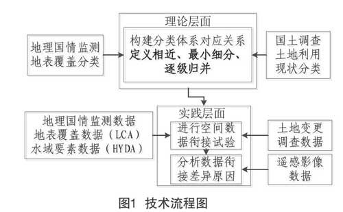
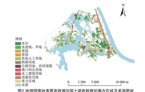
本文选取贵州某市城乡结合部区域为试验对象,试验区内建设用地与农用地、未利用地等非建设用地的面积比约为1∶1,包含一定规模的镇、乡和村庄建设用地,除盐碱地表、沙质地表等个别地类缺失外,其余地类均有涉及,两类数据反映出较为复杂的城乡用地情况,对于两类数据的对比分析具有典型代表性[1]。由于试验区内水体资源丰富多样,但反映常水位水面的地表覆盖分类中水域数据较为粗糙且缺失明显,而地理国情要素中水域要素不仅反映高水位水面且相对细致全面,故采用地理国情要素中水域要素数据与国土调查数据进行对比试验。在两类数据衔接试验后,采用2019年高分辨率遥感影像进行检验核查,分析两类数据的一致性以及造成数据差异的原因。本文研究方法的技术流程如图1所示。
1.1 构建分类体系……