陇南市农村居民点的空间格局差异研究
2020-08-06李艳玫
李艳玫
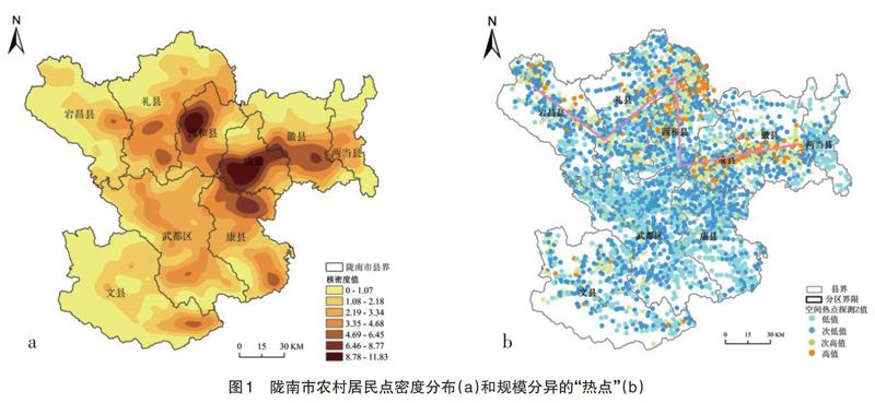

摘 要:基于GIS空间分析和景观生态学理论,定量分析了陇南市农村居民点空间分布格局特征。结果表明:(1)陇南市农村居民点聚落空间分布较分散,以成县中部地区为中心向四周呈阶梯状分散分布;(2)陇南市农村居民点整体规模分布普遍偏小,形成以西和县西为冠顶、宕昌县和成县为帽檐的“王冠”状结构;(3)全市农村居民点聚落形态整体相对规则、整齐,破碎化程度较低,局部地区居民点分布形态复杂程度较高,南北和东西走向规模分异明显。
关键词:农村居民点;景观生态学;空间格局;GIS;陇南市
中图分类号 C912.82;P208文献标识码 A文章编号 1007-7731(2020)14-0019-03
Abstract: Based on the GIS spatial and landscape ecology theory, quantitatively analyzes the spatial distribution pattern of rural settlements in Longnan. The results show that: (1) Overall, the spatial distribution of rural settlements in Longnan is relatively scattered, which forms a ladder-like distribution around the central area of Cheng County; (2) The distribution of rural residential areas in Longnan is generally small and skewed, it develops“Crown”-like structure: the west of Xiheis the top, Danchang and Chengxian are the brim of it. (3) The overall settlement pattern of rural settlements in the whole city is relatively regular, neat and fragile, while the distribution pattern of part residential areas in some areas is more complicated, showing the obvious scale differentiation of north-south and east-west direction.
Key words: Rural residential areas; Landscape ecology; Spatial pattern; GIS; Longnan city
農村居民点的分布是农村居民在自然环境中进行生产、生活、文化教育等活动过程中形成的[1],是乡村地理学关注的热点之一。国外对农村居民点的研究经历了起步、发展、计量变革、转型重构4个阶段,研究内容包括自然环境与居民点的关系、居民点形成过程、形态分布、演化及规划等方面,采用定量、定性综合分析的方法对涉及的人文地理学、社会学、生态学、经济学、环境学等领域进行研究[2-6]。国内对农村居民点的研究经历了初期、中期、快速、全面发展等阶段,主要包括居民点形态、规模、空间体系结构及其演变、影响因素、整理等方面[7-8]。刘纪远等[9]对近10年中国农村居民点空间分布进行研究得出,农村居民点的空间演变受经济和土地政策影响很大;邢谷锐[10]针对城市化进程中影响乡村聚落空间演变的因素进行了分析,并对其发展演变特征做了进一步分析总结。……
