河北省曲周县第四疃镇土壤养分状况及空间分布特征
2020-08-04张苏芮李一鸣
张苏芮 李一鸣
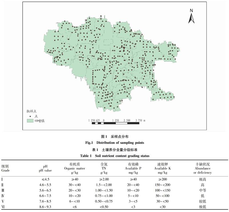
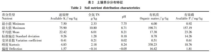
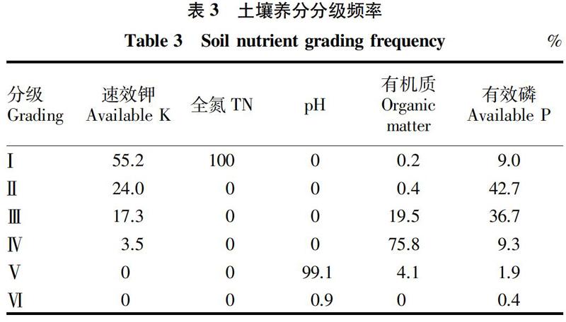
摘要 以河北省曲周县第四疃镇为研究区,采用网格化取样的方法,在四疃镇共采集506份土壤,利用SPSS相关分析和Arcgis空间插值的研究方法,研究土壤速效钾、有效磷、全氮、pH和有机质含量状况和空间分布特征。结果表明,研究区土壤偏碱性,土壤肥力中等偏上,速效钾、全氮、有效磷含量丰富,其中全氮含量均达到极高水平,有机质属于中等水平。养分空间分布呈现西部含量最高、东南部碱性最强的特征。
关键词 GIS;空间插值;养分分布
中图分类号 S153.6 文献标识码 A
文章编号 0517-6611(2020)14-0053-04
doi:10.3969/j.issn.0517-6611.2020.14.015
Abstract Taking Situan Town in Quzhou County, Hebei Province as the study area, using grid sampling method, a total of 506 soil samples were collected in Situan Town, using SPSS and Arcgis spatial interpolation research methods, soil available potassium, effective phosphorus, total nitrogen, pH and organic matter content and spatial distribution characteristics were studied. The results showed that soil in the study area was alkaline, soil fertility was moderate, available potassium, total nitrogen and available phosphorus content was abundant, among which the whole nitrogen content reached the extremely high level, and the organic matter belonged to the medium level. The nutrient spatial distribution shows the highest content in the west and the most alkaline in the southeast.
Key words GIS;Spatial interpolation;Nutrition distribution
土壤是一个连续的自然体,也是动植物生长生存、工业生产等重要的基础。土壤养分状况是土壤肥力的重要指标,也是科学施肥的依据[1]。土壤的成因不止受到气候、母质、生物、地形、时间等自然因素影响,同时还受耕作制度、施肥、种植工具等人为因素的影响。这就使得土壤具有高度的空间异质性,不管是在大尺度上还是小尺度上均存在[2]差异,这成为研究土壤养分的一个限制因子。因此研究一个地区的土壤养分含量状况和空间分布特征对于区域指导施肥、精准管理非常重要。同时,准确把握土壤中养分的空间分布规律是土壤资源管理科学决策的基础[3]。目前,对一个地区,县域的大尺度土壤养分空间分布研究众多,但针对一个镇域尺度的研究相对较少。海云瑞等[4]采用地统计学的方法对宁夏南部山区耕地土壤养分空间分布进行研究;胡明等[1]以潼关县为研究对象,采用地统计学的方法,土壤中有机质、pH、碱解氮、有效磷和速效钾的含量特征及其空间分布状况进行评价,并对其空间分布特征进行分析,为当地合理施肥、提高粮食产量提供依据。……
