青藏高原东北缘蒸散量时空分布特征
2019-10-21于永波王云鹏
于永波 王云鹏


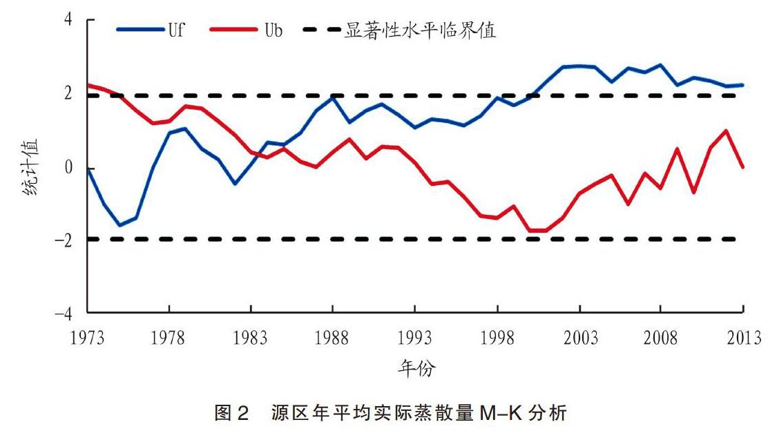
摘要 基于Penman-Moenteith模型、作物系数法及大型蒸渗仪资料(2012—2013年)计算1973—2013年青藏高原东北缘8个气象站逐日、逐月、多年年平均潜在蒸散量及实际蒸散量,利用时间趋势法、Mann-Kendall法、小波分析等方法对源区高原实际蒸散量时间变化特征进行分析,利用surfer制图软件、Kriging插值对源区实际蒸散量空间变化特征进行分析。结果表明,8站在全球逐渐变暖背景下总体呈现上升趋势,波动范围为9.94~21.93 mm/10年;逐月实际蒸散量具有明显的时间变化特征,近似正弦函数图像,其峰值出现在4—5月,低谷出现在10月,总体呈下降趋势;实际蒸散量具有明显的周期和突变变化特征;多年实际蒸散量空间分布呈现东南部相对高,西北地区较低,并且由前者到后者依次减少的趋势分布特征。
关键词 蒸散量;彭曼公式;作物系数;青藏高原东北缘;时空分析
中图分类号:P426.2 文献标识码:A 文章编号:2095-3305(2019)05-062-03
DOI: 10.19383/j.cnki.nyzhyj.2019.05.025
Spatial and Temporal Distribution Characteristics of Evapotranspiration in the Northeastern Margin of the Qinghai-Tibet Plateau
YU Yong-bo et al(Jiuquan Meteorological Bureau, Jiuquan, Gansu 735000)
Abstract Based on Penman-Moenteith model, crop coefficient method and large-scale transpirator data (2012-2013), the daily, monthly and multi-year average potential evapotranspiration and actual evapotranspiration of eight meteorological stations in the northeastern margin of the Qinghai-Tibet Plateau from 1973 to 2013 were calculated. The temporal variation characteristics of actual evapotranspiration in the source plateau was analyzed by time-trend method, Mann-Kendall method and wavelet analysis. The spatial variation characteristics of actual evapotranspiration in the source area was analyzed by using surfer mapping software and Kriging interpolation. The results showed that the actual evapotranspiration of eight meteorological stations showed an upward trend under the background of gradual global warming, and the range of fluctuation was 9.94-21.93 mm per 10 years. The monthly actual evapotranspiration had obvious time-varying characteristics. It was similar to the sinusoidal function image. Its peak value appeared in April-May, and its trough appeared in October. The overall trend was downward. The actual evapotranspiration had obvious periodic and catastrophic characteristics. The spatial distribution of actual evapotranspiration over the years was relatively high in the southeast and low in the northwest, and it decreased in turn from the southeast to the northwest.
Key words Evapotranspiration;Penman formula;Crop coefficient;Northeast margin of Qinghai-Tibet Plateau;Spatio-temporal analysis
地處于青藏高原东北边缘的甘南高原,因为地理位置特殊是黄河径流的主要汇集区和黄河上游至源头的重要水源涵养和补给区。黄河在甘南高原由南、东、北环绕而过,形成了“U”字形的第一弯,全境流程433 km,补给水量达黄河上游总水量的45%,是黄河的天然蓄水池,在维护黄河流域水资源和生态安全方面具有不可替代的作用。
近年来,由于自然和人为因素影响,青藏高原东北缘地区很多湿地和湖泊干涸,草原的生产性能和生态功能大幅下降,草地退化、沙漠化发展速度明显加快,蒸散发作为水循环与能量平衡间的桥梁,研究其时空变化特征将进一步揭示气候变化与生态环境变化间的内在关系[1]。……