基于GIS的低丘缓坡土地资源建设适宜性评价
2016-07-10尹一帆程燕芳沈俊林
尹一帆 程燕芳 沈俊林

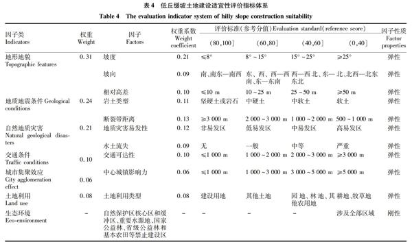
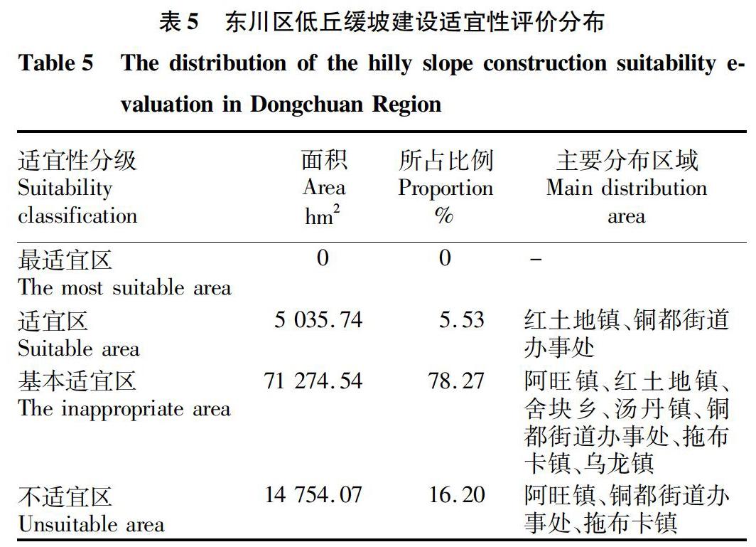
摘要 以云南省昆明市东川区低丘缓坡未利用地为例,在GIS的支持下,利用定性和定量分析相结合的方式,在充分考虑影响城镇建设各种因子的基础上选取参评因子,构建低丘缓坡建设适宜性评价因子体系,运用层次分析法确定各参评因子的权重,对低丘缓坡土地开发成建设用地的适宜性进行评价。结果表明,东川区内低丘缓坡土地开发为建设用地的最适宜区面积为0,适宜区为5 035.74 hm2,基本适宜区71 274.57 hm2,不适宜区有14 754.07 hm2。评价结果可为低丘缓坡荒滩等未利用地的建设开发提供依据,为优化城乡用地结构和综合开发未利用地提供技术支撑。
关键词 低丘缓坡;未利用地;建设适宜性;东川区
中图分类号 S127 文献标识码 A 文章编号 0517-6611(2016)05-228-03
Abstract Taking hilly slope unused land in Dongchuan Region, Kunming City, Yunnan Province as an example, under the support of GIS, using qualitative and quantitative combination way, selecting evaluation factors on the basis of fully considering each factor in urban construction, the evaluation indicator system for hilly slope land construction suitability was constructed, the weight was determined by AHP method. The results showed that the most suitable area, suitable area, inappropriate area and unsuitable area of hilly slope land in Dongchuan Region are 0, 5 035.74, 71 274.57, 14 754.07 hm2, respectively.The evaluation results canprovide the basis for development and construction of unused land, also provide technical support for optimizing urbanrural land structure and comprehensive development of unused land.
Key words Lowslope hilly land;Unused land;Construction suitability;Dongchuan Region
土地是人类赖以生存和发展的物质基础。云南省国土面积占全国陆地总面积的4.10%,但高海拔土地和陡坡土地所占比重较大,山区半山区面积占全省土地总面积的97.78%,坝区仅占2.22%。特殊的地形地貌特征决定了云南省必须利用好每一寸土地,尤其是要保护好坝区耕地,开发利用好山地资源。对低丘缓坡荒滩等未利用地的综合开发利用,是国土资源部门探索不同地形、地类土地利用模式的新举措[1]。其对减少工业、城镇建设占用城镇周边和坝区优质耕地,切实保护耕地特别是基本农田,拓展建设用地新空间,推动乡村城镇化和城乡统筹发展具有重要意义。
土地适宜性评价是国土空间格局优化与区域协调发展的科学基础,是土地资源管理和土地利用规划的重要依据,也是区域土地综合开发的基础性工作[2]。……
