The variations of suspended sediment concentration in Yangtze River Estuary*
2015-12-01YANGYunping杨云平ZHANGMingjin张明进LIYitian李义天ZHANGWei张为KeyLaboratoryofEngineeringSedimentTianjinResearchInstituteforWaterTransportEngineeringMinistryofTransportTianjin300456ChinaStateKeyLaboratoryofWaterResourcesandHydro
YANG Yun-ping (杨云平), ZHANG Ming-jin (张明进), LI Yi-tian (李义天), ZHANG Wei (张为). Key Laboratory of Engineering Sediment, Tianjin Research Institute for Water Transport Engineering, Ministry of Transport, Tianjin 300456, China. State Key Laboratory of Water Resources and Hydropower Engineering Science, Wuhan University, Wuhan 43007, China, E-mail: yangsan50_5@63.com
The variations of suspended sediment concentration in Yangtze River Estuary*
YANG Yun-ping (杨云平)1,2, ZHANG Ming-jin (张明进)1, LI Yi-tian (李义天)2, ZHANG Wei (张为)2
1. Key Laboratory of Engineering Sediment, Tianjin Research Institute for Water Transport Engineering, Ministry of Transport, Tianjin 300456, China
2. State Key Laboratory of Water Resources and Hydropower Engineering Science, Wuhan University, Wuhan 430072, China, E-mail: yangsan520_521@163.com
(Received February 4, 2014, Revised August 4, 2015)
With the Yangtze River Estuary as an example, this paper analyzes the influence of human activity on the sea water content, the sediment content and the regional transport situation. In both flood seasons and dry seasons, as well as in the whole year,the sediment discharge rate and the suspended sediment concentration (SSC) in the estuary area of the Yangtze River show decreasing trends. In the estuary area, the amount of sediment transported into the South and North Branches and the offshore area is also in a decreasing trend over the years. The SSCs at the sections at the entrances of the South Branch, the South Channel, the North Channel and the South Passage in the Yangtze River Estuary show decreasing trends during 1959-2011. The remote-sensing data reveal that for the same runoff and tidal current combination, the SSC in the surface water is decreased, caused by the dramatic decrease in the sediment discharge and the sediment content from the watershed. Although the SSC in the offshore area does not exhibit an apparent decreasing trend, the SSC in the nearshore area drops by 21.42% during the period of 2003-2011 as compared with that during the period of 1985-2002 before the impounding of the Three Gorges Reservoir. The sediment re-suspension in the estuary slows down the reduction of the SSC. The period of 2003-2011 is dry years for the Yangtze River, when the flow is relatively low. The peak value of the SSC in the coast area shifts inwards for about 1/6°degree of longitude. Due to the deepwater channel improvement project in the North Passage at the Yangtze River Estuary in 1998, the SSC in the waterway area is decreased. With the decrease of the divided flow ratio and the sediment splitting ratio in the entrance and the exit of the North Passage, the SSC in the upper and lower reaches of the North Passage during the period of 2008-2011 is decreased by about 14.25% as compared with that during the period of 2000-2007. Primarily due to the jetty at the south side, the SSC in the middle reach shows an increasing trend.
suspended sediment concentration, trend and cause, Yangtze River Estuary
Introduction0F
With the increase of human activity in the basin,it becomes a common phenomenon that the estuarine sediments entering the sea are in a decreasing trend,which would affect the erosion of the estuarine delta and cause a series of environmental problems. Such problems are observed in many famous river estuaries like the Nile River, the Yellow River etc.. The Mekong River sees a significant decrease of entered sediments during the following 11 years after the Manwan Dam was constructed in 1993[1], and the SSC is also reduced significantly[2]. Similarly, after the Alqueva Dam on the Guadinia River was built, the turbidity maximum zone of the river has moved upward by 8 km-16 km[3]. In recent years, the frequency of human activity near the Yangtze River has risen significantly, and there have already been evidences indicating a sharp downward trend of the sediment contents and the SSC at the control station in the Yangtze River Basin[4]. Comparing the situation during the period of 2003-2005 with that in 1982 at the Yangtze estuarine suspended sediment observation spots, an apparent decrease of the SSC is found[5]. Based on remote sensing information tools, the suspended sediment concentrations for nearly 40 years in the surface water of the Yangtze River Estuary see a certain decline[6]. Yangtze River Estuary turbidity maximum area of the SSC shows a certain degree of reduction trend[4]. However, the interruption of tides isnot excluded, so further studies are still required to determine whether there exists a true decrease. Besides,there were studies showing that the SSC at Xuliujing,Sheshan and Hengsha spots do not experience apparent downward trends during the period of 1998-2001,owing to the re-suspension of sediments[7]. At the scattered spots in the Yangtze River Estuary, the SSCs in flood and dry seasons in 2003 and 2004 are not lower than the average value over many years[8]. In overall,whether the SSC in the Yangtze River Estuary has reduced is still a controversial issue and should be further verified.

Fig.1 Sketch map of survey region and location of the Yangtze River Estuary
Supported by the measured data of the SSC in-situ for over 50 years (1959-2011) in the Yangtze River Estuary, this paper studies the transport evolutions and features of the estuarine suspended sediments, clarifies the tendency and the reasons for the change of the estuary SSC, discusses the influence of human activity on the sea water content, the sediment content and the regional transport situation. In the end,the variation of the local SSC caused by the estuarine improving projects is also discussed as a reference to the research of the estuarine SSC.
1. Research areas and data sources
1.1 Research areas
The part of the Yangtze River Estuary downstream of Xuliujing sees a pattern of three-order bifurcations and has four outlets into the sea. Xuliujing is divided into the South and North Branches,Changxing Island is divided into South and North Channels, and the Jiuduansha part of the South Channel can be divided into South and North Passages. In this paper, the investigated areas include the whole Yangtze River Estuary with a main focus on the estuarine areas downstream the cross section of Xuliujing,including the turbidity maximum zone, the coastal region and the adjacent sea areas. The corresponding geographic coordinate range is 120o45′-122o30′ east longitudes and 30o45′-31o45′ north latitudes, as shown in Fig.1. The locations of the selected typical sections in the South and North Branches at the Yangtze River Estuary are also shown in Fig.1. The Baimaosha Section is selected as a representative of sections located at the entrance of the South Branch. Sections at entrances are chosen for the South Channel, the North Channel and the South Passage. The Qinglonggang Section is chosen as a typical one in the North Branch.
1.2 Data sources
The water and sediment discharge data of the Datong Station during the period of 1950-2012 are taken from the Hydrologic Year Book for the Yangtze River Basin. Provided by the Institute of Oceanology,Chinese Academy of Sciences, the SSC data for 1959-2002 include 18 sets of measurements and each set ofmeasurements includes data for spring tides, moderate tides and neap tides and different combinations of flood and dry seasons. The SSC is measured using the weighing method before 1990 and since then, the ADCP method is adopted, and the two sets of values are unified to the ADCP values (i.e., the values obtained with the ADCP method) by converting the SSC values obtained with the weighing method to corresponding ADCP values with some calibration. The SSC (measured with the ADCP method) data for 2003-2011 are mainly obtained by field observations,which include 21 sets of measurements. The SSCs for 2000-2011 measured in August at the North Passage are provided by the Shanghai Estuarine and Coastal Science Research Center. To make it statistically easier to compare the phased changes of the SSC, the data are grouped for different time periods and weighted averages are calculated for each group. Different runoff and tidal current combinations are included in the time periods to effectively minimize statistical errors.

Fig.2 Variations of water discharge for flood season, dry season and annual average during 1950-2011

Fig.3 Variations of flow flux peak in different observation periods during 1950-2011
2. The variation of water and sediment flux entering the estuary affected by human activity
2.1 Variation of water discharge from the Yangtze River Basin

Fig.4 Variations of allocation process within one year in different periods

Fig.5 Variations of the (a) sediment transport rate and (b) sediment concentration during 1950-2011
The average flow rate(Q)of the Yangtze River water entering the sea over the years 1950-2011 is 28 219 m3/s, without an apparent flow rise or decline tendency during this period (Fig.2). In the years of 2003-2010 after the impoundment of the Three Gorges Reservoir, the water discharge is decreased in the flood seasons and increased in the dry seasons. However, the influence of the Three Gorges Reservoir on the annual flow rate of the water entering seas is relatively slight, and the main change is the allocation process in different seasons. The serious flooding occurs in 1954 and 1998 with daily maximum water discharge exceeding 90 000 m3/s, which significantly affects the alternation of floodplains and channels and the development of river branches, especially in the estuarine deep-water channel areas. Recently, the Yangtze River seagoing flow rates for 1 d, 3 d, 7 d and half a month are decreased greatly due to the peak clipping effect caused by the water storage of theThree Gorges Reservoir, and thus the devastating floods could be effectively avoided (Fig.3). Compared with the flow rates during the periods of 1950-1986 and 1987-2002, the annual flow rate allocation during 2003-2011 sees a slight decline in July, October and November, a little rise in January, February and March, and little change in the rest months, which shows the effective control of the water flow rate by the Three Gorges Reservoir water storage. With the increasing years of water storage in the Three Gorges Reservoir, its capability in adjusting the sea entering water flow rate will be gradually enhanced (Fig.4).
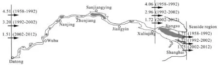
Fig.6 Sediment balance model in the Yangtze River Estuary (The data of 1958-1992 are from literatures[9], and those of 1992-2002 and 2002-2012 are obtained from the calculated results based on the terrain method according to the literatures[10])
2.2 Features of the sea entering sediments in the Yangtze River areas
Generally speaking, the concentrations of the sediments in a river change abruptly. In recent years(2003-2011), compared with the period of 1950-1968(Fig.5(a)), the sediments entering the sea are reduced to 3.46×10⁸t/y (by around 70.75%), and with a decreasing trend as well. Little change is seen from the 1950s to the early 1980s, while a clear decrease trend could be observed since the mid-1980s (Fig.5(b)). The sediment discharge reduction could be explained in several ways, such as the water storage and the sediment block of reservoirs in the basin, the relation adjustment of the lakes and the rivers in the middle and lower reaches, the water and soil conservation, the climate change, and so on. Recently, with the increasing frequency of human activity, the influences on the sea entering water flow rate, the sediment concentration and the allocation process were gradually being noticed[9,10]. Meanwhile, in the middle and lower reaches of the Yangtze River, the sediments of Dongting Lake and Poyang Lake flowing into the river also show a decreasing tendency. Also, the erosion extent is obviously reduced due to the water and soil conservation project in the upper reach, and the fact that the amount of sediments flowing into the Yangtze River mainstream is declined, which would influence the sediment content and the SSC entering the estuary. A comparison of the sediment concentration during 1950-1986 and during 1987-2002 shows that the average annual decrease is 30.0% during 2003-2011 as compared with a decrease of 67.5% in 1950-1986.
2.3 The input/output balance mode of the Yangtze River Estuary sediments
Based on the terrain method, the variations of the sediment output in different parts of the Yangtze River are statistically analyzed. The whole process is divided into three time periods, that is, 1958-1992,1992-2002 and 2002-2012, and these parts include the regions where the sediment flux enters the mouth of the Yangtze River through the Datong Hydrological Station, enters the estuary region from Xuliujing and enters the coastal region from the entrance. The reach from Datong to Xuliujing is silted up during the former two periods, while the siltation occurs in the reach from Xuliujing to the entrance during the whole process (Fig.6). The sediment flux entering the coastal areas outside the estuary sees a downward trend in the basin, and the variation of the SSC directly affects the ecological security elements like the chlorophyll, the transparency, and the fishing. The turbidity maximum zone in the coastal area outside the estuary is affected by the interaction between the runoffs and the tides,and also sees a re-suspension of sediments, which might adjust the SSC to a certain degree. In a word,the entered sediment content experiences a sharp decrease in this region, and it is closely related to the biological elements, the species, the delta riverbed evolution, and other factors whether the SSC could be maintained.
2.4 The trend of the SSC in the Yangtze River Estuary
The typical sections from the South and North Branches in the Yangtze River Estuary are chosen to compare the secular variation of the SSC. The Qinglonggang Section at the north branch, the Baimaosha Section at the South Branch, and the sections at the entrances of the South Channel, the North Channel and the South Passage are selected. The variations and the trends of the SSC are shown as follows:

Fig.7 The changes of the SSCs in the South Branch and North Branch
(1) As shown in Fig.7(a), the SSC at the Qinglonggang Section in the North Branch tends to decrease with the decrease of the flowing splitting ratio since 1958 and the reduction rate maintains at about 4% as long as after 2000. Therefore, the SSC in the north branch is not greatly affected by the watershed but is primarily affected by the tide power. For the SSC during the period of 1958-2007 at the Qinglonggang Section, the year 2002 is a cutoff point. With the same tidal range at Qinglonggang, the SSC decreases dramatically after 2002 when compared with that during the years prior to 2002. Fifteen to twenty percent of the sediment discharge from the Yangtze River is transported northwards. And the majority of that discharge goes upward along the North Branch and settles down there. The sediment diffused from the basin is the main source of the suspended sediment in the North Branch. A previous study[11]shows that except for a small amount from the upstream, the sediment in the North Branch comes mainly from the offshore sea area, whose sediment in turn mainly comes from the South Branch through diffusion and backward transport except for a very small amount from along the Northern Jiangsu section. This suggests that the sediment in the North Branch comes from the basin as well through diffusion and backward transport after being discharged to the offshore area. As the North Branch is not much affected by the runoff, its SSC tends to decrease under the same tidal range or tidal hydrodynamic force.
(2) Figure 7(b) shows that the SSC at the Baimaosha Section at the South Branch of the Yangtze River Estuary sees a decreasing trend. Although the divided flow ratio and the sediment splitting ratio in the north branch are decreased, while those in the South Branch are enhanced, the rapidly decreasing trend of the SSC affected by the Datong Station is observed. The channel training is carried out in the Baimaosha after 2004. With a sharp decrease of the incoming sediment from the basin, the riverbed tends to be eroded and the generated sediment compensates the suspended sediment to some degree. Consequently, the reduction of the SSC caused by the incoming sediment decrease is lowered. However, the SSC still shows an overall trend of decrease.
(3) Figure 7(c) shows the changes of the SSC in the South and North Channels. The SSC changes less during the period of 1958-1997 and tends to decrease during the period of 1997-2011. Although the decreases of the sediment discharge from the basin during the two periods are apparent and the decreases of the suspended sediment concentration in the South and North Channels are expected, the channel training is carried out in the region, which affects the local suspended sediment concentration. In addition, the suspended sediment and the riverbed sediment can be resuspended. As a result, the the decrease of the SSC is lowered.
(4) As shown in Fig.7(d), the SSC at the inlet of the South Passage does not show clear changes. In this time period, the diversion ratio of the runoff volume in the South Passage is increased while the sediment discharge from the basin is decreased sharply. As a result, the SSC in the surrounding environment is decreased, and the SSC at the inlet of the South Passagedoes not change much under the comprehensive impacts of various factors.

Fig.8 The changes of the SSC in the South Branch

Fig.9 SSC of South Branch against T/ R(Notes: in Fig.8 ○indicates a lack of tidal data)
The region from the Yangtze River Estuary to the lower seaside region includes the sections of the South Branch, the North Branch, and the South and North Channels. Using the image data from 15 Landsat's for the period of 1974-2009[6](Fig.8), it is shown that the SSC at the surface water of the South Branch at the estuary tends to decrease (Fig.7) when ignoring the effects of changes of the flow and the tide. In this study,to determine the influencing factors for the decrease of the SSC in the Yangtze River Estuary, the tide/runoff (T/ R)ratio[12]is introduced. It is defined as the ratio of the tidal range (HS)recorded at an observation station in the estuary over the flow discharge()Q from the watershed as given by the following equation

The remote-sensing data during the period of 1974-2009 for the Yangtze River Estuary are calibrated based on the T/ Rratio and the SSC at the South Branch is obtained (Fig.8). The data are divided into two sub-groups using the year 2003 as the dividing year. As shown in Fig.9, for the same tide/runoff combination, the SSC for the South Branch is lower during the period of 2003-2009 than that during the period of 1974-2002. In other words, for the same T/ R ratio, the SSC in the surface water sees a decreasing trend over the study period. As a whole, the suspended sediment concentration of the South Branch of the Yangtze River Estuary decreases with the decrease of the sediment into the sea basin.
In summary, influenced by the impoundment of the Three Gorges Reservoir, the annual distribution of the flow discharge from the Yangtze River sees a marked change, but the change in the long total volume does not show a clear trend. The sediment discharge shows a decreasing trend in the mid-1980s and influenced by the impoundment of the Three Gorges Reservoir, a rapidly decreasing trend is observed during the period of 2003-2011. Also influenced by the impoundment of the Three Gorges Reservoir, the overall SSC in the South Branch at the Yangtze River Estuary tends to decrease and the decreasing process is accompanied with that of the sediment discharge from the Datong Station. For a same runoff/tide combination,the SSC in the South Branch is decreased sharply,caused by the decrease of the sediment discharge after the impoundment of the Three Gorges Reservoir. Influenced by the channel training in Baimaosha, the decrease of the SSC in the inlet of the South Branch slows down. The decreases of the SSC at the inlet cross-sections of the South and North Channels slow down as compared with the decrease of the sediment in the Datong Station. The suspended sediment concentration of the North Branch is controlled by the sediment from the tides and the sediment of the North Branch comes from the sediment discharged from the South Branch, which is diffused into the North Branch with the flood current. In a same tidal range, the SSC in the North Branch tends to decrease. Overally, influenced by the impoundment of the Three Gorges Reservoir, the sediment discharge is decreased sharply,the SSC in the Yangtze River Estuary tends to decrease, and the decrease of the SSC in some regions slows down due to the channel training.
3. The influence of human activity on Ssc in the Yangtze Estuarine coastal region and North Channel
3.1 The change of SSC in the sea areas outside the Yangtze River Estuary
The SSC in the estuary area is mainly affected by the runoff volume, the sediment volume, the tide and the wave. The relations among the SSC in the Yangtze River Estuary and the above four factors are to be discussed in this section. The data from literature[13]are used, and the observation stations are at Xuliujing,Hengsha, Sheshan, Tanhu, Xiaoyangshan and Dajishan. The SSCs at Xuliujing, Hengsha, Sheshan, Dajishan, Xiaoyangshan, Luchao Port and Tanhu tend to decrease after 2003 as compared with those before2003, respectively. The SSC is decreased the greatest(by 56%) at Xuliujing, the least (by ca. 5%) at Sheshan, and by 20%-30% at the other stations (Table 1). And the correlation analyses show that the SSC decrease is significantly correlated with the water discharge and the sediment discharge but not so with the tidal range and the wave. This demonstrates that the SSC variation in the coastal area of the Yangtze River Estuary is mainly controlled by the water discharge and the sediment discharge from the basin (Table 1).

Table 1 Post-TGD changes of annually averaged SSC and influencing factors, and significance levels of the changes based on the rank-sum test[13]
The relations among the estuarine SSC and the water discharge, the sediment discharge, the tidal range and the wave are further studied using the 1998-2009 SSC data from the Xiaoyangshan Station. As can be seen from Fig.10, good relationships are observed and synchronous changes occur between the water/sediment discharge and the SSC at the Yangshan Port,while the relationships between the tidal range/wave and the SSC are poor. Therefore, the SSC variation in the estuary area of the Yangtze River is to be discussed based on the water discharge and the sediment discharge.
In view of the fact that the above spots cannot cover the entire coastal area, the SSC data measured in the sea areas outside the estuary from 1959 to 2010 are further analyzed. The cross sections of 122o30′and 123o00′ are used for the characterization of the sediment elements in the sea areas outside the estuary,and the cross sections of Subei and Hangzhou Bay are 32oand 30o, respectively (Fig.11). The result indicates that a slight decrease of SSC is observed in 122o30′ and 123o00′ cross sections since the 1950s. The SSC at the Subei cross-section tends to decrease but as its value is one order of magnitude lower than that of the SSC at the coastal area of the Yangtze River Estuary, its variation has a very slight effect on the SSC in the estuary.
In summary, the SSC in the sea area of the Yangtze River Estuary shows a trend of slight decrease. Compared with the percentage decrease of the sediment discharge from the basin, the SSC in the sea area of the estuary can be considered small. On a large time scale, the sea level change will cause a change of the hydrodynamic force pattern in the estuary, which in turn would influence the distribution of the SSC. However, on a relatively small time scale, the sea level change has a very slight influence on the estuary[14].
3.2 Variation tendency of the SSC in coastal area of the Yangtze River Estuary

Fig.10 The relations among the SSC at Xiaoyangshan Port and sediment and hydrodynamic power
After summarizing the SSC data for nearly 60 years in coastal areas outside the Yangtze River Estuary (121oE30′-123oE00′, 30oN45′-31oN45′), the whole process can be divided into three time periods of 1958-1984, 1985-2002 and 2003-2011 according to the chronological order. The average value of the SSC during the period of 1985-2002 is 0.42 kg/m3, and then it is reduced to 0.33 kg/m3after 2003, which means a reduction percentage of approximately 21.42% (Fig.12). The average concentration of the annual sediments flowing into the sea is 0.38 kg/m3during the period of 1985-2002, while the value is 0.17 kg/m3during the period of 2003-2011, the reduction percentage is 55.03%. The extent of the SSC reduction in the estuary coastal areas is lower than that of the sea entering sediment concentration because with the re-suspension of the sediments in the estuary areas the SSC is supplemented and adjusted to a certain degree. With the increase of the longitude, the SSC shows a transport pattern of low-high-low, and the high concentration core region is in the range of 122o00′-122o30′. During the period of 2003-2011, the core region shifts inward the estuary by about one sixth degree of longitude. It is a dry season during the period of 2003-2011 for the Yangtze River watershed and the runoff to the lower reach is small (Fig.12),which leads to a slightly enhanced tidal power during its confrontation with the runoff in the coast area. Consequently, the peak value of the SSC sees an inward shift to some extent. At the same time, with the re-suspension at the estuary area, a relatively high SSC might be maintained at the maximum turbidity zone for a short time. Although the re-suspension does not play a decisive role in the decreasing trends of the SSC in the coast area, primarily caused by the dramatic decrease of the incoming sediment from the upper reach, it does play a feeding and regulating role to some degree. The upstream movement of the peak SSC value zone is mainly related to the change of the water discharge from the river. The annual average water discharge is 9 160 m3/y in 1985-2002 and 8351 m3/y in 2003-2011, a decrease of about 8.83%. Hydrodynamically, the runoff and the tidal current are in equilibrium. The decrease of the runoff weakens the hydrodynamic force of the runoff. Consequently, the equilibrium point between the runoff and the tidal current interaction shifts upstream, causing a corresponding upstream movement of the peak SSC value zone.
3.3 The influence of estuarine deep-water channel improving project on the distribution of local SSC
The human activities include not only those activities in the watershed but also the channel training in the estuary area. The channel training of the local hydrodynamic force and the sediment can affect the SSC at the estuary. Since 1998, the Yangtze River Estuary North Deep-water Channel Improvement Project was constructed, which changes the local hydrodynamics,thereby causes a SSC change. In the study of human activities on the impact of the SSC, this paper focuses on the analysis of their individual cases, a clear mechanism of human activities and the natural SSC.
In the vertical direction of the North Passage, the distribution follows a pattern that the SSC is higher in the middle and lower in the upper and bottom parts,no matter whether there are floods or ebbs, and the peak value moves upward or downward in different years (Fig.13). The variation tendency of the North Passage SSC in different time periods is shown in Fig.14. When comparing the information during the period of 2008-2011 with that during the period of 2000-2007, a decreasing trend of the SSC can be observed in the upper and lower parts of the channel during both floods and ebbs, while an increase occurs in the middle part. During the whole flood period, the average concentration in the upper and lower parts is reduced by 9.36%-17.50%, and the mean value is around 14.25 %, the decreasing magnitude is larger than that of the SSC in the whole coast area.

Fig.11 Variations of SSC in the coastal areas outside the Yangtze River Estuary

Fig.12 Variations of SSC in the coastal area

Fig.13 Variations of SSC in the North Passage

Fig.14 Variations of SSC in the North Passage
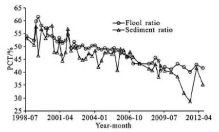
Fig.15 Variations of WSSR in the North Passage (P)
Both the divided flow ratio and the sediment splitting ratio at the sections at the entrance and the exit of the North Passage during the period of 1998-2009(Fig.15) show decreasing trends, which leads to a decrease of the sediment amount transported to the North Passage. While the SSC in the surrounding environment of the North Channel is decreased, the decreasing magnitude of the SSC in the North Passage is larger than that in the coast area. From the hydrological point of view, the middle section of the North Passage is the overlapping area of the activity areas of the maximum turbidity zone, the flow stagnation point and the sediment stagnation point. A mechanism breaking-down analysis shows an obvious sediment accumulation mechanism in that area. The apparent sediment resuspension effect in the estuary area is a result of the hydrodynamic force. To what extent the sediment exchange can play important roles depends on the hydrodynamic force, the sediment composition,and other factors. The diversion ratio for the North Passage tends to decrease recently. Although the flow stagnation point shifts slightly towards upstream[15],the relative changes of the runoff/tidal hydrodynamic forces are small[16]. During the 1st phase of the deepwater channel construction project in the North Passage, the sediment at the bed surface shows a trend of turning coarser[17]. Such a coarsening trend is observed in the Augusts of 2002, 2005, 2007, 2008 and 2011 (Fig.16). According to the data reported in previous studies, the bed surface sediment has an median diameter of 0.0233 mm (54 measuring sites) in April 2012[18], demonstrating that the bed surface sediment in the North Passage displays a trend of becoming coarser. Meanwhile, the median diameter of the suspended sediment in the North Passage shows a trend of becoming finer[19]. Consequently, impacted by the hydrodynamic force, the resuspended effect is weakened,which inevitably causes a decrease of the suspended sediment concentration in the middle section of the North Passage. Additionally, the suspended sediment concentrations in the surrounding areas also tend to decrease. Thereby, the increase in the middle section of the North Passage is not consistent with the above conditions. Recently, a series of hydrological observations show that marked amounts of sediment go across the dikes into the North Passage, mainly in the middle section of the North Passage during flood periods[20]. The data of August/September, 2011 and September,2012 show that the sediment from across the south diversion dike is the major sediment source of the North Passage. And the water and sediment transport in the North Passage displays a feature that large amounts are observed during spring tides while small amounts during neap tides[20]. Specifically, the amount of sediment entering the North Passage from across the south diversion dike during the spring tides of August/ September, 2011 is 2.36 times of that during ebb tides at the upper mouth and 1.84 times of that during flood tides at the lower mouth. The net transported amount of sediment is 8.31 times of that at the upper mouth. The amount of sediment entering the North Passage from across the south diversion dike during the spring tides of September, 2012 is 5.46 times of that during ebb tides at the upper mouth and 1.93 times of that during flood tides at the lower mouth. The net transported amount of sediment is 14.5 times of that at the upper mouth[20]. That is to say, the majority of the sediment in the North Passage comes from across the diversion dike. It is clear from the above analyses that it is the sediment across the diversion dike into the North Passage that maintains the suspended sediment concentration there and is the major source of sediment for the North Passage. However, more observations on the North Passage are required to further determine its sediment source, sediment deposition and sediment exchanging processes as it is a part of the estuary system.

Fig.16 Median particle size change in North Passage Surface Bed
To sum up, the correlation analyses between the SSC in the major controlling stations at the YangtzeRiver Estuary and the runoff volume, the tidal range,the wave, the sediment discharge and so on demonstrate that the changes of the SSC are mainly controlled by the flow volume and the sediment volume of the runoff and that the changes of the water and sediment discharges from the basin are the major factors influencing the changes of the SSC in the coast area. The SSC at the Yangtze River offshore area is decreased as the sediment discharge is decreased. Influenced by the recent low runoff volume, the peak value zone of the SSC shifts upstream for approximately 1/6oof longitude. Comprehensively influenced by the decreased sediment discharge, the coarser bed sediment and the channel training, the SSC in the upper and lower sections of the North Passage tends to crease and influenced by the sediment that goes over the diversion dike, the SSC in the middle section tends to increase.
4. Conclusions
(1) In both the flood season and the dry season,as well as for the whole year, the sediment discharge rate and the SSC in the estuary area of the Yangtze River show decreasing trends. In the estuary area, the amount of sediment transported into the South and North Branches and the offshore area also tends to decrease over the years.
(2) The SSCs at the sections at the entrances of the South Branch, the South Port, the North Channel and the South Passage in the Yangtze River Estuary show decreasing trends during the period of 1959-2011. Remote-sensing data reveal that for the same runoff/tide combination, the SSC in the surface water is decreased, caused by the dramatic decrease of the sediment discharge and the sediment content from the watershed.
(3) Although the SSC in the offshore area does not exhibit an apparent decreasing trend, the SSC in the nearshore area is dropped by 21.42% during the period of 2003-2011 when compared with that during the period of 1985-2002 before the impounding of the Three Gorges Reservoir. The sediment re-suspension in the estuary slows down the reduction of the SSC. The period of 2003-2011 is the dry season for the Yangtze River, when the flow is relatively low. The peak value of the SSC in the coast area shifts inwards for about 1/6oof longitude.
(4) Due to the deepwater channel improvement project in the North Passage at the Yangtze River Estuary since 1998, the SSC in the waterway area is decreased. With the decrease of the divided flow ratio and the sediment splitting ratio in the entrance and exit of the North Passage, the SSC in the upper and lower reaches of the North Passage during the period of 2008-2011 is decreased by about 14.25% compared with that during the period of 2000-2007. Primarily due to the jetty at the south side, the SSC in the middle reach displays an increasing trend.
[1] FU K. D., HE D. M. and LU X. X. Sedimentation in the Manwan reservoir in the Upper Mekong and its downstream impacts[J]. Quaternary International, 2008,186(1): 91-99.
[2] KUMMU M., VARIS O. Sediment-related impacts due to upstream reservoir trapping, the lower Mekong River[J]. Geomorphology, 2007, 85(3): 275-293.
[3] MORAIS P., CHICHARO A. and CHICHARO L. Changes in a temperate estuary during the filing of the biggest European dam[J]. Science of the Total Environment, 2009, 407(7): 2245-2259.
[4] YANG Yun-ping, LI Yi-tian and SUN Zhao-hua et al. Suspended sediment load in the turbidity maximum zone at the Yangtze River Estuary: The trends and causes[J]. Journal of Geographical Sciences, 2014, 24(1):129-142.
[5] HE Chao. Comparison study of suspended sediment distribution in the Yangtze Estuary's adjacent sea area in recent 20 Years[D]. Master Thesis, Shanghai, China:East China Normal University, 2007(in Chinese).
[6] CHEN Yong, HAN Zhen and YANG Li-jun et al. The spatial and temporal distribution of suspended sediment concentration and its response to environmental change in the Changjiang Estuary[J]. Acta Oceanologica Sinica, 2012, 34(1): 145-152(in Chinese).
[7] JIN Miu, YU Zhi-ying and HE Qing. On the relationship between maintenance conditions of Yangtze Estuary deep-water channel and water and sediment transport from the valley[J]. Port and Waterway Engineering,2006, (3): 46-51(in Chinese)
[8] ZHAI Xiao-ming. Elementary discussion of hydrodynamic and suspended sediment distribution characteristic in the Yangtze Estuary[D]. Master Thesis,Shanghai, China: East China Normal University,2006(in Chinese).
[9] WU Hua-lin, SHEN Huan-ting and YAN Yi-xin et al. Preliminary study on sediment flux into the sea from Changjiang Estuary[J]. Journal of Sediment Research,2006, (6): 75-81(in Chinese).
[10] WANG Jun, TIAN Chun and ZHANG Zhi-lin. Fluvial processes and governance in Yangtze Estuary[M]. Beijing, China: China Water Power Press, 2014(in Chinese).
[11] YANG Ou, LIU Cang-zi. Analysis on sediment transport patterns and sediment sources of north branch of Changjiang Estuary[J]. Journal of Hydraulic Engineering, 2002, (2): 79-84(in Chinese).
[12] YANG Yun-ping, LI Yi-tian and HAN Jian-qiao et al. Variation of tide limit and tidal current limit in Yangtze Estuary and its impact on projects[J]. Journal of Sediment Research, 2012, (5): 46-51(in Chinese).
[13] LI P., YANG S. L. and MILLIMAN J. D. et al. Spatial,temporal, and human-induced variations in SSC in the surface waters of the Yangtze Estuary and adjacent coastal areas[J]. Estuaries and Coasts, 2012, 35(5): 1316-1327.
[14] ZHOU X., ZHENG J. and DOONG D. J. et al. Sea level rise along the East Asia and Chinese coasts and its role on the morphodynamic response of the Yangtze RiverEstuary[J]. Ocean Engineering, 2013, 71: 40-50.
[15] YANG Yun-ping, LI Yi-tian and WANG Dong et al. Progress of study of stagnation point in Yangtze River Estuary[J]. Journal of Sediment Research, 2011, (6):1-6(in Chinese).
[16] WAN Y., GU F. and WU H. et al. Hydrodynamic evolutions at the Yangtze Estuary from 1998 to 2009[J]. Applied Ocean Research, 2014, 47(9): 291-302.
[17] LOU Fei, YU Zhi-ying and HE Qing. Distribution characteristics of channel and shoal sediment and its affecting factors after the first phase of the Changjiang River Estuary North Channel Project[J]. Advices in Marine Science, 2005, 23(2): 183-189(in Chinese).
[18] ZHAO Fang-fang. Temporal and spatial variations and transport mechanisms of suspended sediment in the middle reach of North Passage in the Yangtze Estuary[D]. Master Thesis, Shanghai, China: East China Normal University, 2014.(in Chinese).
[19] LIU Hong, HE Qing and WANG Ya et al. Processes of suspended sediment mixture in the Yangtze River Estuary[J]. Acta Geographica Sinica, 2012, 67(9): 1269-1281(in Chinese).
[20] LIU Jie. Yangtze Estuary Deepwater Channel erosion and siltation study evolution[M]. Beijing, China:China Ocean Press, 2014, 72-73(in Chinese).
* Project supported by the International Scientific and Technical Cooperation Program of China (ISTCP) (Grant No. 2013DFA81540), the National Natural Science Foundation of China (Grant Nos. 51579123, 51209112).
Biography: YANG Yun-ping (1985-), Male, Ph. D.,
Senior Engineer
猜你喜欢
杂志排行

水动力学研究与进展 B辑的其它文章
- An effective method to predict oil recovery in high water cut stage*
- Experimental study of breach process of landslide dams by overtopping and its initiation mechanisms*
- Implicit large eddy simulation of unsteady cloud cavitation around a planeconvex hydrofoil*
- Prediction of ship-ship interactions in ports by a non-hydrostatic model*
- Flow hydrodynamics in embankment breach*
- Experimental investigation of motion responses of tunnel element immerging by moored barge*