2022年西北太平洋和南海台风活动概述
2023-12-21聂高臻,钱奇峰
聂高臻,钱奇峰
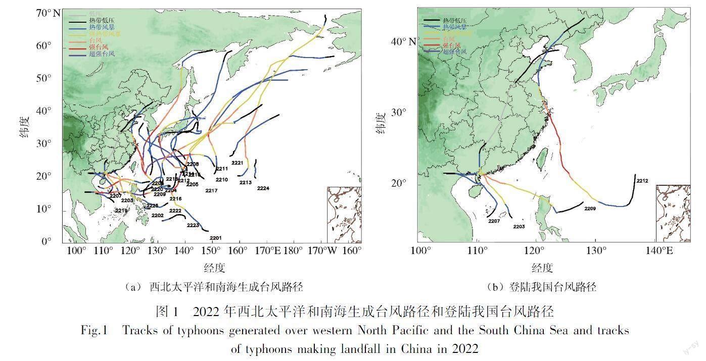
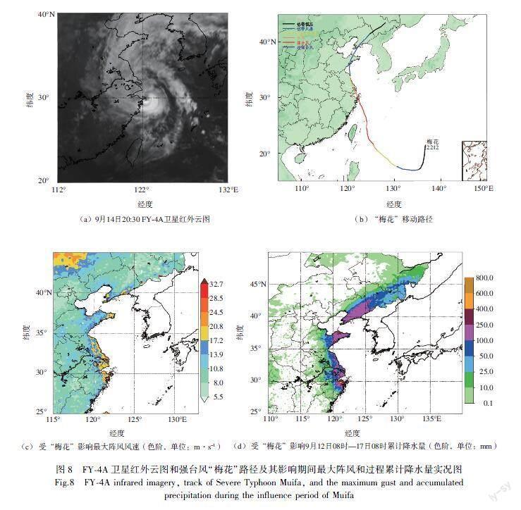
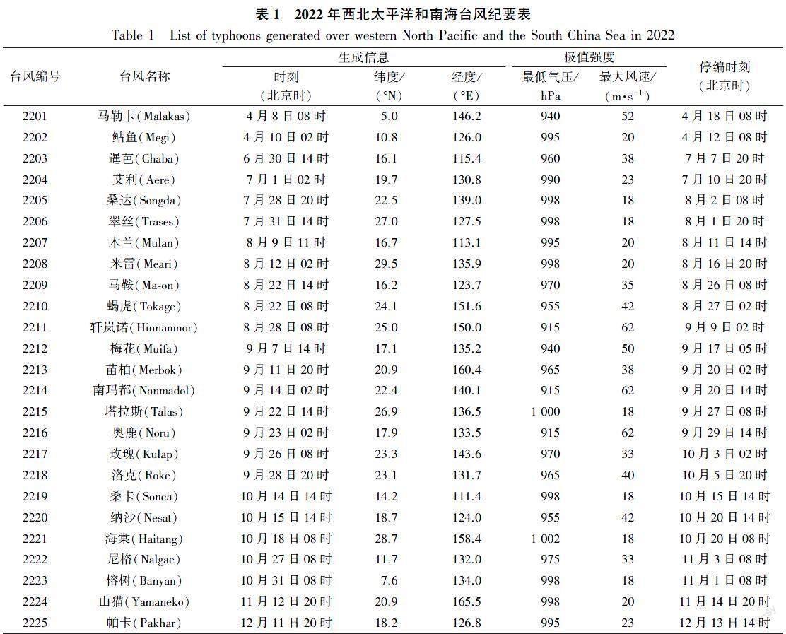
摘要:利用中国气象局热带气旋最佳路径等资料,对2022年西北太平洋及南海台风活动的主要特征和影响我国台风的路径、强度及风雨影响进行分析和回顾。结果表明:2022年西北太平洋及南海台风生成个数与常年持平,台风总体强度偏弱,生成源地显著偏北;登陆台风个数偏少,登陆强度偏弱;有3个台风集中在广东西部登陆,另外强台风“梅花”是1949年以来首个4次登陆不同省份的台风。全年多台风事件频发,共存的台风共计有11组,历史罕见。2022年台风灾害影响较轻,夏台风偏少,秋台风活跃。
关键词:台风;登陆台风;活动特征;多台风事件;台风源地
Overview of typhoon activities over western North Pacific and the South China Sea in 2022
NIE Gaozhen, QIAN Qifeng
(National Meteorological Center, Beiing 100081, China)
Abstract: Using the data such as the CMA (China Meteorological Administration) Tropical Cyclone Best Track Dataset, an analysis and review are conducted on the main characteristics of the 2022 typhoon activities in western North Pacific and the South China Sea, focusing on the tracks, intensities, and wind and rainfall impacts of the typhoons affecting China. The results are as follows. In 2022, the number of typhoons generated in western North Pacific and the South China Sea is consistent with the annual average, and the overall intensity of typhoons is relatively weak with significant northward shifts in their genesis regions. The number of landfalling typhoons is less, and their intensities upon landfall are comparatively weak. Three typhoons make landfall concentratedly in the western part of Guangdong, while the severe typhoon Muifa has become the first to make landfall in 4 different provinces since 1949. The multiple typhoon coexisting scenarios occur throughout the year with a total of 11 typhoon groups, which is a rare phenomenon. The typhoon-related disasters in 2022 exert relatively mild impacts, the summer of 2022 experiences less typhoons, while the autumn is characterized by intense typhoon activities.
Keywords: typhoon; landfalling typhoon; characteristics of activity; multiple typhoon coexisting scenario; typhoon genesis region
引言
我國拥有漫长的海岸线,毗邻全球热带气旋最活跃的西北太平洋,是世界上受台风影响最频繁、最严重的国家之一[1]。台风可以带来强风、暴雨、风暴潮以及渍涝山体滑坡、泥石流等一系列直接和次生灾害[2-3],威胁人民生命安全,并造成数额巨大的经济损失。中央气象台每年对过去一年台风活动特点进行概括总结[4-6],其中对台风的生成、登陆、活动特征的统计以及对风雨影响的回顾总结有助于更好地理解台风活动规律、发现科学问题,推动台风机理和相关预报预测技术发展,提高台风预报预测准确率,最终服务于防灾减灾。
2021年9月—2023年1月出现了一次超长时间维持的弱拉尼娜事件[7-8],这是自2020年8月以来,罕见地连续3个冬季经历拉尼娜事件,因此也被称作三峰(triple-dip)拉尼娜事件[9-10]。研究表明,厄尔尼诺-南方涛动(El Ni?o-Southern Oscillation,ENSO)与台风活动的频数、空间分布有关[11-13],拉尼娜事件期间台风生成位置会更加偏北、偏西[14]。……