生态视角下凤凰县建设用地适宜性评价
2021-10-22吴方兴,毛慧娟,陈诚,彭小林
吴方兴,毛慧娟,陈诚,彭小林
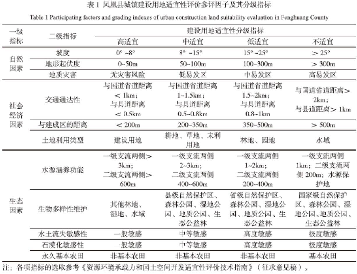
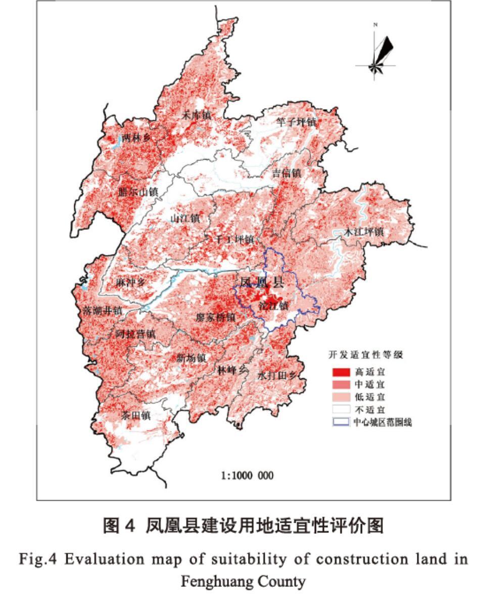
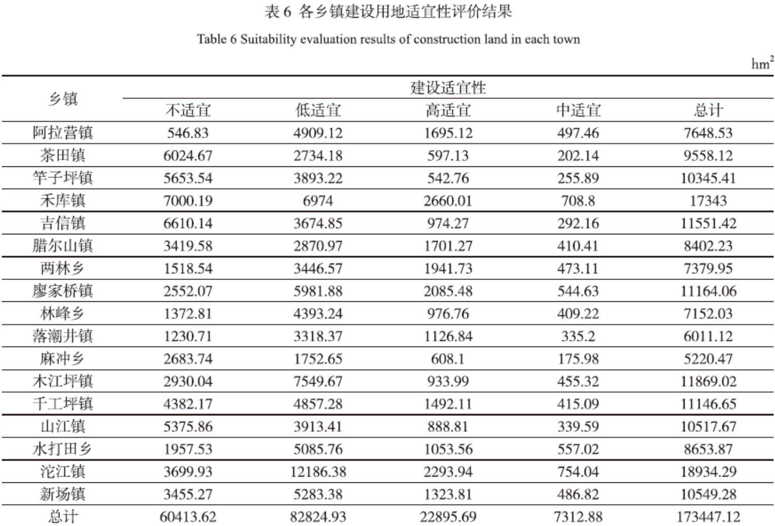
摘 要 山地地区地形地貌更加敏感和脆弱,本文在构建建设用地适宜性评价指标时引入水土流失和石漠化等生态敏感性因子和脆弱性因子,采用层次分析法确定评价因子权重,依托ArcGIS10.3空间分析,提高评价的效果和精度。以凤凰县为例,识别生态重要性区域和建设开发适宜性区域,为国土空间规划生产、生活、生态的三生空间划定提供参考依据。
关键词 生态视角;建设用地适宜性;层次分析法;凤凰县
中图分类号:F301 文献标志码:A
Evaluation of Suitability of Construction Land in Fenghuang County from an Ecological Perspective
Wu Fangxing1, Mao Huijuan1, Chen Cheng1 , Peng Xiaolin2
(1. The Second Surveying and Mapping Institute of Huanan Province, Changsha Hunan 410015;
2. Fenghuang County Natural Resources Bureau, Hunan Fenghuang 416200)
Abstract: The topography and geomorphology of mountainous areas were more sensitive and fragile. Ecological sensitivity and fragility factors such as soil erosion and rocky desertification were introduced in this paper when constructing construction land suitability evaluation indicators. Analytic hierarchy process was used to determine the evaluation factor weights. ArcGIS 10.3 spatial analysis improves the effect and accuracy of evaluation. Taking Fenghuang County as an example, the identification of ecologically important areas and suitable areas for construction and development provide a reference basis for territorial and spatial planning of production, life, and ecology.
Keywords: ecological perspective; suitability of construction land; analytic hierarchy process; Fenghuang County
根據《中共中央 国务院关于建立国土空间规划体系并监督实施的若干意见》(中发
〔2019〕18号)[1],资源环境承载力和国土空间开发适宜性评价(以下简称双评价)[2]是优化国土空间开发保护格局、划定生态保护红线、永久基本农田、城镇开发边界,确定用地指标的参考依据。资源环境承载力评价强调的是底线思维,关注的是资源环境承载的下限对人类活动的约束;而国土开发适宜性强调的是天花板思维,关注的是空间开发的上限。
城镇建设用地适宜性评价是城市规划的基础,影响城市各功能布局与经济社会发展。国内建设用地适宜性评价从20世纪90年代开始,到现在已形成比较成熟的研究体系,主要特点为:(1)评价单元以县域为主;(2)评价方法有模糊评价法、神经网络模型、情景分析法、多因子叠加分析法等;(3)评价类型以平原和丘陵地区为主。在生态视角下评价山地城市建设用地适宜性,孙凌蔚、李月臣等人虽考虑了生态敏感性、生物多样性维护、重要生态区等重要因子,但代表性不强。……