土地调查数据库在国土资源管理中的应用分析
2021-04-13李美玉
李美玉
摘要:第三次全国国土调查是土地调查向自然资源调查的过渡,是我国首次对山、水、林、田、湖、草、海等自然资源全要素统一进行的一次系统性调查,是一次很重要的国情国力调查。其调查成果作为一系列国家政策规划实施的核心基础数据,土地调查数据库体现了各行业用地的权属、结构、数量和分布,是政府部门科学制定土地政策、合理确定土地供应总量、落实土地调控目标的重要依据,为国土资源管理规划提供重要依据和参考。
关键词:土地调查 数据库 国土资源管理 基础数据
Application Analysis of Land Survey Database in Land and Resources Management
LI Meiyu
(Yuanjiang Natural Resources Bureau, Yiyang, Hunan Province, 413199 China)
Abstract:The third national land survey is the transition from land survey to natural resources survey. It is the first systematic survey of all elements of natural resources such as mountain, water, forest, field, lake, grass and sea in China. It is a very important survey of national conditions and national strength. As the core basic data for the implementation of a series of national policies and plans, the land survey database reflects the ownership, structure, quantity and distribution of land in various industries. It is an important basis for government departments to scientifically formulate land policies, reasonably determine the total amount of land supply and implement land regulation objectives, and provides an important basis and reference for land and resources management planning.
Key Words: Land survey; Database; Basic data; Land resources management
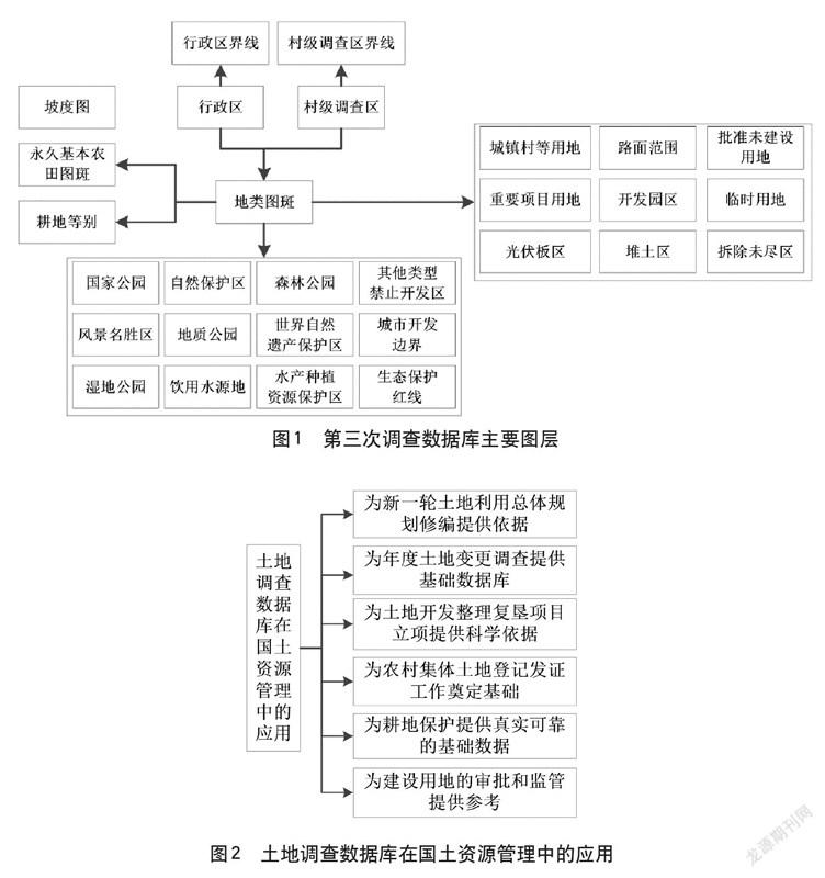
第三次國土调查(以下简称“三调”)是在第二次土地调查的基础上进行的详查,综合确定全国土地利用现状,为构建各级土地调查数据库奠定基础[1]。丰富国土资源大数据成果、健全监测统计体系,从而为经济发展和国土资源管理提供详实的数据资源。三调数据库是三调结果的主要载体,是总结和应用三调的数据来源,是衔接自然资源管理的核心,数据库的好坏关系到测绘工作的成败。同时,一个高质量的数据库结果是深化数据在国土资源管理中应用的前提,也是国土空间利用管控和生态保护修复的责任,解决多图重复,保障山水林田湖草实现自然恢复和综合管理等。
与第二次土地调查相比,第三次调查要求更高的精度、更完整的调查内容和更高的质量要求。为规范数据库建设,保证数据库结果质量,国家组织编制全国统一的数据库标准和数据库建设技术规范。……
