基于GIS与全排列多边形的长沙市土地节约集约利用评价
2016-10-19张禾裕张建勇陈亚凯王涛
张禾裕 张建勇 陈亚凯 王涛
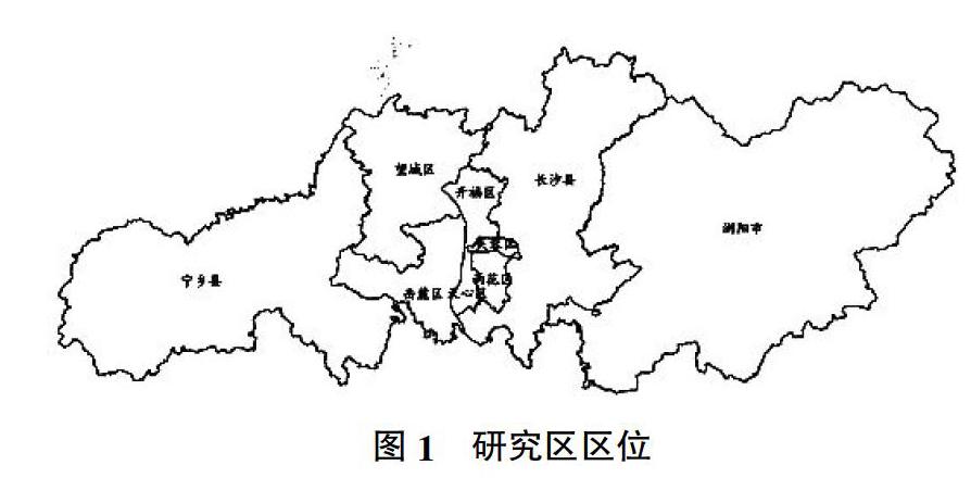

摘要:借助全排列多边形图示指标法的思想方法,选取长沙市作为研究对象,构建了区域土地节约集约利用评价的指标体系,进行了包含9项指标的定量化评价。结果表明,长沙市总体的土地节约集约利用综合程度整体保持增大趋势,且增速越来越快,各县(区、市)的土地节约集约利用水平在2010年之后表现为芙蓉区>天心区>雨花区>开福区>岳麓区>长沙县>望城区>浏阳市>宁乡县,5个市辖区的节约集约利用水平高于长沙市总体水平,而其余的4个县(区、市)的节约集约利用水平低于长沙市总体水平,长沙市各区县的土地节约集约利用程度及增幅与距芙蓉区的距离反相关。
关键词:节约集约利用;长沙;全排列多边形图示;指标法
中图分类号:S159 文献标识码:A 文章编号:0439-8114(2016)08-1943-06
DOI:10.14088/j.cnki.issn0439-8114.2016.08.011
Abstract: Entire-array-polygon graphical representation and indictor method, a new method used in eco-city evaluation, was used to evaluate the degree of economical intensive land use(EILU). Changsha in Hunan Province was taken as a case study area, an evaluation system including 9 indices was built to quantitatively assess the degree of EILU. The results showed that the overall EILU in Changsha extent kept increasing trend, and with a rapid increase. In 2010, the EILU degree from high to low for counties and districts in Changsha was Furong, Tianxin, Yuhua, Kaifu, Yuelu, Changsha county, Wangcheng, Liuyang and Ningxiang. The five municipal districts were higher than the overall level of Changsha city, while the four counties (districts and municipalities) were lower, and the extent and growth of EILU for all were inversely related with the distance from the Furong District.
Key words: economical intensive land use; Changsha; entire-array-polygon graphical representation; indicator method
土地節约集约利用是以合理布局、优化用地结构和可持续发展的思想为指导,通过增加存量土地投入、改善经营管理等途径,不断提高土地的使用效率和经济效益,实现更高的经济、社会和生态效益[1]。随着中国经济社会的快速发展,城市化水平日益提高,建设用地盲目扩张,耕地资源锐减,中国正面临着用地日益紧缺、生态环境问题凸出的难题,节约集约利用土地是解决这一难题的重要举措[2]。开展土地节约集约利用评价,有助于认识区域土地利用状况,更好地指导土地节约集约利用。
研究者针对区域土地利用状况、不同土地利用方式开展了大量的研究与实践工作[3],主要集中于土地可持续利用[4]、土地用途管制[5]、优化城市用地与规划[6]和耕地保护[7]等方面。中国该方面的工作……