基于无人机点云数据的河流DEM创建研究
2023-08-01刘欣
刘欣

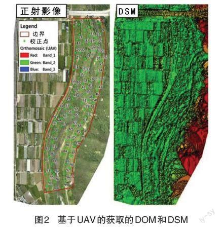
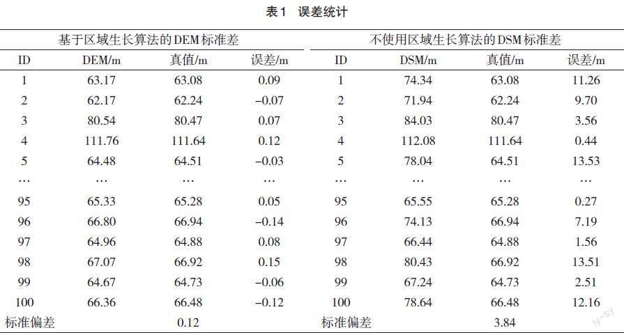
摘要:河流地區的地理空间信息对于河流管理(如河流规划,洪水分析和泥沙负荷分析)至关重要。无人机(Unmanned Aerial Vehicle,UAV)技术已广泛应用于获取三维地形,其直接获取的是数字表面模型(Digital Surface Model,DSM),包括地表植被、建(构)筑物等地物的高程信息。该文以北京市内某河流为工程背景,使用区域增长算法,基于无人机获取的点云数据提取地面点,创建区域数字高程模型(Digital Elevation Model,DEM),并使用虚拟参考站(Virtual Reference Station,VRS)和全站仪量测检测点坐标,检验所获取DEM的精度,验证基于无人机点云数据创建DEM的有效性。因此,可以通过应用基于区域增长算法的无人机点云来生成DEM,并将其有效地用于河流管理中。
关键词:无人机 点云 区域增长法 河流地形数据
中图分类号:P332;P23 文献标识码:A
Research on the Creation of the River DEM Based on UAV Point Cloud Data
LIU Xin
(AVIC Institute of Geotechical Engineering Co., Ltd., Beijing, 440001 China)
Abstract: The geospatial information of river areas is critical for river management (such as river planning, flood analysis and sediment load analysis). Unmanned aerial vehicle (UAV) technology has been widely used to obtain 3D terrain, and it directs acquires the digital surface model (DSM), including the elevation information of ground objects, such as surface vegetation, buildings (structures), etc. This paper takes a river in Beijing as the engineering background, uses the regional growth algorithm to extract ground points from the point cloud data obtained by UAV and create the digital elevation model (DEM), and uses the virtual reference station (VRS) and total station to measure the coordinates of detection points, test the accuracy of the obtained DEM, and verify the effectiveness of creating the DEM based on UAV point cloud data. Therefore, the DEM can be generated by applying UAV point clouds based on the regional growth algorithm, and it will be effectively used in river management.
Key Words: UAV; Point cloud; Region growing method; River terrain data
河流周围地区的4D产品对于河流的综合管理至关重要,可以用于限制河流环境内的过度开发和执行灾害管理任务[1]。很多研究一直在利用地形数据进行河流管理任务,如用于制订基本的河流维护计划、水利设施安装、洪水分析和泥沙排放分析等[2]。
与传统测图方法相比,无人机摄影测量可获取地表地物4D产品,获取的信息更全面。近年来,基于无人机(Unmanned Aerial Vehicle,UAV)创建三维地形数据得到了广泛应用。无人机配备有全球卫星导航系统(Global Navigation Satellite System,GNSS)和惯性导航系统(Inertial Navigation System,INS),用于获取位置信息的传感器以及用于捕获影像的摄像头。此外,一些项目中已经使用了能够进行虚拟参考站(Virtual Reference Station,VRS)调查的无人机设备,从而可以更快地进行地形建模[3]。
基于无人机获取三维地形的研究大多都集中在应急防灾、城市规划、林业和农业上,这些应用中获取的地形数据为包括所有地形特征的数字表面模型(DigitalSurface Model,DSM)影像。……
