基于Sentinel-1A影像的原阳县玉米和水稻分类时间窗选择
2023-06-08李长春翟伟广王春阳陈伟男吴喜芳顾明明
李长春 翟伟广 王春阳 陈伟男 吴喜芳 顾明明
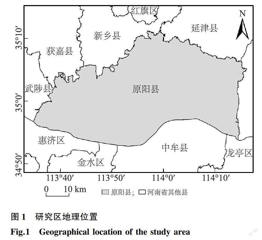
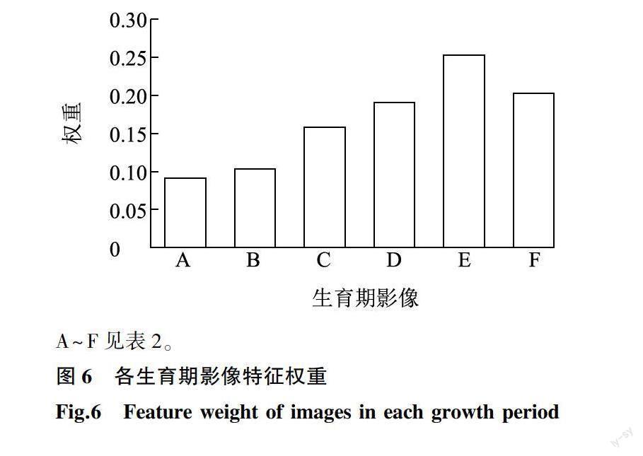
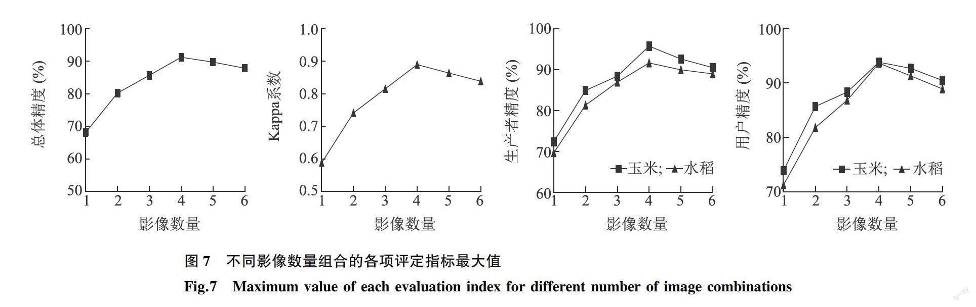
摘要: 使用遙感技术可以快速、准确地识别作物类型。本研究以河南省原阳县为试验区,基于Google Earth Engine(GEE)云平台,以玉米、水稻关键生育期的Sentinel-1A影像为数据源,分析各类地物的极化特征时序曲线。对6期Sentinel-1A影像进行穷举组合,使用随机森林算法对所有影像组合分类,分析各生育期影像对作物分类的重要性,选出玉米、水稻分类最佳时间窗。结果表明,作物生长中后期影像对作物分类更重要,其中玉米的乳熟期最重要,水稻的灌浆期最重要。全生育期影像组合中玉米的用户精度和生产者精度分别为90.43%和90.53%,水稻的用户精度和生产者精度分别为88.89%和89.01%。经过优选,大喇叭口期至成熟期为玉米分类最佳时间窗,相较于全生育期影像组合,此生育期影像组合的玉米用户精度和生产者精度分别提高了3.38个百分点和5.26个百分点;拔节期至成熟期为水稻分类最佳时间窗,相较于全生育期影像组合,此生育期影像组合的水稻用户精度和生产者精度分别提高了4.73个百分点和2.66个百分点。本研究结果可以为Sentinel-1A影像在原阳县及其附近区域的玉米、水稻种植结构监测研究提供理论依据。
关键词: Sentinel-1A影像;玉米;水稻;生育期;随机森林;时间窗
中图分类号: S127 文献标识码: A 文章编号: 1000-4440(2023)02-0413-10
Time window selection of corn and rice classification in Yuanyang County based on Sentinel-1A image
LI Chang-chun1, ZHAI Wei-guang1, WANG Chun-yang1, CHEN Wei-nan1, WU Xi-fang1, GU Ming-ming2
(1.School of Surveying and Land Information Engineering, Henan Polytechnic University, Jiaozuo 454000, China;2.The First Geological Brigade of Henan Province Nonferrous Metals Geology and Mineral Bureau, Zhengzhou 450000, China)
Abstract: The use of remote sensing technology can quickly and accurately identify crop types. Taking Yuanyang County of Henan province as the research area, based on Google Earth Engine (GEE) cloud platform and Sentinel-1A images of corn and rice at the key growth period, the polarization characteristic time series curves of various ground objects were analyzed. The six Sentinel-1A images were combined exhaustively, and the random forest algorithm was used to classify all image combinations, analyze the importance of images in each growth period to crop classification, and select the best time window for corn and rice classification. The results showed that the image of the middle and late growth stages of crop growth was more important for classification. The milk ripening stage of maize was the most important, and the filling stage of rice was the most important. In the whole growth period image combination, the user accuracy and producer accuracy of corn were 90.43% and 90.53% respectively, and the user accuracy and producer accuracy of rice were 88.89% and 89.01% respectively. After optimization, the best time window for maize classification was from big bell stage to mature stage. Compared with the image combination in the whole growth stage, the user accuracy and producer accuracy of maize improved by 3.38 percentage points and 5.26 percentage points, respectively. The best time window for rice classification was from jointing stage to maturity stage. Compared with the image combination in the whole growth stage, the user accuracy and producer accuracy of rice increased by 4.73 percentage points and 2.66 percentage points, respectively. The results of this study can provide a theoretical basis for the monitoring and research of corn and rice planting structure in Yuanyang County and its nearby areas with Sentinel-1A image.
Key words: Sentinel-1A image;corn;rice;growth period;random forest;time window
随着城市的快速发展以及人口的不断增加,粮食安全已逐渐成为人们共同关注的问题[1-3]。及时、准确获取作物种植类型和空间分布信息可以保障粮食安全,促进社会经济发展[4]。……