基于GEE和Landsat时间序列数据的海南岛土地利用分类研究
2021-12-23戴声佩易小平罗红霞李海亮李茂芬郑倩胡盈盈
戴声佩 易小平 罗红霞 李海亮 李茂芬 郑倩 胡盈盈
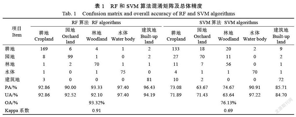
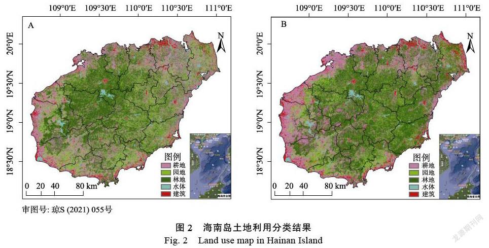
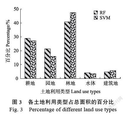
摘 要:土地利用/覆盖变化(land use/cover change,LUCC)是当前全球变化研究的核心内容之一。土地利用遥感监测是土地利用变化相关研究的重要技术手段,尤其是高分辨率遥感技术和谷歌地球引擎(Google Earth Engine,GEE)云计算平台的出现,为土地利用空间信息的获取提供了新的途径和方法。本研究基于GEE云平台提供的Landsat-8 OLI时间序列卫星影像数据,采用随机森林(random forest,RF)和支持向量机(support vector machines,SVM)分类算法,对海南岛土地利用类型进行了遥感分类研究。结果表明:RF与SVM算法对海南岛土地利用中水体和建筑用地的分类精度均较高,对耕地、园地和林地分类精度较低。与SVM方法相比,RF分类方法能够更准确识别各类地物信息,更适于海南岛土地利用分类的研究。海南岛林地(包括天然林、橡胶林等)所占比例最大,主要分布在海南岛中部;耕地和园地面积接近,相间分布于海南岛大部分区域;水体和建筑用地面积较小,在海南岛均呈零散的分布状态,以沿海地区为主。GEE平台对于开展大区域土地利用分类与遥感动态监测具有重要的意义。
关键词:GEE;Landsat;土地利用;海南岛
中图分类号:P237 文献标识码:A
Abstract: Land use/cover change (LUCC) is one of the core contents of global change research. Land use remote sens-ing monitoring is an important technical for land use change research, especially the emergence of high-resolution re-mote sensing technology and Google Earth Engine (GEE) cloud computing platform, which provides a new way and method for obtaining land use spatial information. Based on the Landsat-8 OLI time series data provided by GEE cloud platform, the random forest (RF) and support vector machines (SVM) classification algorithm was used to mapping land use in Hainan Island. The results show that both RF and SVM algorithms have higher classification accuracy for water and building land, and have lower accuracy for cultivated land, garden land and forest land. Compared with SVM method, RF classification method could identify all kinds of land features more accurately and is more suitable for the study of land use classification in Hainan Island. The largest proportion of forest land (including natural forest, rubber forest, etc.) in Hainan Island is mainly distributed in the central part of Hainan Island. The area of cultivated land and garden land are distributed alternately in most areas of Hainan Island. The area of water body and construction land is small, which are scattered in Hainan Island, mainly in coastal areas. GEE platform is an useful tool for land use classification and remote sensing dynamic monitoring in large areas.
Keywords: Google Earth Engine (GEE); Landsat; land use; Hainan Island
DOI: 10.3969/j.issn.1000-2561.2021.11.038
土地利用/覆盖变化(land use/cover change,LUCC)既是当前全球变化研究的核心内容之一,也是现代地球科学研究的前沿与热点领域之一[1]。土地利用/覆盖变化是各种人文、社会经济与自然生态环境等因子在多种时间与空间尺度上综合作用的结果,具有很复杂的机理与过程[2-3]。当前国际LUCC研究主要集中在LUCC格局和过程、LUCC驱动机制、LUCC的人类响应、LUCC模型模拟四个方面[1]。……