近30年松嫩沙地土地利用时空动态
2021-08-23宋春威
宋春威
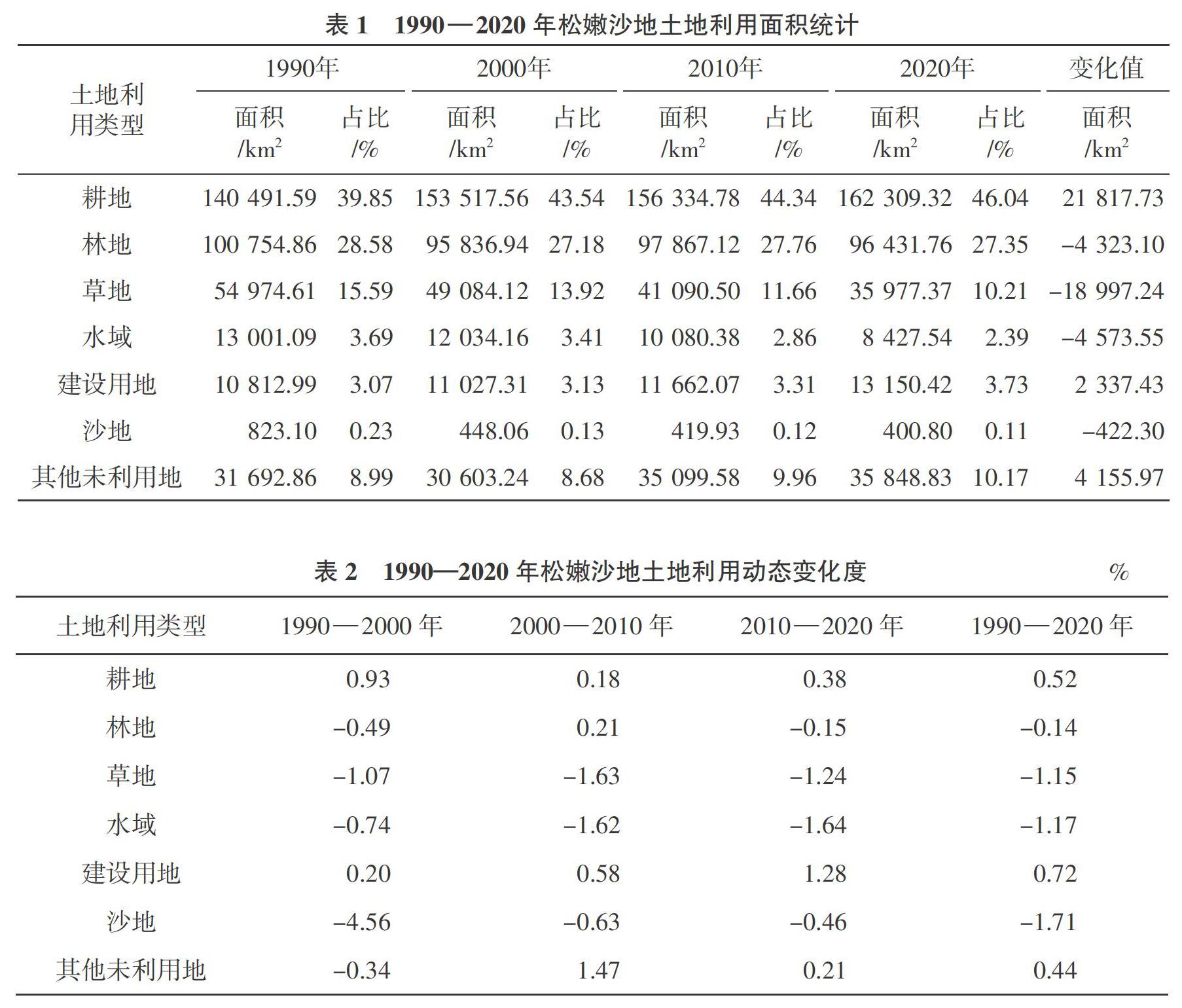
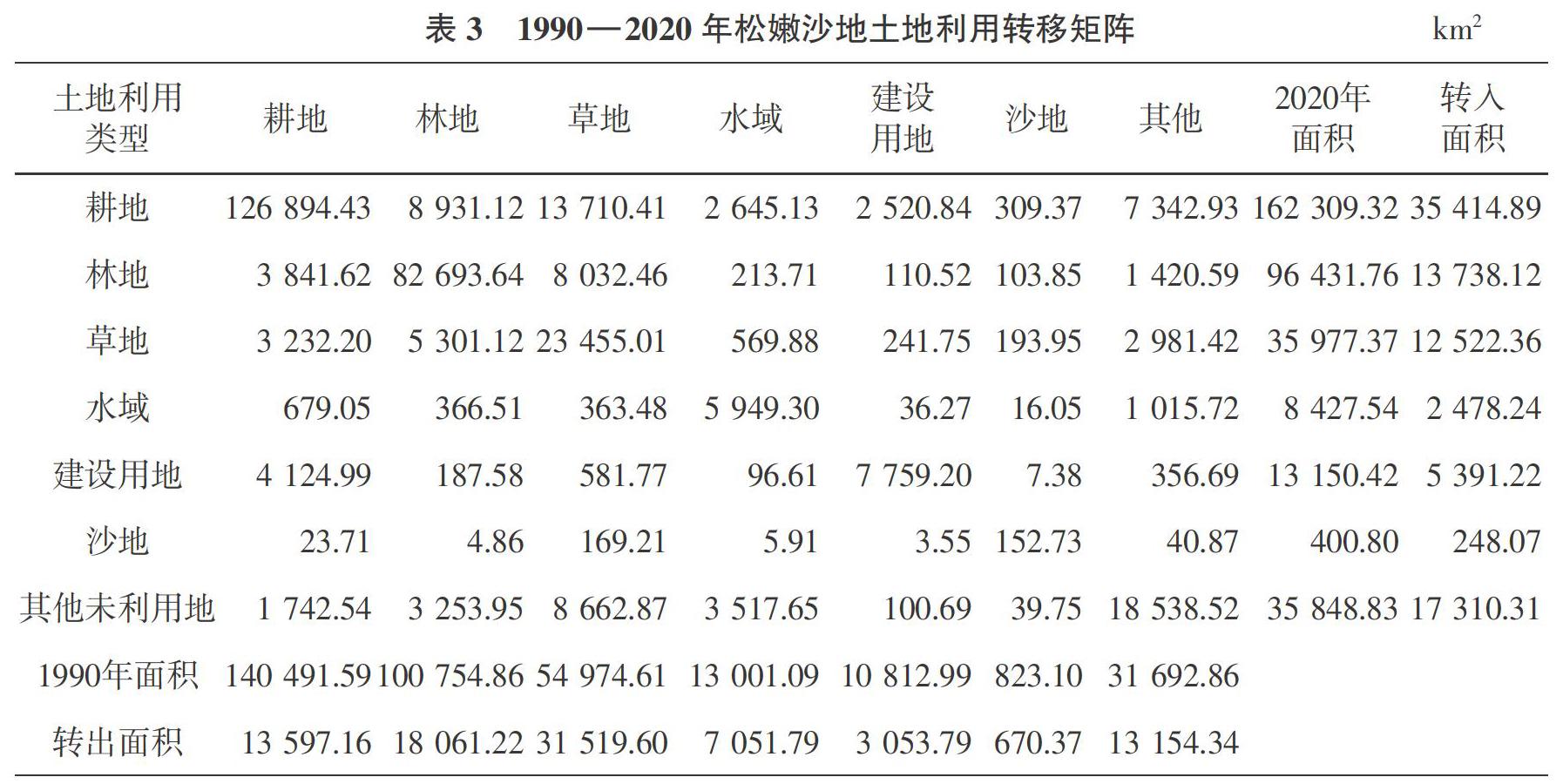
摘要:以松嫩沙地1990年、2000年、2010年、2020年4期土地利用数据为基础,分析该区 1990 — 2020年期间土地利用变化特征。结果表明,空间格局上,耕地面积最多,2020年耕地总面积达162 309.32 km2,占研究区总面积的46.04%;其次为林地,2020年林地总面积 96 431.76 km2,占研究区总面积的27.35%。从土地利用变化角度看,建设用地面积逐渐增加,共增加了2 337.43 km2,且建设用地的增加大都是由耕地转化而来。
关键词:土地利用变化;遥感;松嫩沙地
中图分类号:F301.2 文献标志码:A 文章编号:1001-1463(2021)07-0045-05
doi:10.3969/j.issn.1001-1463.2021.07.009
Abstract:Based on the land use data of 1990, 2000, 2010 and 2020 in Songnen sandy land, this paper analyzes the characteristics of land use change from 1990 to 2020. The results showed that in terms of spatial pattern, the cultivated land area is the largest, with a total area of 162 309.32 km2 in 2020, accounting for 46.04% of the total area of the study area, followed by forest land, with a total area of 96 431.76 km2 in 2020, accounting for 27.35% of the total area of the study area. From the perspective of land use change, the area of construction land increased gradually, with a total increase of 2 337.43 km2, and most of the increase of construction land came from the conversion of cultivated land. The research results can provide a scientific basis for the sustainable development of land use in this area.
Key words:Land use change;Remote sensing;Songnen sandy land
土地利用变化受自然和人文因素的影响,自然因素在一定程度上对土地利用变化起作用,如气温、降水、光照和风速等;而各种人文因素也对土地利用变化有一定影响,如社会、文化、技术、经济、和政策 等[1 ]。土地利用变化是研究全球变化的热点问题之一,研究土地利用变化的内部驱动力和外部驱动力是核心问题[2 ]。土地利用变化不仅可以为资源环境保护和可持续发展提供决策基础,还能够为区域经济协调发展提供理论依据。杨佳佳等[3 ]基于1985年、2000年和2017年3期土地利用遥感监测数据,利用土地利用转移矩阵、重心模型和生态环境质量指数等方法,对松嫩平原东部30年间土地利用转型时空变化特征及生态环境效应进行分析。Arefin等[4 ]以1955 — 2016年间孟加拉国帕德玛河的河流变迁作为研究对象,利用地理信息系统和遥感技术对土地利用的相关影响进行评估。童威等[5 ]为探究武汉市土地利用时空变化特征,基于Landsat遥感影像数据,从土地利用动态度和土地利用状态指数两个方面分析了武汉市2000 — 2019年的土地利用时空变化格局。……