海岸建筑退缩线的综合划定体系
2021-08-20王刚张甲波白玉川杨燕雄黄哲刘会欣肖桂珍
王刚 张甲波 白玉川 杨燕雄 黄哲 刘会欣 肖桂珍

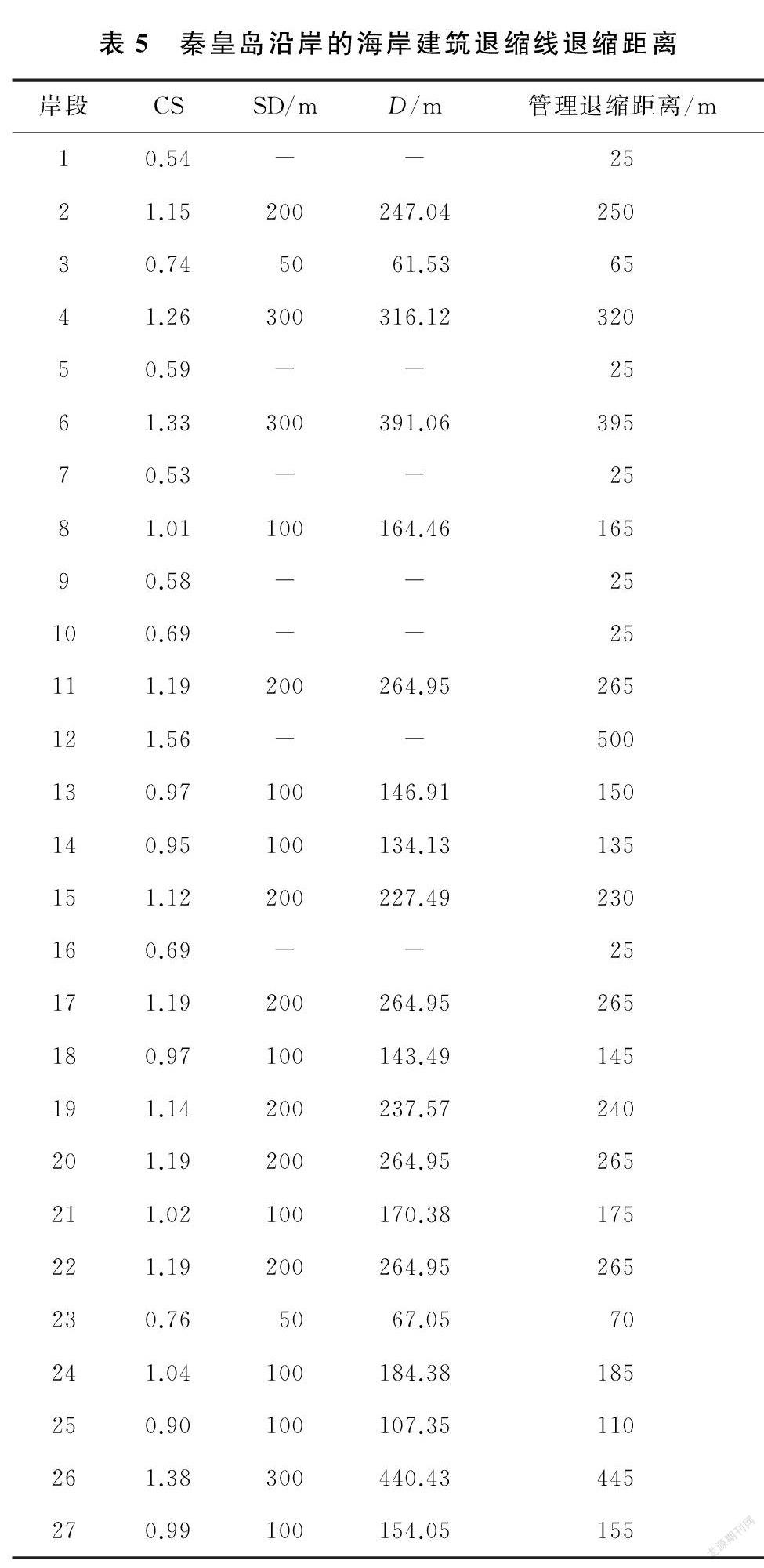
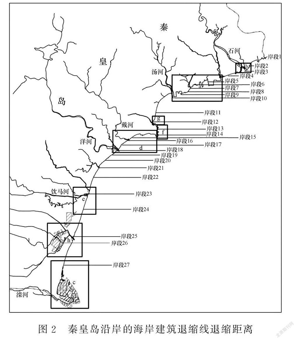
摘要:海岸建筑退缩线是科学有效保护和管理海岸线的重要措施之一。为促进我国海岸线资源的可持续开发利用 , 文章兼顾海岸线的自然和社会等属性 , 采用德尔菲法、层次分析法和聚类分析法相结合的方法 ,构建我国海岸建筑退缩线退缩距离的综合评价指标体系 , 提出退缩距离的计算方法 , 并以秦皇岛沿岸为例划定海岸建筑退缩线。研究结果表明:海岸建筑退缩线退缩距离的综合评价指标体系包括海岸线类型、海岸线开发利用类型、海洋经济效益、防灾效果和生态环境质量5类影响因素以及16项主要指标;在确定退缩线起算基线、综合评价指标分级和退缩距离等级的基础上 , 海岸建筑退缩线退缩距离是随综合评价值的增大而敏感性增强的连续分段函数;在秦皇岛沿岸的27个岸段中 , 海岸建筑退缩线的退缩距离等级分布较广 , 最小和最大退縮距离分别为25m 和500m ,其中河口和基岩等岸线的退缩距离较小 , 旅游娱乐岸线的退缩距离基本为200~300m ,保护区岸线的退缩距离较大。
关键词:海岸线;退缩线;海岸建筑;退缩距离;陆海统筹
中图分类号:P748;P753 文献标志码:A 文章编号:1005-9857(2021)12-0058-09
Comprehensive Delineation of the Coastal Building Setback Line:A Case Study in Qinhuangdao, China
WANG Gang1.2.3,ZHANG Jiabo2.3,BAI Yuchuan1,YANG Yanxiong2.3,
HUANG Zhe1,LIU Huixin2.3,XIAO Guizhen4
(1.Tianjin University,Tianjin 300000,China;
2.Marine Geological Resources Survey Center of Hebei Province, Qinhuangdao 066000,China;
3.Marine Ecological Restoration and Smart Ocean Engineering Research Center of Hebei Province, Qinhuangdao 066000,China;
4.Department of Natural Resources of Hebei Province,Shijiazhuang 050000,China)
Abstract:Coastal building setback line is a key way to protect and manage the coastlines. To promote sustainable development and utilization of coastline resources in China, this paper established an comprehensive evaluation index system, which balanced natural and social attributes ofthe coastline, and provided a calculate method to assess the distance of coastal building setbackline based on expert opinion method (Delphi), analytic hierarchy process (AHP) and cluster analysis. Moreover, this method was used to establish the coastal building setback line in Qinhuangdao. The results showed that 5 factors, i.e. coast type, coastline using type, marine economic benefits, disaster prevention intensity and ecological environment quality, which contained16 indicators were property to establish the comprehensive evaluation index system of thedistance of coastal building setback line. According to our evaluation system, when the startingbaseline of setback line, grade of comprehensive evaluation index and grade of setback distancewere determined, the coastal building setback distance was a continuous piecewise function andthe sensibility of it increased with the enhancement of the value of comprehensive evaluation.Meanwhile, 27 segmented shorelines in Qinhuangdao had different grades of coastal building setback, of which the minimum setback distance was 25 m and the maximum was about 500 m. Fordetails, the shoreline types of estuary and bedrock were with relative short setback distances,while the setback distance of recreational shoreline ranged from 200 m to 300 m. The shoreline ofconservation area was with longer setback distance compared to others.
Keywords:Coastline,Setback line,Coastal building,Setback distance,Land-sea coordination
0 引言
海岸带作为独特的资源具有脆弱性和敏感性 ,随着海洋经济的发展、人口的增长和城市化建设的加快 ,人类对海岸带资源的开发利用程度逐渐增强 ,越来越多的人工建筑物占用海岸线空间资源且距离海水越来越近[1-2] , 给海岸带生态环境带来巨大压力 , 同时受到台风和风暴潮等海洋灾害的潜在威胁[3-4]。……
