祁连山自然保护区祁丰林区森林土壤电导率和盐分含量
2021-06-22石澎雨石晓萍侯玉梅车宗伟
石澎雨 石晓萍 侯玉梅 车宗伟


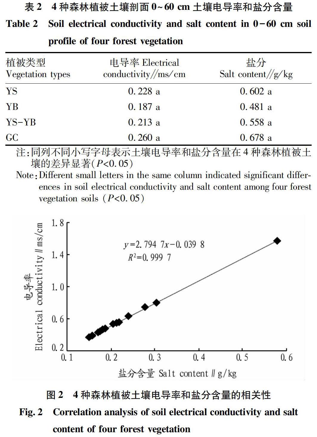
摘要 在祁连山自然保护区祁丰林区分布的4种典型森林植被采集土样,采用电极法和质量法对其电导率和盐分含量进行测定分析。结果表明:4种森林植被土壤中的电导率和盐分含量变化规律各不相同,其中青海云杉林和祁连圆柏林土壤剖面不同土层的差异不显著(P>0.05),而青海云杉-祁连圆柏混交林和灌木林土壤剖面40~60 cm土层显著高于其他土层(P<0.05)。青海云杉林、祁连圆柏林、青海云杉-祁连圆柏混交林和灌木0~60 cm土层的土壤电导率和盐分含量分别为0.228、0.187、0.213、0.260 ms/cm和0.602、0.481、0.558和0.678 g/kg,4种森林植被土壤未发生盐渍化现象。另外,4种森林植被土壤电导率(y)和盐分含量(x)之间的回归方程为y=2.794 7x-0.039 8(R2=0.999 7,P<0.01)。
关键词 土壤养分;土壤电导率;土壤盐分;祁丰林区
中图分类号 S153.3 文献标识码 A
文章编号 0517-6611(2021)09-0127-03
doi:10.3969/j.issn.0517-6611.2021.09.032
Abstract Soil samples were collected from four typical forest vegetation in Qifeng forest area of Qilian Mountain Nature Reserve.The electrical conductivity and salt content were measured and analyzed by electrode method and mass method.The results showed that the electrical conductivity and salt content in soil of four forest vegetation were different.Among them, the difference between the different soil layers of Picea crassifolia Kom.forest and Sabina przewalskii forest soil profile was not significant (P>0.05), while the 40-60 cm soil layer of P.crassifolia-S.przewalskii forest and shrub forest soil profile is significantly higher than other soil layers ( P<0.05).The average soil conductivity and salt content of P.crassifolia forest,S.przewalskii forest,P.crassifolia-S.przewalskii mixed forest and shrubs at the depth of 0-60 cm were 0.228,0.187,0.213, 0.260 ms/cm respectively and 0.602,0.481,0.558 and 0.678 g/kg.No salinization occurred in the soil of 4 forest vegetation.In addition, the regression equation between soil conductivity (y) and salt content (x) of the four forest vegetations was: y=2.794 7x-0.039 8 (R2=0.999 7, P<0.01).
Key words Soil nutrients;Soil conductivity;Soil salinity;Qifeng forest region
土壤鹽分含量是评价土壤是否发生盐渍化或盐渍化严重程度的重要指标[1],土壤电导率与土壤盐渍化具有较高的相关性[2-3],通过电导率的测定可在一定程度上表征土壤中盐分含量。不同土地利用类型的土壤盐分具有不同的分布和迁移特征[4],如贡璐等[5]研究发现,塔里木河上游阿拉尔垦区土壤表层的盐分含量大于心土层和底土层,表层盐分含量表现为盐碱地>天然林>人工林>荒草地>撂荒地>耕地>新开耕地。分布在干旱、半干旱地区山地森林土壤水分的唯一来源是大气降水,而且因林冠截留输入的降水更稀少,加上气温较高土壤蒸发量大,土壤中的可溶性盐在水分和蒸发等外力的作用下,迁移到地表而积累,在一定程度上造成土壤盐渍化,森林植被生长受到限制,从而影响森林生态系统的稳定性。分布在祁连山西段的森林植被大气降水少、气温高[6],然而,有关于在该气候条件影响下的森林土壤电导率和土壤盐分在土壤剖面上的分布规律,不同植被类型间的含量差异以及土壤电导率和盐分的关系等鲜有报道。鉴于此,笔者选择……