基于时间序列遥感影像的广西南流江口海岛变迁研究
2020-09-10杨帆高奕康边启明王增军王娜温玉波
杨帆 高奕康 边启明 王增军 王娜 温玉波
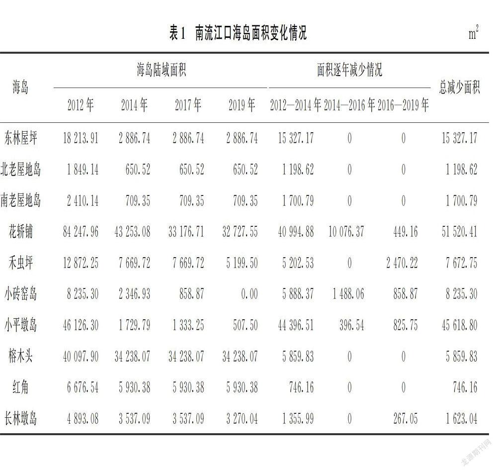
摘要:广西南流江口无居民海岛生态系统较为脆弱,自海岛地名普查以来,该区域海岛形态和岛体开发利用变化显著。文章基于2012—2019年共8期遥感影像,开展南流江口海岛形态和开发利用的遥感提取和变化检测,并逐年分析海岛变化情况。遥感监测结果表明:2012—2019年,南流江口10个海岛形态变化显著,面积减少约61.8%,2个海岛岛体新增开发利用变化;重点说明花轿铺、小砖窑岛和小平墩岛3个显著变化海岛的逐年变迁情况,并分析海岛变迁的主要原因,为海岛保护和管理提出若干建议。
关键词:遥感监测;海岛形态;海岛开发利用;海岛变迁
Abstract:The ecosystem of island in Nanliujiang Estuary in Guangxi is relatively fragile,the islands had significant changes in morphology and island development and utilization since the investigation of islands in 2012.Based on the 8 phase remote sensing images from 2012 to 2019,the paper conducted remote sensing extraction and change detection of the morphology and island development and utilization of the Nanliujiang Estuary Islands,and analyzed the island changes in every year.The remote sensing monitoring results showed that from year 2012 to 2019,the morphology of the 10 islands had changed significantly with an area of about 61.8% reduction,and new development and utilization changes in 2 islands.The paper focused on the year-to-year changes of the islands named Huajiaopu,Xiaozhuanyao and Xiaopingdun.The paper analyzed the main reasons for the change of the island,and put forward several suggestions for the protection and management of the island.
Key words:Remote sensing monitoring,Island morphology,Island exploitation,Island dynamical changes
0 引言
海洋是人類生存与发展的基本环境和重要资源保障,是人类可持续发展的重要支撑。海岛是地球上环境复杂、生态脆弱、灾难较多的区域之一,自21世纪以来,我国海岛开发进入快速发展时期,人类对海岛及周边海域的开发和利用程度也空前提高,生态环境则日渐脆弱。对生态环境较为脆弱的无居民海岛开展保护和管理,妥善协调无居民海岛开发利用与生态保护的关系,对维护国家海洋权益、发展海洋经济、保障国防安全尤为重要。
江河入海口海岛是重要的海洋生态系统,但位于河海交界处,受河流冲刷和海洋潮汐作用双重影响,生态系统极其脆弱。因此,开展河口海岛的动态监视监测,对于及时掌握海岛变化和及时制定海岛保护修复措施具有重要意义。……
