云南省气温和降水变化特性研究
2020-09-10张楠
张楠
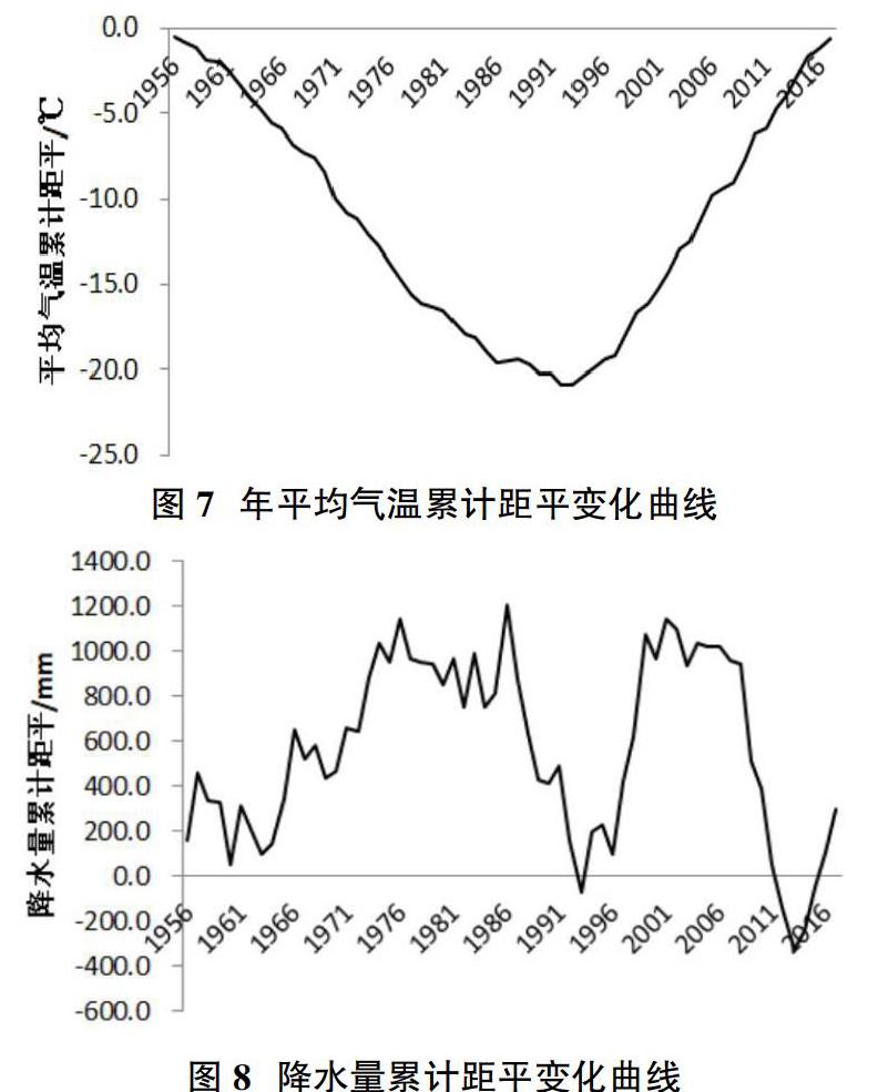
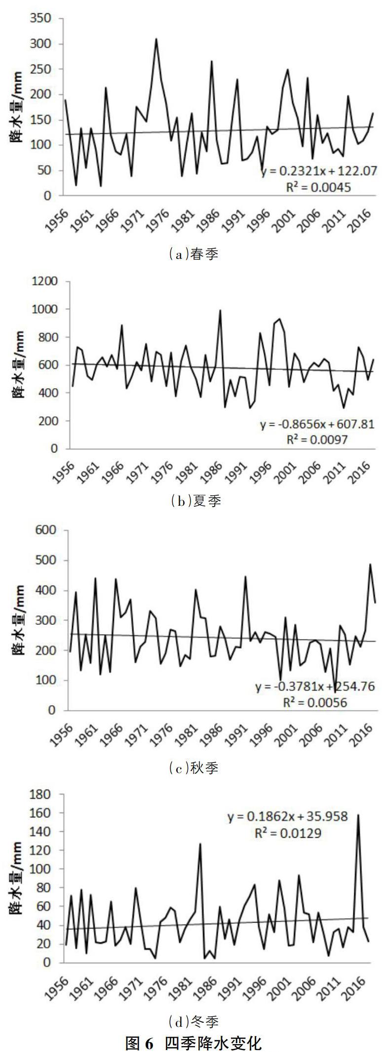
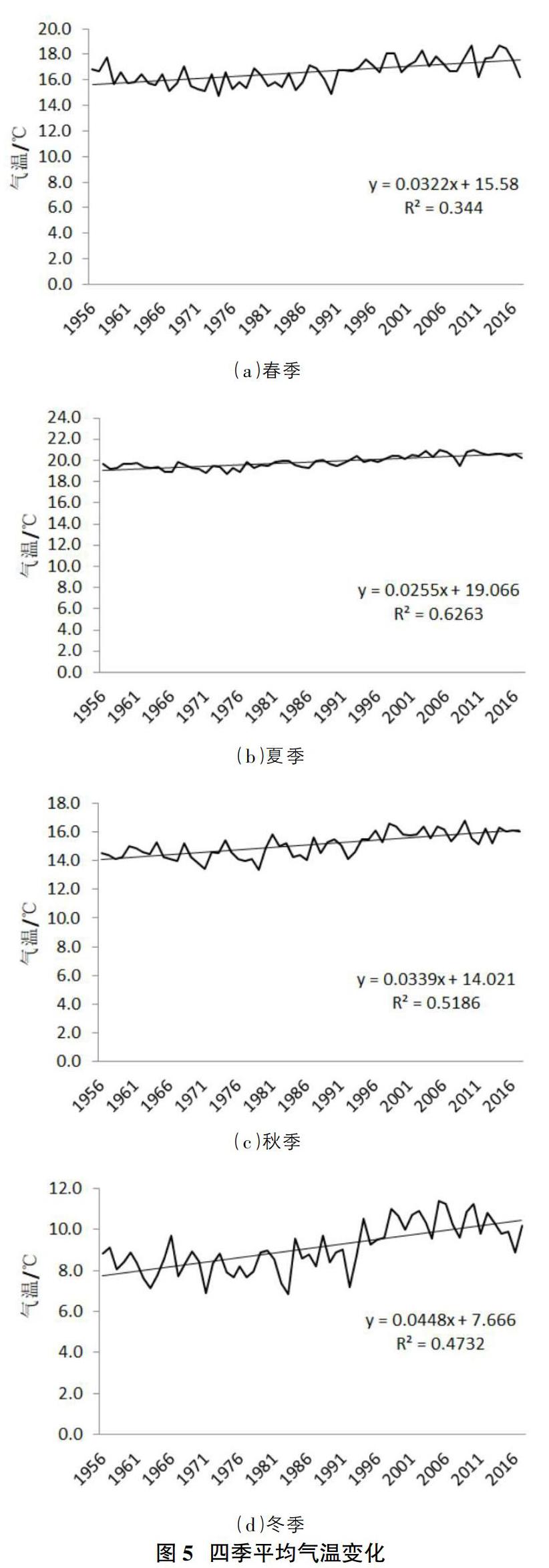
摘要:利用云南国家9个气象站观测1956-2017年的气温和降水资料,采用线性回归分析,趋势线分析、累积距平统计量与信噪比检验方法,对62年来的气温和降水变化进行特性分析。结果表明:云南省年平均气温呈现逐年增加的趋势,降水量都出现逐年减小的趋势,不考虑量纲差异,其降低速率具有反向相关性,大致年平均气温每升高1℃,年降水量减少24.2mm。四季气温均呈现稳步上升趋势,其中夏季气温升高最为显著,四季降水量变化表现为春、冬两季降水量有所增加,夏、秋两季降水量有所减小。
Abstract: The temperature and precipitation data from 1956 to 2017 were observed at 9 national weather stations in Yunnan province, and the characteristics of temperature and precipitation changes over 62 years were analyzed by using linear regression analysis, trend line analysis, cumulative anomaly statistics and signal-to-noise ratio test methods. The results show that the annual average temperature in Yunnan province shows a trend of increasing year by year, and the precipitation shows a trend of decreasing year by year. Regardless of dimensional differences, the decreasing rate is inversely correlated, and the approximate annual average temperature decreases by 24.2mm for every 1℃ increase. The temperature in all four seasons showed a steady trend of rise, among which the temperature in summer was the most significant. The change of precipitation in the four seasons showed that the precipitation in spring and winter increased, while the precipitation in summer and autumn decreased.
關键词:气温;降水;季节变化;年际变化
Key words: temperature;precipitation;seasonal changes;interannual variability
中图分类号:P333 文献标识码:A 文章编号:1006-4311(2020)25-0241-04
1 研究背景
云南省地处中国南部,属青藏高原南延部分,平均海拔2000米左右。地形上常常以元江谷地和云岭山脉中的宽谷为界,将其划分成东、西两大地形区。东部称为滇东、滇中高原,地形波状起伏,表现为起伏和缓的低山和浑圆丘陵,岩溶广泛发育。西部为横断山脉纵谷区,高山深谷相间,相对高差较大,地势险峻。云南地处低纬高原,地形地貌复杂,气候类型多变,雨量较为充沛,但是每年都会出现不同程度的干旱,这种湿润地区的临时干旱特点对农业及工业有很大的影响[1-4]。同时随着全球气候变暖及极端天气的增多,探究云南省的气温和降水量是否有与全球气候变暖趋势一致这一问题,对社会生产和经济建设都有着及其重要的意义。
本文以来自空间离散分布的气象台站的气候数据资料,研究了云南地区气候条件随时间发生的变化。……