季节性冻融区井渠结合灌域地下水动态预报
2017-03-27杨文元郝培静刘佳帅杨金忠
杨文元,郝培静,朱 焱,刘佳帅,于 健,杨金忠
季节性冻融区井渠结合灌域地下水动态预报
杨文元1,郝培静1,朱 焱1,刘佳帅1,于 健2,杨金忠1※
(1. 武汉大学水资源与水电工程科学国家重点实验室,武汉 430072; 2. 内蒙古自治区水利科学研究院,呼和浩特 010020)
该文以河套灌区永济灌域为研究对象,建立考虑冻融影响的分段式水均衡模型,预报12种井渠结合节水情景的地下水动态响应。结果表明:冻融期间气温对地下水埋深的影响在时间上滞后46.5 d,两者相关关系明显;地下水开发利用越多、秋浇采用黄河水的比例越小,节水规模越大,同时地下水位下降越明显。12种节水情景中,节水规模占现状引水量的5.7%~15.5%,全灌域平均地下水埋深增加0.05~0.24 m,井渠结合区地下水埋深增加0.16~0.38 m;灌域引黄水量与地下水埋深关系用二次函数进行拟合,决定系数2达到0.88以上;灌溉水利用效率的提高以及地下水位下降引起潜水蒸发的减小是井渠结合节水的实质。分析结果表明,考虑冻融影响的水均衡模型简单实用,可为中国西北干旱半干旱地区开展井渠结合地下水响应预报提供参考。
灌溉;节水;地下水;水均衡模型;动态;季节性冻融区
0 引 言
农业用水占黄河流域用水量的80%,是流域内最具节水潜力的环节[1]。井渠结合能提高水资源利用率,减少无效潜水蒸发,是减少农业用水量的有效手段[2-4]。但实施井渠结合同时也会降低地下水位,可能给当地生态系统带来不利影响[5-6]。因此,正确评价井渠结合对地下水系统的影响程度是该节水措施长期稳定运行的关键[7-8]。目前,有关井渠结合的研究基本集中在节水潜力评估[9-10]、地下水承载能力研究[11-13]、井渠结合比例[5,14-15]、地下水地表水联合调度方法[3,16-17]、地下水动态预测方法等[18-21]。但是缺乏对于具有明显冻融期的大型灌区的井渠结合地下水响应定量预报。本文选取河套灌区永济灌域为研究区,建立考虑冻融影响的水均衡模型,反演地下水系统源汇项参数,并预测不同节水情景下地下水动态响应,以期为类似的干旱半干旱地区开展井渠结合提供参考。
1 研究区概况
内蒙古河套灌区是中国最大的“一首制”自流引水灌区。永济灌域位于河套灌区中部,区内面积1 885.34 km2,地势自西南向东北轻微倾斜,平均坡降1/5 000,土地开阔平整。该区域属于典型的温带大陆性干旱、半干旱气候带,多年平均年降雨100~300 mm,水面蒸发量高达1 400 mm/a。全年平均气温7.6~3.7 ℃,由南向北依次递减。最低气温出现在1月份,平均气温−11~−15 ℃;最高气温在7月份,平均月气温20~24 ℃。每年初霜日由东北向西南方向推进,终霜日则正好相反。全年土壤封冻期长达180 d左右,从11月下旬开始冻结,全部融通要到次年5月中旬。土壤冻结厚度1~1.3 m,平均深度约为1.1 m。
区内农业用水几乎全部引自黄河,1990-2013年间引黄水量7.5×10⁸~10.5×10⁸m3/a,呈逐年下降趋势。每年4月中旬开始开闸引水,11月中旬停灌。年内月均灌水量峰值出现在5月春灌和10月秋浇,后者约占全年总引水量的1/3。地下水以潜水为主,少量地势低洼、黏质土覆盖层厚度较大的地区有半承压潜水存在。灌溉是地下水的主要补给来源,其次是降水。地下水排泄途径以蒸发为主,人工开采和沟道排水占比较小,区内地下水循环属于典型的入渗-蒸发类型。
区内水文地质结构,按照埋藏条件与含水层的水文地质特点分为第一含水层组和第二含水层组。第二含水层组埋深较大,与外界水量交换少,且以咸水为主,不适宜开采利用,故本文以第一含水层组为主要研究对象。第一含水层组以冲积湖积相和冲积洪积相为主,至上而下包括全新统、上更新统上组、上更新统下组。全新统以黏性土夹薄层粉细砂为主,含水层薄,水量小,底板埋深20~30 m,为弱含水层。上更新统上组,以冲积湖积层半承压水为主,含水层颗粒粗,砂层厚度大,是具有区域性供水和排水意义的主要含水层,厚度50~120 m,底板埋深80~150 m。上更新统下组,以湖积层承压水为主,含水层颗粒较细,含盐量较高,厚度40~100 m,底板埋深100~250 m。
2 地下水变化机理
将2000-2013年永济灌域44眼观测井5 d间隔地下水埋深数据、1 d间隔灌溉引水数据、月蒸发数据和月降雨数据分别按年份取平均值,汇总如图1所示。
由图1知永济灌域地下水埋深呈季节性变化,按照其主要成因不同,将目标区全年分为冻融期和非冻融期2大时段。冻融期从11月中下旬到次年5月上旬,期间土壤水分迁移过程是各种动力势能综合作用结果[22-25]。冻融期从11月中下旬到次年5月上旬,期间土壤水分迁移过程是各种动力势能综合作用结果[22-25]。11月中下旬后,气温降低,土壤自上而下逐渐冻结,冻结区水势降低,下部高水势地区水分在能量梯度作用下向上补给冻结层,从而导致地下水埋深不断增加,在3月上旬达到全年地下水埋深最大值(约2.7 m);3月份后,气温逐渐升高,土壤冻层由上下2个方向同时向中间融化,融化水下渗,地下水位逐渐升高,直到5月中旬融通为止。在冻融末期,融化水与第1次春灌水的入渗补给使得地下水迅速抬升(最小埋深约1.7 m)。除去不稳定冻结与融化阶段,整个冻融期间,致密的冻结层阻断了地表土壤水分与下层土壤水的水力联系,故地表处土壤蒸发量极小[26]。非冻融期为5月中旬-11月中下旬,入渗与蒸发之间的平衡关系是地下水位埋深变化的主导因素。非冻融期又包括生育期(5中旬-9月)与秋浇期(10-11月中旬)2个阶段,生育期气温高,作物繁盛,腾发量大,总体上潜水蒸发量大于灌溉入渗量,地下水位逐渐下降,直到9月下旬达到最低点(约2.5 m)。秋浇期灌溉水量约占全年的1/3,期间渠系渗漏与田间入渗补给地下水,同时因气温较低,潜水蒸发强度小,地下水补给量远大于潜水蒸发量,导致潜水位迅速上升。秋浇一般于11月上旬结束,此时地下水位达到全年最高值,平均地下水埋深约为1.5 m,局部地区地下水位接近地表。
3 冻融期地下水埋深预测模型
分析冻融期间地下水埋深与气温长系列数据,两者存在明显周期性,可用周期函数表达式分别拟合温度-时间、地下水埋深-时间曲线。地下水埋深数据取2000-2013年(缺少2004、2005年数据)灌域内44眼观测井(5 d观测1次)的平均值,气温数据使用临河气象观测站日数据(1999-2012年)。设定冻融期从12月1日开始,至来年5月31日结束。冻融期温度与地下水埋深埋深变化过程可分别表示为
式中为气温,℃;为时间,d;为地下水埋深,mm;0为各年冻融期地下水埋深初始值(设定为12月1日),mm;0为时间周期,取365 d;α(℃)、βγ(℃)、α(mm)、βγ(mm)均为模型参数。根据式(1)、式(2)和长期观测数据,可得到拟合参数向量为A=[α,,γ]=[16.965 2,0.805,3.755 9],A=[α,,γ]= [−1 050.5,0.004 6,−93.93]。
由于温度在局部时段内相对波动明显,为便于模型求导,将实测温度-时间曲线进行平滑,作为冻融期模型的计算数据。式(1)和(2)周期相同,相位和振幅不同,通过三角变换得到相位差为46.5,说明气温的变化需要滞后46.5 d才能经过土体传导至潜水面。
通过建立温度-地下水埋深的数学表达式(4),可由温度变化推求地下水埋深的变化。与地下水埋深变化直接相关的是46.5 d前的气温值,因此求导利用的气温数据需相对于计算水位时间向前移动46.5 d,取整处理为46 d。
式中H为第天的地下水埋深值,mm;T为第天经过数据平滑后的气温值,℃;0为时间周期,取为365 d;=[α,β,γ]=[−1 050.5,0.004 6,−93.93];A=[α,,γ]= [16.965 2,0.805,3.755 9]。将模型参数带入式(4),经变形可得埋深对温度的导数见式(5),表明冻融期间大气温度每下降(上升)1 ℃,46 d后的地下水埋深将增加(减少)61.87 mm。
由式(4)得到冻融期间日平均地下水埋深与实测埋深对比如图2所示,两者吻合良好,说明该冻融模型针对目标区冻融时段地下水埋深的模拟计算是合理可行的。
注:缺测2004、2005年地下水埋深数据。
Note: Missing observed groundwater depth data in 2004 and 2005.
图2 2000-2013年冻融期地下水埋深计算值与观测值对比
Fig.2 Comparison between calculated and observed groundwater depth in freezing and thawing period from 2000 to 2013
4 水均衡模型率定与验证
4.1 模型构建
水均衡是指研究区多年平均地下水总补给量与总排泄量的平衡关系,即补给水量与排泄水量之差等于地下水储存量的变化量。因其原理简单明确,在大区域地下水模拟中应用广泛[27-29]。均衡方程为
对均衡时段t1~t进行差分离散
得到非冻融期地下水埋深计算模型
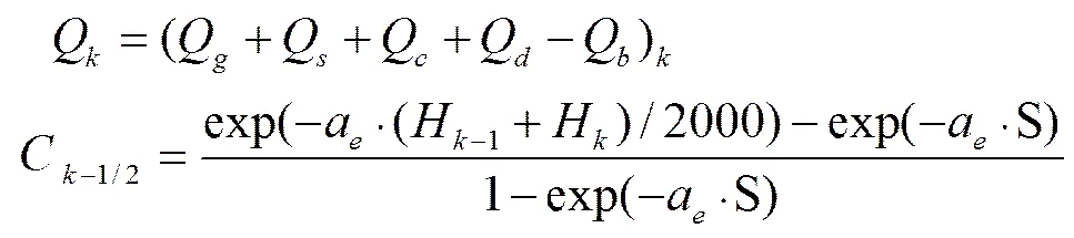
式(6)-(8)中,为给水度;表示人工综合开采水量,mm/d,H为第天的地下水埋深,mm;表示时间;t为第天代表的日期序号;为降雨量,mm/d;为灌溉水量,mm/d;0为水面蒸发量,mm/d;Q为工业地下水用水,Q为生活用水,Q为牲畜地下水用水,Q为排水沟的地下排水,Q为山前侧流和黄河侧渗对地下水补给水量,mm/d;Q、Q、Q、Q、Q以一个综合变量(人工开采量)表示;为极限埋深,mm;α为降雨入渗系数;α为灌溉水入渗系数;C为第天的潜水蒸发系数;α为潜水蒸发参数。
因生育期与秋浇期的土地类型、种植结构和灌溉强度的不同,导致2个时期的水均衡方程虽然形式一致,但对应的水分入渗系数、潜水蒸发系数的取值不同。将非冻融期与冻融期结合起来,构建全年地下水埋深预测模型如式(9)所示。目前,永济灌域实测资料包括5日间隔的地下水埋深资料、1日间隔的引水资料、1月间隔的降雨、蒸发及其他用水资料。将地下水埋深资料线性插值到天,其他降雨、灌溉和引水等资料取各月的日均值。计算时间步长为1 d,以地下水埋深逐日计算值与实测值的差值平方和作为目标函数,采用最小二乘法原理,得到最优参数组合、α、α。
目标函数:
其中:
式中:
式中h为第天末尾时刻的实测地下水埋深,mm;α1、α2分别为生育期与秋浇期降雨入渗系数;α1、α2分别为生育期与秋浇期灌溉水入渗系数。其余参数说明同式(4)-(8)。
4.2 模型率定与验证结果
模型识别采用2000—2010年数据,模型验证采用2011—2012年数据。模型计算得到的逐日地下水埋深与实测数据对比结果见图3,模型率定与验证效果指标见表1,模型参数率定结果见表2。
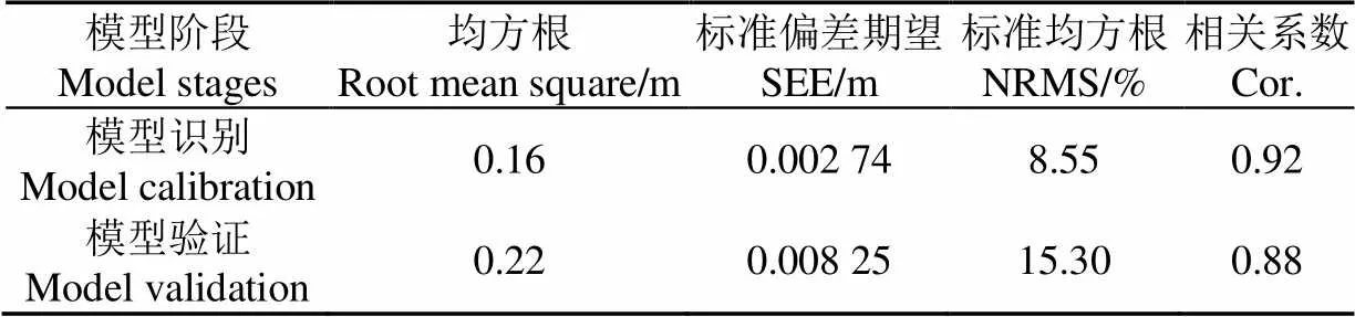
表1 模型率定及验证效果指标
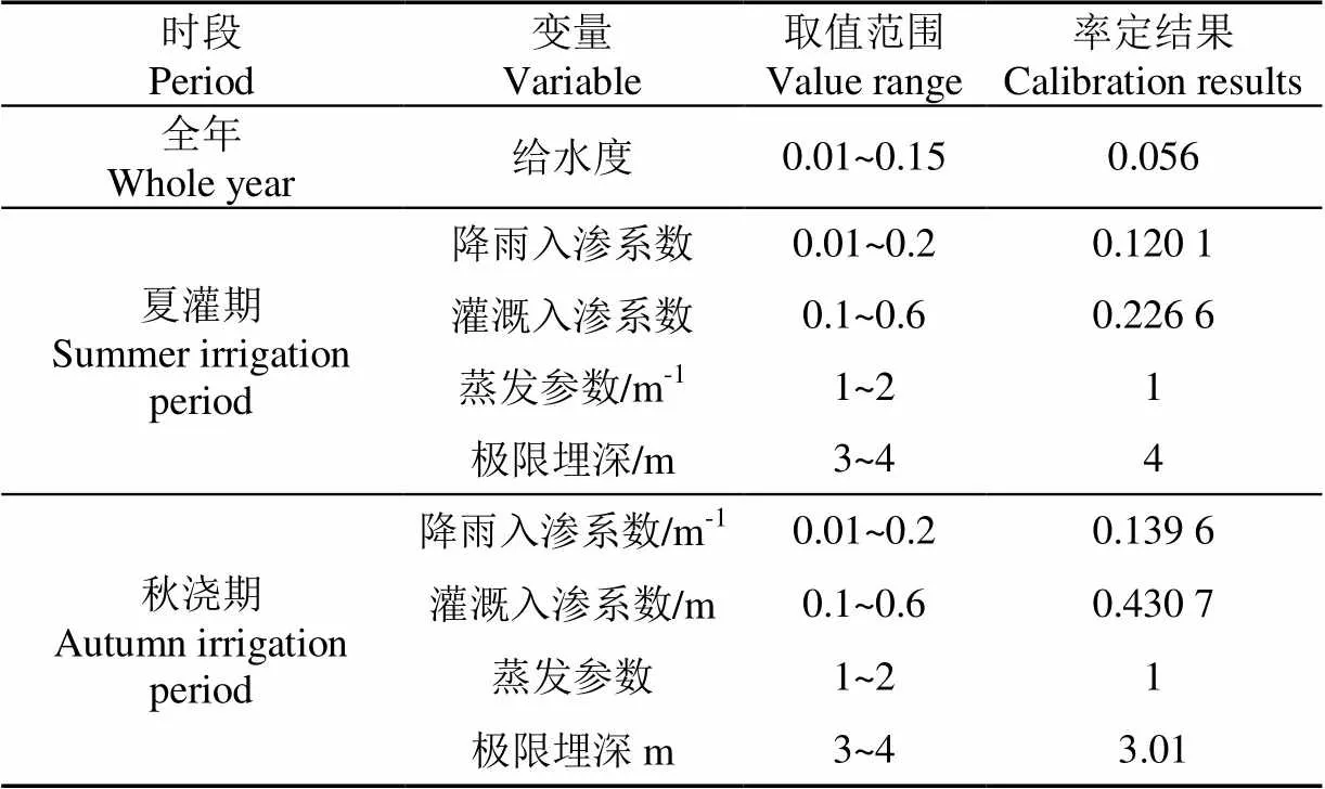
表2 地下水埋深分段模型求参结果
由表1中各参数指标符合要求[22,32],说明该模型可以较好的模拟永济灌域2000-2013年地下水埋深随时间的变化过程。
将率定得到的参数带入潜水蒸发公式,得到各深度下潜水蒸发相对于水面蒸发的折算系数,如图4所示。
表2中,秋浇期入渗系数比生育期大,图4中相同深度下秋浇期潜水蒸发系数比生育期小,原因是秋浇期气温低,大气的蒸发能力减弱,同时作物收割完毕,植株的蒸腾作用消失,秋浇水得以大量补给地下水。在地下水变动最活跃的深度(1.5~3 m),反演得到的蒸发函数与实测值较为接近,具有较高的可信度[30],说明本模型采用的蒸发函数模型是合理可行的。入渗与蒸发是影响地下水埋深变化最重要的两个方面,对于同一种地下水埋深变化情况,可能对应多组入渗与蒸发的组合。为防止此类现象的发生,需掌握尽可能丰富的参考资料,通过限定参数在尽可能小的范围,使反演结果更加合理可靠。结合沙壕渠的实测结果,认为将α范围设置为1~2之间是较为合理的[30]。
5 井渠结合地下水响应预报
5.1 情景假设
根据率定与验证后的地下水均衡模型,预测不同井渠结合节水情景下永济灌域地下水动态响应。井灌区面积根据地下水矿化度数据估算,假设灌域内部土地利用情况基本一致,按照前期研究所确定的井渠结合比1∶2.9的比例[31],地下水灌溉可利用的矿化度上限为2、2.5、3 g/L条件下总可开采面积分别为612.77、904.59、1 098.6 km2,井灌区面积分别为157.12、231.95、281.69 km2。
以2006-2012年数据为预测基础,将井渠结合预测模型时长设置为6 a。假定在预测期内,维持2006-2012年的工业用水、生活用水、牲畜用水等人工开采量不变,气候条件、总灌溉面积、土地利用等情况保持不变,灌溉土地在全区内平均分布,变化仅仅产生于井灌区面积的增加(由渠灌区转换而来)。渠灌区灌溉制度维持现状条件不变,井灌区灌溉制度分为4种情况:井灌区在生育期均抽取地下水进行灌溉,田间灌溉制度与黄灌区相同;秋浇期按照灌溉水源及方式不同分为4种情况:前3种方案在井灌区使用黄河水进行秋浇,频率分别为1、2、3 a一次,平均到各年则相当于100%、50%、33.3%的秋浇面积比例,第4种秋浇方式在井灌区只对来年种植小麦地块进行秋浇(约15%),4种秋浇方案对地下水的开采利用程度依次增强。综上所述,本文共讨论3种矿化度,4种秋浇模式共计12种情景假设(表3)。
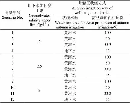
表3 节水情景假设
假设井灌区生育期与秋浇期灌溉回归系数等于已求得的综合入渗系数,则井灌区源汇项在生育期与秋浇期的计算方法如式(10)-(12)所示。
5.2 井渠结合地下水动态响应预测
基于2006-2012年蒸发、降雨、灌溉、气温等数据,分别以全灌域和井渠结合区为水均衡对象,预测两者在井渠结合后不同矿化度条件下各时段地下水平均埋深如图5所示,各节水情景的全灌域和井渠结合区地下水埋深大小关系见表4。
a. 全灌域
a. Whole district
b. 井渠结合区
b. Conjunctive area
注:情景1/5/9:井灌区面积100%引黄河水秋浇;情景2/6/10:井灌区面积50%引黄河水秋浇;情景3/7/11:井灌区面积33.3%引黄河水秋浇;情景4/8/12:井灌区面积15%引地下水秋浇;其余井灌区面积不秋浇,下同。
Note: Scenario 1/5/9: 100% well-irrigated area irrigated with Yellow River water in autumn; Scenario 2/6/10: 50% well-irrigated area irrigated with Yellow River water in autumn; Scenario 3/7/11: 33.3% well-irrigated area irrigated with Yellow River water in autumn; Scenario 4/8/12: 15% well-irrigated area of irrigated with groundwater in autumn; The other well-irrigated area is not irrigated in autumn, Same as below.
图5 全灌域及井渠结合区地下水埋深
Fig.5 Water depth of whole district and conjunctive area
由图5知,相对于现状条件,节水情景1~12的全灌域年平均地下水埋深增加0.05~0.24 m,井渠结合区年平均地下水埋深增加0.16~0.38 m。影响地下水埋深的变化主要为可用于井灌的地下水矿化度利用上限和井灌区秋浇方式。实质上,是以上2因素综合决定了净地下水开采量,进而决定地下水埋深的变化程度。即地下水矿化度利用上限越大,井灌区面积越大,则地下水净开采量越多,进而导致地下水埋深增加越大;井灌区秋浇方式中井灌区采用引黄秋浇的水量越小,或者井水秋浇比例越大,地下水净开采量越大,最终使得地下水埋深增加越大。
由图5b知,井渠结合区平均地下水埋深由井渠结合面积比决定,与矿化度上限(不同矿化度对应不同开发面积)无关。这是由于水均衡模型将井渠结合区整体作为对象,当井渠结合区面积变化时,源汇项随之成比例变化,因此相同井渠面积比条件下,模型计算结果相同。结合区地下水埋深比全灌域平均值明显加大,说明地下水的降落主要发生在井渠结合区,说明秋浇水源对井渠结合区地下水影响较大。故秋浇方式应由节水量、地下水、盐分情况综合分析确定。
5.3 水均衡分析
以全灌域为水均衡分析对象,由于假设降雨为0.267× 10⁸m3/a;融化水为1.238×108m3/a;冻结水为1.17× 108m3/a;非灌溉用途的人工开采量为0.564×108m3/a,且维持不变。变化的水均衡项只有灌溉入渗、蒸发、井灌区开采。全灌域年均引黄水量以公式(13)计算
式中为全灌域全年井渠结合后引黄水量,0指现状条件下全灌域全年引黄水量,Q指现状条件下全灌域秋浇期的引黄水量,m3;0指全灌域总控制面积,S指井灌区灌溉面积,m2;为井灌区黄灌秋浇的面积比例。各方案的引黄水量及变化的均衡项见图6图。各情景水均衡差小于4%,达到精度要求。
图6 不同情景的水均衡项年均值
Fig.6 Annual average water balance items for different scenarios
方案1~12减少引水量为0.483×10⁸~1.326×10⁸m3/a,占现状引水量的5.7%~15.5%,节水效果明显。对比各水均衡项绝对值可知,非冻融期间灌溉入渗是地下水补给的最大来源,,其值为1.772×108~2.123×108m3/a,潜水蒸发是地下水排泄的最主要途径。其值为1.354×108~1.729×108m3/a井渠结合导致的潜水蒸发减小水量是节水潜力的最大来源,潜水蒸发减少量可达到0.108×108~0.374×108m3/a。各情景中,蒸发减小量均大于地下水开采增加量,因此可以满足井灌区地下水可持续开采需求。井渠结合节水的实质是减少无效潜水蒸发,提高水资源利用效率,从而减少引黄水量。
5.4 引黄水量与地下水埋深关系
将现状条件与12种情景假设下的全灌域引水量与全灌域各时段平均地下水埋深利用二次多项式进行拟合(图7),决定系数2均在0.88以上,运用F检验得到的值在10-8~10-6的量级,说明两者存在强相关关系。生育期地下水埋深与引水量回归效果最好,因为该时段灌域地下水埋深近乎完全由引水量大小决定。冻融期的决定系数2相对较小,则是因为该时期已经停灌,主导地下水埋深变化的因素,除了秋浇后的初始地下水埋深外,气温起主导作用。秋浇期回归效果位于中间,因为11月中下旬处于非冻融期与冻融期交界的时段。通过回归分析得到引黄水量与地下水埋深的关系式,可以为目标区乃至类似的干旱半干旱地区开展井渠结合提供简单快捷的地下水埋深预测方法。
6 结论与展望
本文根据永济灌域丰富的观测资料,提出了冻融期地下水埋深-温度经验模型。在此基础上,构建分段式地下水均衡模型,反演给水度、灌溉、降雨综合入渗系数、潜水蒸发系数等参数。根据率定后的水均衡模型,预测3种矿化度上限、4种秋浇制度共计12种井渠结合情景下的地下水动态响应,为北方具有冻融现象的干旱半干旱灌区开展井渠结合提供参考。
1)开展井渠结合后,全灌域年平均地下水埋深增加0.05~0.24 m,井渠结合区年平均地下水埋深增加0.16~0.38 m。节水规模越大,地下水降落越明显。
2)12种方案节水规模占现状引水量(8.54×10⁸m3/a)的5.7%~15.5%,灌溉入渗水量减少0.073×108~0.350× 108m3/a,潜水蒸发减少0.108×108~0.374×108m3/a,井灌区开采量增加0.133×108~0.238×108m3/a。井渠结合节水的实质是减少无效潜水蒸发,提高水资源利用效率。
3)根据不同情景得到灌区引水量与地下水埋深之间可以用二次函数的简易函数形式表达,决定系数R达到0.88以上。
水均衡模型对于大区域地下水响应的研究优势在于简单有效,但是也有一定局限性。它只能得到研究区的平均地下水埋深,不能体现研究区内部埋深的差别。另外,本文采用情景分析法评价灌区井渠结合后地下水响应,考虑的影响因素存在概化与假设。在实际生产过程中,还需要根据各方面的信息综合确定合适方案,并对实施效果进行跟踪评价,以形成实时响应的决策系统。
致谢:本研究得到内蒙古自治区水利科技计划项目(2014-117)的资助,在资料收集和野外试验过程中得到内蒙古农业大学屈忠义教授、孙贯芳硕士和义长灌域管理局张武军工程师的协助。
[1] 陈亚新,屈忠义,魏占民,等. 大型灌区节水改造后农田水环境变化预测研究[M]. 北京:中国农业科学技术出版社,2007.
[2] 沈荣开,张瑜芳,杨金忠. 内蒙河套引黄灌区节水改造中推行井渠结合的几个问题[J]. 中国农村水利水电,2001,2:16-19.
[3] Williamson R, Lachenbruch C, Vangilder C. An integrating approach for conjunctive-use planning of surface and subsurface water system[J]. Water Resources Management, 2011, 25(1): 59-78.
[4] Zhang Xiaodong. Conjunctive Surface Water and Groundwater Management under Climate Change[J]. Frontiers in Environmental Science, 2015, 3(1): 1-10.
[5] 李萍,魏晓妹,降亚楠,等. 关中平原渠井双灌区地下水循环对环境变化的响应[J]. 农业工程学报,2014,30(18): 123-131.
Li Ping, Wei Xiaomei, Jiang Yanan, et al. Response of groundwater cycle to environmental changes in Guanzhong Plain irrigation district[J]. Transactions of the Chinese Society of Agricultural Engineering(Transactions of the CSAE), 2014, 30(18): 123-131. (in Chinese with English abstract)
[6] 李平,齐学斌,黄仲冬,等. 渠井用水比对灌区降水响应及其环境效应分析[J]. 农业工程学报,2015,31(11):123-128.
Li Ping, Qi Xuebin, Huang Zhongdong, et al. Response of precipitation to ratio of canal to wells and its environmental effects analysis in combined well-canal irrigation area[J]. Transactions of the Chinese Society of Agricultural Engineering (Transactions of the CSAE), 2015, 31(11): 123-128. (in Chinese with English abstract)
[7] 冯绍元,马英,霍再林,等. 非充分灌溉条件下农田水分转化SWAP模拟[J]. 农业工程学报,2012,28(4):60-68.
Feng Shaoyuan, Ma Ying, HuoZailin, et al. Simulation study of field water transformation under deficit irrigation with SWAP model[J]. Transactions of the Chinese Society of Agricultural Engineering(Transactions of the CSAE), 2012, 28(4): 60-68. (in Chinese with English abstract)
[8] 康绍忠,胡笑涛,蔡焕杰,等. 现代农业与生态节水的理论创新及研究重点[J]. 水利学报,2004,35(12):1-7.
Kang Shaozhong, Hu Xiaotao, CaiHuanjie, et al. New ideas and development tendency of theory for water saving in modern agriculture and ecology[J]. Journal of Hydraulic Engineering, 2004, 35(12): 1-7. (in Chinese with English abstract)
[9] 阮本清,韩宇平,蒋任飞,等. 生态脆弱地区适宜节水强度研究[J]. 水利学报,2008,39(7):809-814.
Ruan Benqing, Han Yuping, Jiang Renfei, et al. Appropriate water saving extent for ecological vulnerable area[J]. Journal of Hydraulic Engineering, 2008, 39(7): 809-814. (in Chinese with English abstract)
[10] 谭秀翠,杨金忠. 石津灌区地下水潜在补给量时空分布及影响因素分析[J]. 水利学报,2012,43(2):143-152.
Tan Xiucui, Yang Jinzhong. Temporal and spatial distribution of the potential recharge and influencing factors in Shijin Irrigation District[J]. Journal of Hydraulic Engineering, 2012, 43(2): 143-152. (in Chinese with English abstract)
[11] 张光辉,费宇红,刘春华,等. 华北平原灌溉用水强度与地下水承载力适应性状况[J]. 农业工程学报,2013,29(1):1-10.
Zhang Guanghui, FeiYuhong, Liu Chunhua, et al. Adaptation between irrigation intensity and groundwater carrying capacity in North China Plain[J]. Transactions of the Chinese Society of Agricultural Engineering(Transactions of the CSAE), 2013, 29(1): 1-10. (in Chinese with English abstract)
[12] 王建莹,张盼盼,刘燕. 泾惠渠灌区地下水位动态与灌溉农业的关系[J]. 干旱地区农业研究,2016,34(1):247-251.
Wang Jianying, Zhang Panpan, Liu Yan. Relationship between groundwater level and irrigated agriculture in Jinghuiqu Irrigation area of China[J]. Agricultural Research in the Arid Areas, 2016, 34(1): 247-251. (in Chinese with English abstract)
[13] 刘燕,朱红艳. 泾惠渠灌区水环境劣变特征及地下水调蓄能力分析[J]. 农业工程学报,2011,27(6):19-24. Liu Yan, Zhu Hongyan. Characteristics of inferior variation of water environment and regulating capacity of groundwater reservoir in Jinghui Canal Irrigation District of China[J]. Transactions of the Chinese Society of Agricultural Engineering(Transactions of the CSAE), 2011, 27(6): 19-24. (in Chinese with English abstract)
[14] 周维博,曾发琛. 井渠结合灌区地下水动态预报及适宜渠井用水比分析[J]. 灌溉排水学报,2006,25(1):6-9.
Zhou Weibo, Zeng Fachen. The Groundwater Level Forecast and the Rational Ratio Analysis for Irrigation District with both Wells and Canals[J]. Journal of Irrigation and Drainage, 2006, 25(1): 6-9. (in Chinese with English abstract)
[15] 代锋刚,蔡焕杰,刘晓明,等. 利用地下水模型模拟分析灌区适宜井渠灌水比例[J]. 农业工程学报,2012,28(15):45-51.
Dai Fenggang, CaiHuanjie, Liu Xiaoming, et al. Analysis of suitable irrigation water ratio of well to channel based ongroundwater model[J]. Transactions of the Chinese Society of Agricultural Engineering(Transactions of the CSAE), 2012, 28(15): 45-51. (in Chinese with English abstract)
[16] 刘平平. 井渠结合灌区水资源联合调控模型研究[D]. 杨凌:西北农林科技大学,2014.
Liu Pingping. Study On a Conjunctive Use Model of Water Resources in Well-canal Combined Irrigation District: A CaseStudy in Jinghuiqu Irrigation District[D]. Yangling: Northwest A&F University, 2014. (in Chinese with English abstract)
[17] 赵振国. 生态友好灌区水资源联合调度研究[D]. 北京:中国农业科学院,2012.
Zhao Zhenguo. Research of Water Resources Management in Irrigation Areas by Taking into account the Eco-friendly[D]. Beijing: Chinese Academy of Agriculture Sciences, 2012. (in Chinese with English abstract)
[18] Emery Coppola Jr, Ferenc Szidarovszky, Mary Poulton, et al. Artificial neural network approach for predicting transient water levels in a multilayered groundwater system under variable state, pumping, and climate conditions[J]. Journal of Hydrologic Engineering, 2003, 8(6): 348-360.
[19] Daliakopoulos I N, Coulibaly P, Tsanis I K. Groundwater level forecasting using artificial neural networks[J]. Journal of hydrology, 2005, 309(1): 229-240.
[20] Sreekanth P, Geethanjali N, Sreedevi P, et al. Forecasting groundwater level using artificial neural networks[J]. Current science, 2009, 96(7): 933-939.
[21] Chen Chingwen, Wei Chihchiang, Liu Hungjen, et al. Application of neural networks and optimization model in conjunctive use of surface water and groundwater[J]. Water Resources Management, 2014, 28(10): 2813-2832.
[22] 李瑞平. 冻融土壤水热盐运移规律及其SHAW模型模拟研究[D]. 呼和浩特:内蒙古农业大学,2007.
Li Ruiping. Study on Soil Water-Heat-Salt Transfer during Freezing-Thawing and Its Simulation by SHAW Model[D]. Huhhot: Inner Mongolia Agricultural University, 2007. (in Chinese with English abstract)
[23] 雷志栋,尚松浩,杨诗秀,等. 地下水浅埋条件下越冬期土壤水热迁移的数值模拟[J]. 冰川冻土,1998,20(1):51-54.
Lei Zhidong, Shang Songhao, Yang Shixiu. Numerical simulation on simultaneous soil moisture and heat transfer under shallow ground water table in winter[J]. Journal of Glaciology and Geocryology, 1998, 20(1): 51-54. (in Chinese with English abstract)
[24] 尚松浩,雷志栋,杨诗秀,等. 冻融期地下水位变化情况下土壤水分运动的初步研究[J]. 农业工程学报,1999,15(2):70-74.
Shang Songhao, Lei Zhidong, Yang Shixiu, et al. Study on soil water movement with changeable groundwater level during soil freezing and thawing[J]. Transactions of the Chinese Society of Agricultural Engineering(Transactions of the CSAE), 1999, 15(2): 70-74. (in Chinese with English abstract)
[25] 王晓巍. 北方季节性冻土的冻融规律分析及水文特性模拟[D].哈尔滨:东北农业大学,2010.
Wang Xiaowei. Study of Soil Freezing and Thawing Law and Simulation of Hydrologic Properties in the Northern SeasonallyFrozen Soil Area[D]. Harbin: Northeast Agriculture University, 2010. (in Chinese with English abstract)
[26] 陈军峰,郑秀清,张永波,等. 季节性冻融期不同潜水位埋深下土壤蒸发规律模拟[J]. 农业机械学报,2015,46(5):131-140.
Chen Junfeng, Zhen Xiuqing, Zhang Yongbo, et al. Simulation of soil moisture evaporation under different groundwater level depth during freeze-thaw period[J]. Transactions of the Chinese Society of Agricultural Machinery, 2015, 46(5): 131-140. (in Chinese with English abstract)
[27] Finch J. Estimating direct groundwater recharge using a simple water balance model–sensitivity to land surface parameters[J]. Journal of hydrology, 1998, 211(1): 112-125.
[28] Welsh W D. Groundwater Balance Modelling With Darcy’s Law[D]. Australian National University, 2007.
[29] Wittenberg H, Sivapalan M. Watershed groundwater balance estimation using streamflow recession analysis and baseflow separation[J]. Journal of hydrology, 1999, 219(1): 20-33.
[30] 王伦平,陈亚新. 内蒙古河套灌区灌溉排水与盐碱化防治[M]. 北京:水利电力出版社,1993.
[31] 王璐瑶,彭培艺,郝培净,等. 基于采补平衡的河套灌区井渠结合模式及节水潜力[J]. 中国农村水利水电,2016(8):18-24.
Wang Luyao, Peng Peiyi, Hao Peijin, et al. Well-canal conjunctive irrigation mode and potential of water-saving amount based on the balance of exploitation and supplement for Hetao Irrigation District[J]. China Rural Water and Hydropower, 2016(8): 18-24. (in Chinese with English abstract)
[32] Xu Xu, Huang Guanhua, Qu Zhongyiet alAssessing the groundwater dynamics and impacts of water saving in the Hetao Irrigation District, Yellow River basin[J]. Agricultural Water Management, 2010, 98(2): 301-313
Groundwater dynamics forecast under conjunctive use of groundwater and surface water in seasonal freezing and thawing area
Yang Wenyuan1, Hao Peijing1, Zhu Yan1, Liu Jiashuai1, Yu Jian2, Yang Jinzhong1※
(1.,,430072,; 2.010020,)
Water resources allocation for agriculture irrigation in the Yellow River basin will be reduced due to water shortage and increasing demand for non-agricultural use. Different measurements should be taken to save water and to ensure the sustainable development of agriculture. The conjunctive use of groundwater and surface water is one of the most promising water-saving measurements by decreasing evaporation and increasing water efficiency. However, it also could result in adverse effects on the local environment such as soil desertification when over-extraction of groundwater occurs. Therefore, it is necessary to estimate the water dynamics accurately when implementing the conjunctive use of groundwater and surface water irrigation in the target district. In this paper, Yongji irrigation sub-area of Hetao irrigation district as the study area to estimate the temporal and spatial groundwater dynamics under the conjunctive use of groundwater and surface water. Yongji irrigation sub-area locates in the arid and semi-arid area, and it has a six months freezing and thawing period from December to May of the next year. The mechanism driving of the groundwater table change in the freezing and thawing period is different from the unfreezing period, with multiple complex impact factors. Temperature is considered as the most important factor to drive the water table change in the freezing and thawing period. An empirical model has been developed in the freezing and thawing period to correlate the groundwater table depth with the air temperature according to the measured date in the past 15 years. The model showed that the water level would drop 61.87 mm with 1℃ decline of the air temperature before 46.5 days ago. This empirical model has been integrated to a water balance model to estimate the groundwater dynamics both in the freezing and thawing period and unfreezing period. The model was then applied in the Yongji irrigation sub-area. Model parameters were calibrated with datasets from 2000 to 2010 and were validated with datasets from 2011 to 2012. Then, the calibrated model was applied to estimate the impacts of conjunctive use of groundwater and surface water under 12 kinds of water saving scenarios. The simulating results indicated that exploitation amount of available groundwater and autumn irrigation amount diverting from the Yellow river were two important factors to impact groundwater table depth. For the 12 scenarios, annual average groundwater level decline in the whole district ranges from 0.05 to 0.24 m. The value ranges of groundwater level decline from 0.16 to 0.38 m in the conjunctive groundwater and surface water irrigation district. The irrigation water diverted from Yellow river accounted for 5.7% to 15.5% of the current water diversion every year. During the unfreezing period, the recharge from irrigation contributes the largest supply to the groundwater aquifer, ranging from 1.772×10⁸to 2.123×10⁸m3/a. The recharge from precipitation ranks secondly to the aquifer with 0.267×10⁸m3/a. The conjunctive use of groundwater and surface water can reduce the phreatic water evaporation as 0.108×10⁸to 0.374×10⁸m3/a. The less phreatic water evaporation and re-use of groundwater were the key points of saving water by the conjunctive use of groundwater and surface water. Meanwhile, the groundwater table depth was closely related with the irrigation water amount. The relationship was described by a quadratic function which could be used as an easy groundwater predicted method when carrying out the conjunctive use of groundwater and surface water. The research results provide important reference to study the groundwater dynamics under the conjunctive use of groundwater and surface water in the similar arid and semi-arid regions.
irrigation; water conservation; groundwater; water balance model; dynamic condition; seasonal freezing and thawing area
10.11975/j.issn.1002-6819.2017.04.020
S151.7
A
1002-6819(2017)-04-0137-09
2016-06-12
2016-07-12
内蒙古自治区水利科技计划重点项目([2014]117)
杨文元,男,重庆人,主要从事地下水、土壤水资源与环境研究。武汉 武汉大学水资源与水电工程科学国家重点实验室,430072。 Email:yangwenyuan@whu.edu.cn
杨金忠,男,河北人,教授(博导)。主要从事地下水及土壤水盐运动的基本理论与应用研究。武汉 武汉大学水资源与水电工程科学国家重点实验室,430072。Email:jzyang@whu.edu.cn
杨文元,郝培静,朱 焱,刘佳帅,于 健,杨金忠. 季节性冻融区井渠结合灌域地下水动态预报[J]. 农业工程学报,2017,33(4):137-145. doi:10.11975/j.issn.1002-6819.2017.04.020 http://www.tcsae.org
Yang Wenyuan, Hao Peijing, Zhu Yan, Liu Jiashuai, Yu Jian, Yang Jinzhong. Groundwater dynamics forecast under conjunctive use of groundwater and surface water in seasonal freezing and thawing area[J]. Transactions of the Chinese Society of Agricultural Engineering (Transactions of the CSAE), 2017, 33(4): 137-145. (in Chinese with English abstract) doi:10.11975/j.issn.1002-6819.2017.04.020 http://www.tcsae.org
