Evolution of Instability before and during a Torrential Rainstorm in North China
2016-08-12LuLIULingkunRANandShoutingGAO
Lu LIU,Lingkun RAN,and Shouting GAO
1Institute ofAtmospheric Physics,Chinese Academy Sciences,Beijing 100029
2Graduate University ofChinese Academy ofSciences,Beijing 100040
3State Key Laboratory ofSevereWeather,Chinese Academy ofMeteorological Sciences,Beijing 100081
Evolution of Instability before and during a Torrential Rainstorm in North China
Lu LIU1,2,Lingkun RAN∗1,and Shouting GAO1,3
1Institute ofAtmospheric Physics,Chinese Academy Sciences,Beijing 100029
2Graduate University ofChinese Academy ofSciences,Beijing 100040
3State Key Laboratory ofSevereWeather,Chinese Academy ofMeteorological Sciences,Beijing 100081
NCEP–NCAR reanalysis datawere used to analyze the characteristicsand evolutionmechanism of convective and symmetric instability before and during a heavy rainfall event thatoccurred in Beijing on 21 July 2012.Approximately twelve hours before the rainstorm,the atmosphere wasmainly dom inated by convective instability in the lower level of 900–800 hPa.The strong southwesterly low-level jetconveyed themoistand warm airflow continuously to the area of torrential rain, maintaining and enhancing the unstable energy.When the precipitation occurred,unstableenergy was released and the convective instability weakened.Meanwhile,due to the baroclinicity enhancement in the atmosphere,the symmetric instability strengthened,maintaining and promoting thesubsequenttorrential rain.Deriving the convective instability tendency equation demonstrated that thebarotropic componentof potentialdivergence and the advection term played amajor role in enhancing the convective instability before the rainstorm.Analysisof the tendency equation ofmoistpotentialvorticity showed that the coupled term of verticalvorticity and thebaroclinic componentof potentialdivergencewas theprimary factor influencing the developmentofsymmetric instability during the precipitation.Comparing theeffectsof these factorson convective instability and symmetric instability showed some correlation.
convective instability,symmetric instability,torrential rain,potentialdivergence
1. Introduction
A torrential rain event occurred over Beijing and Hebei Province in China on 21 July 2012.Being themost severe event of the past 60 years,it attracted great attention.Its strength exceeded expectations,and itcausedmajor lossesof lifeand property.Many researchershaveanalyzed themechanism of this extreme event from different points of view. Sun etal.(2013a)found thatthe train-effectphenomenonwas obvious during the precipitation,and connected itw ith the propagation of an inertial gravity wave.Sun et al.(2013b) explored the effectof the interaction ofmulti-scaleweather systemson the torrential rain overBeijing.Wang etal.(2014) analyzed the water vapor transport features over Beijing. Ran et al.(2014)developed a dynamical element forecast equation w ith themoist thermodynamic advection parameter,the convective vorticity vector,the thermodynam icwaveactivity density,and so on,to predictthe torrential rain.However,thesepreviousstudies focusedmainly on the circulation structure,vapor conditionsormulti-scale interactions,while relatively few studieshaveexam ined thephysicalmechanism of the instability evolution.Strengthening theanalysison the physicalmechanism of instability isimportantand helpful for improving understanding of the generation and development of torrential rain.
Scholars both home and abroad began researching instability and precipitationmany years ago.Charney(1947) and Eady(1949)put forward the idea of baroclinic instability and used it to explain the constant dynam ic instability ofm idlatitude westerly flow.Stone(1966,1970,1971) explored the baroclinic instability in the non-geostrophic atmosphere,and then Hoskins(1974)noted thatsymmetric instability was one of the triggermechanisms for frontal rainfall.Bennetts and Hoskins(1979)found that the perturbation ofmesoscale symmetric instability played a significant role in organizing precipitation.By investigating the relationship between symmetric instability and precipitation,Seltzer etal.(1985)proved thatsymmetric instability wasan importantmechanism for the formation of precipitation.Xu(1986) re-exam ined the linear theory of conditional symmetric instability in a rigorous framework and proposed two types of conditional symmetric instability.Zhang(1988a,b)investigated symmetric instability and transversal instability inbaroclinic basic flow and explored the effectof baroclinicity on ageostrophic inertial flow.Wu etal.(1995),Wu and Cai (1997),Wu and Liu(1999)diagnosed the conditional symmetric instability w ith the moist potential vorticity(MPV) and found that theslantof themoistisentropic surface caused by theenhanced verticalw ind shearor the increased horizontalmoist baroclinic w ind would strengthen the vertical vorticity,thus causing heavy rainfall.Zhang and Zhang(1992) researched the influence of the wave-CISK(conditional instability of the second kind)mechanism on symmetric instability and revealed the feature of symmetric instability perturbation.In the actual atmosphere,convective instability often occurs simultaneously w ith symmetric instability.Seman(1994)proposed the theory of nonlinear convective–symmetric instability.Schultz and Schumacher(1999)reviewed the applicability of symmetric instability to various atmospheric situations.Gao(2000)and Gaoand Zhou(2001) hypothesized thatwhen the horizontalwind shear is strong the shear line becomes the instability of the vortex sheet rather than the traditionalshear instability.Starting from nonlinear equations containing frictional dissipation under the Boussinesq approximation,Lu and Shao(2003)proposed a new type of generalized energy,resulting in a new criterion of generalized nonlinear symmetric instability.Schultz and Knox(2007)explored the relationship between banded convection and a combination of conditional,symmetric and inertial instability.Based on the aforementioned work,the theory of atmospheric instability has been w idely applied to weatheranalysis,and greatprogresshasbeenmade.
Building on previous research,thisstudy aims to explore the characteristicsand evolutionmechanism of instability before and during a precipitation event thatoccurred in Beijing on 21 July 2012,in the hope of providing significant insight for furtherheavy rainfallof a sim ilarnature.Section 2 introduces thebackground situation of the case and the characteristics of the precipitation.Section 3 analyzes the convective and symmetric instability in detail.Section 4 deduces the tendency equation of convective instability and examines the effectof variouselementson the convective instability before the precipitation.Section 5 deduces the tendency equation of symmetric instability and discusses its variation during the precipitation.Section 6 summarizes the key conclusions of the study.
2. An observationaloverview of the squall line and itsenvironment
2.1. Observed precipitation
During the period 21–22 July 2012 a torrentialprecipitation eventoccurred over northern China.The heavy rainfall occurred atabout0200 UTC and had generally vanished by 1800 UTC 21 July.The rain band wasoriented from southwest to northeast(Fig.1).The centerof theprecipitationwas over Beijing(40°N,116°E)and northern Hebei Province, where the 24-h accumulated precipitation reached 200mm. Before 0800 UTC 21 July therewas precipitation generated in the warm region in the front of the front.The center of precipitation scattered.Then,after 0800 UTC 21 July,the frontmoved into the Beijing area,and the scattered center gradually organized into amarked rain band oriented from southwest to northeast.

Fig.1.The 24-h accumulated precipitation(units:mm)from 0000UTC 21 to 0000 UTC 22 July.The black box represents the location of Beijing(39.5°–41°N,115.5°–117.3°E).
In this study,the period before and during the precipitation were both considered to explore the evolution of the instability.
2.2. The background situation
In this study,global forecast system(GFS)reanalysis data from the National Centers for Environment Prediction (NCEP)were used to calculate and explore the spatial and temporal evolution of atmospheric instability and its physicalmechanism.The GFS datawere collected at four times (0000,0600,1200 and 1800UTC),w ith a horizontal resolution of 0.5°×0.5°and a vertical resolution of 26 levels.
The precipitation formed in an environmentw ith awelldefined trough,surface shear line,low-level jet,high-level jet,and sufficientmoisture.At500 hPa(Fig.2a),thewesterly w ind trough was located over Lake Baikal;meanwhile, there were ridges at Barr Kersh Lake(60°–90°E)and eastern Asia,forming a“two ridgeand one trough”environment. The588(gpm)lineof thesubtropicalhigh jumped from 33°N to 36°N,shaping a“high-pressure dam”,which typically favorsan“east-high–west-low”situation fornorthern torrential precipitation.At themomentof the storm’sapproach(0000 UTC 21 July),thewesterly w ind troughmergedw ith another trough overnorthwestern China,moving into northern China. There was a w ide range of southwesterly warm and moist airflow in front of the trough impacting on Beijing(40°N, 116°E)and HebeiProvince.At1200UTC 21 July(Fig.2b), the 588(gpm)line of the subtropicalhighmaintained stability,blocking thewesterly trough from moving eastward,and thus the system was detained over northern China,causing thepersistentprecipitation.

Fig.2.The distribution of(a)geopotentialheightat500 hPa(red line;units:gpm)and w ind vector(units:m s−1)at1200 UTC 20 July;(b)geopotentialheightat500 hPa(red line;units:gpm)and w ind vector(units:m s−1)at0600 UTC 21 July;(c)geopotentialheightat700 hPa(black line;units:gpm),the low-level jetat850 hPa(shaded)and positive relative vorticity(red line;units:10−4s−1)at0000 UTC 21 July;(d)geopotential heightat700 hPa(black line;units:gpm),the low-level jetat850 hPa(shaded)and positive relative vorticity (red line;units:10−4s−1)at0600UTC 21 July;(e)w ind vector(units:m s−1)and the high-level jet(shaded) at200 hPa at1200 UTC 21 July;and(f)relative hum idity(shaded)and w ind vector(units:m s−1)at925 hPa at1200UTC 21 July.
At700hPa,before theheavy rainfall,the low-level trough overnorthwestern Chinamoved eastward alongw ith steering flow.At themomentof the storm’s approach(0000 UTC 21 July),the low-level trough developed intensively and formed a closed vortex.At0600 UTC,the vortexmoved to Beijing. The southwesterly airflow in front of the trough increased, reaching 16m s−1.At1200 UTC 21 July(Fig.2d),the vortex was over the Beijing area and the low-level jet had enhanced,reaching 20m s−1.Beijing was located on the left sideof theexitof the low-level jet.Therewasstrong cyclonic shear and upwardmotion over the Beijing area.At200 hPa (Fig.2f),from 0600 UTC to 1800 UTC 21 July,the Beijing areawasattheentranceof thehigh-level jet,where therewas strong divergence.In accordancew ith the low-level jet,there wasa favorable situation of divergence at the high level,and convergenceat the low level,overnorthern China.
Figure 2g shows the vapor conditions at 850 hPa.The mainwatervaporchannelwas from the Bay of Bengal,transported by a strong southwesterly low-level jet.Furthermore, therewas another channel from the South China Sea,whichwas transported by the southeasterly w ind formed between the tropicalstorm“Vicente”and the subtropicalhigh.These two primary channelsprovided sufficientvapor for theheavy rainfall,causing the Beijing area to be in anearsaturated state fora long time.
3. Instability analysis
3.1. Convective instability
During the period from 0000 UTC 20 to 0600 UTC 21 July(Fig.3)aw ide range of areaw ith an isentropic surface decreased w ith height,whichmeant the convective instability(∂θse/∂p>0)occurred over Beijing(115.5°–117.3°E). The region of strong convective instability extended to 700 hPa.At1200 UTC 20 July(figure omitted),the isolines of pseudo-equivalentpotential temperature(θse)under700 hPa were densewhen the convective instability reached itsmaximum.Meanwhile,there wasweak downward motion over Beijing,so no convection was triggered.At 1800 UTC 20 July(Fig.3a),the convective instability was sustained over Beijing.It isworth noting that therewasan obvious thermal inversion layer at900 hPa,which suppressed the convection and was helpful for accumulating enough unstable energy. When the triggering condition was fulfi lled,the convection occurred and torrential rain poured down.During 0600–1800 UTC 21 July the cold frontmoved across the Beijing area. The convective instability weakened and its height lowered. At the same time,the isentropic surfaces became oriented downward because of the latentheat released,enhancing the θsesuddenly atoneplace;thus,the isentropic surfacebecame concave.At1200 UTC 21 July(Fig.3b)the convective instability decreased and the isentropic surface tilted to almost upright.Beijingwas rightat thebottom of the funnel-shaped isentropic surface.Strong upwardmotion occurred over Beijing,tilted westward w ith height.As shown in Fig.3d,the vertical vorticity increased significantly due to the tilting of the isentropic surface(Wu etal.,1995),causing positive vorticity in thewhole troposphere.The positive vorticity cooperated w ith divergence in theupper leveland convergence in the lower level,bringing about the extreme precipitation.
Figure 3c shows the change over time of the verticalgradientof the pseudo-equivalentpotential temperature and the verticalmotion.From 0000 UTC 20 July a positive region occurred at 900–700 hPa,w ith the strongest center at 900 hPa,whichwas the convective instability.During 0600–1200 UTC 20 July the convective instability reached amaximum. Because therewasno triggering condition active at thismoment,no convection happened.From 0200 UTC 21 July the precipitation began and the convective unstable energy was released.So,the convective instability weakened and theatmosphere changed into neutral stratification.Furthermore,due to the release of latent heat the baroclinicity strengthened,causing the slantwise isentropic surface,whichwas favorable to formation of symmetric instability.At0000 UTC 22 July there was convective instability again,the center of whichwasat800 hPa.However,because of the corresponding downward motion,there was no convection.It can be concluded that the production of convectionwasprem ised on convective instability and then aided by dynam ical triggering conditions.Theprecipitation did notnecessarily occurduring the strongestconvective instability.
Accumulating convective unstable energy in the atmosphere isoneof thenecessary conditions forproducing strong convection.Convective available potential energy(CAPE) can represent theatmospheric buoyancy instability energy:
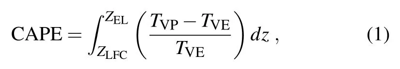
where TVPand TVEare the air parcel and environment virtual temperature,respectively.ZLFCand ZELare the levels of free convection and balance,respectively.CAPE is the buoyancywork performed on an airparcelduring theprocess of air rising from free height to the heightof buoyancy balance,representing the intensity of unstable energy stored in the atmosphere.Furthermore,the strong convective instability needs to release unstable energy,which requires storage of sufficientunstableenergy before thestrong convection occurs.Convective inhibition energy(CIN)isameasureof convective inhibition quantities,representing the air parcelwork performed on theenvironmentduring the risingof theairparcel from theground(Z0)to theheightof freeconvection(Z1):

Usually,the CIN cannotbe so small that theunstableenergy releases piecemeal,but italso cannotbe so large that it cannotproduce deep convection.As shown in Fig.4,before the precipitation(0000 UTC 21 July),high valuesof CAPE extended gradually from thesouthwestto Beijing;itsmaximum was located in the southwestern region of Beijing,reaching to approximately 1200 Jkg−1.Because a low-level jet controlled the Beijing region,conveying thewarm moistairflow w ith huge unstable energy to the storm continuously,itwas an important reason for themaintenanceand developmentof the convective instability.At the same time,the CIN was high,about−80 J kg−1,and itwas not easy to trigger the convection.Thus,during thisperiod of time,unstableenergy accumulated for heavy rainfall.At 0600 UTC 21 July high values of CAPE covered the Beijing area,reaching amaximum of 1400 J kg−1.At thismoment there was obvious moisture convergence in the lower level.The surrounding moist air continued to target the storm area,enhancing the atmospheric unstable energy(figure omitted).Meanwhile, the CIN weakened significantly,reducing to−20 Jkg−1,so the convectiveunstableenergy could be easily released w ithoutstrong,dynam ic lifting conditions.With thedevelopment of convection,thew ind direction turned southerly;thus,the transportation ofunstableenergy brokeoffand the CAPE deceased rapidly.
3.2. Symmetric instability
The analysismentioned above shows that before 0600 UTC 21 July there was convective instability in the lower level,which gradually weakened with time.In this subsection,we show how the atmosphere changed into symmetric instability after the occurrence of rainfall.
As iswell-known,symmetric instability generally refers to the instability of theairparcelduring theslantw iseupward performance.TheMPV can be represented as:

whereζais the absolute vorticity.θseis pseudo-equivalent potential temperature.MPV canbedivided into two portions:


Fig.4.(a)CAPEon the surfaceandw ind vector(units:m s−1)at850 hPaand(b)CIN on thesurfaceandw ind vector(units:m s−1)at850 hPa,at0000UTC 21 July.

where MPV1is the coupling of the vertical component of absolute vorticity and the vertical gradient of the pseudoequivalentpotential temperature(θse),which isthebarotropic component.It represents the cooperation of inertial instability and convective instability.Because the absolute vorticity of large-scalemotion is positive in the Northern Hemisphere,thenegativeorpositiveofMPV1isonly dependenton∂θse/∂p.When the atmosphere is in convective instability,∂θse/∂p>0 and MPV1<0.MPV2is thebaroclinic componentofMPV,representing the coupling effectofmoistbaroclinity and the vertical shear of the horizontalw ind.When MPV1>0 and MPV<0,the atmosphere is in symmetric instability.
Figure5 shows the changeover timeofMPV,MPV1and MPV2.From 0000 UTC 20 to 0600 UTC 21 July therewas negative MPV1at a height of 900–800 hPa(Fig.5a),signifying a convective unstable atmosphere,which was consistentw ith the aforementioned results.Meanwhile,MPV was also negative(Fig.5c),signifying a symmetric unstable atmosphere.However,Bennetts and Sharp(1982)noted that when convective instability and symmetric instability coexist, theatmosphere ismainly dom inated by convective instability because thegrow th rateof convective instability is larger than symmetric instability.During the period 0600–1800 UTC 21 July,due to the precipitation,the convective unstable energy was released and the atmosphere changed into neutral stratification.At thismoment,MPV10.Meanwhile,the baroclinicity and the horizontalgradientof potential temperature strengthened at 900–800 hPa due to the enhanced low-level jetand theincursionofacold frontoverBeijing.Thus,MPV2wasenhanced and became negative,causing MPV<0.The condition ofMPV1>0 and MPV<0 wasmet,so the atmosphere displayed symmetric instability during this period.In addition,it isworth noting that the strongestnegativeMPV2correspondedw ith themaximum precipitation.
Furthermore,based on the definition that the atmosphere is a symmetric unstable atmosphere when the slope of the isentropicsurfacesisgreater than theslopeof themomentum, the steeper the isentropic surfaceswere,the easier itwas for symmetric instability to occur.Before theheavy rainfall(Fig. 3a)the isentropic surfacewasgentle,almosthorizontally distributed.Then,at1200UTC 21 July(Fig.3b)the frontmoved into the Beijing area,corresponding to the strongest frontal rainfall.The latent heat released redistributed themoisture and temperature,resulting in steeply inclined isentropic surfaces.This allowed the atmosphere to form the symmetric instability.Figure 6 shows the slope difference between the isentropic surface and themomentum surface over the Beijing area.There was an obvious positive region during the precipitation at 700 hPa,indicating the occurrence of the symmetric instability.

Fig.5.Temporal evolution of(a)MPV1,(b)MPV2,(c)MPV (units:10−5K m2s−1kg−1)over Beijing(39.8°–40.0°N, 115.8°–116.2°E),where the black contour denotes the observation of 6-h accumulated rainfall(units:mm).

Fig.6.Temporalevolution of the slope difference between the isentropic surface and themomentum surface over the Beijing area,where the black contour denotes the observation of 6-h accumulated rainfall(units:mm).
Analysis of the convective instability and symmetric instability indicates thatapproximately 12–24 hoursbefore the storm,the atmosphere wasmainly in convective instability in the lower level.The convective instability experienced a weak–strong–weak process,but the heavy precipitation did not occur at themoment of strongest convective instability. W ith the occurrence of heavy rain,the convective instability energywas released and the convective instabilityweakened. At thesame time,thesymmetric instabilitywasstrengthenedby theenhancementofatmospheric baroclinicity.The results are consistentw ith the conclusion of Liu etal.(2014),who usedWRF(Weather Research and Forecasting Model)simulation data to analyze the instability during precipitation.
4. Convective instability evolution before the rainfall
To explore the factors affecting the evolution of convective instability before the rainstorm and provide a theoretical basis for forecasting convective precipitation,the convective instability tendency equationwasdeduced.
The thermodynam ic equation in pressure coordinates is as follows:
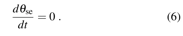
Take the partialderivative of both sidesof Eq.(6),

and substitute the mass continuity equation(∂u/∂x)+ (∂v/∂y)+(∂ω/∂p)=0 into Eq.(7),

where M=−(∂u/∂p)(∂θse/∂x)−(∂v/∂p)(∂θse/∂y)+ [(∂u/∂x)+(∂v/∂y)](∂θse/∂p)is the potential divergence equation(Ran et al.,2013).Mrepresents the curl of horizontalw ind rotated 90°and projected on the direction of the pseudo-equivalent potential temperature,indicating the coupling of horizontal divergence and the vertical shear of the horizontal w ind.[(∂u/∂p)(∂θse/∂x)+(∂v/∂p)(∂θse/∂y)] is the baroclinic component of M,and it also represents the vertical component of the convective vorticity vector.It reflects the coupling of vertical w ind shear and atmospheric baroclinicity.[(∂u/∂x)+(∂v/∂y)](∂θse/∂p)is the barotropic component of M,representing the coupling of horizontal divergence and convective instability.−vvv·∇(∂θse/∂p)is the advection of convective instability.Thus, the local variation of convective instability ismainly influenced by advection and potentialdivergence.
Figure7 is the verticaldistribution of the forcing terms in Eq.(8)affecting the convective instability at1200 UTC 20 July.As shown in Fig.7a,therewere two unstable areas in the troposphere.Onewas located at110°–114°E at700 hPa. At this location the advection(Fig.7c)was positive but the potential divergence(Fig.7b)was primarily negative,so the convective instability herewasmainly caused by the advection term.The other unstable areawasat116°–118°E at900 hPa,which had amajor effect on the heavy rainfall in Beijing.Analysisof the verticaldistribution,the potentialdivergence(Fig.7b)and theadvection(Fig.7c)indicatesboth had a positive area thatoverlapped with the convective unstable area.Thus,potential divergence and advection both played an important role in the developmentof convective instability.The potential divergence can be divided into barotropic and baroclinic components,as shown in Figs.7d and e.The baroclinic termin the unstable region was negative and the barotropic term waspositive,meaning that the convective instability wasmainly dom inated by the barotropic term,and thebaroclinic term played an offsetting role.
The temporal evolution of the forcing terms(Fig.8) shows the convective instability from 0000 UTC 20 to 0600 UTC 21 July.Then,the convective instability weakened and the atmosphere changed into neutral stratification.Figure 8b indicates that the potential divergence wasmainly positive at900–800 hPabefore the rainstorm,helping to develop and maintain the convective instability.Theadvection also played an important role in convective instability development,butit was relatively weakerbefore the rainstorm and stronger during the approaching rainfall process.Thus,the potential divergence contributedmore to the convective instability.Figures 8d and e show that the barotropic componentof potential divergencewas primarily positive before the heavy rainfall,so it actively promoted the development of convective instability.Thebaroclinic componentof potentialdivergence was weak and negative before the precipitation,having an offsetting influence.However,itgradually became stronger during precipitation,having a great impacton inhibiting the convective instability.The barotropic component of potential divergence played themost significant role in affecting the convective instability before the rainstorm.During the period of precipitation from 0000 UTC 21 to 0000 UTC 22 July the convective instability weakened,primarily due to the baroclinic component of the potential divergence mentioned above.The reasonmighthavebeen that the low-level jet strengthened during the precipitation,bringing about the vertical shear of horizontalw ind and the atmosphere’s baroclinic enhancement.Meanwhile,themoist,warm airclimbed along the cold air in front and the cold and warm airs converged,causing theslantw ise isentropic surfaceand thehorizontalgradientof pseudo-equivalentpotential temperature to increase.Thus,thebaroclinic componentwasenhanced,partially offsetby the effectsof the barotropic component,ultimately causing the convective instability to decrease.On the other hand,itwas also an important reason for the enhancement of the symmetric instability,which can be seen in the nextpart.
Itcan be concluded that thebarotropic componentof potential divergence played the leading role in promoting the development of convective instability before the rainstorm. After the storm had occurred the baroclinic term of the potential divergence suppressed the convective instability development.
5. Symm etric instability during the rainfall
According to theaboveanalysissymmetric instability occurred over Beijing from 0200UTC 21 to 1800UTC 21 July. It reached a peak at1200 UTC 21 July,which corresponded
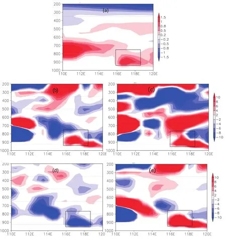
Fig.7.Vertical distribution of the forcing terms in Eq.(8)affecting the convective instability along 40°N at 1200 UTC 20 July:(a)∂θse/∂p;(b)M;(c)vvv∇·(∂θse)/∂p;(d)−(∂u/∂p)(∂θse/∂x)−(∂v/∂p)(∂θse/∂y);(e)(∂u/∂x+∂v/∂y)(∂θse/∂p)(units:10−8K s−1m−1).
w ith themaximum precipitation.Furtheranalysis ismade to explore the factors affecting the evolution of symmetric instability during precipitation.
Under adiabatic and frictionless conditions the potential vorticity is conservative(Wu etal.,1995):

Equation(9)can be rew ritten as:

Then,

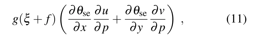
where d MPV1/dt and d MPV2/dt are the individual variations of MPV1and MPV2,respectively.Under the prem ise of MPV conservation,there is a certain mutual conversion between MPV1and MPV2.According to Eq.(10),when d MPV1/dt increases d MPV2/dt w ill decrease,and when d MPV1/dt decreases d MPV2/dt w ill increase.The conditions of MPV1>0 and MPV<0 signify symmetric instability in the atmosphere.Thus,when d MPV1/dt>0 MPV1increasesand when d MPV2/dt<0MPV2decreases, and the symmetric instability would be maintained and would develop.In Eq.(11),g(∂θse/∂p)[(∂ω/∂y)(∂u/∂p)−(∂ω/∂x)(∂v/∂p)]is thecoupling of thevorticity tilting termand verticalgradientof pseudo-equivalentpotential temperature,and g(ξ+f)[(∂θse/∂x)(∂u/∂p)+(∂θse/∂y)(∂v/∂p)] is the coupling of verticalvorticity and thebaroclinic componentofpotentialdivergence.Thus,the individualvariation of MPV2ismainly affected by the two termsabove.
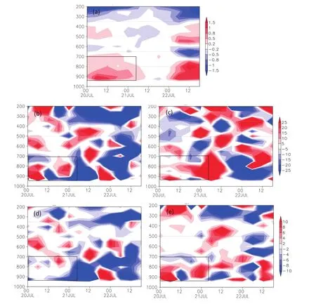
Fig.8.Temporal evolution of the forcing terms in Eq.(8)affecting the convective instability over Beijing area(39.8°–40.0°N,115.8°–116.2°E):(a)∂θse/∂p;(b)M;(c)vvv∇·(∂θse)/∂p;(d)−(∂u/∂p)(∂θse/∂x)−(∂v/∂p)(∂θse/∂y);(e) (∂u/∂x+∂v/∂y)(∂θse/∂p)(units:10−8K s−1m−1).
Figure 9 shows the vertical distribution of the two forcing terms of MPV2at themomentof strongest precipitation (1200 UTC 21 July).Themaximum 6-h accumulated precipitation in Beijing reached 80mm and the gradientof each forcing term wasstrong in the precipitation region.The coupled term of vertical vorticity and potential divergence was relatively strong(Fig.9b)compared w ith the other terms. Therewasanegativeareaat800 hPaover Beijing,indicating d MPV2/dt decreased,thus causing MPV2to become negative and enhancing the symmetric instability.At the same time,therewasaweakernegativearea to thesouth of thepositivearea.Therewasaw ide positive zoneof the fi rst term on the right-hand side of Eq.(11)over Beijing(Fig.9a),which wasweaker than the second term,inhibiting the development of symmetric instability.

Fig.9.Vertical distribution of the forcing terms in Eq.(11)affecting the individualvariationofMPV2 along 40°N,where the black contour denotes the observation of 6-h accumulated rainfall(units:mm):(a)g(∂θse/∂p)[(∂ω/∂y)(∂u/∂p)−(∂ω/∂x) (∂v/∂p)];(b)−g(ξ+f)[(∂θse/∂x)(∂u/∂p)+(∂θse/∂y)(∂v/∂p)](units:10−10 Km2 s−2 kg−1).

Fig.10.Temporal evolution of the forcing terms in Eq.(11) affecting the individual variation of MPV2 along 40°N over the Beijing area(39.8°–40.0°N,115.8°–116.2°E),where the black contour denotes the observation of 6-h accumulated rainfall(units:mm):(a)g(∂θse/∂p)[(∂ω/∂y)(∂u/∂p)−(∂ω/∂x) (∂v/∂p)];(b)−g(ξ+f)[(∂θse/∂x)(∂u/∂p)+(∂θse/∂y)(∂v/∂p)](units:10−10 Km2 s−2 kg−1).
Further analysis on the temporal evolution of the three forcing terms isshown in Fig.10.Because therewasno precipitation during the period 0000 UTC 20 to 0000 UTC 21 July,the forcing termswereallweak.From 0200UTC 21 the heavy rain occurred in the Beijing area,and so the symmetric instability strengthened.During the precipitation,the contribution of the coupled term of vertical vorticity and potential divergence was significant(Fig.10b).There was a strong negative area at the lower level of 900–800 hPa from 0000 UTC to 1800UTC 21 July,corresponding to the heavy rain. The negative area caused MPV2to decreasew ith time,contributing to the enhancement of symmetric instability.This term was strongest at 1200 UTC 21,corresponding to the maximum precipitation and strongest symmetric instability. The fi rstcoupled term of vorticity tilting and theverticalgradient of pseudo-equivalent potential temperature(Fig.10a) were weak and positive,having an impact on inhibiting the developmentof the symmetric instability.
As seen from the analysis above,the coupling of verticalvorticity and the baroclinic componentof potentialdivergencemade themost remarkable contribution tomaintaining and developing the symmetric instability during the precipitation.The reason for the anomaly of this term was the tilting of the isentropic surface due to the release of latentheat, causing rapid developmentof vertical vorticity.Meanwhile, the enhancement of the low-level jet increased the vertical w ind shear.Moreover,a cold frontmoved into the Beijing area and the cold and warm airmasses converged,enhancing the three-dimensional spatial gradients of the pseudoequivalent temperature.These factors synthetically caused−g(ξ+f)[(∂θse/∂x)(∂u/∂p)+(∂θse/∂y)(∂v/∂p)]to decrease,thus contributing to the development of symmetric instability.
Comparing the effect of factors on convective instability and symmetric instability showed some correlation.The baroclinic componentofpotentialdivergence is thekey point, which weakened the convective instability and enhanced the symmetric instability during the precipitation.
6. Conclusion
In this paper,using a heavy rain event that occurred in Beijing on 21 July 2012 asan example,GFS reanalysis data from NCAR–NCEPwere used to analyze the characteristics and evolutionmechanism of convectiveand symmetric instability beforeand during theNorth China rainstorm.Themain conclusions can be summarized as follows:
(1)Approximately 12 hours before the rainstorm the atmospherewasmainly dom inated by convective instability in the lower level of 900–800 hPa.The strong southwesterly low-level jet conveyed themoistand warm airflow continuously to the torrential rain area,maintaining and enhancing the unstable energy.When the precipitation happened and the unstable energy was released,the convective instability weakened.Meanwhile,due to baroclinic enhancement in the atmosphere,the symmetric instability strengthened,maintaining and promoting the developmentof the torrential rain.
(2)By deriving the convective instability tendency equation,the evolution characteristicsand impact factorson convective instability were analyzed.Before the rainstorm the barotropic componentof potentialdivergence and the advectionof convectiveinstability played amajor role inpromoting thedevelopmentof convective instability.After theprecipitation occurred the convective instabilityweakened duemainly to the baroclinic componentof the potentialdivergence.
(3)The primary factorsaffecting the developmentof the symmetric instability during the precipitationwere the cooperation between vertical vorticity and the baroclinic componentof potential divergence,as established by analyzing theMPV tendency equation.Importantly,the baroclinic componentof potentialdivergencewas the key point,which weakened the convective instability and enhanced the symmetric instability during the precipitation.When the convective instability decreased and the symmetric instability increased, the rainfall eventoccurred.Thus,the baroclinic component of potential divergencemay be an important signal for forecasting,which needs further investigation and discussion.
Acknow ledgements.This study was supported by the National Natural Science Foundation of China(GrantNos.41175060 and 41375052),the Key Program of the Chinese Academy of Sciences(GrantNo.KZZD-EW-05),the NationalBasic Research Program of China(GrantNo.2013CB430105),and the State Key Laboratory of SevereWeather(LASW),Chinese Academy ofMeteorological Sciences(GrantNo.2013LASW-A06).
REFERENCES
Bennetts,D.A.,and B.J.Hoskins,1979:Conditional symmetric instability-apossibleexplanation for frontalrainbands.Quart. J.Roy.Meteor.Soc.,105,945–962.
Bennetts,D.A.,and J.C.Sharp,1982:The relevance of conditional symmetric instability to the prediction ofmesoscale frontal rainbands.Quart.J.Roy.Meteor.Soc.,108,595–602.
Charney,J.G.,1947:The dynam icsof long waves in a baroclinic westerly current.J.Meteor.,4,135–162.
Eady,E.T.,1949:Longwaves and cyclonewaves.Tellus,1,33–52.
Gao,S.T.,2000:The instability of thevortex sheetalong theshear line.Adv.Atmos.Sci.,17,525–537,doi:10.1007/s00376-000-0016-7.
Gao,S.T.,and Y.S.Zhou,2001:The instability of thevortex sheet along the horizontal shear line.Acta Meteorologica Sinica, 59,393–404.(in Chinese)
Hoskins,B.J.,1974:The role of potential vorticity in symmetric stability and instability.Quart.J.Roy.Meteor.Soc.,100, 480–482.
Liu,L.,L.K.Ran,Y.S.Zhou,and S.T.Gao,2014:Analysison the instability and triggermechanism of torrentialrainfalleventin Beijing on 21 July 2012.Chinese J.Atmos.Sci.,39,583–595, doi:10.3878/j.issn.1006-9895.1407.14144.(in Chinese)
Lu,W.S.,and H.Y.Shao,2003:Generalized nonlinear subcriticalsymmetric instability.Adv.Atmos.Sci.,20,623–630,doi: 10.1007/BF02915505.
Ran,L.K.,L.Liu,N.Li,and Y.B.Qi,2013:The analysis of the potential-divergencewave activity density and itsapplication to typhoon precipitation.Chinese Journal ofGeophysics,56, 3285–3301.(in Chinese)
Ran,L.K.,Y.B.Qi,and S.C.Hao,2014:Analysis and forecasting of heavy rainfall case on 21 July 2012 w ith dynamical parameters.Chinese J.Atmos.Sci.,38,83–100.(in Chinese)
Schultz,D.M.,and P.N.Schumacher,1999:The use and m isuseof conditionalsymmetric instability.Mon.Wea.Rev.,127, 2709–2732.
Schultz,D.M.,and J.A.Knox,2007:Banded convection caused by frontogenesis in a conditionally,symmetrically,and inertially unstableenvironment.Mon.Wea.Rev.,135,2095–2110.
Seltzer,M.A.,R.E.Passarelli,and K.A.Emanuel,1985:The possible roleof symmetric instability in the formation of precipitation bands.J.Atmos.Sci.,42,2207–2219.
Seman,C.J.,1994:A numericalstudy ofnonlinearnonhydrostatic conditional symmetric instability in a convectively unstable atmosphere.J.Atmos.Sci.,51,1352–1371.
Stone,P.H.,1966:On non-geostrophic baroclinic stability.J.Atmos.Sci.,23,390–400.
Stone,P.H.,1970:On non-geostrophic baroclinic stability:Part II.J.Atmos.Sci.,27,721–726.
Stone,P.H.,1971:Baroclinic stability undernon-hydrostatic conditions.J.Fluid Mech.,45,659–671.
Sun,J.S.,N.He,R.Guo,and M.X.Chen,2013a:The configuration change and train effectmechanism ofmulti-cell storms. Chinese J.Atmos.Sci.,37,137–148.(in Chinese)
Sun,J.H.,S.X.Zhao,S.M.Fu,H.J.Wang,and L.L.Zheng, 2013b:Multi-scale characteristics of record heavy rainfall over Beijing area on July 21,2012.Chinese J.Atmos.Sci., 37,705–718.(in Chinese)
Wang,J.Y.,C.G.Cui,X.F.Wang,and W.J.Cui,2014:Analysison water vapor transportand budgetof the severe torrential rain over Beijing Region on 21 July 2012.Meteorological Monthly,40,133–145.(in Chinese)
Wu,G.X.,Y.P.Cai,and X.J.Tang,1995:Moistpotentialvorticity and slantw ise vorticity development.Acta Meteorologica Sinica,53,387–405.(in Chinese)
Wu,G.X.,and Y.P.Cai,1997:Vertical w ind shear and downsliding slantw ise vorticity development.Scientia Atmospherica Sinica,21,273–282.(in Chinese).
Wu,G.X.,and H.Z.Liu,1999:Complete form of vertical vorticity tendency equation and slantw ise vorticity development. Acta Meteorologica.,57,1–15.(in Chinese)
Xu,Q.,1986:Conditional symmetric instability and mesoscale rainbands.Quart.J.Roy.Meteor.Soc.,112,315–334.
Zhang,K.S.,1988a:Onmesoscale instability of a baroclinic flow 1.Symmetric instability.ActaMeteorologica Sinica,46,258–266.(in Chinese)
Zhang,K.S.,1988b:Onmesoscale instability of abaroclinic flow 2.transversalinstability.ActaMeteorologica Sinica,46,385–392.(in Chinese)
Zhang,L.F.,and M.Zhang,1992:Wave-CISK and symmetric instability.Scientia Atmospherica Sinica,16,669–676.(in Chinese)
23March 2015;revised 31May 2015;accepted 16 June 2015)
:Liu,L.,L.K.Ran,and S.T.Gao,2016:Evolution of instability before and during a torrential rainstorm in North China.Adv.Atmos.Sci.,33(1),110–120,
10.1007/s00376-015-5080-0.
∗Corresponding author:Lingkun RAN
Email:rlk@mail.iap.ac.cn
杂志排行

Advances in Atmospheric Sciences的其它文章
- Variation in Summer Surface Air Tem perature over Northeast Asia and Its Associated Circulation Anomalies
- Ensemble Transform Sensitivity Method for AdaptiveObservations
- Dynam ic and Thermodynam ic Featuresof Low and Midd le Clouds Derived from Atmospheric Radiation Measurement Program Mobile Facility Radiosonde Data at Shouxian,China
- Observational FactsRegarding the Joint Activitiesof the Southwest Vortex and Plateau Vortex after ItsDeparture from the Tibetan Plateau
- Teleconnected Influenceof the BorealW inter Antarctic Oscillation on the Somali Jet:Bridging Role of Sea Surface Tem perature in Southern High and Midd le Latitudes
- Effectsof Surface Flux Parameterization on the Numerically Simulated Intensity and Structureof Typhoon Morakot(2009)