Study on Soil Infiltration Capability and Its Impact Factors of Different Land-use Types in Purple Soil Region
2016-01-11,,,,,,,,,
, , , , , , , , ,
1.Guangxi Communication Planning Surveying and Designing Institute, Nanning 530000, China; 2. Key Laboratory of Eco-environments in Three Gorges Region (Ministry of Education), Southwest University, Chongqing 400716, China; 3. Institute of Soil and Water Conservation, Chinese Academy of Sciences and Ministry of Water Resources, Yangling 712100, China
StudyonSoilInfiltrationCapabilityandItsImpactFactorsofDifferentLand-useTypesinPurpleSoilRegion
BinMO1*,XiaoyanCHEN2,3,TaoLIU1,YicuiYANG1,ZhixingLIN1,XiufengHUANG1,QiliangHUANG1,HuiJIAN1,TujinZHOU1,YunkangSHEN1
1.Guangxi Communication Planning Surveying and Designing Institute, Nanning 530000, China; 2. Key Laboratory of Eco-environments in Three Gorges Region (Ministry of Education), Southwest University, Chongqing 400716, China; 3. Institute of Soil and Water Conservation, Chinese Academy of Sciences and Ministry of Water Resources, Yangling 712100, China
Soil infiltration capability is the hot spot topic of soil erosion studies and soil physical and chemical properties have great influence on it. A new infiltration method point-source infiltration method was used to precisely evaluate the infiltration capability in different purple soil land-use types. And correlation analysis on soil physical and chemical properties and soil infiltration capability of different land-use types was performed. Results showed that: (i) there is a large difference among soil physical and chemical properties in different land-use types, soil water content, non-capillary porosity, capillary porosity, content of > 0.25 mm aggregates and organic matter content in the top soil are greater than those in the subsoil; (ii) soil infiltration capability showed differences among different land-use types. Land use showed great effects, in general, the order of decrease on initial infiltration rate and average infiltration rate was: woodland slope> slope farmland> grassland, the order of decrease on steady infiltration rate was: slope farmland>woodland> grassland and the time reaching stable state was: slope farmland> woodland>grassland;(iii) correlation analysis showed that there was a significantly positive correlation between initial infiltration rate and wet sieve MWD value and structural damage rate, and it had a significantly negative correlation with capillary porosity; (iv) steady infiltration rate and non-capillary porosity showed the significantly positive correlation, and it had a significantly negative correlation with the soil bulk density; (v) the average infiltration rate and non-capillary porosity and structural damage rate showed a positive correlation and the correlation coefficient was large and there was a negative correlation between average infiltration rate and soil bulk density and capillary porosity, and the absolute value of correlation coefficient was relatively large. The results of this study can provide the theoretical basis for soil infiltration study in purple soil area.
Forestry, Soil infiltration capability, Point source infiltration, Different land-use types, Soil physical and chemical properties, Correlation
1 Introduction
Soil erosion can destroy arable land, which restricts the development of agricultural economy, and it is one of the global disasters threatening ecological environment[1-2]. The soil infiltration is an important parameter to analyze and characterize the soil erosion process[3-4], and also an important part of soil water cycle. The purple soil area is one of the areas with the most serious soil erosion in China, so it is important to study the soil infiltration capability of different land-use types in this area. There are many methods to measure the soil infiltration capability, such as double-ring method[5-7], cutting ring method[8-10], single-ring infiltration method[11-12]and disc permeameter method[13-15]. The point source infiltration has the advantages of saving time and water and high accuracy[16], but there is no report on the study of point source infiltration in the soil infiltration of the purple soil area. In this experiment, we measure the soil infiltration capability of different land-use types to accurately obtain the regular pattern of soil infiltration of different land-use types in this area. Many factors affect soil infiltration, and soil physical and chemical property is one of the main influencing factors. Many researchers[17-19]find that soil infiltration capability is closely related to soil bulk density, soil aggregates, organic matter, porosity and other physical and chemical properties. There are great differences in the soil physical and chemical properties between different land-use types, leading to significant differences in soil infiltration capability. In order to explore the correlation between the soil physical and chemical properties of different land-use types and their infiltration capability, we carry out the regression analysis to obtain the weight relationship between various indicators of soil physical and chemical properties and soil infiltration capability. This study can provide a reference for the research of sustainable agricultural development, and the correlation between soil infiltration and soil physical and chemical properties in the purple soil area.
2 Materials and methods
2.1OverviewoftheexperimentalareaThe experimental site is the experimental base in the mountain behind Southwest University, with geographic coordinates of 106°24′ E and 29°48′ N, and altitude of 268 m. This region has a subtropical monsoon climate, and the average annual temperature is about 18℃. The annual average rainfall is about 1089.8 mm, and the rainfall is uneven and concentrated in May to September, accounting for 70% of year-round rainfall. In the experimental site, three similar plots with gradient of about 5° are selected respectively, and the height difference is within 20 m. The plots from higher slope to lower slope are woodland, slope farmland and grassland.
2.2ExperimentalequipmentsThe test equipments include point source infiltration device (consisting of water pump, computer, camera, buckets,etc.), shovel, aluminum case, circular knife, soil cutting knife, thermometer, stopwatch, and funnel).
2.3DeterminationmethodsPoint source infiltration is a new method in the purple soil area, and its measuring principles and procedures[16]are as follows: (i) Water pump is water sender with constant flow, and its speed range is 0-100r/min. The available water flow range is 0-3.45mL/min, and the pump speed is adjusted to control the size of constant water flow. The water flow rate is designed as 2 L/h in the study. (ii) Digital camera is used to record the change in the wetted area of water flow on the soil surface over time, and estimate the initial high infiltration performance of topsoil. (iii) Computer hardware and software include notebook and digital image computing software. During the experiment, the digital images taken by the camera are imported to computer, and the wetted area of water flow on the ground by digital image processing software, and then the soil infiltration rate is calculated. When a certain amount of water is supplied to the surface, the initial infiltration rate is high and the corresponding wetted surface area is small. With the advance of infiltration process, the soil infiltration capability continues to decline. When the soil water content in a certain area of wet topsoil basically reaches a saturation state, the soil infiltration process is to be controlled by the infiltration capacity of plow pan, and when the wetted area reaches a certain value, the infiltration rate remains basically unchanged. The numerical method is used to seek the approximate solution. A small time interval is selected and the average infiltration value in each period is taken, thus the approximate estimated value ofi(t) is calculated by recursion. Assuming the different measurement periods are Δt1, Δt2,…,Δtn, respectively; the increment of wetted area of the ground surface is ΔA1, ΔA2,…, ΔAn, respectively; the corresponding horizontal projected area is ΔA1cosα, ΔA2cosα,…, ΔAncosα, respectively. The value in various periods is calculated as follows:
The water balance int1isq=i1ΔA1cosα
(1)
The water balance int2isq′=i2ΔA1cosα+i1ΔA2cosα
(2)
The water balance intnisq′=inΔA1cosα+in-1ΔA2cosα+i1ΔAncosα
(3)
After calculating the infiltration rate int1by equation (1), we can get the infiltration rate in different periods as follows:
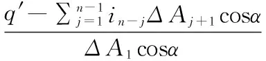
(4)
wherein-jis the soil infiltration rate (mm/h) in timen-j, and also represents the average infiltration rate in timen-j;ΔAj+1is the increment of wetted area (mm2) on the surface in timej+1;inis the soil infiltration rate (mm/h) in timetn, and also represents the average infiltration rate in timen;ΔAnis the increment of wetted area (mm2) on the surface in timetn-tn-1.
After selecting the plot and cleaning the ground, the water flow and photo collection interval are adjusted (3 min per photo in this experiment), and the instrument is installed. After calibration is complete, the pump switch and computer start button were pressed at the same time. After the end of the experiment, the pump and camera were turned off and the experimental data of infiltration process were calculated on computer. The experiment was repeated three times for each land use type, and it should be done in the same period. Before infiltration experiment, the undisturbed soil was hierarchically collected from the plot by cutting ring, and then brought back to laboratory to determine the soil porosity, bulk density and other physical properties. The mixed soil samples were collected using "grid method". For each land use type, 9 small soil samples were collected, and every three small soil samples were mixed into a soil sample, a total of 3 soil samples. They were brought back to the laboratory to be air-dried. Half of them were sifted through a 1 mm sieve to determine the mechanical composition, micro-aggregates and organic matter; the other half of samples were not sifted, and they were used for the determination of large aggregates and their water stability. The experiment was completed from early March to late April 2014.
3 Results and discussions
3.1Soilphysicalandchemicalpropertiesofdifferentland-usetypesSoil infiltration capability is affected by many factors, and soil physical and chemical property is an indicator to characterize soil, so it is one of the main factors affecting soil. Therefore, the analysis of difference in the soil physical and chemical properties between different land use types in the purple soil area is a prerequisite for further study of soil infiltration capability, and also an internal mechanism to reveal the difference in soil infiltration capability. The soil physical and chemical properties of different land-use types in the study area are shown in Table 1.From the Table 1, there are great differences in the soil physical and chemical properties between different land use types. For the 0-20 cm soil, grassland has the highest soil bulk density, followed by woodland, and slope farmland has the lowest soil bulk density; And the 20-40 cm soil, grassland has the highest soil bulk density, followed by slope farmland, and woodland has the lowest soil bulk density. The early farming on the topsoil of slope farmland can easily cause loose soil, and the high soil bulk density of soil under plow layer is caused by trample pressure on the surface of slope farmland. In terms of initial soil water content, the 0-20 cm soil has higher content than the 20-40 cm soil, because the experimental location has a subtropical monsoon climate, with high annual surface humidity, so the initial soil water content is lower in the subsoil. The initial soil water content of 0-20 cm and 20-40 cm soil of slope farmland is 15.13%, 5.74% and 12.08%, 6.11% higher than that of woodland and grassland, respectively. The reason is that the slope farmland is watered by people, and grassland has high shade density and good water retention capability, with high moisture content. It is similar to the findings of Liu Chunlietal.[20]. That the non-capillary porosity, it is highest for slope farmland, followed by woodland and grassland. The non-capillary porosity of 0-20 cm and 20-40 cm soil of slope farmland is 22.19%, 146% and 32.46%, 293% higher than that of woodland and grassland, respectively, because artificial cultivation has the greatest impact on slope farmland, and the woodland has more developed roots than grass. In terms of capillary porosity, it is highest for grassland, followed by woodland and slope farmland. Besides, >0.25 mm aggregates content, it is highest for slope farmland, followed by grassland and woodland. The content of 0-20 cm and 20-40 cm soil of slope farmland is 9.15%, 17.37% and 10.71%, 5.99% higher than that of woodland and grassland, respectively, because slope farmland is affected by human fertilization, and grassland is affected by many small roots and soil fauna activity. For the organic matter content, it is highest for slope farmland, followed by grassland and woodland. The content of 0-20 cm and 20-40 cm soil of slope farmland is 131%, 83.17% and 72.08%, 56.17% higher than that of woodland and grassland, respectively, and the reason is basically similar to that for >0.25 mm aggregates content. In terms of wet sieve MWD value, it is highest for woodland, followed by grassland and slope farmland. Then the structural damage rate, it is highest for woodland, followed by slope farmland and grassland. The structural damage rate of 0-20 cm and 20-40 cm soil of woodland is 47.30%, 40.68% and 30.76%, 31.24% higher than that of grassland and slope farmland, respectively, which is related to the organic matter and aggregates content of soil[21].
Table1Soilphysicalandchemicalpropertiesofdifferentland-usetypes
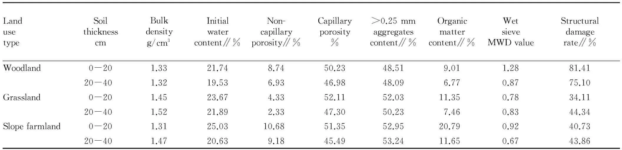
LandusetypeSoilthicknesscmBulkdensityg/cm3Initialwatercontent∥%Non-capillaryporosity∥%Capillaryporosity%>0.25mmaggregatescontent∥%Organicmattercontent∥%WetsieveMWDvalueStructuraldamagerate∥%Woodland0-201.3321.748.7450.2348.519.011.2881.4120-401.3219.536.9346.9848.096.770.8775.10Grassland0-201.4523.674.3352.1152.0311.350.7834.1120-401.5221.892.3347.3050.237.460.8344.34Slopefarmland0-201.3125.0310.6851.3552.9520.790.9240.7320-401.4720.639.1845.4953.2411.650.6743.86
3.2Soilinfiltrationcapabilityofdifferentland-usetypesInitial infiltration rate, stable infiltration rate and average infiltration rate are three most commonly used indicators to evaluate soil infiltration[22-23]. There are great differences in the soil infiltration capability between different land-use types, and to better express such differences, we take the average of three groups of duplicate test results for a comparative analysis to draw the corresponding conclusions. The soil infiltration capability of different land-use types is shown in Table 2. The initial infiltration rate is signified by the infiltration rate at the first 1 min; the steady infiltration rate is the infiltration rate when soil infiltration reaches a steady state; the average infiltration rate is the ratio of total amount of soil water infiltration to time within a certain period. Table 2 shows that there are great differences in the soil infiltration capability between different land-use types. In terms of initial infiltration rate, it is highest for woodland, followed by slope farmland and grassland. The maximum difference reaches 77.72% (woodland and grassland) while the minimum difference is 28.19% (grassland and slope farmland). This is somewhat different from the findings of Liu Zhiqinetal.[10, 24], which may be due to large differences in soil texture in different regions. Compared with the initial infiltration rate, the 20th min infiltration rate of woodland declines most (average decline of 26.56 times), followed by grassland (average decline of 21.98 times), and slope farmland (average decline of 15.93 times). The reason is that the soil structure of slope farmland is good, and its soil physical and chemical properties are better than those of woodland and grassland except bulk density; the initial soil water content of woodland is lowest and its soil aggregates structure is most unstable. The steady infiltration rate of slope farmland is highest, followed by slope farmland and grassland. The maximum difference is 42.85% (slope farmland and grassland), and the minimum difference is 12.36% (slope farmland and woodland). The early farming on slope farmland creates a good soil structure, the root activity of woodland is better than that of grassland, and steady infiltration rate is closely related to soil plow layer structure, so the steady infiltration rate of soil is high for slope farmland. The average infiltration rate is highest for woodland, followed by slope farmland and grassland. The maximum difference is 53.66% (woodland and grassland), and the minimum difference is 8.62% (woodland and slope farmland). The reason is that the early infiltration rate of woodland is high, and it is the average during the entire infiltration process. In terms of the time to reach steady infiltration, it is longest for slope farmland, followed by woodland and grassland. However, there is no large difference, and the maximum difference is not more than 10%.
Table2Soilinfiltrationcapabilityofdifferentland-usetypes
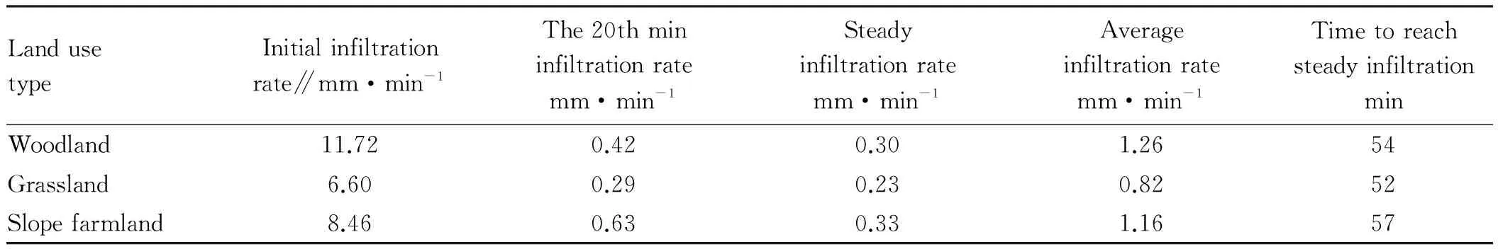
LandusetypeInitialinfiltrationrate∥mm·min-1The20thmininfiltrationratemm·min-1Steadyinfiltrationratemm·min-1Averageinfiltrationratemm·min-1TimetoreachsteadyinfiltrationminWoodland11.720.420.301.2654Grassland6.600.290.230.8252Slopefarmland8.460.630.331.1657
3.3Correlationbetweensoilinfiltrationcapabilityandphysicalandchemicalpropertiesofdifferentland-usetypesSoil infiltration capability is greatly affected by soil physical and chemical properties, but there are differences in the weight of influence of different physical and chemical property indicators on soil infiltration capability. The SPSS software was used to perform the regression analysis of soil physical and chemical properties of different land use types and infiltration capability to get the correlation results, as shown in Table 3. From Table 3, it can be found that there were great differences in the correlation coefficients between the soil infiltration capability of different land-use types and soil physical and chemical properties, so the influence weight is quite different. Initial infiltration rate is positively correlated with soil non-capillary porosity, and significantly positively correlated with wet sieve MWD value and structural damage rate; initial infiltration rate is negatively correlated with soil bulk density, initial soil water content, >0.25 mm aggregates content and organic matter content, and significantly negatively correlated with capillary porosity; steady infiltration rate was positively correlated with >0.25 mm aggregates content, organic matter content, wet sieve MWD value and structural damage rate, and significantly positively correlated with non-capillary porosity; steady infiltration rate is negatively correlated with initial soil water content, capillary porosity and dry sieve MWD value, and significantly negatively correlated with soil bulk density, because the steady infiltration rate is the late soil infiltration rate, not only related to surface soil non-capillary porosity, but also related to lower layer soil structure; average infiltration rate is positively correlated with non-capillary porosity, organic matter content, wet sieve MWD value and structural damage rate, and the correlation coefficient between average infiltration rate and non-capillary porosity or structural damage rate is large; average infiltration rate is negatively correlated with soil bulk density, initial soil water content, capillary porosity, >0.25 mm aggregates content and dry sieve MWD value, and the absolute value of correlation coefficient between average infiltration rate and soil bulk density or capillary porosity is large, because the average infiltration rate is throughout the infiltration process, and it is the combined average indicator of soil infiltration capability. The test results are consistent with previous conclusions[25-26].
Table3Correlationresultsofsoilinfiltrationcapabilityandsoilphysicalandchemicalproperties
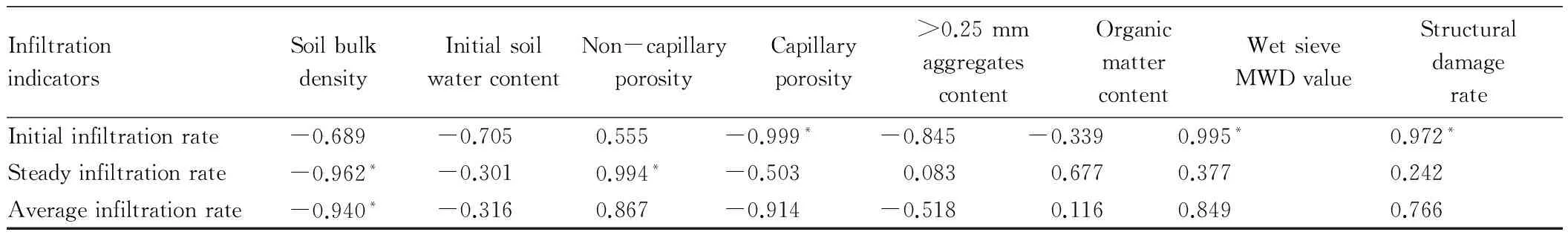
InfiltrationindicatorsSoilbulkdensityInitialsoilwatercontentNon-capillaryporosityCapillaryporosity>0.25mmaggregatescontentOrganicmattercontentWetsieveMWDvalueStructuraldamagerateInitialinfiltrationrate-0.689-0.7050.555-0.999*-0.845-0.3390.995*0.972*Steadyinfiltrationrate-0.962*-0.3010.994*-0.5030.0830.6770.3770.242Averageinfiltrationrate-0.940*-0.3160.867-0.914-0.5180.1160.8490.766
Note: * indicates that the correlation is significant at the 0.05 level (one-tailed).
4 Conclusions and discussions
4.1ConclusionsSoil water infiltration is always a hot spot of soil water movement research, and there are many studies on soil infiltration in the purple soil area, but due to different research methods and location, the results obtained are not the same[27-28]. A new infiltration method, point-source infiltration method is used to precisely evaluate the infiltration capacity in different purple soil land-use types. And correlation analysis on soil physical and chemical properties and soil infiltration capacity of different land-use types is performed. Results show that: (i) there is a large difference among soil physical and chemical properties in different land-use types, soil water content, non-capillary porosity, capillary porosity, content of > 0.25 mm aggregates and organic matter content in the top soil are greater than those in the subsoil; (ii) soil infiltration capacity shows differences among different land-use types. Land use shows great effects, in general, initial infiltration rate and average infiltration rate decrease in the order: woodland slope> slope farmland> grassland, steady infiltration rate decreases in the order: slope farmland>woodland> grassland and the time reaching stable state decreases in the order: slope farmland> woodland>grassland; (iii) correlation analysis shows that there is a significantly positive correlation between initial infiltration rate and wet sieve MWD value and structural damage rate, and it has a significantly negative correlation with capillary porosity; (iv) steady infiltration rate and non-capillary porosity show the significantly positive correlation, and it has a significantly negative correlation with the soil bulk density; (v) the average infiltration rate and non-capillary porosity and structural damage rate show a positive correlation and the correlation coefficient is large and there is a negative correlation between average infiltration rate and soil bulk density and capillary porosity, and the absolute value of correlation coefficient is relatively large. The results of this research can provide the theoretical basis for soil infiltration study in purple soil area.
4.2DiscussionsThe application of point source method in the purple soil area has not yet been reported, but owing to its advantages of easy use and high precision, it can play a good role in measuring the soil infiltration in the purple soil area. There is a need to avoid special places (street, potholes,etc.) and choose suitable determination time to reduce experimental error. In this experiment, we measure soil infiltration capability in the field, but this method is seldom applied in the field, so we need to gradually explore. There are many factors that affect soil infiltration, but we can not list them all due to limited experimental quantity. Moreover, there are great differences in the soil physical and chemical properties between different land use-types, and the physical and chemical properties are different for the same land-use type, so in the analysis of weight of factors influencing infiltration, the single variable was not controled well,so it was replaced by the average value. Therefore, it was possible with a few errors in the test results, then there was a need to conduct more thorough research.
[1] LEI TW, ZHANG QW, YAN LJ. The physical model ofrill erosion[M]. Beijing: Science Press, 2009: 105-120.(in Chinese).
[2] ZHENG CY, WANG SJ, OUYANG ZY. Using geochemistry as a tool measuring soil erosion[J]. Progress in Geography, 2002, 21(5): 507-516.(in Chinese).
[3] FANG S. Spatial variation of soil steady-state infiltration rates in Karst Hillslopes[D]. Beijing: University of Chinese Academy of Sciences, 2013.(in Chinese).
[4] MAO TX, ZHU YJ, SHAO MA,etal. Characteristics of runoff and infiltration in stony soils under simulated rainfall conditions[J]. Chinese Journal of Soil Science, 2011, 42(5): 1214-1218.(in Chinese).
[5] ZHAO JB, ZHANG HH,etal. Soil infiltration rule in Southern Shaliuhe Town of Qinghai Lake Area[J]. Journal of Mountain Research, 2013, 31(6): 693-700.(in Chinese).
[6] AN CZ, QU YH. The infiltration characteristics of soil moisture under different vegetations in Mayan mountainous region of Tiahang Mountain in Hebei Province[J]. The Journal of Hebei Forestry Science and Technology, 2013, (5): 14-15.(in Chinese).
[7] XIAO QL, HUANG MB,SHAO MA,etal.Infiltration and drainage processes of different textural soil moisture in middle reaches of Heihe River Basin[J]. Transactions of the Chinese Society of Agricultural Engineering, 2014, 30(2): 124-131.(in Chinese).
[8] QIN HJ, HE BH, ZHAO XC,etal.Influence of karst mountain under-forest economy modes on soil infiltration in Southwest China[J]. Chinese Journal of Eco-Agriculture, 2013, 21(11): 1386-1394.(in Chinese).
[9] LI JX, HE BH, CHEN Y. Root features of typical herb plants for hillslope protection and their effects on soil infiltration[J].Acta Ecologica Sinica, 2013, 33(5): 1535-1544.(in Chinese).
[10] LIU ZQ, HUANG XH, WANG KQ. Soil infiltration characteristics and its influencing factors of different forest soils in Jingshajiang dry-hot valley region[J]. Journal of Soil and Water Conservation, 2014, 28(2): 57-62.(in Chinese).
[11] LI XJ, HU ZQ, ZHANG GQ,etal.Soil water characteristic analysis of rice Field destroyed by coal mining in south-west mountain area[J]. Coal Mining Technology, 2011, 16(6): 48-50.(in Chinese).
[12] CHEN YK, SHAO F, QIAO ZY,etal. Vertical infiltration characteristics of reclaimed farmland soils with Yellow River sediment fill[J]. Chinese Journal of Eco-Agriculture, 2014, 22(7): 798-805.(in Chinese).
天子射熊,诸侯射麋,卿大夫射虎豹,士射鹿豕,示服猛也。名布为侯,示射无道诸侯也。夫画布为熊、糜之象,名布为或,礼贵意象,示义取名也。土龙亦夫熊糜、布侯之类。[13](P923)
[13] LIU JW, CHEN HS,ZHANG W,etal.Soil Water infiltration measurement by disc permeameter in Karst Depression[J]. Journal of Soil and Water Conservation, 2008, 22(6): 202-206.(in Chinese).
[14]CHEN SP, LI Y, FU QP,etal. Experimental of disk infiltration characteristics with different soil salt contents[J]. Transactions of the Chinese Society of Agricultural Engineering, 2010, 26(4): 36-41.(in Chinese).
[15] LI XF, HE WQ. Experimental study of disk infiltration characteristics with disc infiltrometer to measure soil water motion parameters[J]. Journal of Irrigation and Drainage, 2010, 29(5): 68-72.(in Chinese).
[16] SUN B, MA YY, LEI TW,etal. Method for continuously measuring soil infiltrability of plow-cultivated layer and hardpan in farmland[J]. Transactions of the Chinese Society of Agricultural Engineering, 2013, 29(4): 118-124.(in Chinese).
[17] XIE JB, YANG JH, LI HY. The research of soil infiltration in different outside factors[J]. Research of Soil and Water Conservation, 2004, 11(2): 115-117.(in Chinese).
[18] HUANG R,HUANG L, HE BH,etal.Characteristics of soil water infiltration under different biological regulation measures in Three Gorges Reservoir Region[J]. Journal of Southwest Agricultural University, 2013, 35(8): 119-126.(in Chinese).
[19] JIANG YL.Experimental study of the effect of soil aggregate water stability on the water movement processes[D].Yangling: NorthWestAgricultureandForestryUniversity, 2013.(in Chinese).
[21] DONG LL.Characteristics of soil water stable aggregates under different land-use types[J].Scientia Silvae Sinicae, 2011, 47(4): 95-100.(in Chinese).
[22] NI HB, ZHANG LP. Experimental study on slope infiltration process in abandoned soils in Shen-Dong Mine Region[J]. Journal of Soil and Water Conservation, 2007, 21(3): 28-31.(in Chinese).
[23] ZHU BB, ZHANG PC, WANG YF,etal. Research on regional variation of soil infiltration rates in up- and mid-stream areas of Changjiang River[J]. Journal of Yangtze River Scientific Research Institute, 2006, 23(6) : 32-34, 38.(in Chinese).
[24]ZAHNG ZW,ZHU ZX, WANG Y,etal.Soil infiltration capacity and its influencing factors of different land-use types in Karst slope[J]. Transactions of the Chinese Society of Agricultural Engineering, 2010, 26(6): 71-76.(in Chinese).
[25] HU JP, YANG JH, LUO MD,etal.Study on characteristics of soil infiltration of different forest types in Limestone Mountainous[J].Journal of Soil and Water Conservation, 2011, 25(3): 54-58.(in Chinese).
[26] XU XJ. Effect of seismic soil and water loss on soil and vegetation in Wenchuan earthquake area[D]. Chongqing: Southwest University, 2012.(in Chinese).
[27] WANG WD.The research of forest soil infiltration characteristics in the Three Georges Reservoir area[D]. Wuhan: Central China Normal University, 2013.(in Chinese).
[28] LIU C, WANG YK, FU B,etal. Rain infiltration experiment study under different land-use types of purple soil[J]. Research of Soil and Water Conservation, 2009, 13(3): 20-23.(in Chinese).
January 20, 2016 Accepted: March 17, 2016
Supported by National Science and Technology Support Program (2011BAD31B03); Fundamental Research Funds for Central Universities (XDJK2011C013).
*Corresponding author. E-mail: mobin666@163.com
猜你喜欢
杂志排行

Asian Agricultural Research的其它文章
- Evaluation of Social Vulnerability to Natural Disasters on a County Scale in Henan Province
- An Empirical Analysis of the Export Competitiveness of Agricultural Products in Hubei Province Based on Inter-provincial Comparison
- Changes and Influencing Factors of Maize Production Pattern in China
- The Changes in Guilin Paddy Soil Organic Matter and Rice Yield under Long-Term Fertilization
- Study on the Discipline Reputation of Agricultural Colleges and Universities
- Pricing Power of Agricultural Products under the Background of Small Peasant Management and Information Asymmetry