Evaluation of Social Vulnerability to Natural Disasters on a County Scale in Henan Province
2016-01-11,,,,
, ,, ,
1. Safety and Emergency Management Research Center, Henan Polytechnic University, Jiaozuo 45000, China; 2. School of Emergency Management, Henan Polytechnic University, Jiaozuo 45000, China
EvaluationofSocialVulnerabilitytoNaturalDisastersonaCountyScaleinHenanProvince
ShanfengHE1, 2*,LipingDU1,2,XiuhuaGAO1,2
1. Safety and Emergency Management Research Center, Henan Polytechnic University, Jiaozuo 45000, China; 2. School of Emergency Management, Henan Polytechnic University, Jiaozuo 45000, China
Social vulnerability evaluation is of important significance to analyzing risks of natural disasters to human society and economy. By using expert investigation and AHP method, 12 indicators from four aspects (population, economy, infrastructure and disaster prevention and mitigation capacity) are selected to assess social vulnerability to natural disasters on a county scale in Henan Province. The results show that the population vulnerability and economic vulnerability to natural disasters in the eastern region is generally higher than in the western region, while the areas with high infrastructure vulnerability are mainly located in the northwest; the disaster prevention and mitigation capacity in northwest is higher than in east and south, and this capacity of various districts is obviously higher than that of counties; in terms of the spatial pattern, social vulnerability to natural disasters is roughly higher in a belt from northeast to southwest, and lower on both sides of the belt. The results can provide scientific basis for disaster risk management and disaster prevention and mitigation planning in Henan Province.
Social vulnerability, Disaster prevention and mitigation ability, County scale, Henan Province
1 Introduction
The social vulnerability to natural disasters is a hot issue that today’s international community and academia pay widespread attention to, and the domestic and foreign scholars have launched a number of studies on it[1-9]. Cutter uses HOP conceptual model to analyze the impact of natural environment and social situation on vulnerability, thereby combining the risk concept in natural vulnerability research with resilience and coping capacity in social vulnerability research, and applying it to the specific geographic unit[1]. Brooksetal. believe that social vulnerability is the inherent property of system characteristics, and a state of system before the disasters[2]. Fekete uses the German flood case to discuss the spatial scale problems in social vulnerability assessment[4]. Birkman systematically classifies the typical definitions of vulnerability, and believes that social vulnerability mainly focuses on the extent of potential disasters when individuals (groups), organizations and society are exposed to adverse events as well as the coping ability related to the social, economic and cultural background[5]. The qualitative and quantitative studies on vulnerability conducted by Chinese scholars have also greatly promoted the development of disaster risk management. Shi Peijun thinks that vulnerability is an important part of disaster system, mainly depending on the regional economic development level and social security building level[6]. Zhao Weiquanetal. use principal component analysis and GIS to analyze the social vulnerability to natural disasters in Chongqing[7]. From population, economy, social structure and social culture, Cheng Xiaoyun builds the evaluation indicator system for the social vulnerability to natural disasters, and explores the space-time pattern of social vulnerability in 2000 and 2008 in Jiangsu Province[8]. Nie Chengjingetal. use the macroscopic and microscopic evaluation methods and models for population vulnerability to traditional seismic hazard, to assess the population vulnerability in various cities, districts and counties[9]. Based on the above studies, it can be found that social vulnerability is one of the important causes of natural disaster difference, and accurate evaluation of social vulnerability can effectively reduce the losses and the effects caused by natural disasters. Natural disasters have the dual properties of nature and society. It is generally believed that the natural disaster risks consist of two elements: natural disaster risk and social vulnerability[10]. The natural disaster risk assessment is to analyze the natural disasters risk from the disaster-inducing factors and disaster-forming environment; the social vulnerability can be broken down into the vulnerability of various elements at risk and disaster prevention and mitigation ability (Fig. 1). This article focuses on the analysis and assessment of social vulnerability elements of natural disasters. Henan is a province of the People’s Republic of China, located in the central part of the country. With an area of 167000 square kilometers, Henan covers a large part of the fertile and densely populated North China Plain. Henan has a diverse landscape with floodplains in the east and mountains in the west. Much of the province forms part the densely populated North China Plain, an area known as the "breadbasket of China". The Taihang Mountains intrude partially into Henan’s northwestern borders from Shanxi, forming the eastern edge of Loess Plateau. Henan has a temperate climate that is humid subtropical to the south of the Yellow River and bordering on humid continental to the north. It has a distinct seasonal climate characterized by hot, humid summers due to the East Asian monsoon, and generally cool to cold, windy, dry winters that reflect the influence of the vast Siberian anticyclone. Because of the special geographical conditions and meteorological factors, the natural disasters in Henan Province have characteristics of many types, high frequency, wide distribution and seasonality. In Henan, there are frequent natural disasters such as heavy rain, waterlogging, drought, high temperature, lightning strike and ground subsidence, and the disasters are serious in some areas, having a negative impact on the sustainable economic and social development in Henan Province. In this study, we use expert investigation method, AHP and geographic information system technology, and select 12 evaluation indicators from population, economy, infrastructure vulnerability and disaster prevention and mitigation ability, to assess the social vulnerability to natural disasters in Henan Province, and express the assessment results on a county scale, in order to provide a scientific basis for disaster prevention and mitigation planning and social sustainable development in Henan Province.
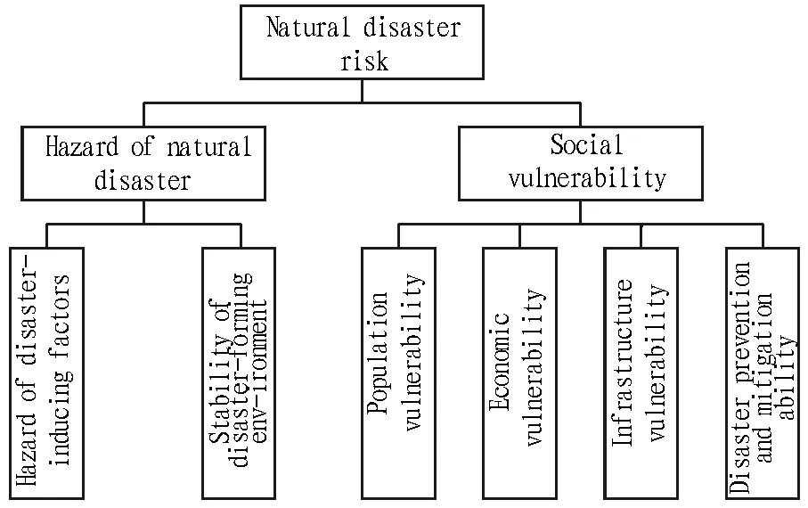
Fig.1 The natural disaster risk elements
2 The evaluation indicator system for social vulnerability to natural disasters
2.1IndicatorselectionThe indicators about social vulnerability to natural disasters are generally established based on the government’sStatisticalYearbookand other data officially announced by the government[11]. On the basis of the research results at home and abroad, this paper selects indicators following three principles: scientificity, pertinence and comparability. In addition, the indicator system has the following three features. (i) Correlation between various disasters. All kinds of natural disasters do not exist in isolation, and there is a certain complex response-linkage relationship[12]. The evaluation indicators selected in this paper are not for a specific disaster, and they are used to evaluate the comprehensive vulnerability of socio-economic system to natural disasters based on the socio-economic characteristics of Henan Province. (ii) Focusing on social factors. The natural disasters have both natural attributes and social attributes. The abnormal changes in natural environment may lead to natural disasters[13], but it is very difficult to change environmental factors, so it is believed that the key to reducing natural disaster risks lies in improving socio-economic factors. (iii) Focusing on disaster prevention and mitigation ability. The disaster prevention and mitigation ability of human society is an important factor affecting the occurrence of natural disasters and losses[14]. Disaster prevention and mitigation ability is an indispensable part of social vulnerability. Through the quantitative analysis, this paper aims to measure the impact of disaster prevention and mitigation ability on social vulnerability.
2.2EstablishmentofevaluationindicatorsystemanddeterminationofindicatorweightIn this paper, data mainly come fromStatisticalYearbookofHenanProvince(2013), and there are also data released by civil affairs departments and local government. According to indicator selection principle, characteristics and the relevant principles of natural disaster risk system, this paper selects 12 indicators from vulnerability of population, economy and infrastructure and disaster prevention and mitigation ability (see Table 1). In this paper, we use AHP combined with expert opinion to determine the weight of each evaluation indicator. The analytic hierarchy process (AHP) is a structured technique for organizing and analyzing complex decisions, based on mathematics and psychology. It was developed by Thomas L. Saaty in the 1970s and has been extensively studied and refined since then. Rather than prescribing a "correct" decision, the AHP helps decision makers find one that best suits their goal and their understanding of the problem. It provides a comprehensive and rational framework for structuring a decision problem, for representing and quantifying its elements, for relating those elements to overall goals, and for evaluating alternative solutions. It is especially for those complex problems difficult to be completely analyzed quantitatively[15]. The key to determining the weight value is to construct judgment matrix based on the relative importance of indicators. The weight of evaluation indicators for social vulnerability to natural disasters is determined, as shown in Table 1.
3 Evaluation methods for social vulnerability to natural disasters
3.1EvaluationmodelforsocialvulnerabilitytonaturaldisastersThe measurement units of various indicators are different and values vary in a wide range, so there is a need to normalize the various indicator data and make the value fall within the range[0, 1]. This paper uses the following formula to normalize the data:

(1)
whereXiis the value of an indicator after normalization;Niis the a city’s statistical data about this indicator;Nmaxis the maximum value of statistical data about this indicator in the cities.
According to the correlation between the selected evaluation indicator system and social vulnerability, this paper builds the following evaluation model for the social vulnerability to natural disasters on a county scale in Henan Province:
(2)
whereVis the comprehensive social vulnerability to natural disasters in Henan Province (the larger the value ofV, the greater the social vulnerability to natural disasters);wi(i=1,2, …, 12) is the weight of each indicator;Xi(i=1,2,…,12) is the value of each indicator after normalization.
3.2LevelsofsocialvulnerabilitytonaturaldisastersThis paper divides the social vulnerability to natural disasters in Henan Province into five levels: mild, low, medium, high and severe. Based on Reference[16], the specific grading methods are as follows: firstly, sequencing the index of social vulnerability to natural disasters on a county scale; secondly, grading the 126 counties (cities, districts) in the province based on the ratio of 1∶2∶4∶2∶1; finally, setting the number of counties at various levels at 13, 26, 48, 26 and 13, respectively. This grading method can dilute the impact of human subjectivity on grading standards to some extent.
4 Results
4.1PopulationvulnerabilityAs shown in Fig. 2 (a), the regions with high level of population vulnerability to natural disasters are mainly concentrated in the central and eastern part of Henan and some prefecture-level city areas; the Xinxiang City area has the highest population vulnerability, followed by the Zhengzhou City area, the Zhoukou City area, the Luoyang City area and Changyuan County. In the context of urbanization in recent years, China’s cities are quickly expanded, and the urbanization rate of Zhengzhou City and Xinxiang City is ranked first and third in the province, reaching 66.3% and 51.6%, respectively. A large number of people in rural areas flow to more developed cities, which leads to high population vulnerability in the districts under city administration with high population density. In addition, agriculture is the industry seriously affected by natural disasters, and when disaster comes in the regions with a large agricultural population, it will lead to a large number of people affected by disaster.
4.2EconomicvulnerabilityWith "Beijing-Guangzhou railway line" as boundary, there is a large difference in the economic vulnerability to natural disasters between the eastern and western regions of Henan, and the economic vulnerability in the eastern region is significantly higher than in the western region, as shown in Fig. 2 (b). In terms of single county unit, the economic vulnerability is highest in Yima City (west of Beijing-Guangzhou line), which is mainly related to its developed economy and small population. Yima has the highest per capita GDP in the province, reaching 111300 yuan, 3.53 times the provincial average. In addition to Yima, Qixian County, Shangshui County, Zhengyang County and Sui County also have high economic vulnerability, and the per capita GDP is not high in these counties, but the regional economy is highly dependent on the output value of primary industry. Zhengyang County (Zhumadian City) has the highest proportion of output value of primary industry to GDP in the province, reaching 39.28%, much higher than the provincial average; it is followed by Shangshui County (Zhoukou City) (37.25%), where crop acreage is also higher than that of most counties, and it is in line with the reality of Zhoukou City as a major agricultural city.
Table1TheevaluationindicatorsandweightsforsocialvulnerabilitytonaturaldisastersinHenanProvince
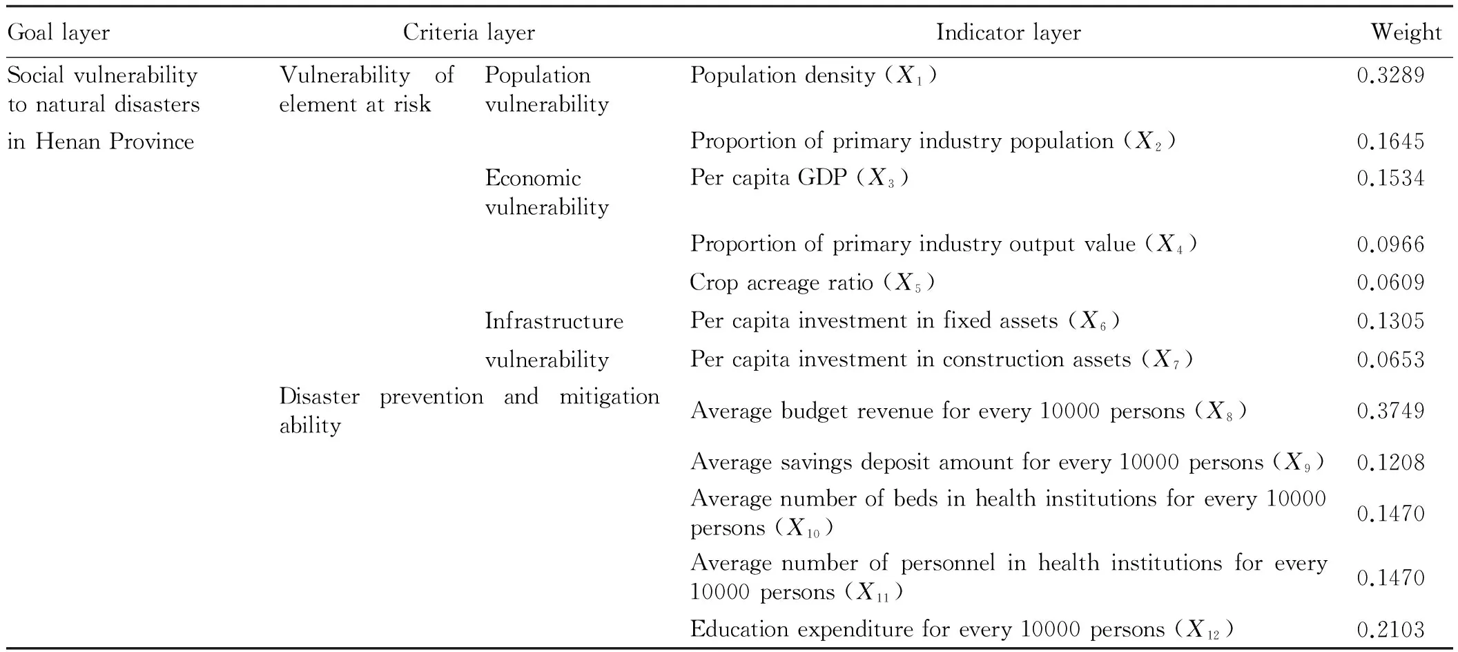
GoallayerCriterialayerIndicatorlayerWeightCorrelationSocialvulnerabilitytonaturaldisastersVulnerabilityofelementatriskPopulationvulnerabilityPopulationdensity(X1)0.3289+inHenanProvinceProportionofprimaryindustrypopulation(X2)0.1645+EconomicvulnerabilityPercapitaGDP(X3)0.1534+Proportionofprimaryindustryoutputvalue(X4)0.0966+Cropacreageratio(X5)0.0609+InfrastructurePercapitainvestmentinfixedassets(X6)0.1305+vulnerabilityPercapitainvestmentinconstructionassets(X7)0.0653+DisasterpreventionandmitigationabilityAveragebudgetrevenueforevery10000persons(X8)0.3749-Averagesavingsdepositamountforevery10000persons(X9)0.1208-Averagenumberofbedsinhealthinstitutionsforevery10000persons(X10)0.1470-Averagenumberofpersonnelinhealthinstitutionsforevery10000persons(X11)0.1470-Educationexpenditureforevery10000persons(X12)0.2103-
Note: "+" indicates the positive correlation between indicators and social vulnerability while "-" indicates the negative correlation between indicators and social vulnerability.
4.3InfrastructurevulnerabilityInfrastructure provides the general material conditions for survival and development of society, including water, electricity, oil, gas, telecommunications and other lifeline projects as well as highways, railways, bridges, airports and other public facilities, which are subject to natural disasters. As shown in Fig. 2 (c), Henan’s infrastructure vulnerability is mainly distributed in the northwest. From the indicators that affect the regional infrastructure vulnerability, since Yima City vigorously build one hundred billion yuan coal chemical industry cluster in recent years, the per capita investment in fixed assets was 88400 yuan in 2013, far higher than the provincial average of 23900 yuan, thus leading to the highest infrastructure vulnerability in Yima City, followed by the Luoyang City area, Changyuan County, the Zhengzhou City area and the Sanmenxia City area, which is related to great economic strength in these areas where urban infrastructure and economic construction is vigorously carried out in recent years.
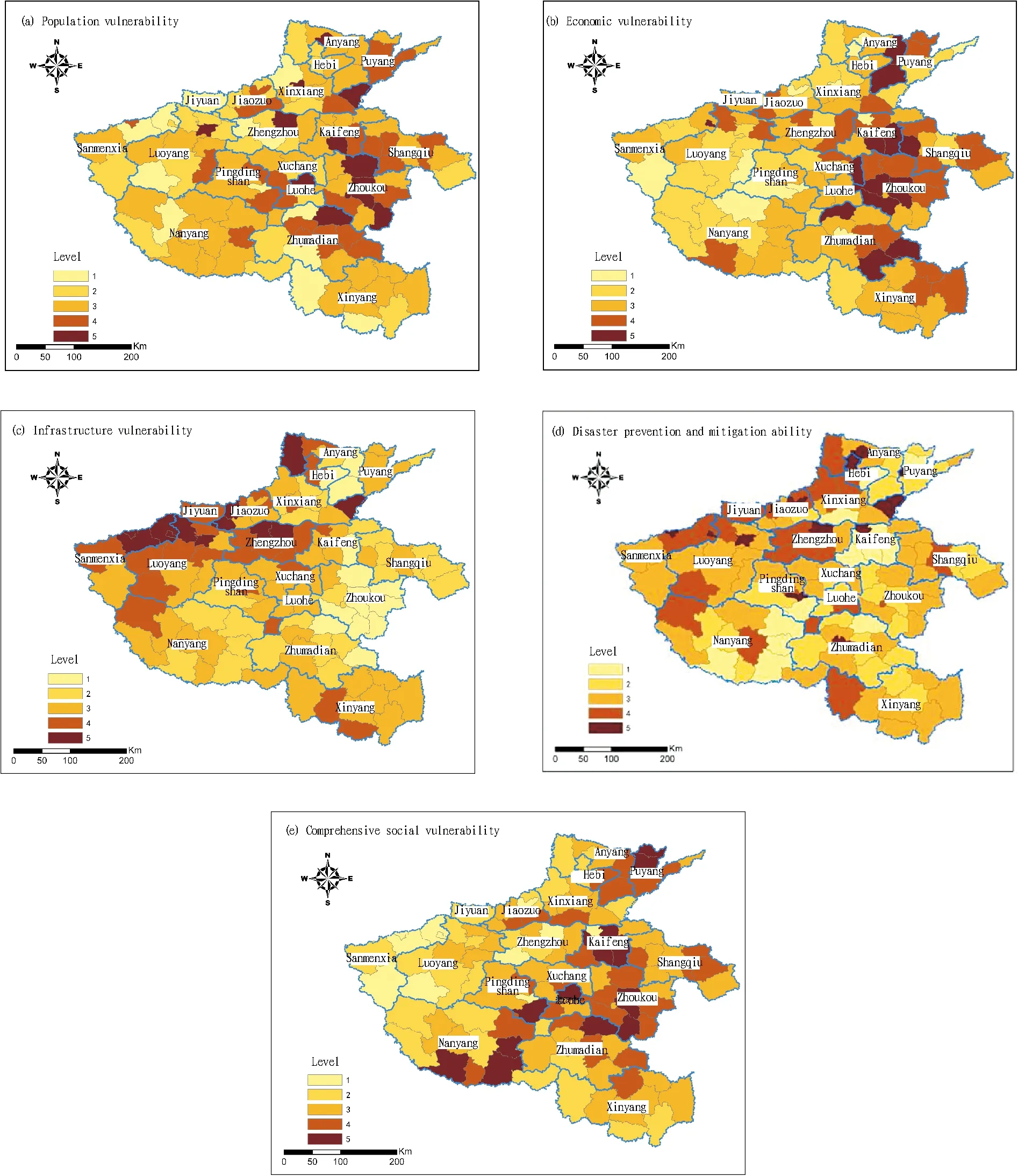
Fig.2 Spatial distribution about the level of some indicators in Henan Province
4.4DisasterpreventionandmitigationabilityThe disaster prevention and mitigation ability is the negative indicator of social comprehensive vulnerability, that is, the stronger disaster prevention and mitigation ability indicates the lower social vulnerability and the smaller loss caused by disasters[17]. As can be seen from Fig. 2 (d), the counties with high disaster prevention and mitigation ability in Henan Province are mainly distributed in the northwestern region and the prefecture-level city areas. The disaster prevention and mitigation ability in most districts is significantly higher than in counties, which is related to the level of economic development, health care and education in the districts under city administration. The Zhengzhou City area has the highest disaster prevention and mitigation ability, followed by the Sanmenxia City area, the Xuchang City area, the Yima City area and the Puyang City area. Zhengzhou is the capital city of Henan Province, and the province’s political, economic and cultural center. The economic and social development speed in the Zhengzhou City area is significantly higher than in other counties, and the government makes a large investment in finance, health and education. Various indicators are about 2 to 5 times the provincial average, so that the disaster prevention and mitigation ability in the Zhengzhou City area is at the highest level in the province. Yima City is a county-level city of Sanmenxia City, and its disaster prevention and mitigation ability is also very high, even higher than that of most municipal districts, mainly because Yima as a city based on coal industry makes a large investment in finance, health and education. The regions with high disaster prevention and mitigation ability have strong ability to cope with natural disasters, thereby better ensuring security of life and property.
4.5ComprehensivesocialvulnerabilityOn the basis of evaluation about vulnerability of population, economy and infrastructure coupled as well as disaster prevention and mitigation ability, according to the established evaluation model, we superimpose various indicator layers in ArcGIS, to get the spatial distribution of comprehensive social vulnerability to natural disasters in Henan Province, as shown in Fig. 2 (e). The comprehensive social vulnerability to natural disasters in Henan Province is high in "Northeast-Southwest" line, and low on both sides of the line. The regions with high social vulnerability are mainly concentrated in central and eastern Henan, and Qixian County has the highest social vulnerability, followed by Qingfeng County, Tongxu County and Shangcai County. On the one hand, there is a large proportion of workers and output value in primary industry in the above counties; on the other hand, these regions invest little in disaster prevention and mitigation, and the ability to respond to disasters is low when natural disasters come. In some northern regions such as the Zhengzhou City area and the Yima City area, the vulnerability of population, economy and infrastructure is high, but the comprehensive social vulnerability is not high due to high disaster prevention and mitigation ability. Clearly, the disaster prevention and mitigation ability has a profound impact on comprehensive social vulnerability.
5 Conclusions and discussions
Based on the basic theory of natural disaster risk system, this paper builds the evaluation indicator system and model for social vulnerability, analyzes the vulnerability of population, economy and infrastructure to natural disasters as well as disaster prevention and mitigation ability in Henan Province, and applies the evaluation results of comprehensive social vulnerability on a county scale in Henan Province to the space unit. It is found that in terms of the spatial pattern, social vulnerability to natural disasters is roughly higher in a belt from northeast to southwest, and lower on both sides of the belt. In addition, the disaster prevention and mitigation ability of most prefecture-level city areas is significantly higher than that of most counties. Conspicuously, enhancing the disaster prevention and mitigation ability can effectively reduce social vulnerability to natural disasters, so it is necessary to note this in the future disaster risk management and disaster prevention and mitigation planning of local government, which is consistent with the findings of Liu Yietal.[18]. Social vulnerability evaluation, as an analytical tool, can be used to predict what will happen to certain people or organizations in the scenario of disaster risk, in order to find the best way to reduce vulnerability and strengthen the adaptation of social groups to disasters[19]. The evaluation results of social vulnerability to natural disasters in Henan Province show that the evaluation results in this paper are in line with the actual disaster areas. However, social vulnerability is not easy to measure, and there are still many restrictions on quantitative research. Firstly, the selection of evaluation indicators is affected by data accessibility and social background factors; secondly, there is inevitably some human subjectivity in any method used to determine the indicator weight; thirdly, social vulnerability is dynamic, and evaluation of single time section social vulnerability can not well reflect the evolution characteristics and trends of regional social vulnerability. Although the social vulnerability study is facing these limitations, the evaluation of social vulnerability to disasters can provide a more creative perspective for disaster research, and promote disaster prevention and mitigation.
[1] CUTTER S. Social vulnerability to environmental hazards[J]. Social Science Quarterly, 2003, 84(2): 1-16.
[2]BROOKS N. Vulnerability, risk and adaptation: A conceptual framework[R]. Norwich, UK: Tyndall Centre for Climate Change Research, 2003.
[3]WISNER B, BLAIKIE P, CANNON T,etal. At risk: Natural hazards, people’s vulnerability and disasters[M]. London: Routledge, 2004.
[4]FEKETE A, DAMM M, BIRKMANN J. Scales as a challenge for vulnerability assessment[J]. Natural Hazards, 2010(55): 729-747.
[5]BIRKMANN J. Measuring vulnerability to hazards of national origin[M]. Tokyo: UNU Press, 2006.
[6]SHI PJ. Theory and practice on disaster system research in a fourth time[J].Journal of Natural Disasters, 2005, 14(6): 1-7. (in Chinese).
[7]ZHAO WQ, GUO Y. Analysis of hazard’s social vulnerability in Chongqing based on the principle component analysis method and GIS technology[J]. Research of Soil and Water Conservation, 2007, 14(6): 305-308. (in Chinese).
[8]CHENG XJ. Research on spatial-temporal pattern of the social vulnerability to natural disaster in Jiangsu Province[D]. Chongqing: Chongqing Normal University, 2011. (in Chinese).
[9]NIE CJ, YANG LS, LI HR. Macro assessment of seismic population vulnerability in China[J].Progress in Geography, 2012, 31(3): 375-382. (in Chinese).
[10] GE QS, ZOU M, ZHENG JY. A preliminary study on comprehensive assessment of natural disaster risk in China[M]. Beijing: Science Press, 2008. (in Chinese).
[11] ZHANG YL, YOU WJ. Assessment of social vulnerability to natural disasters of cities based on TOPSIS:A case study of Shanghai City[J]. Journal of Catastrophology, 2014, 29(1): 109-114. (in Chinese).
[12] YIN GE, XU SY. Study on the evaluation of urban natural disaster risk[M]. Beijing: Science Press, 2012. (in Chinese).
[13] ZHANG JQ, LI N. The quantitative method of the evaluation of main meteorological disaster risk and management and its application[M]. Beijing: Beijing Normal University Publishing Group, 2007. (in Chinese).
[14] ZHANG GC. Heavy rain flood disaster forecast and risk assessment[M]. Beijing: China Meteorological Press , 2012. (in Chinese).
[15] SAATY TL. The analytic hierarchy process[M]. New York: McGraw-Hill, 1980.
[16] HE SF, GE QS, WU SH,etal. Projecting spatio-temporal patterns of flood hazard over Anhui Province[J]. China Population. Resources and Environment, 2012, 22(11): 32-39. (in Chinese).
[17] JIAO SX, YUAN HH, LI Y,etal. Influence of urban economic development on the flood disaster-carrying capability --A case study of Anyang City, He’nan Province[J]. Research of Soil and Water Conservation, 2014, 21(2): 311-314. (in Chinese).
[18] LIU Y, HUANG JY, MA L. The assessment of regional vulnerability to natural disasters in China based on DEA model[J]. Geographical Research, 2010, 29(7): 1153-1162. (in Chinese).
[19] ZHOU LM. Social vulnerability: A new perspective for the study of sociology of hazards[J]. Journal of Nanjing Normal University (Social Science Edition), 2012(4): 20-28. (in Chinese).
November 10, 2015 Accepted: January 28, 2016
Supported by National Natural Science Foundation of China (71203057,71103058,41101460); Henan College Science and Technology Innovation Talent Support Program (Humanities and Social Sciences); Henan University Philosophy and Social Sciences Excellent Scholars Fund Project (2016-YXXZ-07); Young Scholar Fund of Henan Polytechnic University (649256).
*Corresponding author. E-mail: heshanfeng@163.com
杂志排行

Asian Agricultural Research的其它文章
- An Empirical Analysis of the Export Competitiveness of Agricultural Products in Hubei Province Based on Inter-provincial Comparison
- Changes and Influencing Factors of Maize Production Pattern in China
- The Changes in Guilin Paddy Soil Organic Matter and Rice Yield under Long-Term Fertilization
- Study on the Discipline Reputation of Agricultural Colleges and Universities
- Pricing Power of Agricultural Products under the Background of Small Peasant Management and Information Asymmetry
- Backflow of Migrant Workers in Urbanization: Place Selection and Influencing Factors