灾害性天气研究进展
2010-07-07
灾害性天气
灾害性天气研究进展
1. 灾害天气国家重点实验室通过科技部组织的评估
2010年4月受科技部委托,国家自然科学基金委员会组织专家对灾害天气国家重点实验室进行了评估。灾害天气国家重点实验室顺利通过科技部评估,并获得好评。评估专家对实验室的评估意见如下:灾害天气国家重点实验室紧紧围绕国家需求和学科前沿开展应用基础研究,抓住灾害天气监测与预测科学的前沿问题,开展灾害天气动力学理论的研究,灾害天气监测、预测新理论与新技术的研究,并致力于研究成果的业务应用,研究方向和科学目标定位明确。在本评估期内,在灾害天气中尺度结构与机理研究,灾害天气遥感监测新理论与新技术研究,灾害天气预测理论和方法的研究等方面取得了具有国际影响的研究成果,为我国灾害天气科学、气象部门业务建设和社会经济发展做出了重大贡献 。
2. 主要成果及其业务应用
(1)用CloudSat资料对比分析青藏高原-亚洲季风区和北美副热带地区夏季深对流
利用2006—2009年6—8月CloudSat卫星资料,对比分析了青藏高原、高原南坡、南亚季风区的深对流,进一步引入东亚、热带西北太平洋、北美西部和北美东部地区。研究发现,与发生在高原南坡和南亚季风区的深对流相比,青藏高原上深对流发生更加不频繁、深对流云顶和强回波顶更低,深对流系统的水平尺度也更小,这些说明高原上深对流活动相对更弱,这与其环境大气的对流零浮力层较低、水汽较少密切相关;7个地区相比,其中2个热带地区和4个副热带地区分别具有相似的深对流特征,但是热带和副热带相比有着显著差别;高原南坡的深对流表现出一定的独特性,这主要归因于其特殊的地形(陡坡)和低层潮湿的季风气流。
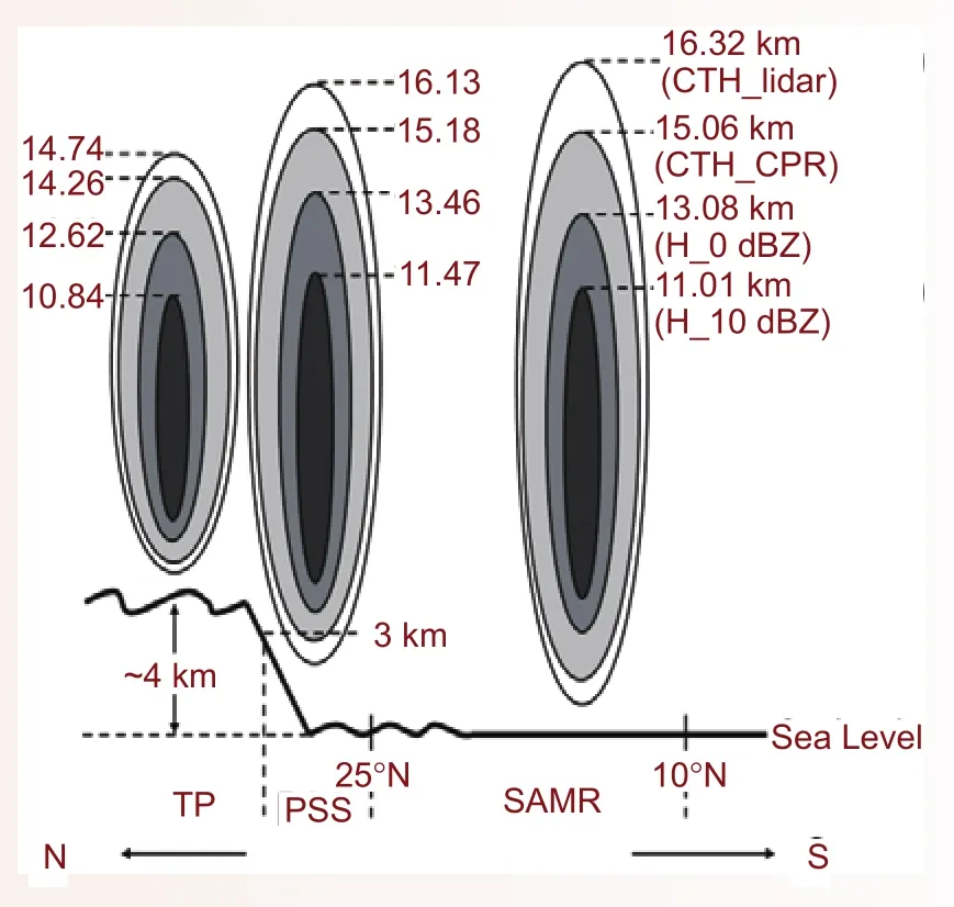
青藏高原(TP)、高原南坡(PSS)、南亚季风区(SAMR)深对流内部垂直结构示意Schematics of deep convection over the TP, PSS, and in SAMR
(2)星载毫米波雷达探测能力分析和毫米波雷达反演云参数方法研究
2010年,中国气象科学研究院灾害天气国家重点实验室的毫米波雷达在天津用于检验我国发展的星载毫米波雷达原理样机,并在吉林省与云参数探测飞机进行了联合观测。开展了地基雷达和机载雷达对比分析方法研究,发展了综合利用毫米波雷达回波强度、径向速度和速度谱宽反演层状云降水参数的方法。

2010年9月17日14∶26 毫米波雷达观测结果:(a)回波强度Z(dBZ)、垂直速度Vr(m/s)和速度谱宽Sw(m/s);(b)反演的云参数:滴谱数密度N0(个/m3),液态水含量M(g/ m3);(c)粒子中值半径R0(μm)和用对数表示的谱宽σXObserved (a) reflectivity Z(dBZ), velocity Vr(m/s)and spectrum Sw(m/s)width by cloud radar, (b) retrieved cloud drop concentration N0(个/m3),liguid water content M (g/ m3) and (c) median radius R0(μm)and logarithmic spread of the distribution σX at 14∶26, September 17, 2009
(3)C波段偏振雷达质量控制技术及其在降水估测中的应用
利用外场试验观测到的数据,对实验室购置的车载双偏振天气雷达(PCDJ)的系统误差及误差来源进行了深入分析。发展了一套差传播相移(ΦDP)的质量控制算法,能够从中计算得到高分辨率的差传播相移率(KDP)数据。利用KDP对反射率因子及差分反射率因子进行衰减订正后,雷达数据质量有了明显的改进。根据质量控制后的偏振雷达数据,综合ZH 与KDP估测降水强度R(ZH,KDP),并与地面雨量计实测降水强度R(gauge)进行比较分析表明,与传统的Z–R关系法估测的降水强度R(ZH )相比,当降水强度大于5 mm/h时,偏振雷达的降水估测精度有明显提高。
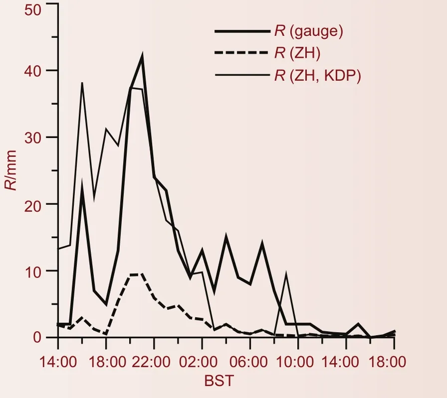
2008年8月22日14∶00至23日18∶00,珠海上川岛站(区站号:59673)实际观测降水量与ZH /KDP - R综合法、Z–R关系法估测降水量对比曲线The rainfall circles of R(gauge), R(ZH) and R(ZH,KDP) in observatory (station code∶ 59673) from 14∶00 BST 22 to 18∶00 BST 23 Aug 2008
(4)自动调整Z-R关系和反距离加权插值法改进雷达估测降水的方法研究
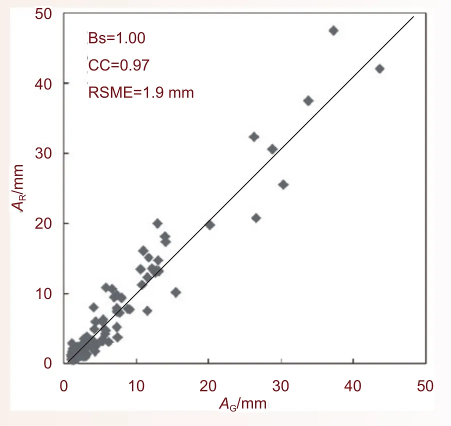
雷达估测降水的误差不仅是由于各种随机噪声而使估测存在系统性平均偏差,也存在雷达在各个估测点上误差不一致的问题。本研究提出了雷达估测降水的两步校准法,即对雷达观测的降水先采用拟合Z-I关系法在时间域上对雷达-雨量计的系统性平均偏差进行校准,然后再采用反距离加权插值校准法在空间上做第2次校准,实现对雷达-雨量计观测误差的两步校准,最大程度地减小雷达-雨量计之间的观测误差。利用2010年江淮流域暴雨过程的雷达和雨量计资料对上述方法进行评估的结果表明,两步校准法不仅改善了雷达对强降水的低估,而且减小了与雨量计观测的误差。
(5)青藏高原天气气候影响机理研究
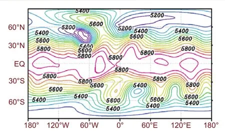
研究发现,从春季到夏季,青藏高原—黄土高原地气温差高值区西南—东北向的扩展过程与梅雨带东南—西北向的推进具有一致性,提出中国大地形可能是梅雨降水的重要驱动力。细致分析了2008年中国南方雨雪冰冻灾害的大气动力、热力特征,并建立了物理图像概念模型。结果表明,夏季亚洲季风区内穿越对流层顶高度的质量输送主要源于以青藏高原南侧为代表的南亚季风区,这进一步强调了青藏高原及其周边区域在全球对流层向平流层质量输送(TST)过程中的重要地位。

中国区域3—7月梅雨带(红色曲线)和地气温差(蓝色曲线)的逐月移动示意,其中彩色阴影为地形高度,R3,R4,…,R7指示了梅雨带边界(用150 mm<月降水量<200 mm的站点分布来代表)3—7月的变化,△T3,△T4,…,△T7则指示了地气温差高值区从3—7月的推进过程China’s topographic distribution (color-shaded), monthly movements of Meiyu rainbands (red curves), and monthly movements of land-atmosphere temperature difference (blue curves). R3, R4,…, R7denote boundaries of 150-200 mm total monthly rainfall amount, and△T3, △T4, …, △T7denote boundaries of land thermal forcing, respectively, from March, April, to July
(6)球面重力波的特征线快速求解
重力波快波的处理在很大程度上限制了数值模式的积分效率,通常在模式中采用隐式方法计算来放大时间步长。利用流体中波动和流动的同一性本质,通过黎曼变换将重力快波转换为流动的统一形式考虑,就可以和流动一样采用半拉格朗日方法计算重力快波的传播,不受计算线性稳定性的约束,从而提高高分辨模式的计算效率。图中给出了浅水波模式计算地形重力波的大时间步长(克朗数C=1.5)的第15天结果.
新开发球面重力快波特征线算法给出的地形重力波(Williamson试验5)Gravity wave solved with the characteristic method (CFL=1.5) in Williamson test 5
Severe Weather
Achievements in Disastrous Weather
1 The State Key Laboratory of Severe Weather has passed the evaluation check organized by the Chinese Ministry of Science and Technology
In April 2010, authorized by the Ministry of Science and Technology of China, National Natural Science Foundation of China convened some experts to give an evaluation check to the State Key Laboratory of Severe Weather (LaSW). The LaSW has passed the check and obtained a favorable evaluation.The evaluation panel has produced the following results and comments: the State Key Laboratory of Severe Weather (LaSW) works on applied basic research topics, in line with the national needs and cutting-edge developments in the area, including the major issues conf ning severe weather monitoring and prediction, theoretical study of severe weather dynamics, new theories and techniques for severe weather monitoring and forecast. In addition, LaSW has made efforts to turn research findings into something applicable to operational needs, under a clearly defined orientation and objective. During the period of evaluation, LaSW achieved a range of research results of international implications, including severe weather mesoscale structures and associated mechanisms, novel remote sensing theories and techniques for monitoring severe weather, and improved severe weather forecast theories and techniques. The efforts have rendered laudable contributions to the capacity building of China’s severe weather study and associated operations, and to the socio-economic development in the country as well.
2 Major accomplishments and applications
(1) Intercomparison of deep convection over the Tibetan Plateau-Asian monsoon region and subtropical North America in boreal summer using CloudSat data
Deep convection in the Tibetan Plateau-southern Asian monsoon region (TP-SAMR) was analyzed using CloudSat data for the boreal summer season from 2006 to 2009. Three subregions were defined - the TP, the southern slope of the plateau (PSS), and the SAMR - and deep convection properties were compared among these subregions. To cast them in a broader context, four additional regions are also discussed: East Asia, tropical northwestern Pacific, and western and eastern North America. The major findings are as follows: (1) Compared to the other two subregions of the TP-SAMR, deep convection over the TP is shallower, less frequent, and embedded in smaller-size convective systems, but the cloud tops are more densely packed. These characteristics of deep convection over the TP are closely related to the unique environment, namely, a signif cantly lower level of neutral buoyancy and much drier atmosphere. (2) In a broader context in which all seven regions are brought together, deep convection in the two tropical regions is similar in many regards. A similar conclusion can be drawn among the four subtropical continental regions. However, tropical oceanic and subtropical land regions present some significant contrasts.(3) Deep convection over the PSS possesses some uniqueness of its own because of the distinctive terrain (slopes) and moist low-level monsoon f ow.
(2) The observational capability examination and microphysical parameters retrieval by cloud radar
In 2010, ground-based Ka band cloud radars in State Key Laboratory of Severe Weather, Chinese Academy of Meteorological Sciences was used to examine the observational capability of the principle prototype spacebased cloud radar in Tianjin, and to observe cloud and precipitation systems with airplane in Jilin Province. The comparison algorithm between different wavelength radars, ground-based and airborne radars were developed. The ref ectivity, velocity and spectrum width observed by cloud radar in vertical observation model were used to retrieve the liquid water content and the size distribution in stratiform cloud.
(3) A quality assurance procedure and evaluation of rainfall estimates for C-band polarimetric radar
Using the observation data collected in field experiments, the mobile C-band dual polarimetric weather radar J type (PCDJ) systematic error and its sources were analyzed in depth. Meanwhile an algorithm that can smooth down differential propagation phase (ΦDP) for estimating the high-resolution specif c differential phase (KDP) was developed. After attenuation correction of reflectivity in horizontal polarization (ZH) and differential reflectivity (ZDR) of PCDJ radar by means of KDP, the data quality was improved signif cantly. Using quality-controlled radar data, quantitative rainfall estimation was compared with rain-gauge measurements. A synthetic ZH /KDP-based method was analyzed. The results suggest that the synthetic method has the advantage over the traditional ZH-based method when the rain rate is >5 mm/h. The more intensive the rain rates, the higher accuracy of the estimation.
(4) Improvement of radar quantitative precipitation estimation based on real-time adjustments to Z-R relationships and inverse distance weighting correction schemes
The errors of radar quantitative precipitation estimations consist not only of systematic bias caused by random noises, but also spatially non-uniform bias in radar rainfall at individual rain gauge stations.A two-step correction technique of radar quantitative precipitation estimations is proposed. To minimize the errors between radar quantitative precipitation estimations and rain gauge observations, a real-time adjustment to the Z-R relationship scheme is used to remove systematic bias on the time-domain. The gauge corrected by radar-based estimates scheme is then used to eliminate non-uniform errors in space. Based on radar data and rain gauge observations near the Huaihe River, the two-step correction technique was evaluated through heavy precipitation cases. The results show that the proposed scheme could be improved not only in the underestimation of rainfall, but also in reducing the root mean-square error and mean relative error of radar–gauge pairs.
(5) Study of the impact on weather and climate of the Tibetan Plateau
The research results show that the cascade of western China’s elevated lands toward the northeast seems to act as a ‘‘dynamic attractor’’ that causes the Meiyu rainband to move to the northwest. Analyses of precipitation, water vapor, difference of temperatures between Earth’s surface and near-surface air, and atmospheric circulation provide a clear picture of this land –ocean-atmosphere interaction.
In the winter of 2008, China experienced once-in-50 years (or once-in-100 years for some regions) snow and ice storms. These cases were revisited and comprehensive analyses of the storms’ dynamic and thermodynamic structure were conducted. Then the physical pictures of the large-scale dynamic and thermodynamic structures of the snowstorms were obtained.
We also found that in the Asian monsoon regions and summer, the mass transportation from the tropopause layer to the stratosphere was dominated by the South Asian monsoon region, represented by south of the Tibetan Plateau. This emphasized the importance of the Tibetan Plateau and its adjacent areas in the troposphere to stratosphere transport (TST) over the world.
(6) Characteristic solver for gravity wave on sphere
Model eff ciency and steps are rigidly restricted in the computation of rapid gravity wave. Implicit integration is usually used to expand model time steps. By means of the identical nature of flow and wave, gravity wave is transformed to f ow representation with a Riemann characteristic method. The wave transportation is then calculated the same as flow with the semi-Lagrangian algorithm, and therefore no limitation to the steps exists in terms of linear computational stability. High computational efficiency is then achieved for the rapid waves. An example for the topographical gravity wave is shown in the f gure, which is a 15-day integration of a shallow water model.
