Sedimentary facies and lithologic characters as main factors controlling hydrocarbon accumulations and their critical conditions
2015-08-20JunQingChenXiongQiPangDongXiaChen
Jun-Qing Chen,Xiong-Qi Pang,Dong-Xia Chen
aState Key Laboratory of Petroleum Resources and Prospecting,China University of Petroleum(Beijing),Beijing 102249,China
bBasin and Reservoir Research Center,China University of Petroleum(Beijing),Beijing 102249,China
cUnconventional Natural Gas Institute,China University of Petroleum(Beijing),Beijing 102249,China
Keywords:Sedimentary facies Lithologic characters Hydrocarbon accumulation Hydrocarbon threshold Hydrocarbon exploration
ABSTRACT Taking more than 1000 clastic hydrocarbon reservoirs of Bohai Bay Basin,Tarim Basin and Junggar Basin,China as examples,the paper has studied the main controlling factors of hydrocarbon reservoirs and their critical conditions to reveal the hydrocarbon distribution and to optimize the search for favorable targets.The results indicated that the various sedimentary facies and lithologic characters control the critical conditions of hydrocarbon accumulations,which shows that hydrocarbon is distributed mainly in sedimentary facies formed under conditions of a long lasting and relatively strong hydrodynamic environment;95%of the hydrocarbon reservoirs and reserves in the three basins is distributed in siltstones, fine sandstones,conglomerates and pebble-bearing sandstones;moreover,the probability of discovering conventional hydrocarbon reservoirs decreases with the grain size of the clastic rocks.The main reason is that the low relative porosity and permeability of fine-grained reservoirs lead to small differences in capillary force compared with surrounding rocks small and insuf ficiency of dynamic force for hydrocarbon accumulation;the critical condition for hydrocarbon entering reservoir is that the interfacial potential in the surrounding rock(Φn)must be more than twice of that in the reservoir(Φs);the probability of hydrocarbon reservoirs distribution decreases in cases where the hydrodynamic force is too high or too low and when the rocks have too coarse or too fine grains.
1.Introduction
Different sedimentary facies develop in different structural units of basins,different characters of lithologic rocks develop in different sedimentary facies,and different porosity and permeability develop in different rocks.The mechanism and enrichment of hydrocarbon accumulation in reservoirs with different porosity and permeability vary in petroliferous basins.It is of great significance to study the main factors controlling hydrocarbon accumulations and their critical conditions to reveal the hydrocarbon distribution and to optimize the search for favorable targets.
Based on the study of the hydrocarbon characteristics of more than 1000 clastic hydrocarbon reservoirs of Bohai Bay Basin,Tarim Basin and Junggar Basin,China,it is indicated that the sedimentary facies and lithologic characters are the main controlling factors for hydrocarbon accumulation.Hydrocarbon is distributed mainly in delta sandstone facies formedunder conditionsof a long lasting and relatively strong hydrodynamicenvironment;fewhydrocarbonreservoirs were discovered in alluvial-fan conglomerates under too strong hydrodynamic conditions,whereas they were not discovered in mudstone facies because they developed under too weak hydrodynamic conditions.Statistical analysis shows that in the three basins,95%of the hydrocarbon reservoirs and reserves are distributed in siltstones, fine sandstones,lithified gravels and pebble-bearing sandstones,accounting for 27%,45%,13%and 10%,respectively;their grain sizes were between 0.1 mm and 0.5 mm,and the probability of conventional hydrocarbon accumulation decreases with the diminishing grain size.Besides,the critical conditions and the probability of hydrocarbons distribution were analyzed.The critical condition for hydrocarbon entering reservoir is that the interfacial potential in the surrounding rock(Φn)must be more than twice of that in the reservoir(Φs);the probability of hydrocarbon reservoirs distribution decreases in cases where the hydrodynamic force is too high or too low and when the rocks have too coarse or too fine grains.
2.Controlling factors of hydrocarbon accumulation
2.1.Sedimentary facies
The issue of sedimentary facies controlling hydrocarbon accumulation has been widely discussed(Feng,1994;Gu and He,1994;Miall,1984;Wu and Xue,1993;Zhao,2001).Sedimentary facies controlling hydrocarbon accumulation refers to reservoir having high porosity and permeability favorable for hydrocarbon accumulation.The identification of favorable sedimentary facies then guides efforts to identify the distribution of favorable exploration areas in sedimentary basins.Reservoir formed in different sedimentary facies is signi ficantly different in clastic composition,structure,particle size,sorting,and single-layer thickness.Thus,it is clear that their original reservoir conditions were different.The better the original reservoir condition,the more easily was the reservoir changedtoformhigh-porosityandpermeabilityareas.Therefore,favorable sedimentary facies are often associated with high porosity and permeability reservoir(Ma et al.,1999;Yao et al.,2000;Zhang et al.,2004;Zhao et al.,2008).Reservoir with high porosity and permeability is a prime area for hydrocarbon accumulation.Hydrocarbon exploration and experiences show that the palaeo-sedimentary environment controlled the formation and distribution of hydrocarbon reservoirs around the world(Tian and Zhang,1996).In different sedimentary facies, the accumulation and preservation conditions were different owing to differences in the sedimentary environment;therefore,the study of hydrocarbon accumulations controlled by sedimentary facies is highly significant for predicting favorable hydrocarbon accumulation areas and improving exploration efficiency.
2.1.1.Bohai Bay Basin
Sedimentary facies types and the characteristics of rift basins control reservoir scales,distribution positions,properties,hydrocarbon reservoirs types,and hydrocarbon accumulation conditions(Wang and Wang,1997).Clastic sedimentary facies of Dongying Depression of Bohai Bay Basin mainly include alluvial fan, fluvial,fan delta,nearshore subaqueous fan,shore and shallow lake beach,delta,and turbidite fan.The sedimentary facies and hydrocarbon reservoirs distribution are shown in Figs.1-4.Studies of the relationship between sedimentary facies and reservoirs show that the favorable sedimentary facies for hydrocarbon accumulation are arranged as follows(from poor to favorable):turbidite fan,delta,nearshore subaqueous fan, fluvial,shore and shallow lake beach,and fan delta.
In Neogene of western Liaohe Depression of Bohai Bay Basin,sedimentary facies are mainly fan delta,delta in Paleogene,meandering river,and braided river.Statistical results show that western Liaohe Depression mainly developed six types of sedimentary facies and thirteen types of sedimentary subfacies and that hydrocarbon reservoirs distribution was controlled by sedimentary facies,which was quite evident.At present,most of the discovered hydrocarbon reservoirs are distributed in the fan delta front(Figs.5 and 6),and the hydrocarbon reservoirs of Neogene are mainly distributed in the river and flood subfacies.The distributary channel sand bodies of the fan delta front has good sorting,high maturity,good porosity,and permeability,and in addition,the horizontal and vertical extent of the sand bodies is large,and can be overlapped,especially at the slope.The fan delta source can cover hundreds of square kilometers and have regional caprocks with Member 3 and Member 1 of the Shahejie Formation,which became the most favorable hydrocarbon accumulation areas.
2.1.2.Tarim Basin
In the Tarim Basin,sedimentary facies mainly are dominated by tidal flat and shore facies.Statistical results clearly show that the hydrocarbon reservoirsdistribution was controlled by sedimentary facies(Figs.7 and 8).At present,most of the discovered hydrocarbon reservoirs are distributed in the foreshore-shoreface,estuary,tidal flat,shelf,and delta facies(Fig.9).Carboniferous hydrocarbon reservoirs are mainly distributed in the foreshore-shoreface,estuary,and shelf shallow sea(Fig.7),and Silurian hydrocarbon reservoirs are mainly distributed in the tidal flat and delta facies(Fig.8).
2.1.3.Junggar Basin
In the Jurassic strata of Junggar Basin,sedimentary facies were mainly developed as river-delta-shore-shallow lacustrine facies,and only locally as alluvial fan and beach-bar facies(Fig.10).Statistical results show that most of the discovered hydrocarbon reservoirs are distributed in delta facies,and that the delta front was the most favorable facies for hydrocarbon accumulation in the hinterland of Junggar Basin(Figs.10 and 11).
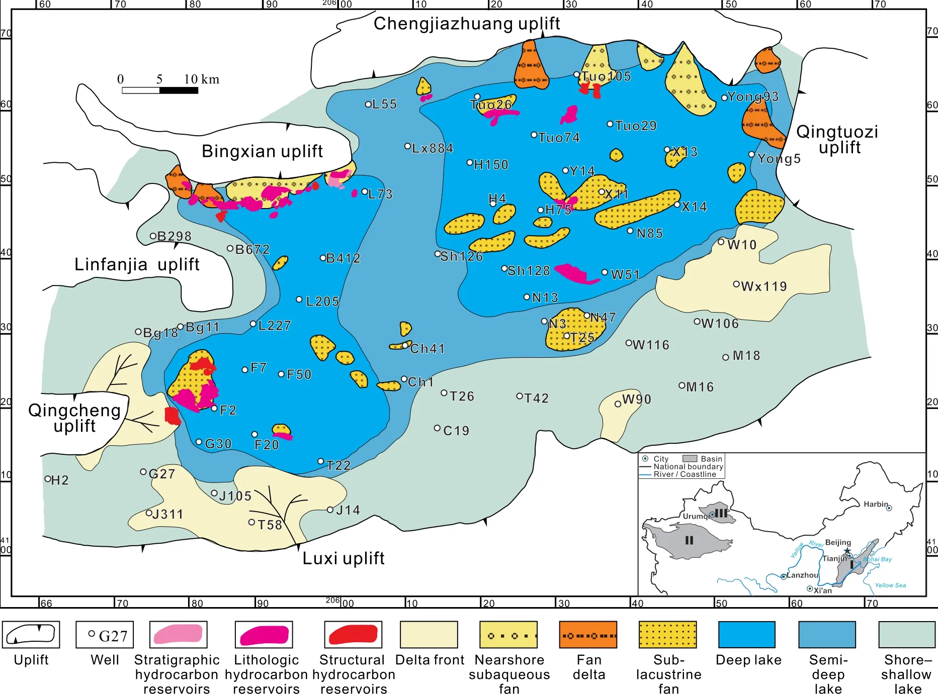
Fig.1-Distribution of sedimentary facies and hydrocarbon reservoirs in the lower submember of Member 3 of the Shahejie Formation in Dongying Depression,Bohai Bay Basin.World geodetic system(WGS-84)is used for coordinates.Simplified China map(northern part)is modified after the map(No.GS(2008)1010),composed by the National Administration of Surveying and Mapping in 2008;in which,I=Bohai Bay Basin,II=Tarim Basin,and III=Junggar Basin.
2.1.4.Hydrocarbon distribution in different sedimentary facies
According to the analysis of the hydrocarbon of different sedimentary facies in the three basins,hydrocarbon is mainly distributed in the delta sandstone facies in long lasting and relatively strong hydrodynamic environments.Furthermore,the sedimentary facies can never be an alluvial fan under a long lasting and really strong hydrodynamic environment where only very coarse sand or mudstone is formed,nor a deep lake under a weak hydrodynamic environment where only fine siltstone or clay with fine particles is formed.
In general,few hydrocarbon reservoirs and reserves have been discovered in the sedimentary facies under relatively strong hydrodynamic environments such as alluvial fan and subaqueous fan;few hydrocarbon reservoirs and reserves have been discovered in the sedimentary facies under relatively weak hydrodynamic environments such as lagoons,deep lakes,and shallow lakes;while most hydrocarbon reservoirs are distributed in sedimentary facies under medium hydrodynamic conditions,such as delta and fan delta facies(Fig.12).
2.2.Lithologic characters
Lithologic characters controlling hydrocarbon accumulation in clastic reservoirs and grain size,sorting,and interstitial material content are important factors affecting hydrocarbon.Under ideal conditions,the larger the median grain size and the better the sorting,the higher is the compositional and textural maturity,and the more hydrocarbon can accumulate.Zeng and Wang(2000)conducted a physical simulation experiment in which the results showed that when the grain size of a sand body reaches a certain critical value,there is hydrocarbon accumulation.Therefore,this indicates that grain size is crucial for controlling hydrocarbon accumulation.
2.2.1.Bohai Bay Basin
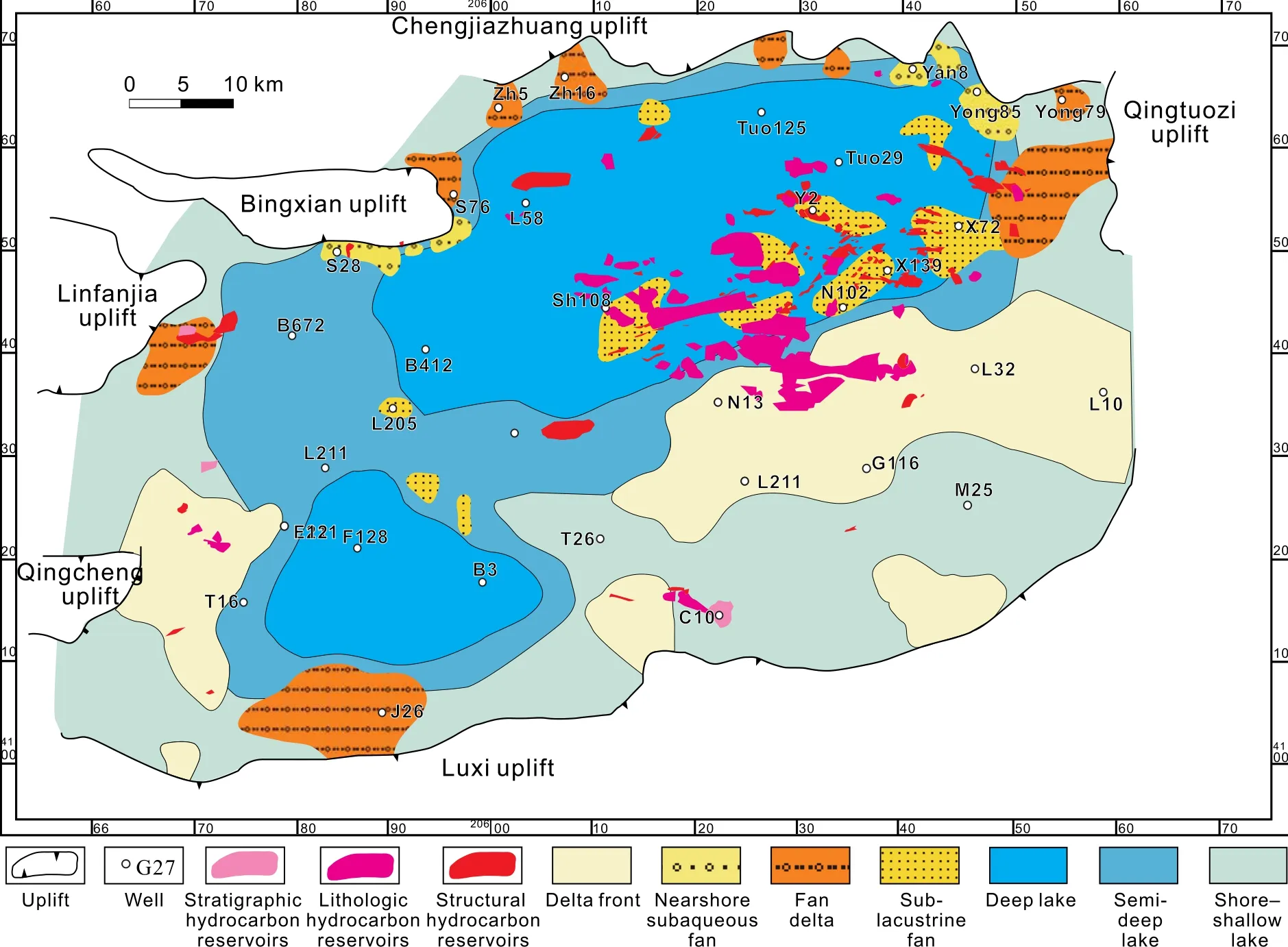
Fig.2-Distribution of sedimentary facies and hydrocarbon reservoirs in the middle submember of Member 3 of the Shahejie Formation in Dongying Depression,Bohai Bay Basin.World geodetic system(WGS-84)is used for coordinates.See Figure 1 for the basin location.
Statistical results of 267 hydrocarbon reservoirs in Dongying Depression of Bohai Bay Basin indicate that the rock types of hydrocarbon reservoirs can be muddy siltstone,siltstone, fine sandstone,medium sandstone,coarse sandstone,pebbly sandstone,and even conglomerate(Fig.13).However,of the total number of hydrocarbon reservoirs in the distribution,most of the hydrocarbon reservoirs were in siltstone,silt- fine sandstone, fine sandstone,and medium sandstone.The median grain size in the hydrocarbon reservoirs was between 0.1 mm and 0.5 mm(Fig.14).
In western Liaohe Depression of Bohai Bay Basin,the rocks of the reservoir mainly include siltstone, fine sandstone, finemediumsandstone,pebbly sandstone,and conglomerate.The statistical resultsforthehydrocarbonreservoirs showthatthe number and reserve of discovered hydrocarbon reservoirs were over 92%and 82%,respectively,in fine sandstone,medium sandstone,pebble-bearing sandstone,pebbly sandstone,and conglomerate(Fig.15),which are all favorable for hydrocarbon accumulation.
2.2.2.Tarim Basin
In Tarim Basin,the rocks of the reservoir mainly included muddy siltstone,siltstone, fine sandstone,coarse sandstone,and conglomerate.Statistical results show that more than 90%of the hydrocarbon reservoirs were distributed in siltstone and fine sandstone,and only approximately 10%of hydrocarbon reservoirs was distributed in conglomerate(Fig.16).The median sizes of grains in the hydrocarbon reservoir were between0.1 mm and 0.5 mm.The sorting of the sandstone was mainly medium to good and the particle roundness was mainly subangular or subrounded(Zhao et al.,2007a).
2.2.3.Junggar Basin
In Junggar Basin,the rocks of the reservoir mainly included muddy siltstone,coarse sandstone, fine sandstone,medium sandstone,gritstone,and conglomerate.Statistical results show that the discovered hydrocarbon reservoirs were mainly distributed in fine and medium sandstone in the abdominal area of Junggar Basin(Fig.17),and that the median sizes of grains in the hydrocarbon reservoir were between 0.1 mm and 0.5 mm.
2.2.4.Hydrocarbon distribution related to different lithologic characters
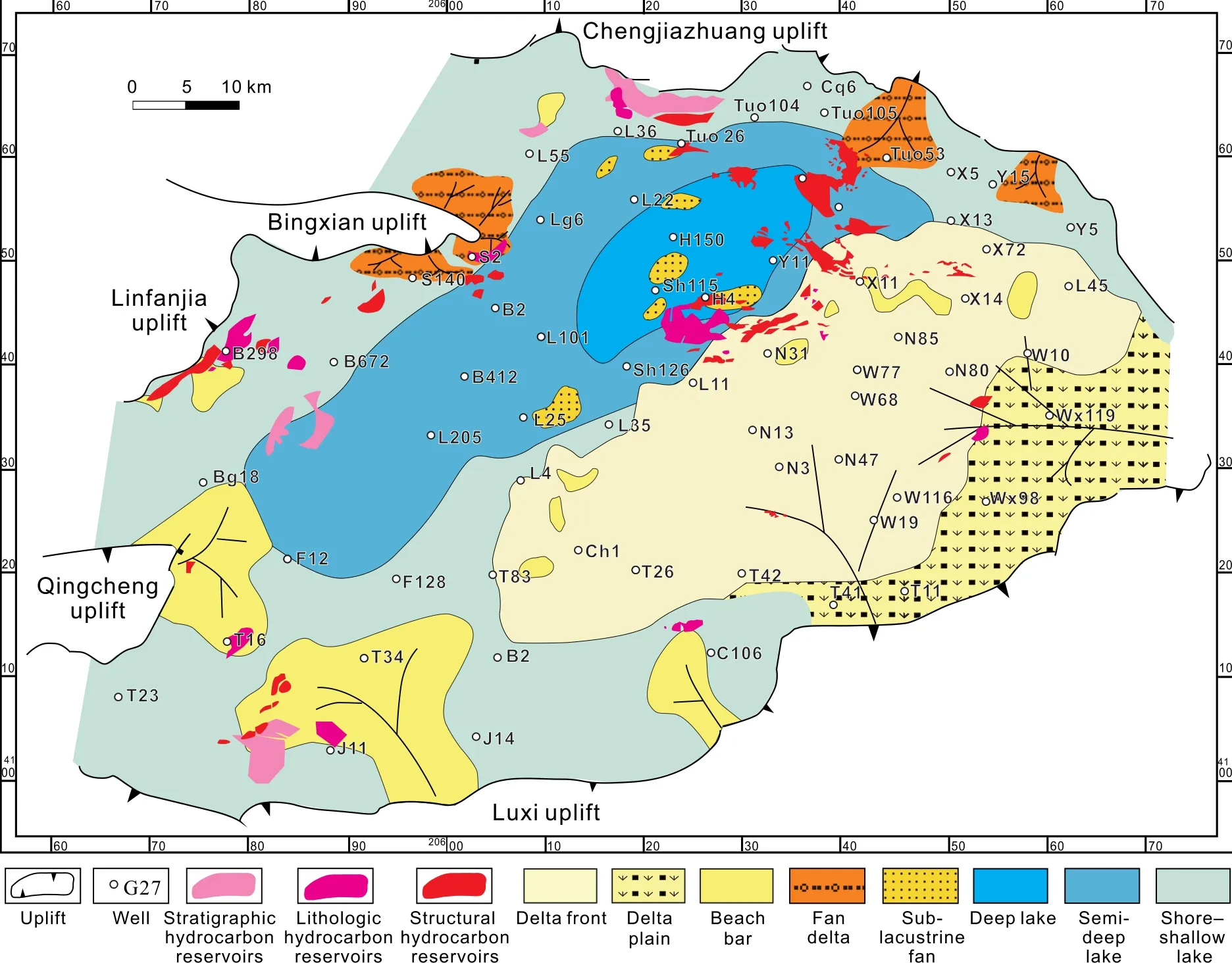
Fig.3-Distribution of sedimentary facies and hydrocarbon reservoirs in Member 1 of the Shahejie Formation in Dongying Depression,Bohai Bay Basin.World geodetic system(WGS-84)is used for coordinates.See Figure 1 for the basin location.
According to the analysis of the hydrocarbon with different lithologic characters in the three basins,hydrocarbon is mainly distributed in siltstone and fine sandstone.Statistical analysis shows that more than 95%of the number and reserves of hydrocarbon reservoirs are distributed in siltstone,fine sandstone,coarse sandstone,and conglomerate,which account for 27%,45%,13%,and 10%,respectively,in Bohai Bay Basin,Tarim Basin,and Junggar Basin(Fig.18).Their grain diameters are between 0.1 mm and 0.5 mm(Fig.19).Their clastic particle sizes are equal,the sorting is good,and the compositional maturity is high.They distribute in a wide area laterally.Vertically,there are intercalations of mudstone layer,showing show a rhythmic development.Finally,the porosity and permeability are high,which is good for hydrocarbon accumulation.
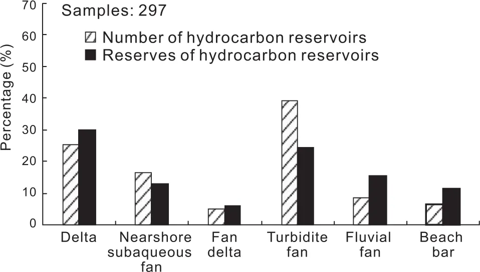
Fig.4-Characteristics comparison of different sedimentary facies controlling hydrocarbon in Dongying Depression,Bohai Bay Basin.
3.Critical conditions of controlling factors
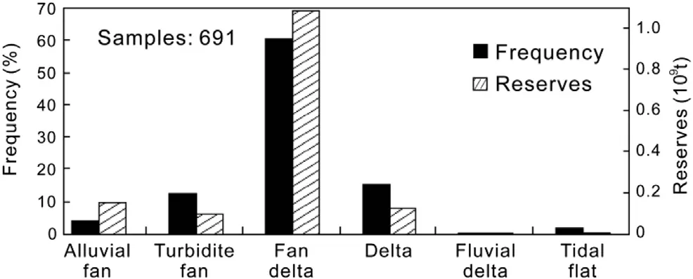
Fig.5-Characteristics comparison of different sedimentary facies controlling hydrocarbon in western Liaohe Depression,Bohai Bay Basin.
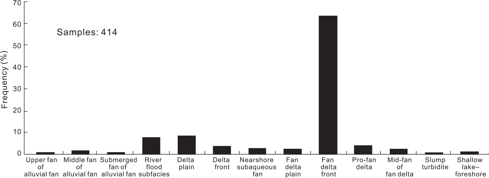
Fig.6-Characteristics comparison of different sedimentary subfacies and hydrocarbon reservoirs discovered in western Liaohe Depression,Bohai Bay Basin.
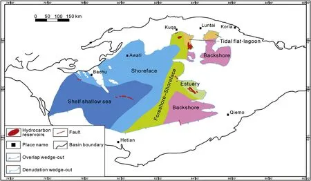
Fig.7-Distribution of sedimentary facies and hydrocarbon reservoirs in the Carboniferous in Tarim Basin.See Fig.1 for the basin location.
Results from geological statistical analyses on the critical conditions of lithologic characters controlling hydrocarbon accumulation show that in a clastic rock reservoir,hydrocarbon does not accumulate in strata with clastic grains of too fine or too coarse size.Few hydrocarbon reservoirs nor reserves are found in muddy siltstone and mudstone with small grain sizes because of their low porosity and permeability.For the same reason,few hydrocarbon reservoirs nor reserves are found in conglomerate and coarse-grained sandstone with largegrain sizes,which indicates that thereare,in fact,critical conditions controlling hydrocarbon accumulation.
Studies into the porosity and permeability of each rock type showthatwith increasinggrainsize,porosityandpermeability first increase and later decrease.A high-quality reservoir was neitherthe finestsiltstonenorthecoarsestconglomerate,butit was the fine sandstone.The larger the particle size,the larger the porosity and permeability distribution range and the more the ratio and reserve of a hydrocarbon reservoir are dispersed.Statistical results show that with increasing porosity and permeability,oil saturation gradually increases;however,the hydrocarbon reserves do not follow this rule.
According to the large-sphere theory,porosity is related not only to particle size but also to its accumulation mode.Sneider et al.(1977)studied the relationship between particle size,sorting,and porosity by using the Pennsylvanian reservoir data of the Elk City Oil field(Fig.20).Results from this study indicated that fine-to-coarse sandstone(median grain size was between 0.125 mm and 0.5 mm)yielded the best reservoir on account of its excellent sorting;although the sorting of mudstone and siltstone(with median grain size less than 0.125 mm)was also good,the grain size was small and the reservoir was in poor quality.Although the grain size of the coarse sandstone and conglomerate was large(median size was over 0.5 mm),both sorting and reservoir were poor.
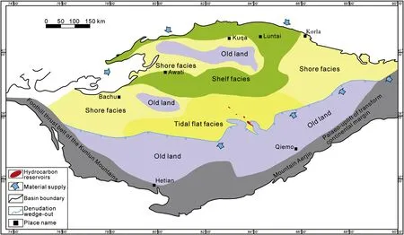
Fig.8-Distribution of sedimentary facies and hydrocarbon reservoirs in the Silurian in Tarim Basin.See Fig.1 for the basin location.
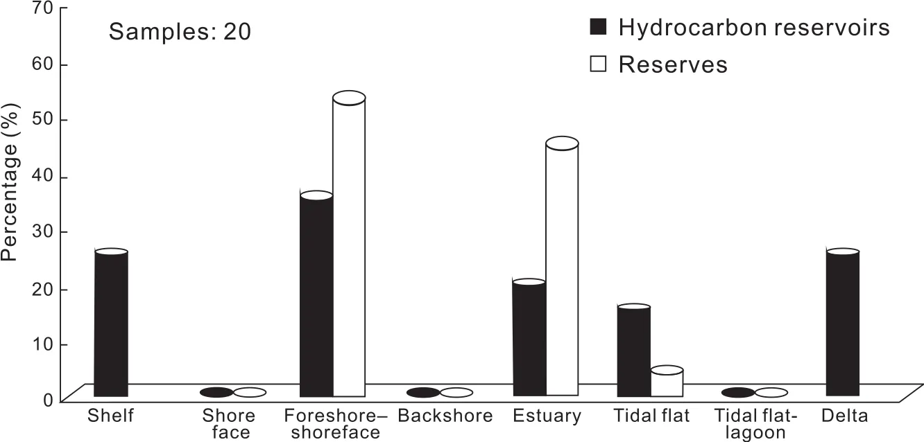
Fig.9-Characteristics comparison of different sedimentary facies and hydrocarbon reservoirs and reserves discovered in Tarim Basin.
For a poor sorting clastic reservoir such as muddy siltstone and silty- fine sandstone,owing to the small particles filling in the large pores,the porosity was not only related to this arrangement but also associated with the clastic content of the different grain sizes.When the content of small particles was high,a basic framework of small particles would be formed,while coarser particles had a dispersed distribution;when the content of small particles was low,a framework of coarse particles would be formed,which was then filled in by small particles.If the sorting was worse,the pores between the coarser particles would be filled by small particles,which greatly reduced the reservoir property.When the particles crossed two spatial lithologic areas,forming poorly sorted sandstone,the reservoir property got worse.Porosity and permeability were low in most of the conglomerates,but were high in fine sandstone-siltstone and low in coarse sandstone.
3.1.Hydrocarbon distribution in rocks with relatively high porosity and permeability
Hydrocarbon is distributed in strata with high porosity and permeability.Although porosity and permeability is gradually reduced during the burial process,the stratum maintains its relatively high porosity and permeability to a certain depth,and is always more favorable than surrounding rock with regard to hydrocarbon accumulation.
3.1.1.Change of the critical properties of effective reservoir in different structural units
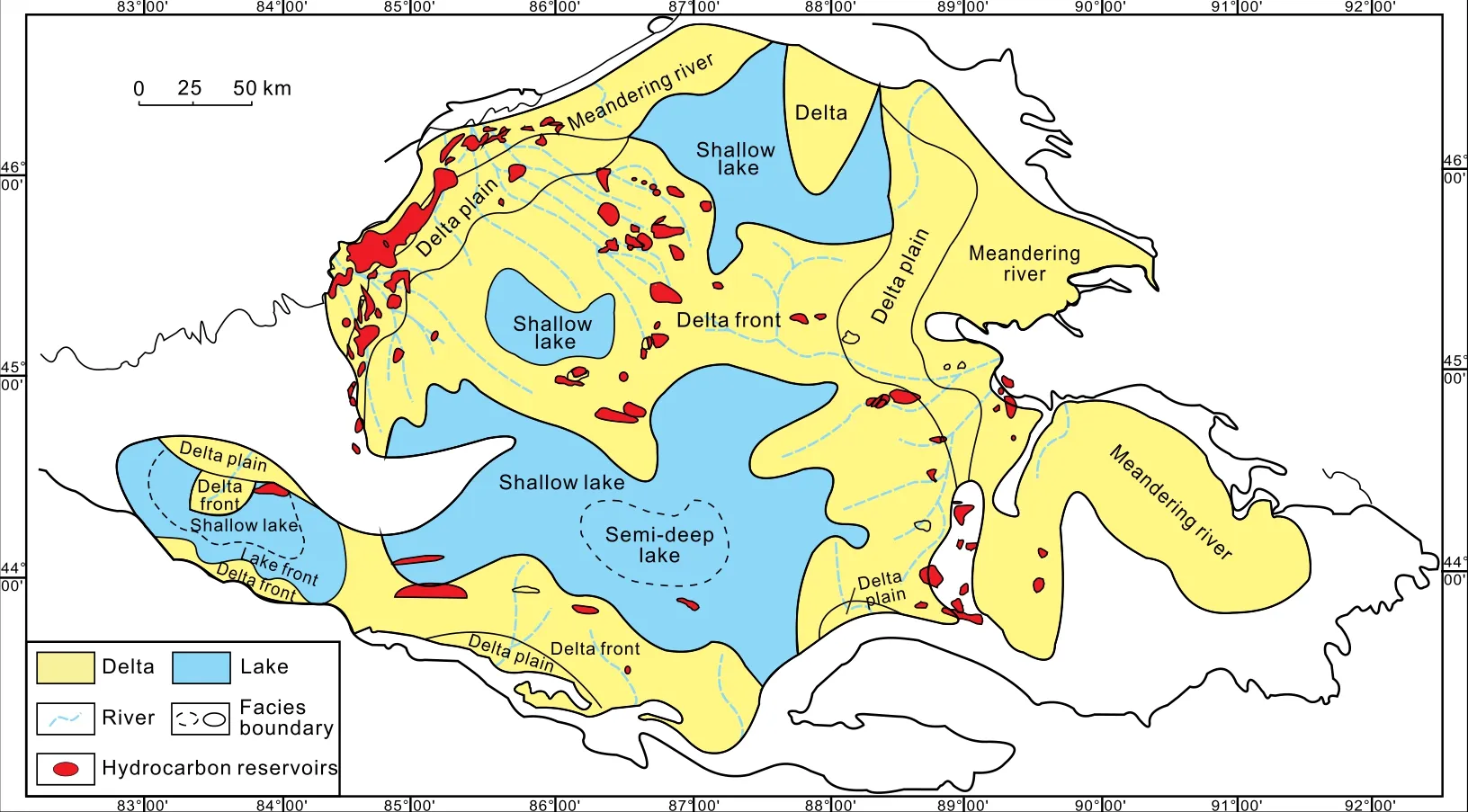
Fig.10-Distribution of sedimentary facies and hydrocarbon reservoirs in the Jurassic in Junggar Basin.See Fig.1 for the basin location.
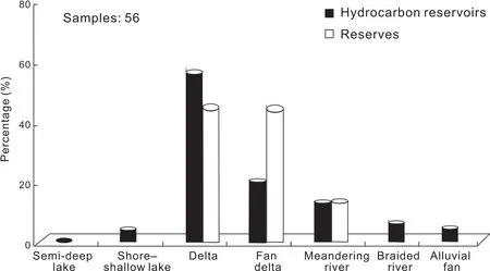
Fig.11-Characteristics comparison of different sedimentary facies and hydrocarbon reservoirs and reserves discovered from the Jurassic in Junggar Basin.
Porosity change characteristics of the hydrocarbon reservoirs of Dongying and western Liaohe Depressions of Bohai Bay Basin were analyzed and combined with the average porosity change with depth,and the result of this analysis indicates that the lower limit of porosity of effective reservoirs decreases as depth increases(Fig.21).At the same time,at a certain depth,the porosity of the oil layer is relatively high,and the higher the porosity,the more favorable is it for accumulation of hydrocarbon.
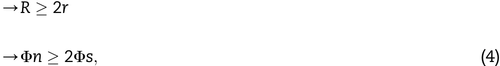
Critical properties of the lower limit of hydrocarbon layers decrease with the depth increased in the different structural units of the same depression.The relationship between the porosity of the hydrocarbon reservoirs and depth was studied(Fig.22).Using Dongying Depression of Bohai Bay Basin as an example,ananalysisofthecharacteristicsoftheporosityof133 hydrocarbon reservoirs of the northern slope belt change with increasing depth found that the lower limit of porosity decreases as the depth increases.More specifically,the critical value of porosity decreased from 20%at a depth of 1000 m to 10%at a depth of3500m.Italso follows the samepattern in the 135hydrocarbonreservoirsinthesouthernslopebelt,inthe571 hydrocarbon reservoirs in the central anticline belt,and in the 197 hydrocarbon reservoir in the depression belt in Dongying Depression.Because geological conditions differ at these sites,the critical values of porosity also differ at the same depths.
3.1.2.Change of the critical properties of effective reservoirs with different sedimentary facies
Different structures develop different types of sedimentary facies in a depression,and the sedimentary facies consequently have different physical properties.Studies show that the critical properties of hydrocarbon-bearing reservoir in these sedimentary facies decrease with increasing burial depth(Fig.23).At the same time,the porosity of the hydrocarbon-bearing reservoirs is highest when compared with other layers at the same depth,which again validates the rule that higher porosity is beneficial to hydrocarbon accumulation.For different sedimentary facies,the critical value of hydrocarbon-bearing porosity is different at the same depth.For example,reservoir of fluvial facies are mainly distributed in mid-shallow sections from 1000 m to 2000 m.The lower limit of the critical value of porosity at a depth of 1000 m is 22%.As depth increases,the rate at which the inferior limits reduce slows down.The inferior limit is 12%at a depth of 3000 m and is 10%at a depth of 4000 m.Reservoir of submarine fan facies are mainly distributed between 1500 m and 3300 m,and reservoir of delta facies is mainly distributed between 1500 m and 3000 m.The variation trends of the inferior limits for submarine fan facies and delta facies change with burial depth,as in the case of fluvial facies.Turbidite fan facies,mainly distributed in depression belts and abyssal regions,have deeper burial depths between 2300 m and 3500 m,and accordingly,have lower porosity.However,the fact that the inferior limit of critical property of a reservoir decreases with increasing burial depth holds true.
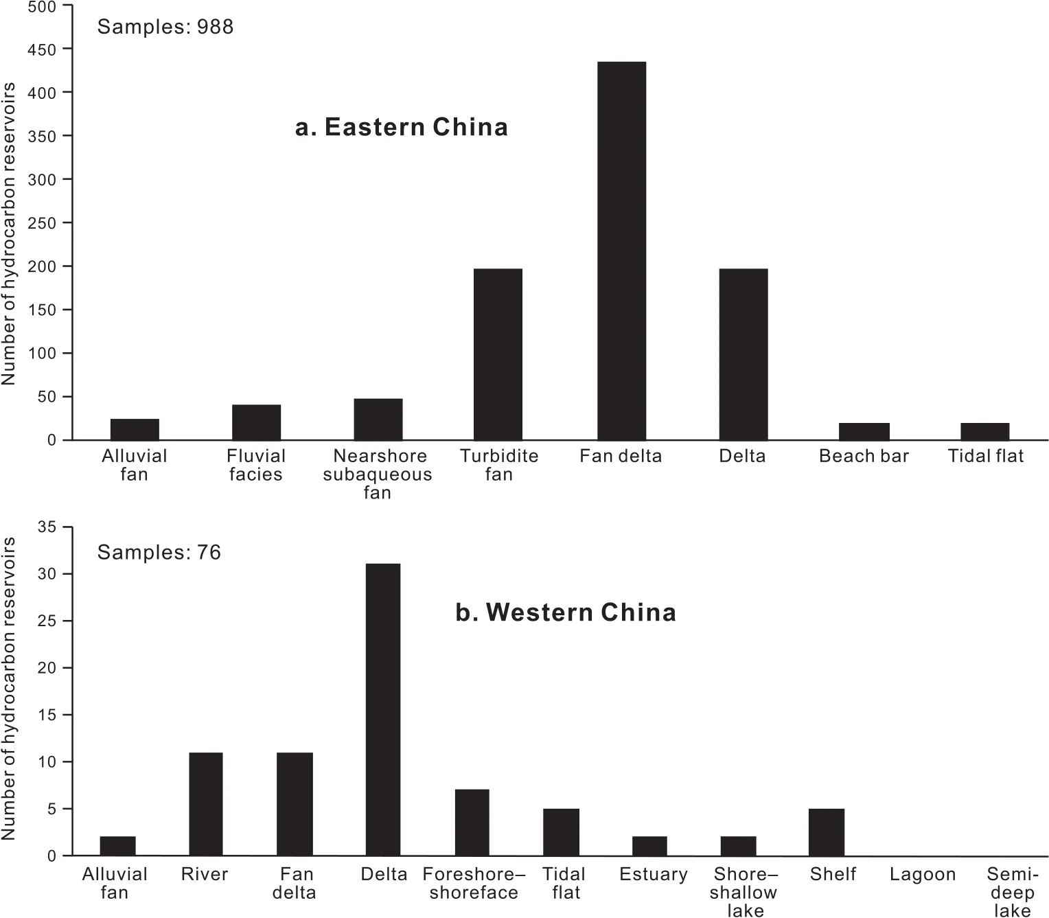
Fig.12-Relationship between sedimentary facies and hydrocarbon reservoirs in eastern and western China.
3.1.3.Change of the critical properties of effective reservoir with different lithologic characters
The porosity of different types of rocks bearing hydrocarbon decreases with burial depth in Dongying depression.At the same time,the porosity of hydrocarbon-bearing reservoir is highest in comparison with other layer types at the same depth,which once again validates that higher porosity is beneficial to hydrocarbon accumulation.The lithology of the reservoir in Dongying Depression includes muddy siltstone,siltstone, fine sandstone,medium sandstone,coarse sandstone,and pebble-bearing sandstone.However,according to studies of the reservoir distribution,most of the reservoir lithology is siltstone,silty sandstone, fine sandstone,and medium sandstone.Reservoirs of pebble-bearing sandstone are few in number,and the porosity decreases from 35%in the shallow section at 900 m to 10%in the deep section at 3500 m.Coarse-medium sandstone shows the same trend in that the inferior limit of the porosity decreases from 30%at a depth of 1000 m to 12%at a depth of 3500 m.The numbers of reservoir of fine sandstone and siltstone are the greatest,where the porosity can be close to 40%in reservoir with fine sandstone.With increasing burial depth,the porosity decreases and the inferior limit value of porosity at a depth of 3000 m is 10%.The burial depth of siltstone is less than 1000 m,and the inferior limit value of the critical porosity is 24%.As burial depth increases,the inferior limit value decreases to 10%at a depth of 3200 m(Fig.24).
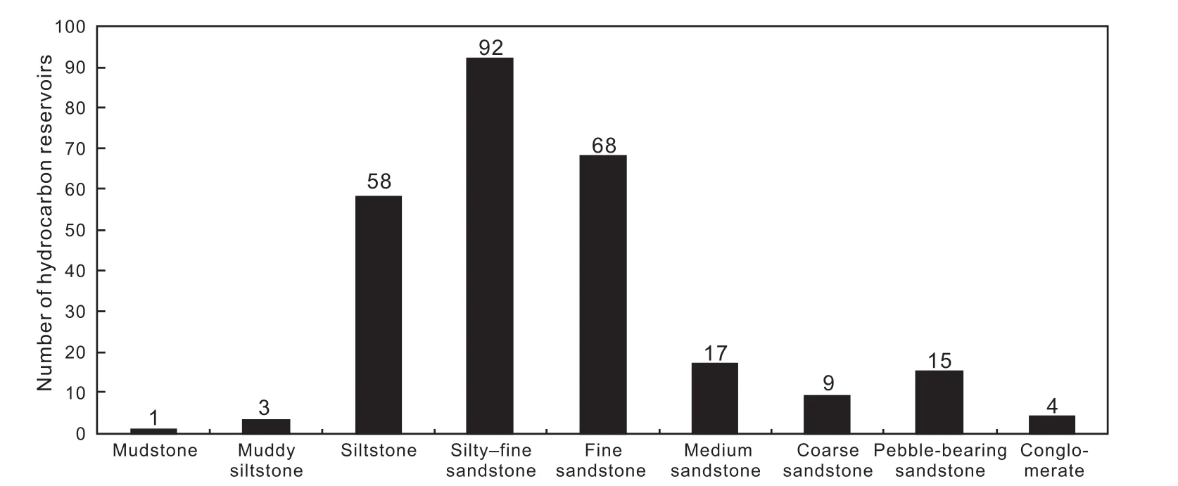
Fig.13-Distribution of rock types and hydrocarbon reservoirs discovered in Dongying Depression,Bohai Bay Basin.
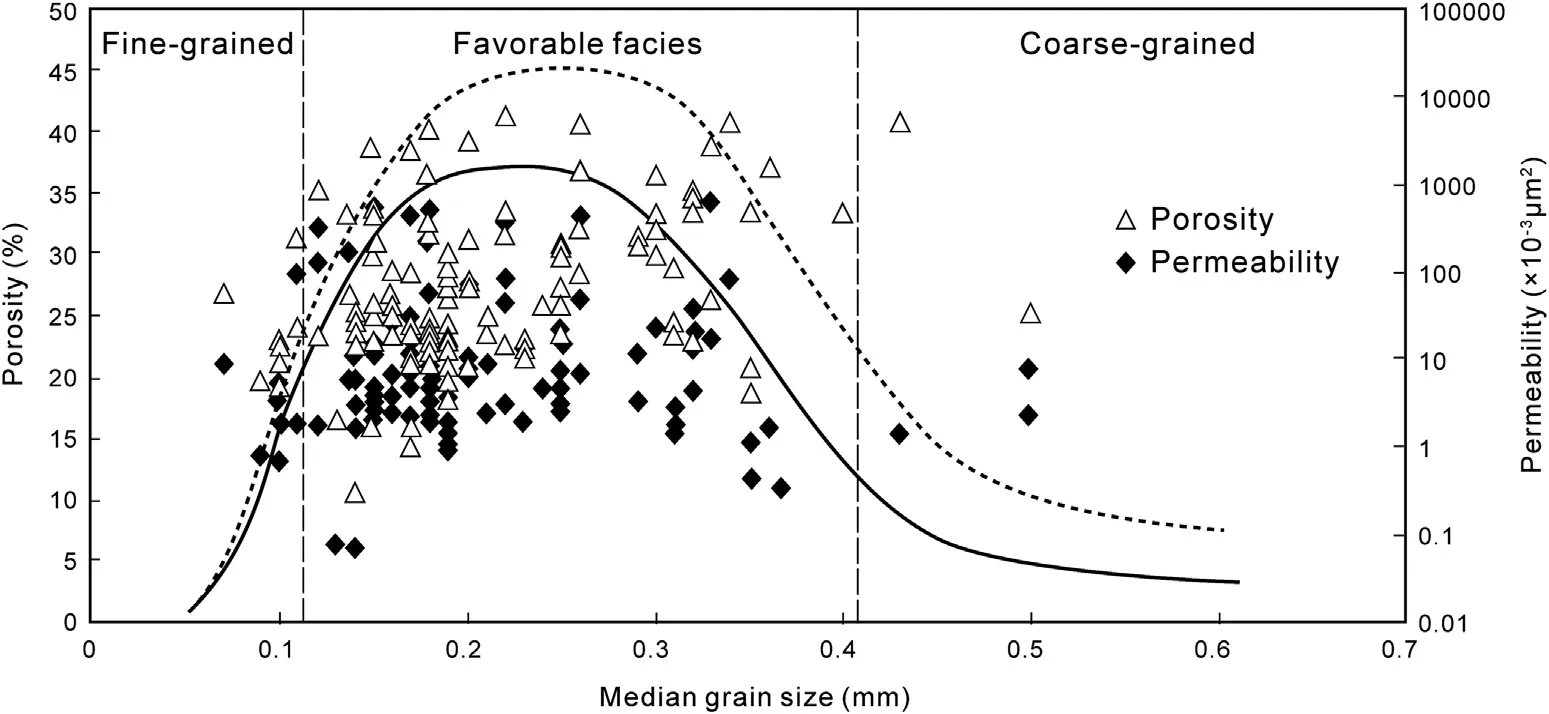
Fig.14-Distribution of the median grain size in Dongying Depression,Bohai Bay Basin.
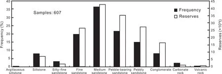
Fig.15-Distribution of the rocks and oil reservoirs and reserves discovered in western Liaohe Depression,Bohai Bay Basin.
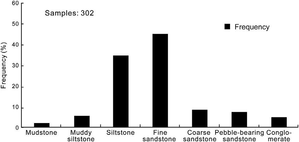
Fig.16-Distribution of the rocks and oil reservoirs and reserves discovered in Tarim Basin.
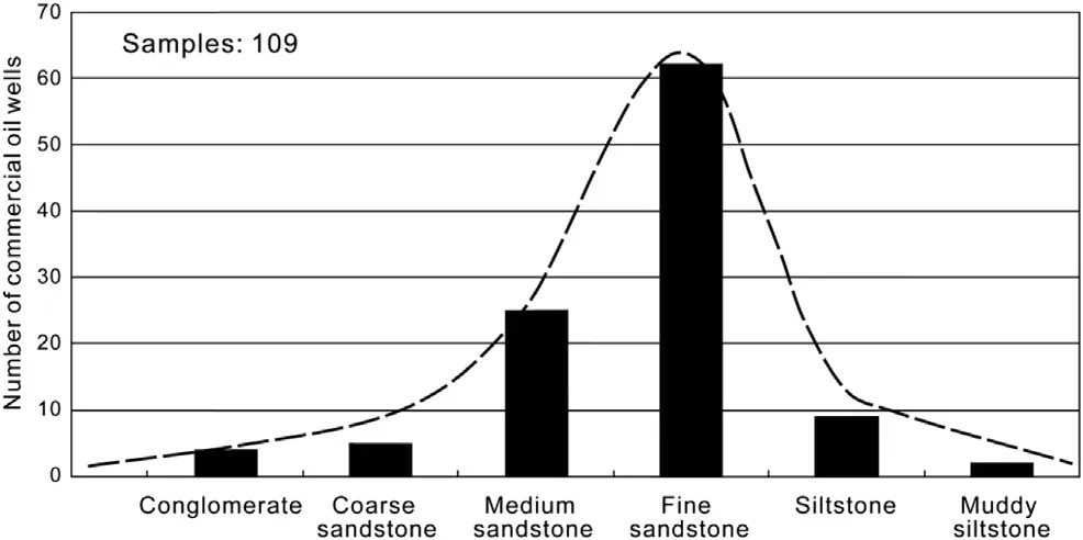
Fig.17-Distribution of rock types and oil wells discovered in the Jurassic,Junggar Basin.
3.2.Relatively high porosity and permeability controlling the hydrocarbon accumulation mechanism
3.2.1.Differences in capillary forces as the most common motive force for hydrocarbon migration in underground media
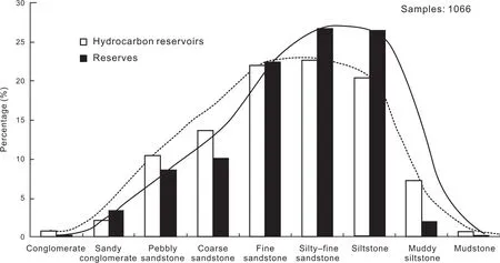
Fig.18-Distribution of rock types,hydrocarbon reservoirs and reserves discovered in Bohai Bay Basin,Tarim Basin,and Junggar Basin.

Fig.19-Sorting degree in the hydrocarbon reservoirs in Bohai Bay Basin,Tarim Basin,and Junggar Basin.
The most common motive force of hydrocarbon migration in porous media filled with pore water is the difference in capillary forces.This force exists in all underground heterogeneous strata.The capillary force itself is the resistance force for hydrocarbon migration;a smaller pore throat radius is associated with greater resistance to hydrocarbon migration.However,with different sizes in wet heterogeneous media,the difference in capillary forces is the motive force for hydrocarbon migration(Mackenzie and Quigley,1988;Stainforth and Reinders,1990;Chen et al.,1995;Pang et al.,2002,2011,2012;Zhao et al.,2007b).The direction of the capillary force difference is dif ficult to ascertain,and its impact on hydrocarbon migration is largely unknown.Therefore,in this study,we define the capillary force acting on the unit area as the interfacial potential energy,and then use this value to characterize the effect of capillary force.
The quantitative expression of the interfacial potential energy in rock is given as follows:

Where Φris the fluid potential(in J);σ is the interfacial force(in N/m);θ is the contact angle in multiphase fluid(in°);D is the particle radius of sandstone(in μm),and z are the burial depths of sandstone(in m).
3.2.2.Significance of low-potential areas for the accumulation and long-term preservation of underground hydrocarbon
Low-potential areas are beneficial for the accumulation and preservation of hydrocarbon.It has been determined that the pore throat radius is significantly larger and capillary force is accordingly weaker in low-potential areas.In comparison with surrounding high-potential areas,low-potential regions exhibit capillary reduction and show evidence of capillary differences(Fig.25).In isolated turbidite sandstone bodies surrounded by mudstone,the driving force(F)is the difference between the capillary force in mudstone(Pcn)and that in sandstone(Pcs).The resisting force(f)of the hydrocarbon migration in the sandstone is the capillary force inside the sandstone.The driving force(F)and the resisting force(f)can be quantitatively calculated using Equations(2)and(3)below.Because hydrocarbon has different interfacial forces(σ)and contact angles(θ),their driving forces and resisting forces differ.However,when hydrocarbon enterslowpotential areas,both show a dynamic balance and thus are in a stable state.If the surrounding conditions do not change,the hydrocarbon can be preserved for lengthy periods.However,if tectonic deformation occurs or if the surrounding temperature and pressure change,the hydrocarbons may continue to migrate into new low-potential areas to form new accumulation.
The driving force of the accumulation can be expressed as

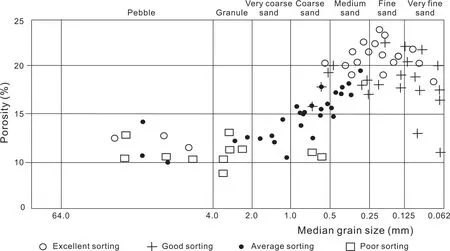
Fig.20-Sorting degree,size,porosity and their correlation(modified from Sneider et al.,1977).
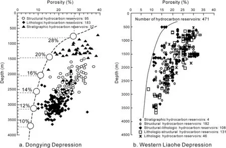
Fig.21-Decrease of the critical properties of effective reservoirs with increasing depth in the Bohai Bay Basin.
The resisting force the of accumulation can be expressed as

And the basic conditions of the accumulation can be expressed as
where F is the driving force of hydrocarbon entering the sandstone;Pcn is the capillary of the surrounding mudstone;Pcs is the capillary of the sandstone reservoir;r is the porethroat radius of the surrounding mudstone;R is the porethroat radius of the sandstone;θ is the contact angle;σ is the fluid interfacial force;H is the burial depth of sandstone;Φn is the interfacial potential of the mudstone out of the trap;and Φs is the interfacial potential of the sandstone in the trap.
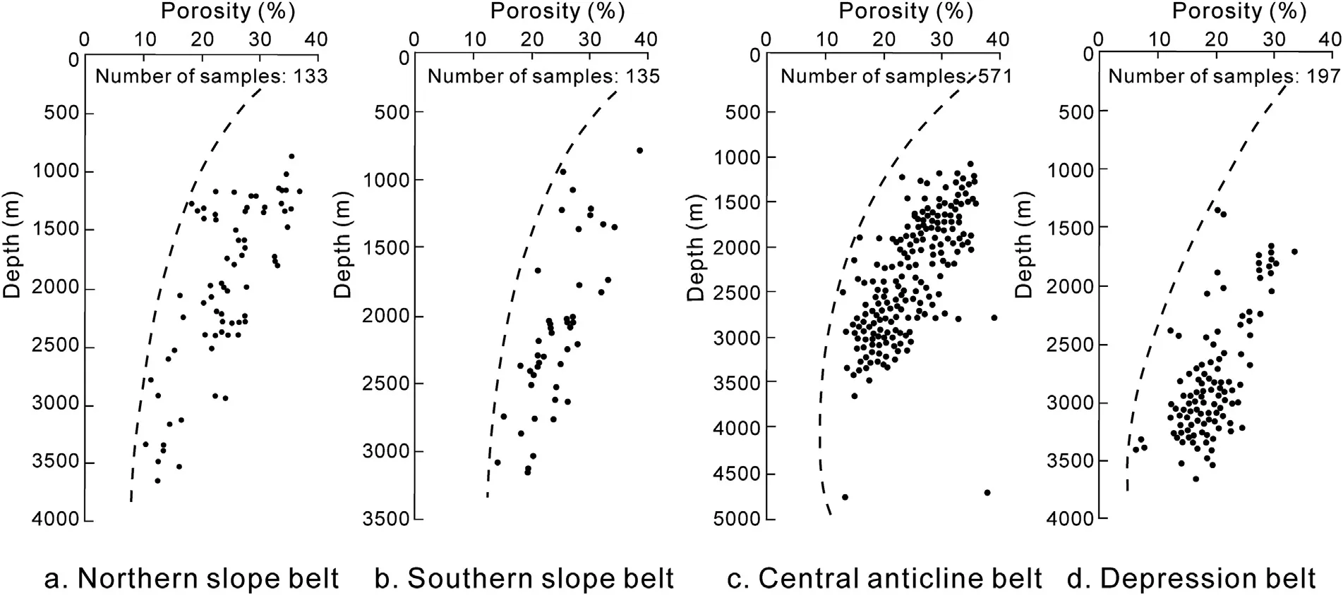
Fig.22-Change of critical properties of the effective reservoirs in different structural units in Dongying Depression,Bohai Bay Basin.
Fig.23-Change of the critical properties of effective reservoir in different sedimentary facies in Dongying Depression,Bohai Bay Basin.
3.2.3.The critical condition of hydrocarbon accumulation in a trap
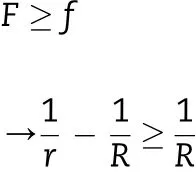
The precondition of hydrocarbon migration is that the driving force(F)is higher than the resisting force(f).According to this theory,the correlated conditions are plugged into Equations(2)and(3),and the final results of the equation F≥f are derived in Equation(4).This result indicates that the critical precondition for hydrocarbon entering a sandstone body is that the interfacial potential(Φn)in the surrounding rock must be more than twice of that in the reservoir(Φs).Such conditions exactly coincide with the statistical results of more than 24,000 hydrocarbon accumulations in Jiyang Depression in Bohai Bay Basin.When the in fluence of burial depth is not considered,results coincide exactly for hydrocarbon accumulations that are buried less than 500-m deep.However,with increasing burial depth,the resisting force of hydrocarbon entering into the trap also increases.Accordingly,accumulation requires a greater driving force or higher potential difference,which can be 3,5,10,or even 20 times higher when burial depths reach 1000 m,2000 m,3000 m,and 4000 m(Fig.26).
3.2.4.Increase of dif ficulty for hydrocarbon accumulation in traps with increasing depth
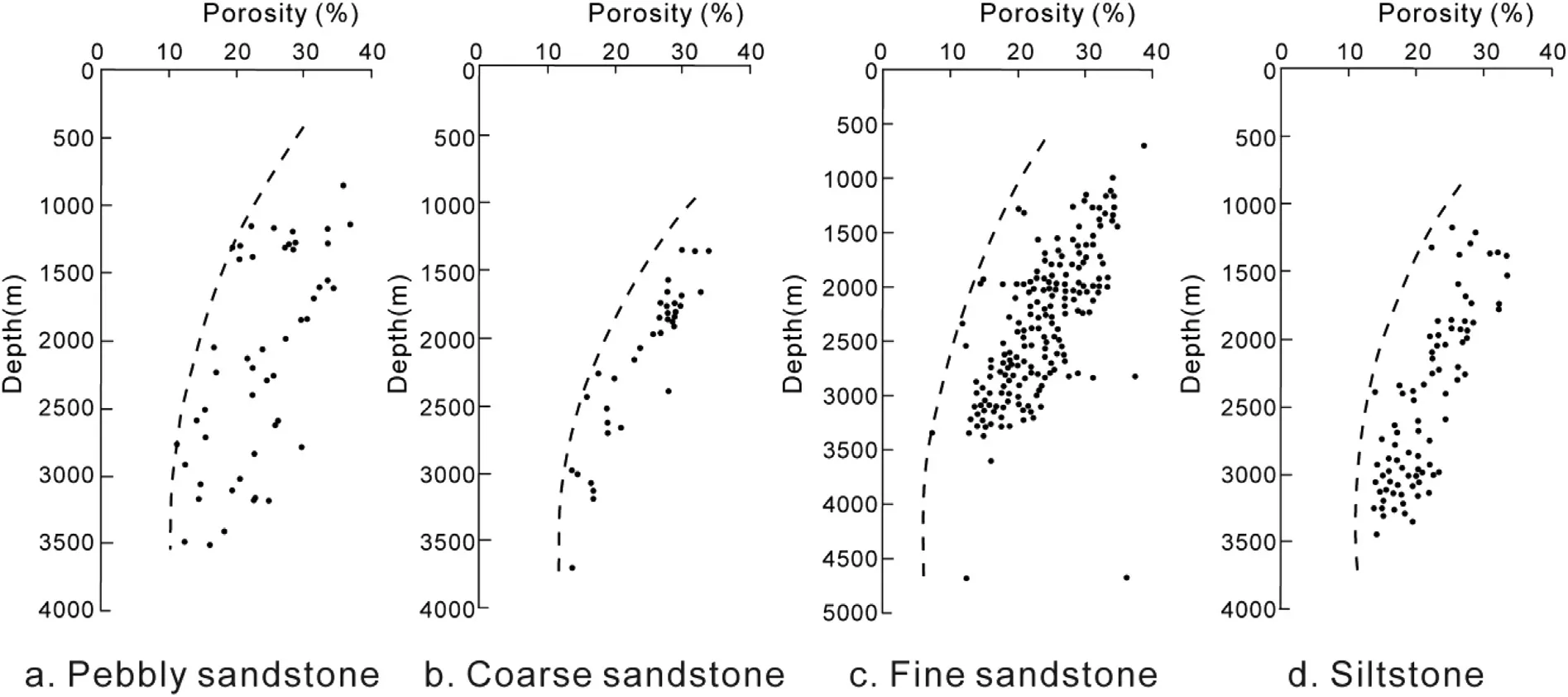
Fig.24-ChangeofthecriticalpropertiesofeffectivereservoirindifferentrocktypesinDongyingDepression,BohaiBayBasin.
As burial depth increases,it becomes more dif ficult for hydrocarbon to enter traps.The porosity of the reservoir in the trap decreases with burial depth,leading to an increase in interfacial potential and the capillary force required to overcome it.Moreover,the hydrostatic pressure of fluids increases with burial depth,leading to an increase in the resisting force required for expelling the pore water from the trap.In this situation,the critical condition for hydrocarbon entering the trap changes.Research into this study showed that the minimum resistance is in direct proportion to the hydrostatic pressure and capillary force in the sandstone body.The relationship of these factors is expressed in Equation(5).These dynamic analysis and research results perfectly coincide with the statistical results of more than 24,000 hydrocarbon accumulations in Jiyang Depression in Bohai Bay Basin.Moreover,the critical condition is not fully equal to the sum of the capillary force and hydrostatic pressure in the trap.Our findings indicate the presence of additional forms of effective forces that warrant further research and analysis.

where f is the resisting force against hydrocarbon entering the sandstone;f(H)is the additional resistance hydrocarbons incur when entering into the sand lens,with the exception of the capillary force;r is the pore throat radius in the surrounding mudstone;R is the pore throat radius in the sandstone body;θ is the contact angle;σ is the fluid interfacial force;and H is the burial depth of the sandstone body.

Fig.25-Model of facies with relatively high porosity and permeability.F=The driving force;f=The resisting force.
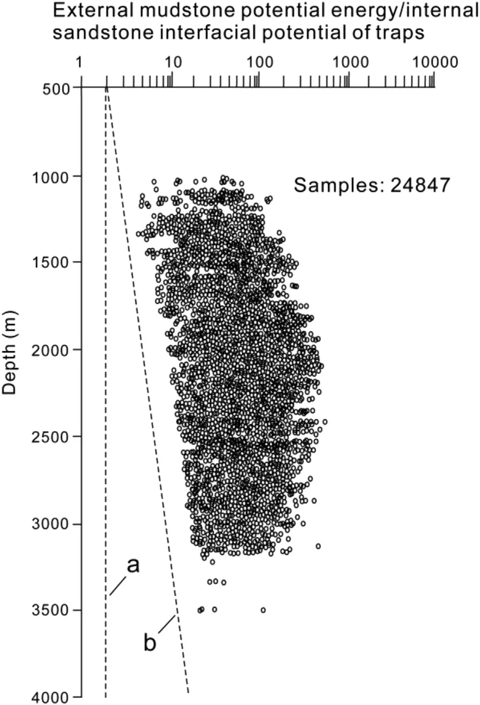
Fig.26-Change of the critical condition of hydrocarbon accumulation with increasing depth.a-The critical condition of hydrocarbon accumulation near the Earth surface;b-Laws of critical condition changing with burial depth,which shows that deeper burial relates to less hydrocarbon accumulation and higher critical conditions.
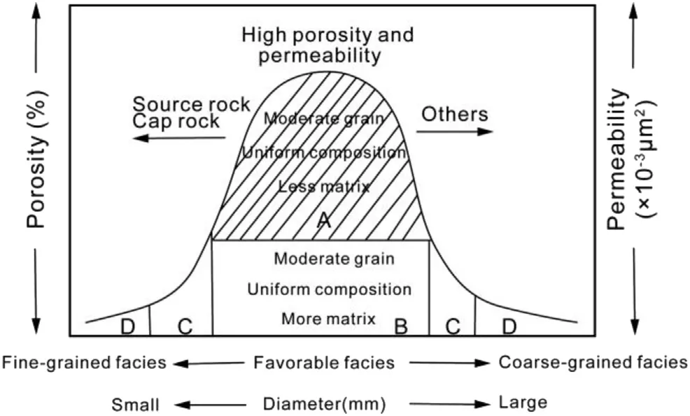
Fig.27-Favorable facies and relatively high porosity and permeability as factors controlling the hydrocarbon accumulation model.
4.Model of hydrocarbon distribution
4.1.Basic controlling factors
Reservoir controlled by favorable facies and relatively high porosity and permeability are the basic patterns of faciescontrolled hydrocarbon accumulation,which contains three geological meanings:
1)Favorable facies is a necessary but not suf ficient condition for hydrocarbon accumulation,that is,the reservoir with favorable facies cannot always control hydrocarbon accumulation anddistribution.Strata with favorablefacies may not be able to form and develop hydrocarbon reservoir under any of the following three conditions:(i)the effective porosity of strata with favorable facies is near zero on account of compaction and diagenesis;(ii)strata with favorable facies are in high potential belts on account of later tectonic deformation;(iii)there is no hydrocarbon source.
2)Relatively high porosity and permeability are necessary conditions for hydrocarbon accumulation in reservoir,but they are not suf ficient,meaning that reservoir with relatively high porosity and permeability cannot always control the hydrocarbon accumulation and distribution.Strata with high porosity and permeability may not be able to form and develop hydrocarbon reservoir under any of the following three conditions:(i)the porosity and permeability of the surrounding strata are higher than the target layer because of dissolution,i.e.,the targetlayer is in a high potential belt(Fig.26);(ii)strata with high porosity and permeability are lower because of tectonic deformation;(iii)there is no hydrocarbon source.
3)Reservoirwith favorable facies and relatively high porosity and permeability can be beneficial to hydrocarbon accumulation.According to the reservoir distribution characteristics found in Bohai Bay Basin,Tarim Basin,and Junggar Basin,the control of favorable facies and relatively high porosity and permeability coupling mode in hydrocarbon accumulation is summarized in Fig.27.This mode can be divided into four areas.Area A is favorable facies with high porosity and permeability controllingthehydrocarbon accumulation.Ithashigh porosity and permeability reservoir with moderately sized grains,uniform composition,and few matrices,which are also beneficial to hydrocarbon accumulation.Area B is the favorable facies with low porosity and permeability controllingthehydrocarbon accumulation.AreaB has moderately sized grains but not uniform composition,a highpercentageofmatrixes,low porosityandlow permeability,which isunbeneficialforhydrocarbon accumulation.Areas C and D are unfavorable facies with low porosity and permeability controlling hydrocarbon accumulation.They have low mineral maturity and poor physical properties because the rock grain size is too big or too small,which works against hydrocarbon accumulation.It should be emphasized that reservoir with porosity less than 10%and permeability less than 1×10⁻³μm2also can accumulate hydrocarbon even when the porosity and permeability are reduced.
4.2.Probability of hydrocarbon reservoirs distribution
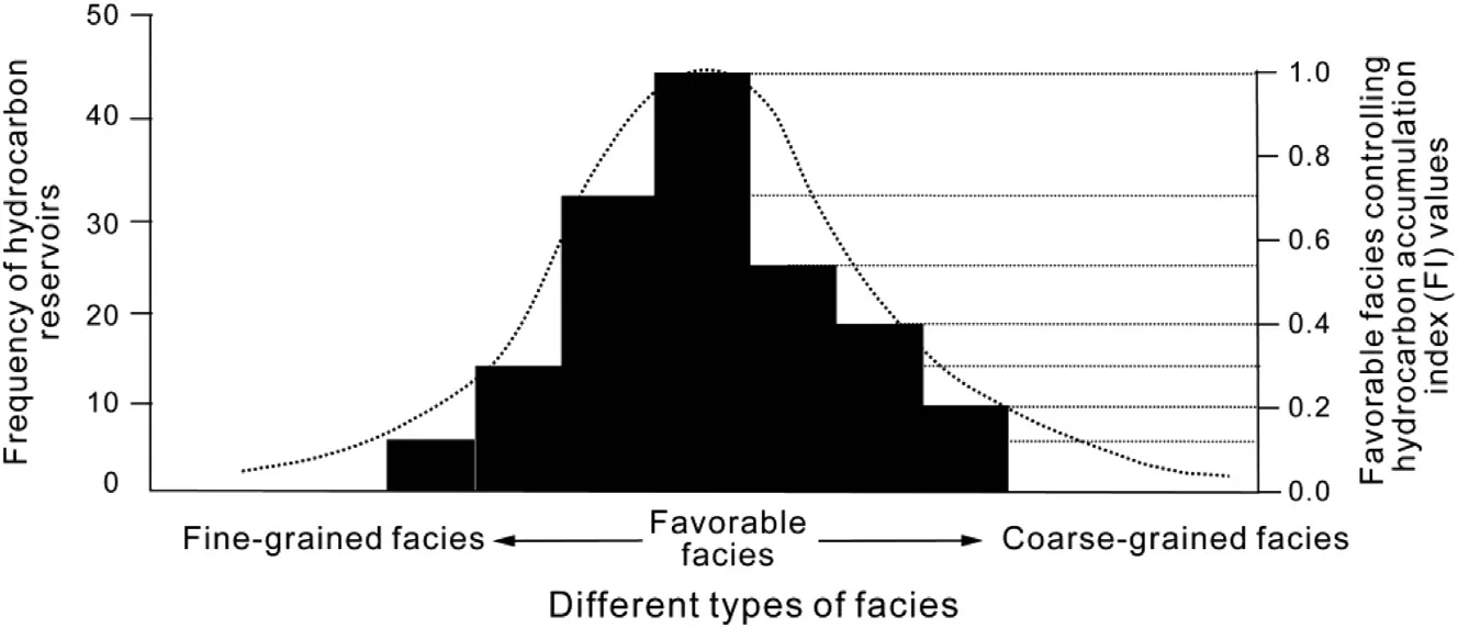
Fig.28-Quantitative characteristics of favorable facies controlling the hydrocarbon accumulation model.
The probability of facies controlling distribution of hydrocarbon reservoirs implies that it is likely that one type of facies is most beneficial for the formation of hydrocarbon reservoir.In practice,the probability of facies controlling distribution of hydrocarbon reservoirs is quantified by a method in which various facies are given different numerical values during the various exploration stages.Sedimentary facies is studied during the early-to-mid exploration stage of the petroliferous basin.The lithology characters,porosity and permeability are studied during the later stages of exploration or hydrocarbon reservoirs development(Fig.28).
As stated above,in practice,the probability of faciescontrolled distribution of hydrocarbon reservoirs is quantified by assigning different numerical values to different sedimentary facies.The quantitative standard between facies and the probability of hydrocarbon accumulation has been established by counting the numbers of discovered hydrocarbon reservoirs(reserves)in different facies.In a given target layer,the facies containing the maximum number of hydrocarbon reservoirs can be given the value of 1,and the facies without any oil and gas reservoirs can be given the value of 0.The others are given values representing the probability of facies-controlled hydrocarbon accumulation according to their geological features and their porosity and permeability features combined with the numbers of discovered hydrocarbon reservoirs or reserves(Fig.28).As shown in the figure,the probability of hydrocarbon reservoirs decreases when the hydrodynamic force is too high or too low and also in cases of the rocks with too coarse or too fine grains.
5.Conclusions
1)The controlling effects of sedimentary facies are expressed by obvious differences in the hydrocarbon-containing features of different sedimentary facies.The controlling effects of lithologic characters are such that hydrocarbon reservoirs are mainly distributed in silty- fine sandstone and fine sandstone,and clastic rocks with too coarse and too fine grains work against hydrocarbon accumulation.The basic reasons are that the relative porosity and permeability of reservoir are low,leading to the low capillary force differences or interfacial potential with surrounding rocks and insuf ficiency of dynamic force for hydrocarbon accumulation.The critical condition for hydrocarbon entering reservoir is that the interfacial potential(Φn)in the surrounding rock must be more than twice of that in the reservoir(Φs).
2)Reservoir control with favorable facies and relatively high porosity and permeability is the basic control pattern of facies-controlled hydrocarbon accumulation.The probability of hydrocarbon reservoirs distribution decreases in cases where the hydrodynamic force is too high or too low and when the rocks have too coarse or too fine grains.
Acknowledgements
This work was supported by the National Basic Research Program of China(Grant No:2011CB201100)and China NationalNaturalScienceFoundation Program (GrantNo.41402107).We thank the Shengli Petroleum Bureau,SINOPEC,Exploration and Development Research Institute of the Tarim Oil field Company and Karamay Oil field Research Institute of the Xinjiang Oil field Company,PetroChina,for providing background geologic data and permission to publish the results.
杂志排行

Journal of Palaeogeography的其它文章
- Calcareous nannoplankton dating of the Late Quaternary deposits in Greece and the eastern Mediterranean:Case studies from terrestrial and marine sites
- Correction of two Upper Paleozoic stratigraphic units in the Tianshan Mountains region,Xinjiang Uygur Autonomous Region and implications on the Late Paleozoic evolution of Tianshan tectonic complex,Northwest China
- End-Triassic nonmarine biotic events
- Correction of two Upper Paleozoic stratigraphic units in the Tianshan Mountains region, Xinjiang Uygur Autonomous Region and implications on the Late Paleozoic evolution of Tianshan tectonic complex,Northwest China
- Modeling the Middle Jurassic ocean circulation
- Lithofacies palaeogeography of the Carboniferous and Permian in the Qinshui Basin, Shanxi Province, China