Correction of two Upper Paleozoic stratigraphic units in the Tianshan Mountains region, Xinjiang Uygur Autonomous Region and implications on the Late Paleozoic evolution of Tianshan tectonic complex,Northwest China
2015-03-21ZhongQiangChenZhuoTingLiaoLuJunLiu
Zhong-Qiang Chen *, Zhuo-Ting Liao, Lu-Jun Liu
a State Key Laboratory of Biogeology and Environmental Geology, China University of Geo‑sciences (Wuhan), Wuhan 430074, China
b Nanjing Institute of Geology and Palaeontology, Chinese Academy of Sciences, Nanjing
210008, China
1 Introduction
Central Asia is one of the last relatively unstudied/unresolved, and potentially the most exciting, tectonic collages on Earth. This region comprises some 13 tectonically independent blocks/ terranes (Coleman, 1989). Several important tectonic terranes and complexes such as the Tarim Basin, Altaid Mountains, Qaidam Basin, Tianshan Mountains,Junggar Basin, and Kunlun Mountains are situated at Northwest China. During the Late Paleozoic this region comprised a complex mosaic of continental fragments, island arcs, and ocean basins, scattered across the Palaeo-Tethyan ocean and tectonically similar in many respects to Southeast Asia today (Carrollet al., 1990; Windleyet al., 1990, 2007). Of these, the Tianshan Mountains record the collisional history of the Tarim and Kazakhstan palaeo-plates (Allenet al.,1993; Gaoet al., 1998; Windleyet al., 2007; Zhouet al.,2002). The eastward growth of the Kazakhstan Plate was conspicuous during the Paleozoic (Heinhorstet al., 2000),when many Central Asian blocks (such as the Yili Terrane and Tarim Plate) had accreted to this palaeo-plate (Chenet al., 1999; Windleyet al., 2007; Xiaoet al., 2008; Zhouet al., 2002). On the one hand, the Tianshan tectonic complex(TTC) remains one of the last frontiers in geologists’ endeavour for unravelling the complex geological history and geodynamics of Central Asia in relation to the tectonic evolution of the closure of the Tianshan Ocean and consolidation of the Tarim and Yili palaeo-plates. On the other hand,the TTC and its neighbouring sedimentary basins are of enormous economic potential as they host numerous metalliferous deposits and hydrocarbon resources in the Tarim,Turpan and Junggar Basins, Northwest China. Accordingly,studies of these northwestern Chinese tectonic complexes and sedimentary basins have enjoyed a surge in scientific interest over the past 30 years that shows no sign of abating(Allenet al., 1993; Chen and Shi, 2003a, 2003b; Coleman,1989; Gaoet al., 1998, 2009; Heet al., 1994; Liet al.,1989, 2010; Shuet al., 2013; Suet al., 2006a, 2006b, 2010;Wanget al., 1994; Windleyet al., 1990, 2007; Xiaoet al.,1992, 2008; Zhang and Zhai, 1993).
Many new geochemical approaches and isotopic dating analytical techniques have greatly advanced tectonic studies of the TTC and facilitated the proposal of many new tectonic models (Xiaoet al., 2008; and references therein).However, geological models for the sedimentary history and tectonic evolution of this tectonically complicated region are still, at the best, controversial due to lack of sound tectonostratigraphic studies constraining plate tectonic/geophysical models. Tectonostratigraphic successions and patterns based on sound palaeontology and palaeobiogeography have been far less studied in comparison with the growing number of geochemical studies of this tectonic complex. In contrast, growing evidence shows that palaeobiogeography is very powerful in determining various tectonostratigraphic provinces and interpretation of tectonic models (Chen, 2004). Here, we document two outstanding examples that explained incorrectly tectonic evolution and models in the Aiweiergou and Bayingou areas, eastern and middle Tianshan Mountains, respectively in Xinjiang Uygur Autonomous Region, Northwest China (see below) due to lack of sound palaeontological and palaeobiogeographic data.
2 Carboniferous tectonostratigraphic successions of the Bayingou area, eastern Tianshan Mountains and regional correlations
The Bayingou (BYG) area is situated at the northern end of the Dushanzi-Kuqa (DK) highway across the Tianshan Mountains, Xinjiang Uygur Autonomous Region, Northwest China (Fig. 1). This area is of high geological importance due to the presence of the Late Paleozoic ophiolite mélange, which has been believed to have formed in the Carboniferous or the Late Devonian-Early Carboniferous interval (Wanget al., 1994, 1997; Xiaoet al., 1992;Zhang and Wu, 1985). The BYG area is generally assigned to the Yilianhabierzha tectonostratigraphic district of the Junggar-North Tianshan tectonostratigraphic Province (Heet al., 1994; Liet al., 1989; Wanget al., 1990, 1994, 1997;Xiaoet al., 1992; Zhang and Wu, 1985). However, most tectonic models on the BYG ophiolite complex lack solid tectonostratigraphic and palaeobiogeographic evidence.In BYG, the Late Paleozoic succession comprises the Anjihai, Shadawang, Bayingou and Keguqingshan Formations in ascending order (Wanget al., 1994, 1997). Of these, the Anjihai Formation yields some important fossils. The Anjihai fossil assemblages therefore are critical in interpreting palaeobiogeographic provincialism, and thus crucial in understanding of tectonic models of the TTC.
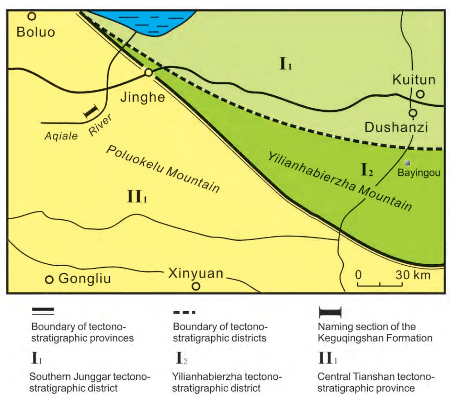
Figure 1 Sketch map showing the Paleozoic stratigraphic provincialism of the eastern-middle Tianshan Mountains region, Xinjiang,Northwest China (after Wang et al., 1994). Note that the BYG area should be re-assigned to the northern Tianshan-Junggar tectonostratigraphic province after the Late Devonian.
2.1 The Anjihai Formation does not yield the Gigantoproductus fauna
The Anjihai Formation (Wanget al., 1994) represents the basal succession of the Bayingou ophiolite mélange(BYGOM) and is lithologically composed of massive tuffaceous sandstone and siltstone. This formation is distributed in the areas between the southern Louweigou and Haxilegengdaban in the central Tianshan Mountains (Wanget al.,1994). Of particular interest is that the Early Carboniferous brachiopodsGigantoproductussp. andSemiplanussp. are reportedly present in the Anjihai Formation (Wanget al.,1994), although no any description or illustrations are available. The presence of theGigantoproductusfauna in BYG therefore remains uncertain.
Morphologically, bothGigantoproductusandSemiplanusare two of the most distinct genera among the Carboniferous brachiopods and are characteristic of the late Viséan-Serpukhovian brachiopods worldwide (Chen, 2004; Chen and Shi, 2003a, 2003b; Yang, 1990). These two genera are of great palaeobiogeographical importance and are characteristic of the Palaeo-Tethyan Province such as the Tarim and South China blocks (Chen, 2004; Chen and Shi, 2003b; Liao,1995; Yang, 1990). Geographical distribution of these two genera in Xinjiang is also pronounced. They are common in the Early Carboniferous strata in the Aolatao, Hanjizha,Keguqing, and Poluokelu Mountains, southwest of the BYG and adjacent Central-South Tianshan Mountain areas. In contrast, four-decade geological investigation reveals that theGigantoproductusfauna is completely absent in the Yilianhabierzha, Bogeda, Haerlike Mountains and vast regions of the Junggar Basin, all of which are located east or north of the BYG complex. AlthoughGigantoproductuswas reportedly present in the Kupu, Qijiajing and northwestern Wuerhe areas, east of the BYG complex, in the geological mapping report in 1960s, these fossil specimens were misidentified asGigantoproductus, but were better re-assigned to its morphological counterparts such asBalakhonia,LinoproductusandSchuchertellaby later palaeontologists (Chen, 2004;Chen and Shi, 2003b; Liao, 1995; Yang, 1990; Zhanget al.,1983). Later, several geological surveys in Xinjiang also revealed that theGigantoproductusfauna is absent in areas east of the BYG complex (Liet al., 1989, 1990).
To determine if theGigantoproductusfauna occurs in the BYG complex, we have also undertaken a geological survey in the Bayingou-Haxilegandaban areas (Fig. 1)where the Anjihai Formation successions are exposed (Liaoet al., 2011). No brachiopod elements were found in our collections. Instead, some brachiopod species, namelySchuchertella heishantouensis,Orthotetessp.,Crurithyrissp., andAthyrissp., are present in the Haxilegengdaban area. These brachiopod elements, however, are indicative of a Late Devonian age rather than an Early Carboniferous age. No signs show that theGigantoproductusfauna occurs in the BYG complex. This inference is also reinforced by Wanget al.’s (1994) clarification that the possible presence of bothGigantoproductusandSemiplanusin BYG was sourced from the earlier geological survey report and was not confirmed by their investigation. Consequently, we considered that the BYG complex belongs to the North Tianshan-Junggar tectonostratigraphic province (cf. Wanget al., 1994) or the Yilianhabierzha oceanic crustal plate (Xiaoet al., 1992). The Aibihu-Yilianhabierzha-Xinxinxia Fault,the major fault of the TTC, bounded the southern margin of the BYG complex (Xiaoet al., 1992).
2.2 Stratigraphic correlations and palaeobiogeographical implications of the BYG fossil assemblage
Succeeding the Anjihai Formation, the sediments of the Shadawang and Bayingou Formations are distributed along the junction between the Kuitun and Shadawang Rivers and middle and upper cream areas of the Bayingou (Gangou)valley. The Shadawang Formation consists of volcanic lava/basalt, ultrabasic rocks, and radiolarites, yielding the Early Carboniferous radiolarians, while the Bayingou Formation is dominated by black rhymic tuffaceous siltstones of Carboniferous age (Wanget al., 1994). The latter unit was interpreted as a flysch facies succession overlying unconformably on the ophiolites and form the major stratal package of the BYG ophiolite complex together with the Shadawang Formation (Xiaoet al., 1992). The upper part of tectonostratigraphic succession of the BYG complex was assigned to the Keguqingshan Group (Wanget al., 1994) including compositionally complicated conglomerates. Tectonostratigraphic succession of the BYG complex represents the sedimentation in environmental settings varying from remnant oceanic crust, remnant oceanic basin to shallow marine and terrestrial successions, exhibiting dynamic evolution of the formation of the BYG ophiolite complex and subsequent orogenic history (Xiaoet al., 1992). Here, we have different opinions on the nomenclature of the Keguqingshan Group and correlate the stratal package of the BYG complex differently (Fig. 1).
2.2.1 Nomenclature of the Keguqingshan Group
The Keguqingshan Group was established in the Regional Strata Chart of Xinjiang by CGRSCX (1981) based on the succession logged by the No. 13 Team of the Soviet Union Geology Survey downstream along the Aqiale River in the Poluokelushan Mountain, Xinjiang. The lithology is characterized by the compositionally complicated conglomerates,quartz porphyry interbedded with sandstone and shale in the lower part and the sandstones interbedded with limestones and muddy limestone in the upper part. This group is up to 1350 m thick and has been treated as the marker of the topmost marine beds of the Carboniferous due to the presence of fusulinid foraminiferSchwagerina princes,which is younger than the Moscovian (Late Carboniferous)worldwide (Zhu, 1997). Nevertheless, Wu (1991) pointed out thatSchwagerina princeswas misidentified in BYG. The author further clarified that the fusulinid fauna younger than the Moscovian has never been reported from the central Tianshan areas (Wu, 1991). Our investigation also confirms that no fusulinid zones higher than theFusulinaZone are recognized in the central Tianshan areas. After a detailed geological survey along the Aqiale River and logging the Carboniferous section in the Suguersu area, we found that the depositional successions at the type section of the Keguqingshan Group in the down stream area of the Aqiale River include various stratigraphic units ranging from the Upper Devonian to Upper Carboniferous in age. The fossil-bearing strata in Suguersu are better assigned to the Dongtujinghe Group, a stratigraphic unit widely applied to regional geological survey and mineral exploration practices. The highest marine bed is dated by the presence of theFusulinaZone. The Keguqingshan Group therefore should be abandoned due to its poor definition (Wu, 1991). Consequently,it is inappropriate to apply the abandoned “Keguqingshan Group” to accommodate the conglomerate-dominated succession of molasse facies in BYG (Wanget al., 1994).
Regionally, the BYG conglomerate overlies unconformably the slightly metamorphosed carbonates of the Qijiagou and Aoertu Formations in the areas from the mouth of the BYG valley eastwards to the Anning River. Similarly, a massive conglomerate-volcanic package was found to overlie the Aoertu Formation carbonates in both the Taodonggou and Taoxigou sections, north of the Turpan train station,Turpan City, eastern Xinjiang (Fig. 2; Liaoet al., 1987). Liaoet al.(1987) also proposed the Taoxigou Group to accommodate the conglomerate succession, which is characterized by volcanic breccia and tuffaceous breccia within the lower part, terrestrial siliciclastics within the middle part and andersites within the upper part (Fig. 2; Liaoet al.,1999). This group is about 1150 m thick and assignable to the molasse facies, indicating tectonic uplift as the result of the Tianshan orogeny (Liaoet al., 1999; Liao and Liu,2001). The Taoxigou Group is not only well exposed along the southern foot of the Bogeda-Haerlike Mountains, but also extends westerly to the Aiweiergou area of the Yilianhabierzha tectonostratigraphic district.
The Taoxigou Group is widely distributed along the southern foot of the northern Tianshan Mountains from Bayingou,via Aiweiergou eastwards to Taoxigou, Qijiajing and even to Kulai and Erdaogou of the northern Hami area. This group is characterized by compositionally different conglomerates and breccia and was formed as the result of tectonic uplifts during the Carboniferous-Permian orogeny in this region.All lines of evidence indicate that the Taoxigou Group is more suitable than the “Keguqingshan Group” to accommodate the conglomerate-dominated succession exposed in the BYG complex.
2.2.2 Stratigraphic correlation and palaeobiogeographic implication
The ophiolite mélange around the Junggar Basin, northern Xinjiang has long been disputed in terms of regional distributions, generic types, quantity, and formation ages despite of four decade-efforts (Heet al., 1994; Liet al.,1989; Xiaoet al., 1992; Zhang and Zhai, 1993). Little has been published on the correlations among these ophiolite belts in northern Xinjiang. Wanget al.(1994) referred the BYG ophiolite mélange to the Central Tianshan Orogenic Zone and never compared them with the counterparts exposed at the eastern and western margins of the Junggar Basin. However, the BYG complex bears remarkable resemblance with the Dalabute (DLBT) complex of northern Zhayiershan along the northwestern margin of the Junggar Block in terms of tectonostratigraphic successions, faunal assemblages and formation ages. The DLBT complex is the youngest among these complexes (i.e., Tangbale and Hongguleleng complexes) surrounding the Junggar Block (Wuetal., 1993; Zhang and Zhai, 1993). Like the BYG complex,the DLBT complex is also attached to the Junggar Block and records the depositional successions from remnant oceanic crusts, to deep oceanic basin to molasse facies due to oceanic closure and subsequent orogenic uplift. Its tectonostratigraphic succession comprises Tailegula, Baogutu, Xibeikulashi and Chidi Formations in an ascending order. These depositional units resemble superficially the Anjihai, Shadawang, Bayingou and Taoxigou Formations of the BYG complex in terms of mineral compositions, petrographic texture and depositional settings, indicating that both complexes share similar tectonic background and settings when they were deposited. Accordingly, we consider that the BYG complex is closely affiliated with the northern Tianshan-Junggar Block, not the Central Tianshan Complex Belt as suggested previously (Wanget al., 1994).
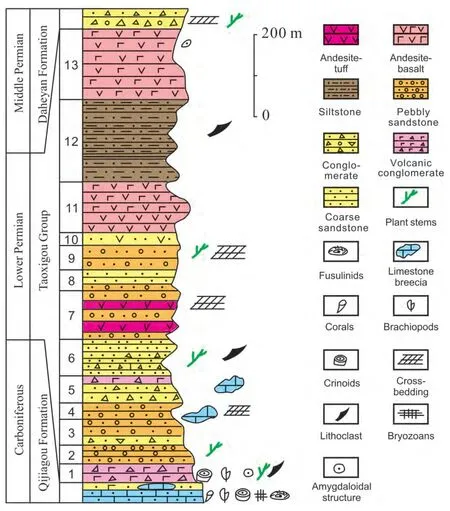
Figure 2 Stratigraphy of the Lower Permian Taoxigou Group at its type section in the Taoxigou valley near the Taoshuyuan train station of Turpan City, eastern Xinjiang.
More importantly, fossil assemblages from both complexes also share high similarity in faunal compositions and age constraints. As mentioned above, we have detected some fossils from various horizons of the BYG complex depositional successions. For example, considerably abundant fossil assemblages were obtained from the junction between the Shadawang River and the DK highway (Fig. 3). It should also be noted that Wanget al.(1994) also mentioned abundant benthic fossil assemblages (mainly brachiopods and corals) from the BYG complex. These authors however did not list the taxonomic names. They therefore are difficult to compare with our collection. However, both taphonomic states and biofacies of the newly obtained fossils are very similar to these reported from the complexes elsewhere in Xinjiang. The fossil hosting strata comprise rhymic tuffaceous siltstones interbedded with carbonate breccia and conglomerates. These limestone breccias, varying in clast sizes from 1-20 cm in diameter, are comprised of muddy limestone and yield abundant fossils. The fossil assemblage is dominated by the shallow-water faunas of crinoids and brachiopods. Brachiopods are abundant and include:Ne‑ospirifer tegulatus(Trautschold),Buxtonia rarirugosa(Licharew),Cancrinella koninckian(Verneuil),Eomarginiferasp.,Linoproductus praelongatusZhang,Linoproductus simenensis(Tschernyschew),Echinoconchus fasciatus(Kutorga),Phricodothyrissp.,Martiniasp.,Dielasmasp., and?Paramuirwoodiasp. Of these, some large brachiopod shells were deposited as independent breccia clasts. In contrast,the matrix rocks are dominated by rhymic siltstone suggestive of a deep-water depositional environment. Accordingly, these benthic faunas inhabited originally shallow-water settings and were later transported to the deep-water settings together with limestone breccia.
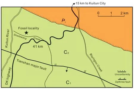
Figure 3 Fossil locality of the Bayingou (BYG) ophiolite mélange near Kuitun City, Xinjiang (after Wang et al., 1994). C1 = Lower Carboniferous; C2 = Upper Carboniferous; P1 = Lower Permian; DK = Dushanzi-Kuqa.
Of the BYG brachiopod fauna, several elements, includingNeospirifer tegulatus,Buxtonia rarirugosa,Cancrinella koninckian,Linoproductus praelongatus,Echinoconchus fasciatus, and ?Paramuirwoodiaare very common in the Bashkirian to Moscovian strata in Xinjiang and elsewhere in Central Asia (Chen, 2004; Chen and Shi, 2001, 2003b;Liao, 1995; Yang, 1964; Zhanget al., 1983). Surprisingly,similar sedimentary packages and faunal assemblages were also detected in the Bagutu and Xibeikulashi Formations of the Zhayiershan of the western Junggar areas. For example, we have also found the reworked limestone breccia bearing benthic fossils, which are interbedded within the rhymic siltstone-dominated flysch facies succession at the Liudonggou section near Liushugou and the type section of the Xibeikulashi Formation near the Xibeikulashi area of Tuoli County (Liaoet al., 1990a). The Tuoli fossil assemblage is also dominated by shallow-water benthic faunas of crinoids and brachiopods. Of these, brachiopods are similar to those of the BYG complex. Both of them are characteristic of the early Late Carboniferous faunas of the Junggar-Xingan Province (Liao, 1995; Yang, 1990). In contrast, the matrix sediments of both the Bagutu and Xibeikulashi Formations, together with the underlying Tailegula Formation,are generally believed to represent deep-water turbidites(Jing, 1989; Liaoet al., 1993; Wuet al., 1993). Accordingly, these shallow-water brachiopod and crinoid fossils were transported from shallow habitats and deposited in deep-water settings. All lines of evidence show that the BYG complex resembles remarkably the DLBT complex in tectonostratigraphic successions and faunal assemblages.Both complexes represent the youngest orogenic suture belts around the margins of the Junggar remnant oceans during the early Late Carboniferous. Therefore, the BYG complex has been likely part of the northern Tianshan-Junggar Block since the Late Devonian, although it may be part of the Central Tianshan tectonostratigraphic province prior to the Late Devonian (Wanget al., 1994).
3 Permian-Triassic tectonostratigraphic successions of the Aiweiergou area and implications for tectonic interpretation of the Tianshan complex
The Aiweiergou (AWEG) is located about 120 km south of the Urumqi City, capital of Xinjiang Uygur Autonomous Region, northwest China (Fig. 4). AWEG is well-known for the coal mine, which has been operated since the 1950s. In this area, the Permian, Triassic and Jurassic strata are well exposed with coal measures occurring in the Jurassic succession. The Permian and Triassic successions are separated by a regional unconformity along the entire southern margin of the Junggar Basin. This unconformity is marked by the coarse conglomerate of the Karamay Formation overlying on various units of Middle-Late Permian age. More recently, an influential study addressing on the Central Asian tectonic evolution (Xiaoet al., 2008) has drawn our attention.In that study, Xiaoet al.(2008, p. 108,op.cit.Fig. 4) interpreted the Upper Permian clastics exposed near the 106 km milestone marker of the Urumqi-AWEG (UA) highway as deep-water turbidites. These authors have also interpreted the unconformity between the Upper Permian clastics and the overlying Karamay Formation of the Middle-Late Triassic age as the evidence of closure of Tianshan Ocean and subsequent consolidation between the Tarim Block and the accreted Siberian-Junggar palaeo-Plate. As such, Xiaoet al.(2008) inferred that the Tarim Block was accreted to the accreted Siberian Craton during the latest Permian to Triassic. Here, we interpret differently the Permian sedimentary settings of this area and their tectonic implications.
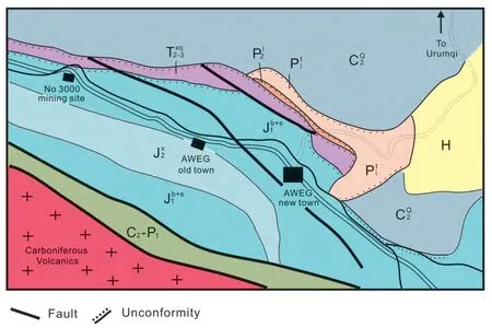
Figure 4 Geological map of the Aiweiergou (AWEG) area, South Urumqi, Xinjiang. C2Q = Upper Carboniferous Qijiagou Formation;C2-P1 = Upper Carboniferous-Lower Permian rocks; P1t = Lower Permian Taerlong Formation; P2l = Middle Permian Lucaogou Formation;T2-3xq = Middle-Upper Triassic Xiaoquangou Group; J1b+s = Lower Jurassic Badaowan and Sangonghe Formations; J2x = Middle Jurassic Xishanyao Formation; H = Holocene rocks.
3.1 Permian-Triassic stratigraphy in AWEG
Geological surveys in AWEG have been conducted to search for coal resources since the 1950s. The Northwest Petroleum Exploration Bureau assigned the Permian and Triassic sediments to the Yaomoshan and Xiaoquangou Groups for the first time, respectively in the mid-1950s. The former unit represents the Upper Permian succession, while the Xiaoquangou Group includes the Middle-Late Triassic successions. This stratigraphic subdivision has been followed by later studies (i.e., CGRSCX, 1981). However, Zhang and Wu(1991) correlated the Permian and Triassic successions of AWEG with these exposed in the northern Taoshuyuan area of Turpan City and applied the Taodonggou Group (including the Daheyan and Taerlong Formations) to include the lower part of the Upper Permian succession, the Xiachangfenggou Group (Quanzijie and Wutonggou Formations) for the upper part of the Upper Permian succession, and the Xiaoquangou Group for the Middle-Upper Triassic sediments.
In AWEG, the lower part of the Permian succession is characterized by volcanics, volcanic conglomerates and coarse terrestrial clastics (Fig. 5), which were previously assigned to the Daheyan Formation of the Taodonggou Group (CGRSCX, 1981). However, these rocks are very different from the lithology of the typical Daheyan Formation,which is characterized by fluvial facies consisting of coarse sandstone and conglomeratic sandstone. In contrast, the AWEG depositional package is indicative of a molasse facies succession and assignable to the Taoxigou Formation of the Turpan area, eastern Xinjiang (Fig. 2). Here, both macrofloral and microfloral assemblages derived from the upper part of the Taoxigou Group suggest an Asselian-Sakmarian(Early Permian) age for the unit (Liaoet al., 1999).
Overlying the Taoxigou Group, a thick succession of black shale was deposited and they were previously ascribed to the Taerlong Formation (Huet al., 1991; Zhang and Wu,1991). This succession is lithologically distinguished from that of the Taerlong Formation at its type section of the Taoshuyuan area, but is similar to those of the contemporaneous Lucaogou Formation exposed at the northern foot of the Bogda Mountains. These rocks were therefore reassigned to the Lucaogou Formation (Liao and Liu, 2001;Liaoet al., 1999). The Lucaogou Formation yields abundant conchostracans, ostracods, bivalves, gastropods, fishes,plants, and microflora of early Roadian (Middle Permian)age (Liao and Liu, 2001; Ouyanget al., 2003). Changes of stratigraphic subdivision of the Permian and Triassic successions at AWEG are listed on Table 1.
The Lower Triassic is absent in AWEG. The Middle-Late Triassic Xiaoquangou Group includes the Karamay, Huangshanjie and Haojiagou Formations. Abundant conchostracans, bivalves, ostracods, gastropods, insects, and plants have been obtained from the middle-upper Karamay Formation, and Huangshanjie and Haojiagou Formations, and constrain the Karamay Formation as middle-late Triassic in age and both Huangshanjie and Haojiagou Formations as Late Triassic in age (Table 1; Liao and Liu, 2001).
Accordingly, the “Upper Permian turbidite” exposed in AWEG described by Xiaoet al.(2008) should be the alternating shale and sandstone of the early Middle Permian Lucaogou Formation (Fig. 6), while the Late Triassic conglomerate and sandstone should be the Middle-Late Triassic Karamay Formation (Table 1). It should also be noted that age constraints of stratigraphic units described at Stops 7-1 to 7-5 and illustrated by Wanget al.(2010, p. 263,
Fig. 13A, 13B) are incorrect. Of these, the conglomerates illustrated by Wanget al.(2010,op.cit.Fig. 13A) should be Early Permian in age, not Late Carboniferous as noted by Wanget al.(2010,op.cit.Fig. 13A). These rocks should be assigned to the Taoxigou Group (Table 1). Their Figure 13B (Wanget al., 2010) shows the Middle-Late Triassic terrestrial rocks overlying unconformably the early Middle Permian lake-facies succession.
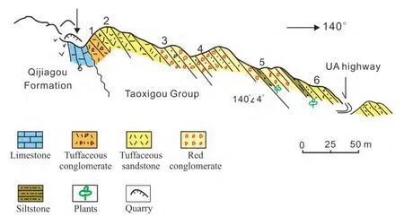
Figure 5 The Taoxigou Group molasse-type succession exposed near the 85 km milestone along the Urumqi-Aiweiergou (UA) highway in the AWEG area.
3.2 Depositional environment of the Middle Permian succession in AWEG
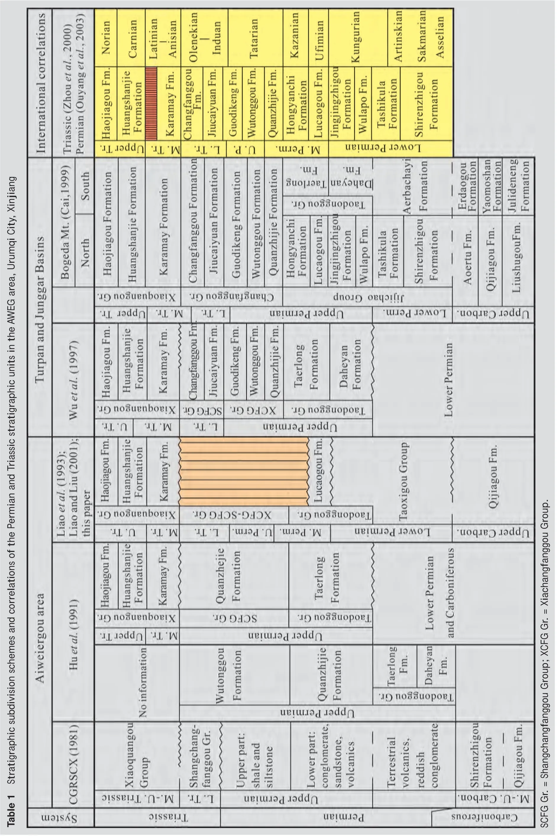
Table 1 Stratigraphic subdivision schemes and correlations of the Permian and Triassic stratigraphic units in the AWEG area, Urumqi City, Xinjiang SCFG Gr. = Shangchangfanggou Group; XCFG Gr. = Xiachangfanggou Group.
In AWEG, the Lucaogou Formation is a black shale-dominated succession with minor interbeds of thin-bedded siltstone, muddy limestone and dolomitic limestone (Hou,2000). Abundant conchostracans, ostracods, bivalves, gastropods, fishes, plants, and microflora (Hou, 2000; Suet al., 2006b,op.cit.Fig. 3 and pl. 1) are typical of the terrestrial assemblage (Liao and Liu, 2001). The black shales of the Lucaogou Formation are very thin, paper-like in sharp contrast to the overlying reddish conglomerate-dominated Karamay Formation in the field. The unconformity between these two units therefore is very conspicuous at the No. 106 km milestone marker (previously, 94 km milestone in the 1990s) of the UA highway (Fig. 6), as illustrated by Xiaoet al.(2008,op.cit.Fig. 4) and Wanget al.(2010,op.cit.Fig. 13B). As such, the so-called Upper Permian“turbidite” deposits actually belong to the lacustrine facies succession of early Middle Permian age. In fact, there are no Permian and Triassic marine sediments present in AWEG where the Permian and Triassic successions represent fluvial to lake facies sedimentation (Hou, 2000; Suet al.,2006a).
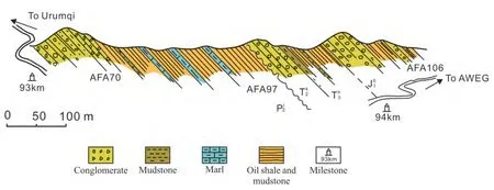
Figure 6 Permian-Triassic successions exposed between 93 km and 94 km milestones along the Urumqi-Aiweiergou (UA) highway in the AWEG area. Note that an unconformity is pronounced between the early Middle Permian Lucaogou Formation and the Middle-Late Triassic conglomerate of the Karamay Formation. P2l = Middle Permian Lucaogou Formation; T2k = Middle Triassic Karamay Formation; T3h = Upper Triassic Huangshanjie Formation; J1b = Lower Jurassic Badaowan Formation.
3.3 Permian-Triassic unconformity in AWEG and its regional tectonic implications
The unconformity beneath the Karamay Formation is not only pronounced in AWEG (i.e., at the site near the No. 106 km milestone marker of UA highway; see Xiaoet al., 2008,op.cit.Fig. 4), but also is well exposed along the entire southern margin areas of the Junggar Basin (CGRSCX, 1981;Zhang and Wu, 1991). At the coal mining site within the western AWEG, this unconformity is defined by the Karamay Formation overlying the Lower Permian volcanics and clastics of the Taoxigou Group or the carbonates of the Carboniferous Qijiagou Formation (Fig. 7). This unconformity is characterized by the Late Triassic Huangshanjie Formation overlying the Carboniferous volcanics eastwards to Keerjian coal mines and western Hongshanzui area. Therein the Karamay Formation is absent. In the Turpan-Hami Basin, east of the AWEG, the conglomerates of the Karamay Formation unconformably overlie the Lower Triassic Changfanggou Formation in the Taodonggou, Kekeya and Zhaobishan areas (CGRSCX, 1981; Liaoet al., 1987, 1998; Thomaset al.,2011; Yanget al., 2007, 2010; Zhang and Wu, 1991; Zhouet al., 2000). Similarly, the Karamay Formation overlies unconformably the Lower Triassic terrestrial strata or even older non-marine (or marine) strata in many areas of the southern margins of the Junggar Basin (CGRSCX, 1981; Huet al., 1991; Liaoet al., 1987, 1998; Ouyanget al., 2003;Wuet al., 1997a; Zhang and Wu, 1991; Zhouet al., 2000).Clearly, the unconformity between the Permian black rocks and Triassic reddish strata seen in AWEG (Xiaoet al., 2008,op.cit.Fig. 4) represents a tectonic uplift event which took place in terrestrial basins of the accreted Junggar blocks during the late Early Triassic to early Middle Triassic times.Prior to the formation of the unconformity, a thick succession of molasse to fluvial to lacustrine facies was deposited during the Early Permian to Early Triassic. This uplift event is therefore much younger than the orogenic uplift events of the Tianshan orogeny indicated by the Early Permian molasse-type sediments (see below).
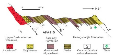
Figure 7 Triassic succession exposed in the No. 3000 mining site of the Aiweiergou area showing the Triassic rocks unconformably overlying the Upper Carboniferous volcanic rocks. T2k = Middle Triassic Karamay Formation; T3h = Upper Triassic Huangshanjie Formation.
3.4 Taoxigou Group and its regional tectonic implications
Previously, Huanget al.(1990) inferred that the closure of the north Tianshan Ocean started in late Middle Carboniferous. The molasse facies sediments were deposited in the orogenic belt during the Late Carboniferous, while the north Tianshan ophiolite mélange is the last suture zone between the Siberian and Tarim plates and consolidation between these two plates took place in the end of the Carboniferous (Huanget al., 1990). Xiaoet al.(1992) considered that north Tianshan and south Tianshan remnant oceanic basins were closed during the Late Carboniferous to early Early Permian times. At the same time, these Paleozoic individual continental blocks consolidated together to form a complete continental block (Xiaoet al., 1992).Similarly, Chenet al.(1993) constrained the closure time of the north Tianshan and western Kunlun oceanic basins as the Early Permian with coeval terrestrial acidic volcanism widespread over the Tianshan region. Maet al.(1993) inferred that the north Tianshan oceanic basins including the Yilianhabierzha-Bogda-Haerlike Mountains were closed during the Late Carboniferous. Heet al.(1995) considered that the Yilianhabierzha area uplifted to a terrestrial setting during the Permian. Liet al.(2006) believed that the Tianshan oceans were closed during the Late Carboniferous, neither earlier nor later. Suet al.(2006a, 2006b)confirmed that no marine sediments were deposited in the Tianshan areas since the Late Carboniferous. Radiometric dating data suggest that the South Tianshan orogeny is a Late Paleozoic collisional orogenic belt, not a Triassic one(Gaoet al., 2009; Suet al., 2010).
As outlined above, the Taoxigou Group represents the first conglomerate unit since ebb of the sedimentation of marine sediments in Late Carboniferous in the TTC. This group usually overlies unconformably various units of different ages along the southern margins of the Junggar Basin, northern Xinjiang. Thus, the depositional environment of the Taoxigou Group is of particular importance in interpreting orogenic events in the TTC.
The Taoxigou Group comprises chiefly volcanic, terrestrial clastics and volcanic breccia/conglomerates at its type section in the Taoxigou section, north of the Taoshuyuan area of Turpan City (Fig. 2), in which this group contacts unconformably the underlying Carboniferous carbonates and overlying Middle Permian clastics. This group also includes the depositional package underneath the Daheyan Formation previously assigned to the Carboniferous(CGRSCX, 1981; Zhao, 1980) in the Taodonggou section of the Taoshuyuan area (Liaoet al., 1999). Its equivalent has been found not only in the AWEG and BYG areas, but also in the middle and eastern parts of the Turpan-Hami Basin(Liaoet al., 1999). Both the macrofloral and microfloral assemblages constrain the Taoxigou Group in AWEG as an Asselian-Sakmarian (Early Permian) age (Liaoet al., 1999).
As stated above, the youngest ophiolite mélange in the TTC is Late Devonian in age. The overlying turbidite succession, yielding a Bashkirian-Moscovian fossil assemblage,indicates that the remnant oceans still existed until the early Late Carboniferous. Regional depositional gaps in the TTC occurred in the Kossmovian-Gzhelian (late Late Carboniferous) interval. In the Early Permian, the molasse succession of the Taoxigou Group was deposited in the TTC.The latter therefore marks the final closure of the Tianshan Ocean and consolidation between the Tarim Block and accreted Junngar-Siberian palaeo-Plate. This inference is consistent with the previous tectonic interpretations (Heet al., 1995; Huanget al., 1990; Maet al., 1993; Xiaoet al., 1992).
After a two-decade geological survey in the Tianshan Mountains, Xinjiang, we have logged the Carboniferous-Permian sections in Qijiagou, Aiweiergou, Mishigou, Kumishi, Pochengzhi (Keziletage), Bayingou, Bayinbuluke,Erxiangqiao, and Kongchun areas and systematically studied the biostratigraphy of the Carboniferous-Permian sequences with an emphasis on their differences in depositional cycles, sedimentary settings, faunal assemblages and palaeobiogeographic affinities. Geological investigations in middle and western parts of the Tianshan Mountains and Beishan region near the Xinjiang-Gansu junction enable us to reconstruct the palaeogeographic evolutions of the entire Tianshan Mountains region during the Carboniferous-Permian times. Prior to the early Late Carboniferous,most areas of the Tianshan Mountains were oceanic settings ranging from deep basin to shallow seas. The Late Carboniferous was a critical period for palaeogeographic evolutions of the TTC. Massive regressions in this vast region are indicated by the presence of coarse nearshore facies or highevaporitic lagoon facies successions in many places. During the Permo-Carboniferous transition, sea water further retreated from the middle part of the Tianshan Mountains between the DK highway and the Bogeda-Tuokexun-Kumishi line. The intraland or foreland molasse sediments were deposited along the Yilianhabierzha Mountain, the core of the north Tianshan Mountains, and the southern foots of the Bogeda Haerlike Mountains at that time. Thus, these areas were uplifted to continents in the earliest Permian.
In addition, the Early Triassic Erhobulake Formation from the Kuqa area, northern margin of the Tarim Basin is characterized by a conglomerate-dominated coarse clastic succession (CGRSCX, 1981). These coarse clastics have been often treated as evidence indicating the basal conglomerates of a foreland basin, which implies that the South Tianshan consolidation and orogenesis occurred in the Early Triassic (Liet al., 2010). However, the Erhobulake Formation at its type section in the Biyoulebaguzhi gulley,northwest of the Kuqa County overlies unconformably the terrestrial facies of the Biyoubaguzhi Group of the Middle-Late Permian age (CGRSCX, 1981; Liaoet al., 1990b; Wu,1993; Wuet al., 1997b; Xinjiang Bureau of Geology and Mineral Resources, 1999). The latter yields abundant terrestrial plants and ostracods of Roadian-Changhsingian age(Wuet al., 1997b). This means that terrestrial successions have been deposited prior to the deposition of the Erhobulake conglomerates. The Biyoubaguzhi Group in Kuqa is very similar to the Permian succession exposed in AWEG.Thus, the marine Middle-Late Permian successions are absent in the southern Tianshan Mountains region. If the Biyoubaguzhi Group and Erhobulake Formation represent the sedimentation results of post-orogenesis, the uplifting orogenic event must have taken place prior to the Middle Permian in the south Tianshan Mountains region. Accordingly, all lines of evidence from both sides of the Tianshan Mountains indicate that the closure of the Tianshan Ocean and subsequent orogenic uplifting occurred in the Permo-Carboniferous transition.
4 Conclusions
The Bayingou (BYG) ophiolite mélange, eastern Tianshan Mountains is Late Devonian to Early Carboniferous in age. Likely, the BYG complex has been part of the northern Tianshan-Junggar Block since the Late Devonian, although it may be part of the Central Tianshan tectonostratigraphic province prior to the Late Devonian.
The uppermost strata of the BYG ophiolite mélange are re-assigned to the Early Permian Taoxigou Group instead of the Keguqingshan Formation. The latter unit should be abandoned. The BYG ophiolite mélange succession comprises the Late Devonian Anjihai Formation, the Carboniferous Bayingou and Shadawang Formations, and the Early Permian Taoxigou Group.
The Permian-Triassic succession of the Aiweiergou(AWEG) area, eastern Tianshan Mountain region comprises the Lower Permian Taoxigou Group, the Middle Permian Lucaogou Formation, and the Middle-Late Triassic Karamay Formation and Late Triassic Huangshanjie and Haojiagou Formations. All of these stratigraphic units represent Permian and Triassic terrestrial deposits.
The ‘Upper Permian turbidite sediments’ illustrated in previous publications should be lacustrine facies deposits of the early Middle Permian Lucaogou Formation. The unconformity between the Permian and Triassic rocks in AWEG cannot indicate the closure of the Tianshan Ocean, and instead, is the result of uplifting in the foreland basins.
The molasse-type sediments of the Early Permian Taoxigou Group in AWEG area can be interpreted as the result of tectonic uplift due to the closure of the south Tianshan Ocean prior to the Early Permian. This tectonic inference agrees well with faunal assemblages from both sides of the TTC and the previous tectonic inferences in that region.Accordingly, the closure of the South Tianshan Ocean and tectonic accretion of tectonic blocks in the Tianshan Mountains might have taken place during the Permo-Carboniferous transition.
Acknowledgements
We thank Profs. Zhao-Qi Yao, Zhao-Sheng Liu, and Yan-Bin Shen providing assistance in the field and discussions on biostratigraphy of the Tianshan Mountains region. We are also grateful to both Hao-Ruo Wu and Jin-Hua Jia for their critical comments and constructive suggestions which have improved greatly the quality of the paper. This study is supported by aid grant from the State Key Laboratory of Biogeology and Environmental Geology, China University of Geosciences (Wuhan) (GBL11206).
1. Allen, M. B., Windley, B. F., Zhang, C., 1993. Paleozoic collisional tectonics and magmatism of the Chinese Tien Shan,central Asia.Tectonophysics, 220(1-4), 89-115.
2. Cai, T. C., 1999. Lithostratigraphy of Xinjiang Uygur Autonomous Region. China University of Geosciences Press, Wuhan,430 pp (in Chinese).
3. Carroll, A. R., Liang, Y. H., Graham, S. A., Xiao, X. C., Hendrix, M. S., Chu, J. C., McKnight, C. L., 1990. Junggar Basin,Northwest China: Trapped Late Paleozoic ocean.Tectono‑physics, 181(1-4), 1-14.
4. Chen, C. M., Lu, H. F., Jia, D., Cai, D. S., Wu, S. M., 1999.Closing history of the southern Tianshan oceanic basin, western China: An oblique collisional orogeny.Tectonophysics,302(1-2), 23-40.
5. Chen, Z. F., Xu, X., Liang, Y. H., 1993. Key characters of the accordion-type open-close tectonic model in Xinjiang.Re‑gional Geology of China, 12(1), 45-58 (in Chinese with English abstract).
6. Chen, Z. Q., 2004. Devonian-Carboniferous brachiopod zonation in the Tarim Basin, Northwest China: Implications for biostratigraphy and biogeography.Geological Journal, 39(3-4),431-458.
7. Chen, Z. Q., Shi, G. R., 2001. Late Carboniferous to Early Permian brachiopod faunas from the Bachu and Kalpin areas,Tarim Basin, NW China.Alcheringa:An Australasian Journal of Palaeontology, 25(3), 293-326.
8. Chen, Z. Q., Shi, G. R., 2003a. Late Paleozoic depositional history of the Tarim Basin, Northwest China: An integration of biostratigraphic and lithostratigraphic constraints.AAPG bul‑letin, 87(8), 1323-1354.
9. Chen, Z. Q., Shi, G. R., 2003b. Lower Carboniferous brachiopods from the Heshilafu Formation of western Kunlun Mountains, NW China.Palaeontographica Abteilung A, 268: 103-187.
10. Coleman, R. G., 1989. Continental growth of northwest China.Tectonics, 8: 621-635.
11. Compiling Group of the Regional Stratigraphic Chart of Xinjiang Uygur Autonomous Region (CGRSCX), 1981. Regional Stratigraphic Charts of the Northwest China, Xinjiang Uygur Autonomous Region Volume. Geological Publishing House,Beijing, 496 pp (in Chinese).
12. Gao, J., Li, M. S., Xiao, X. C., Tang, Y. Q., He, G. Q., 1998. Paleozoic tectonic evolution of the Tianshan Orogen, NW China.Tectonophysics, 287: 213-231.
13. Gao, J., Long, L. L., Klemd, R., Qian, Q., Liu, D. Y., Xiong,X. M., Su, W., Liu, W., Wang, Y. T., Yang, F. Q., 2009. Tectonic evolution of the South Tianshan orogen and adjacent regions,NW China: Geochemical and age constraints of granitoid rocks.International Journal of Earth Sciences, 98: 1221-1238.
14. He, G. Q., Liu, D. C., Li, M. S., Tang, Y. L., Zhou, R. H., 1994.Paleozoic crustal evolutions and mineralization. Xinjiang People’s Publishing House, Urumqi and Culture and Education Press of Hong Kong, Hong Kong, 437 pp (in Chinese).
15. He, G. Q., Liu, D. C., Li, M. S., Tang, Y. L., Zhou, R. H., 1995.Crustal five-stage development patterns of major orogenic belts of Xinjiang and their mineralization process.Xinjiang Geology, 13(2): 1-194 (in Chinese with English abstract).
16. Heinhorst, J., Lehmann, B., Ermolov, P., Serykh, V., Zhurutin,S., 2000. Paleozoic crustal growth and metallogeny of Central Asia: Evidence from magmatic-hydrothermal ore systems of Central Kazakhstan.Tectonophysics, 328: 69-87.
17. Hou, J. P., 2000. Lucaogou Formation. In: Compiling Committee of Stratigraphic Stratotype of China, (Ed.), Stratigraphic Stratotype of China: Permian System. Geological Publishing House, Beijing, p. 78 (in Chinese).
18. Hu, B. L., Jiang, D. T., Yang, H. Q., Fu, H., Sun, F., 1991. Studies and correlations of oil source rocks from eastern areas of Xinjiang. Science and Technology Press of Gansu, Lanzhou,140 pp (in Chinese with English abstract).
19. Huang, J. Q., Jiang, C. F., Wang, Z. X., 1990. Plate open-close tectonics and accordion-type pattern movement of Xinjiang and adjacent regions. Geological Science of Xinjiang, Volume 1. Geological Publishing House, Beijing, pp. 1-16 (in Chinese with English abstract).
20. Jing, H. J., 1989. Trace fossils from the Late Paleozoic deepwater depositional settings of the Junggar Basin and their environmental significance.Acta Sedimentia Sinica, 7(supp.):23-40 (in Chinese with English abstract).
21. Li, J. T., Li, K. Z., Li, Y. P., Sun, G. H., Zhu, C. H., Li, L. C.,Zhu, Z. X., 2006. Geomorphic characteristics, crustal compositions and geological evolutions of Tianshan Mountains.Geological Bulletin of China, 25(8): 895-909 (in Chinese with English abstract).
22. Li, J. T., Zhu, B. Q., Feng, Y. M., 1989. Recognition of the unconformity between the Nanmingshui Formation and ophiolite mélange and its significance.Regional Geology of China,9(3): 250-255 (in Chinese with English abstract).
23. Li, J. T., Zhu, B. Q., Feng, Y. M., 1990. New advance of the study on Nanmingshui Formation from the Karamay area of eastern Junggar Basin, Xinjiang.Geological Science of Xinji‑ang, 1990(2): 1-8 (in Chinese).
24. Li, R. J., Zhang, H. A., Qian, Y. X., Meng, Q. L., Zhao, Y., Liu,Y. L., 2010. Discussion on timing consolidation of South Tianshan Mountains.Scientia Geologica Sinica, 45(1): 57-65 (in Chinese).
25. Liao, Z. T., 1995. Faunal provinces of Carboniferous brachiopods in China and their variations across the Carboniferous boundaries.Palaeontologia Cathayana, 6: 365-374.
26. Liao, Z. T., Chen, Z. Q., Liu, L. J., 2011. Two stratigraphic concerns on the central and northern Tianshan tectonic complex, northwest China.Acta Geologica Sinica, 85(6): 925-936(in Chinese with English abstract).
27. Liao, Z. T., Liu, L. J., 2001. Formation and evolution of the Permian strata of the eastern Tianshan Mountains in Xinjiang,China.Natura Bresciana, 25: 341-346.
28. Liao, Z. T., Liu, L. J., Zhang, W., 1999. The Taoxigou —Group from southwestern margin of the Bogeda Mountain An Early Permian molasse depositional package.Journal of Stra‑tigraphy, 23(4): 190-195 (in Chinese with English abstract).
29. Liao, Z. T., Lu, L. H., Jiang, N. Y., Xia, F. S., Sun, F. S., Zhou,Y. X., Li, S. G., Zhang, Z. M., 1987. Carboniferous and Permian in the western part of eastern Tianshan Mountain. In: Liao,Z. T., (Ed.), 11thInternational Congress of Carboniferous Stratigraphy and Geology, Guidebook for Excursion 4. Geological Publishing House, Beijing, pp. 1-39 (in Chinese with English abstract).
30. Liao, Z. T., Wang, Y. J., Wang, K. L., 1990a. Carboniferous. In:Zhou, Z. Y., Chen, P. J., (Eds.), Biostratigraphy and Geological Evolution of Tarim. Science Press, Beijing, pp. 192-224 (in Chinese with English abstract).
31. Liao, Z. T., Wang, Y. J., Wang, K. L., Xia, F. S., Zhuo, Y. X.,Liao, W. H., Ouyang, S., 1993. New advance on Carboniferous biostratigraphy of the northern Xinjiang. In: Tu, G. Z.,(Ed.), New Advance on Solid Earth Sciences from the Northern Xinjiang. Science Press, Beijing, pp. 79-94 (in Chinese with English abstract).
32. Liao, Z. T., Wang, Y. J., Zhou, Y. X., 1990b. Permian. In: Zhou,Z. Y., Chen, P. J., (Eds.), Biostratigraphy and Geological Evolution of Tarim. Science Press, Beijing, pp. 226-250 (in Chinese with English abstract).
33. Liao, Z. T., Wu, G. G., Liu, L. J., 1998. Oil and Gas-bearing Strata from the Santanghu Basin of Xinjiang. Southeast University Press, Nanjing, 138 pp (in Chinese with English abstract).
34. Ma, R. S., Wang, C. Y., Ye, S. F., 1993. Tectonic outlines and crustal evolutions of eastern Tianshan Mountains. Nanjing University Press, Nanjing, 225 pp (in Chinese with English abstract).
35. Ouyang, S., Wang, Z., Zhan, J. Z., Zhou, Y. X., 2003. Carboniferous-Permian Palynology of northern Xinjiang. China University of Science and Technology Press, Hefei, 700 pp (in Chinese with English abstract).
36. Shu, L. S., Zhu, W. B., Wang, B., Wu, C. Z., Ma, D. S., Ma,X. X., Ding, H. F., 2013. The formation and evolution of ancient blocks in Xinjiang.Geology in China, 40(1): 43-60 (in Chinese with English abstract).
37. Su, C. Q., Sun, Y. J., Yang, X. K., Xu, A. D., 2006a. Recognition of several unconformities in the Late Paleozoic-Mesozoic stratigraphic systems of Houxia-Aiweiergou areas of Tianshan Mountains and their geological significance.Geological Bul‑letin of China, 25(8): 977-985 (in Chinese with English abstract).
38. Su, C. Q., Yang, X. K., Cui, J. J., Liu, J. Q., 2006b. Re-definition of the Devonian-Permian in the Tengger Mountain-Ewirgol area, eastern segment of the west Tianshan Mountains and its geological significance.Geology in China, 33(3): 516-528(in Chinese with English abstract).
39. Su, W., Gao, J., Klemd, R., Li, J. L., Zhang, X., Li, X. H.,Chen, N. S., Zhang, L., 2010. U-Pb zircon geochronology of Tianshan eclogites in NW China: Implication for the collision between the Yili and Tarim blocks of the southerwestern Altaids.European Journal of Mineralogy, 22: 473-478.
40. Thomas, S. G., Tabor, N. J., Yang, W., Myers, T. S., Yang, Y.,Wang, D., 2011. Palaeosol stratigraphy across the Permian-Triassic boundary, Bogda Mountains, NW China: Implications for palaeoenvironmental transition through earth’s largest mass extinction.Palaeogeography,Palaeoclimatology,Pal‑aeoecology, 308: 41-64.
41. Wang, B. Y., Li, Q., Liu, J. B., 1997. Geological structures along the Dushanzhi-Kuqa highway at the middle part of the Tianshan Mountains of Xinjiang.Xinjiang Geology, 15: 134-154 (in Chinese with English abstract).
42. Wang, B. Y., Long, Z. J., Li, X. D., Chu, X., Li, T. F., Huang,C., Chui, Y., 1994. Comprehensive studies of geological section across western Tianshan Mountains. Geological Publishing House, Beijing, 202 pp (in Chinese with English abstract).
43. Wang, Q. C., Shu, L. S., Charvet, J., Faure, M., Ma, H. D.,Natal’in, B., Gao, J., Kroner, A., Xiao, W. J., Li, J. Y., Windley, B., Chen, Y., Glen, R., Jian, P., Zhang, W., Seltmann, R.,Wilde, S., Chouler, F., Wan, B., Quinn, C., Rojas-Agramonte,Y., Shang, Q. H., Zhang, W., Wang, B., Lin, W., 2010. Understanding and study perspectives on tectonic evolution and crustal structure of the Paleozoic Chinese Tianshan.Episode,33: 242-266.
44. Wang, Z. X., Zhao, J. Y., Lu, X. Z., Zhang, J. G., Liu, C. D.,1990. Multiple Cyclic Tectonic Evolutions and Mineralization.Science Press, Beijing, 217 pp (in Chinese with English abstract).
45. Windley, B. F., Alexeiev, D., Xiao, W., Kröner, A., Badarch,G., 2007. Tectonic models for accretion of the Central Asian Orogenic Belt.Journal of Geological Society of London, 164:31-47.
46. Windley, B. F., Allen, M. B., Zhang, C., Zhao, Z. Y., Wang,G. R., 1990. Paleozoic accretion and Cenozoic redeformation of the Chinese Tien Shan Range, Central Asia.Geology, 18:128-131.
47. Wu, H. R., Pan, Z. P., Zhang, C., 1993. Paleozoic stratigraphic successions of the ophiolite mélange in western Junggar and recognition of sedimentary tectonic environments. In: Tu,G. Z., (Ed.), New Advance on Solid Earth Sciences from the Northern Xinjiang. Science Press, Beijing, pp. 151-162 (in Chinese).
48. Wu, N. R., 1991. Carboniferous. In: Institute of Geology and Mineral Resources and No. 1 Regional Geological Survey Party,Bureau of Geology and Mineral Resources of Xinjiang, (Eds.),The Paleozoic Erathem of Xinjiang. Xinjiang People’s Publishing House, Urumqi, 2: 157-327 (in Chinese).
49. Wu, S. Z., 1993. Formation and evolution of florastic provinces of Carboniferous and Permian in Xinjiang.Xinjiang Geol‑ogy, 11: 13-22 (in Chinese with English abstract).
50. Wu, T., Zhao, W. Z., Li, J., 1997a. Formation and distributions of coal-measure oil-gas fields in the Turpan-Hami Basin.Petroleum Industry Press, Beijing, 271 pp (in Chinese with English abstract).
51. Wu, X. Y., Sun, B. N., Shen, G. L., Wang, Y. D., 1997b. Permian fossil plants from northern margin of Tarim basin, Xinjiang.Acta Palaeontologica Sinica, 36: 1-37 (in Chinese with English abstract).
52. Xiao, W. J., Han, C. M., Yuan, C., Sun, M., Lin, S. F., Chen,H. L., Li, Z. L., Li, J. L., Sun, S., 2008. Middle Cambrian to Permian subduction-related accretionary orogenesis of Northern Xinjiang, NW China: Implications for the tectonic evolution of central Asia.Journal of Asian Earth Sciences, 32: 102-117.
53. Xiao, X. C., Tang, Y. Q., Feng, Y. M., Zhu, B. Q., Li, J. T.,Zhao, M., 1992. Tectonics of Northern Xinjiang and Adjacent Regions. Geological Publishing House, Beijing, pp. 1-169 (in Chinese with English abstract).
54. Xinjiang Bureau of Geology and Mineral Resources, 1999.Lithostratigraphy of Xinjiang Uygur Autonomous Region. China University of Geosciences Press, Wuhan (in Chinese).
55. Yang, S. F., 1964. The Lower and Middle Carboniferous brachiopod fauna from the northern slope of Mt. Borohoro, Xinjiang. Science Press, Beijing, 179 pp (in Chinese).
56. Yang, S. F., 1990. Early Carboniferous brachiopod biogeographic provincialism of China and adjacent regions. In:Wang, H. Z., Yang, S. N., Liu, B. P., (Eds.), Tectonopalaeogeography and Palaeobiogeography of China and Adjacent Regions. China University of Geosciences Press, Beijing, pp.317-330 (in Chinese).
57. Yang, W., Feng, Q., Liu, Y., Tabor, N., Miggins, D., Crowley,J. L., Lin, J., Thomas, S., 2010. Depositional environments and cyclo- and chronostratigraphy of uppermost Carboniferous-Lower Triassic flu—vial-lacstrine deposits, southern Bogda Mountains, NW China A terrestrial paleoclimatic record of mid-latitude NE Pangea.Global and Planetary Change, 73:15-113.
58. Yang, W., Liu, Y., Feng, Q., Lin, J., Zhou, D., Wang, D., 2007.Sedimentary evidence of Early-Late Permian mid-latitude continental climate variability, southern Bogda Mountains,NW China.Palaeogeography,Palaeoclimatology,Palaeoecol‑ogy, 252: 239-258.
59. Zhang, C., Zhai, M. G., 1993. Ophiolite mélange of western Junggar and its formation environment. In: Tu, G. Z., (Ed.),New Advance on Solid Earth Sciences from the Northern Xinjiang. Science Press, Beijing, pp. 53-78 (in Chinese with English abstract).
60. Zhang, L. C., Wu, N. Y., 1985. Tectonics and evolutionary history of Tianshan.Xinjiang Geology, 3(3): 1-14 (in Chinese with English abstract).
61. Zhang, Z., Zhang, F. M., Zhang, Z. X., Wang, Z., 1983. Brachiopoda. In: Regional Geological Survey Team of Xinjiang, Institute of Geosciences of Xinjiang, Geological Survey Group of Petroleum Bureau of Xinjiang, (Eds.), Palaeontological Altas of Northernwestern China (Xinjiang Part), Paleozoic Part 2.Geological Publishing House, Beijing, pp. 262-386, pls. 86-145 (in Chinese).
62. Zhang, Z. M., Wu, S. Z., 1991. Permian. In: Institute of Geology and Mineral Resources and No. 1 Regional Geological Survey Party, Bureau of Geology and Mineral Resources of Xinjiang, (Eds.), The Paleozoic Erathem of Xinjiang. Xinjiang People’s Publishing House, Urumqi, 2: 329-482 (in Chinese).
63. Zhao, X. J., 1980. Mesozoic vertebrate biostratigraphy of northern Xinjiang. Bulletin of the Institute of Vertebrate Palaeontology and Palaeothronology, Chinese Academy of Sciences, Series A. Science Press, Beijing, 15: 1-120 (in Chinese).
64. Zhou, D., Graham, S. A., Chang, E. Z., Wang, B. Y., Hacker,B., 2002. Paleozoic tectonic amalgamation of the Chinese Tian Shan: Evidence from a transect along the Dushanzi-Kuqa Highway.GSA Memoir, 194: 23-46.
65. Zhou, Z. Y., Zhang, L. J., Chen, J. H., 2000. Terrestrial Triassic. In: Nanjing Institute of Geology and Palaeontology, Chinese Academy of Science, (Ed.), Two-decade Studies on Stratigraphy of China (1979-1999). China University of Science and Technology Press, Heifei, pp. 259-282 (in Chinese).
66. Zhu, Z. L., 1997. Carboniferous and Permian fusulinid zonation in southwestern margin of the Tarim basin.Acta Palae‑ontologica Sinica, 36: 104-115 (in Chinese with English abstract).