Lithofacies palaeogeography of the Carboniferous and Permian in the Qinshui Basin, Shanxi Province, China
2015-03-21LongYiShoZhiYuYngXioXuShngZhengHuiXioShuiWngWenLongZhngMingQunZhengJingLu
Long-Yi Sho *, Zhi-Yu Yng Xio-Xu ShngZheng-Hui Xio , Shui Wng Wen-Long Zhng ,Ming-Qun Zheng , Jing Lu
a State Key Laboratory of Coal Resources and Safe Mining, School of Geosciences and Surveying
Engineering, China University of Mining and Technology (Beijing), Beijing 100083, China b Hunan Provincial Key Laboratory of Shale Gas Resource Utilization, Hunan University of Science and Technology, Xiangtan 411201, Hunan, China
c No.105 Geological Brigade of Qinghai Administration of Coal Geology, Xining 810007,Qinghai, China
d Fujian Institute of Geological Survey, Fuzhou 350013, Fujian, China
1 Introduction
The Qinshui Basin in southeastern Shanxi Province, northern China has become a hot spot for coalbed methane exploration and production since the 1990s (Liuet al., 1998;Zhang and Wang, 1999). The coalbed methane resource in this basin is estimated to be 3.28×10¹²m3(CNACG, 1998) or 5.52×10¹²m3(Zhanget al., 2002). Recent exploration has also confirmed that this basin has great potential for shale gas and tight sandstone gas in its Carboniferous and Permian strata (Dai and Qi, 1981; Guet al., 2011; Qinet al.,2014; Shaoet al., 2014). Because of this large amount of unconventional resources, the Qinshui Basin has attracted extensive coalbed methane exploration and development from a variety of authorities, including the China United Coalbed Methane Co. Ltd., China National Petroleum Corporation, and overseas joint ventures, as well as some local coal mine administrations such as the Jincheng Coal Industry Group Co. The highest coalbed methane production is 16,000 m3/d per well, and the average is 2000-4000 m3/d per well in this basin in recent years. Exploration has confirmed that coalbed methane reservoirs in this basin are dominated by semi-anthracite and anthracite with vitrinite reflectance between 2.2% and 4.5%, with high permeability and high gas contents (Jinet al., 2008; Suet al., 2005).The shale gas resource assessment organized recently by the Ministry of Land and Resources of the People’s Republic of China has confirmed a reserve of 0.49×10¹²m3, showing a great potential for shale gas exploration in this basin (Fanget al., 2013; Guet al., 2011).
As an important energy resource basin, the Qinshui Basin has been widely investigated for its geological characteristics, including the structural geology, depositional environments, coal accumulation, coal measures stratigraphy, and coalbed methane geology (Chen and Liu, 1998;Qinet al., 1997; Sunet al., 1998; Suet al., 2005; Weiet al., 2002; Yeet al., 2002). In particular, the depositional models of the coal measures (Benxi, Taiyuan and Shanxi Formations) in this basin have been extensively studied(Cheng, 1992; CNACG, 1997; Geet al., 1985; Huanget al.,1989; IGE-CCMRI/SPCEC, 1987; Shaoet al., 2007; Zhanget al., 2001). It is generally accepted that the coal measures (Benxi, Taiyuan, and Shanxi Formations) were formed within delta and tidal flat-lagoon depositional systems(Cheng, 1992; IGE-CCMRI/SPCEC, 1987; Shaoet al., 2007).However, studies focusing on the depositional controls of the distribution of the No. 3 and No. 15 coal seams, the targeted seams for methane extraction, are still scarce.Furthermore, the facies distribution of the overlying nonmarine strata (Xiashihezi, Shangshihezi, and Shiqianfeng Formations) is not fully analyzed and the depositional mechanisms of these siliciclastic successions are still not well understood. These aspects would influence the design schemes of unconventional gas exploration and extraction in this basin. In addition, a basin-wide synthesis of palaeogeography and its evolution for these lithological formations has not been provided, and the palaeogeographical evolution and its controls on the facies distribution should be of significance to unconventional gas exploration and production in this basin.
From the 1970s to the 1980s, coal depositional models established for the Carboniferous coal measures in northern England and Appalachian basins have been proven to be effective in coal exploration in these areas (Ferm and Staub, 1984; Fielding, 1984; Guionet al., 1995; Horneet al., 1978; Machioniet al., 1996). Although depositional environments and coal accumulation have been studied in parts of the Qinshui Basin,e.g., the Yangquan mine area and the Shouyang mine area (Geet al., 1985; Huanget al.,1989), a basin-wide depositional model and lithofacies palaeogeography of the Carboniferous and Permian have not been studied, and this should be of great significance to the exploration of coal, coalbed methane, as well as tight sandstone gas.
In this paper, we focus on basin-wide palaeogeographical reconstruction of each formation of the Carboniferous and Permian, based on numerous selected data points including outcrop sections and boreholes.
2 Geological setting
The Qinshui Basin is located at the southeastern Shanxi Province, with geographical coordinates of N35°-38° and E111°00’-113°50’. The basin is a syncline elongated in an NNE direction, and its total area is approximately 30×103km2, with the width from west to east being 120 km and the length from south to north being 330 km (Zhang and Wang, 1999). The current Qinshui Basin is divided into the Shouyang, Yangquan, Heshun-Zuoquan, Tunliu-Zhangzi,Gaoping-Fanzhuang, Jincheng, Anze-Qinshui, and Qinyuan mining and exploration areas (Fig. 1).
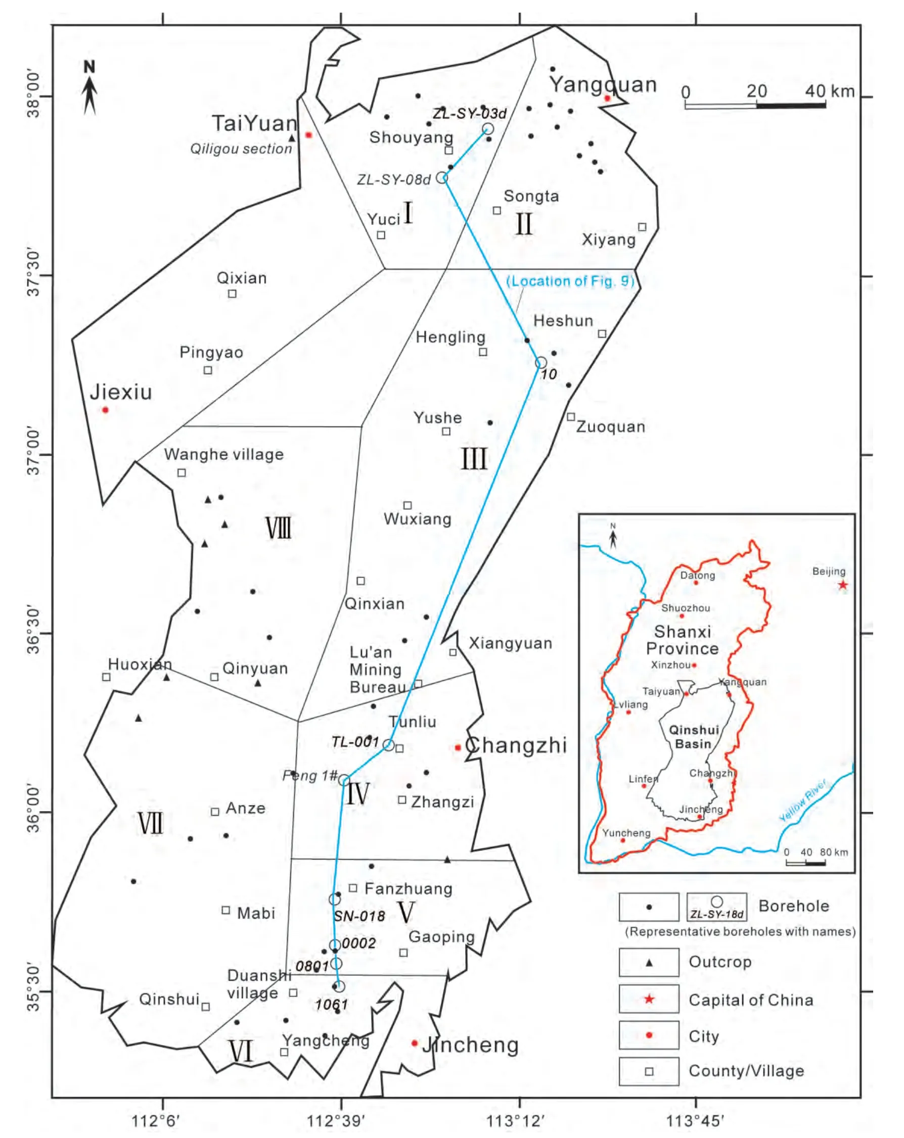
Figure 1 Division of the mining and exploration areas in the Qinshui Basin. I-Shouyang area; II-Yangquan area; III-Heshun-Zuoquan area; IV-Tunliu-Zhangzi area; V-Gaoping-Fanzhuang area; VI-Jincheng area; VII-Anze-Qinshui area; VIII-Qinyuan area. Only some representative studied outcrops and boreholes are shown with names, while others only with the location.
Tectonically, the Qinshui Basin was located in the eastern part of the Lvliang-Taihang fault block. During the Carboniferous and Permian, the Qinshui Basin was part of the North China Basin, which was a great cratonic depositional basin. The present Qinshui Basin is a residual structural basin that was formed by continuous shearing and continuous expansion of the uplifts during the Yanshanian (Late Jurassic to Early Cretaceous) orogeny (Hsü, 1989). This shearing and compressive stress intensified during the Yanshanian period, and as a result, the great North China Basin gradually retreated towards the Ordos area to the west. The Shanxi block became an uplifted area at the middle stage of the Yanshanian orogeny, accompanied by a final consolidation of the Qinshui Basin, a superimposed synclinorium(Chen and Liu, 1998).
The strata of the Carboniferous and Permian include the Benxi, Taiyuan, Shanxi, Xiashihezi, Shangshihezi, and Shiqianfeng Formations in ascending order (Fig. 2), which were generally formed in a transitional marine and non-marine cratonic basin (Han and Yang, 1980). The boundary between the Late Carboniferous and Permian is located at the base of the Miaogou Limestone marker of the Taiyuan Formation(Konget al., 1996). The coal-bearing series include the Late Carboniferous Benxi Formation, the Late Carboniferous to Early Permian Taiyuan Formation, and the Early Permian Shanxi Formation. The Benxi and Taiyuan Formations are composed of sandstone, siltstone, and mudstone, interbedded with typical marine bioclastic limestones, as well as coal seams, which were formed in a tidal flat-lagoon setting(Liuet al., 1998). The Shanxi Formation consists of sandstone, siltstone, and mudstone, and mineable coal seams,which were deposited in a typical delta environment. The regionally stable, major mineable No. 15 and No. 3 coals were developed in the Taiyuan and Shanxi Formations, respectively. The Xiashihezi (Middle Permian), Shangshihezi(Middle to Late Permian), and Shiqianfeng (Late Permian)Formations are composed of sandstones, siltstones, and typical purple mudstones, which were formed in the fluvial system and lacustrine-dominated system and in an arid to semi-arid climate.
3 Methods
The database for this study consists of 98 fully cored boreholes and outcrop sections, which cover most of the Qinshui Basin (Fig. 1). Lithofacies were described on the basis of depositional characteristics including lithology(hand specimen and thin section), sedimentary structures,fossils, logging curves, and sandbody geometries. Lithofacies were arranged into different depositional systems,which were described and correlated in a north-south sedimentary cross section. The analytical contour maps include the strata thickness, sandstone thickness, sandstone percentage, sandstone/mudstone ratio (sandstone and conglomerate/siltstone and mudstone), mudstone thickness,limestone thickness, and total coal thickness. The isopachs of strata generally reflect the distribution of subsiding and uplifting areas, and the sandstone thickness and percentages can indicate the main direction of the provenances and reveal the distribution of the main channels and the fluvial sand bodies (Feng, 1992, 2004; Fenget al., 2014). The sandstone/mudstone ratio can reflect the outline of the palaeogeography and framework facies, and the isopachs of marine limestones can indicate the direction and scope of transgression. The isopachs of coal seams can reflect the distribution of coal-forming mires and coal-accumulating centers (Shaoet al., 2003, 2008a, 2009; Zhanget al., 1993). The palaeogeographic maps were mainly based on the sandstone/mudstone ratio contours and limestone isopachs and modified by other parameters such as the sandstone isopachs and mudstone isopachs. The time intervals used for the palaeogeographical reconstruction corresponded to the deposition of the lithological formations,including the Benxi Formation, Taiyuan Formation, Shanxi Formation, Xiashihezi Formation, Shangshihezi Formation,and Shiqianfeng Formation.
4 Lithofacies and depositional systems
4.1 Lithofacies characteristics
The lithofacies and depositional systems of the Carboniferous and Permian in the Qinshui Basin were analyzed on the basis of outcrop sections and borehole cores and in a north-south sedimentary section. Using lithological and palaeontological characteristics, as well as geometry and lateral relationships, a total of 22 types of distinct lithofacies were identified, and some of their characteristics are shown in Figures 3-5. Their salient features and probable sedimentary interpretations are summarized in Table 1.These 22 lithofacies belong to the following 6 major lithological types.
Conglomerate: Conglomerates are mainly fine- to medium-grained, thin-bedded, and compositionally immature(Fig. 3a). The conglomerates are less developed in the Carboniferous and Permian, and they were only formed as the channel lag deposits in some horizons of the Shangshihezi Formation.
Sandstone: Sandstones in the research area are mainly grayish white, grayish brown, and gray, and they are developed with a variety of cross-bedding. The sandstones can be seen in the whole successions of the Carboniferous and Permian, and they were formed in the meandering fluvial channel, distributary channel of the delta plain,delta front, barrier bar, and tidal flat environments. The lithofacies belonging to sandstones include trough crossbedded sandstone (Fig. 3e, 3f), parallel-bedded sandstone,wavy cross-bedded sandstone (Fig. 3c), massive sandstone beds (Figs 3d, 4c), wedge cross-bedded sandstone (Fig. 4a),sandstone with flaser beddings (Fig. 4d, 4g), and tabular cross-bedded sandstone (Figs 3b, 4b).
Siltstone: Siltstones in the research area are mainly grayish brown and grayish black, and developed with ripple and horizontal laminations, sometimes with root traces and plant fragment fossils. Siltstones are widely found in all lithological formations of the Carboniferous and Permian, and they were mainly deposited in a low energy environment,such as the levee, crevasse splay, flood basin, interdistributary bay, delta front, tidal flat, and lagoon environments.The lithofacies belonging to siltstones include horizontally bedded siltstone (Fig. 4e, 4f), massive siltstone beds, and wavy cross-bedded siltstone (Fig. 4h).
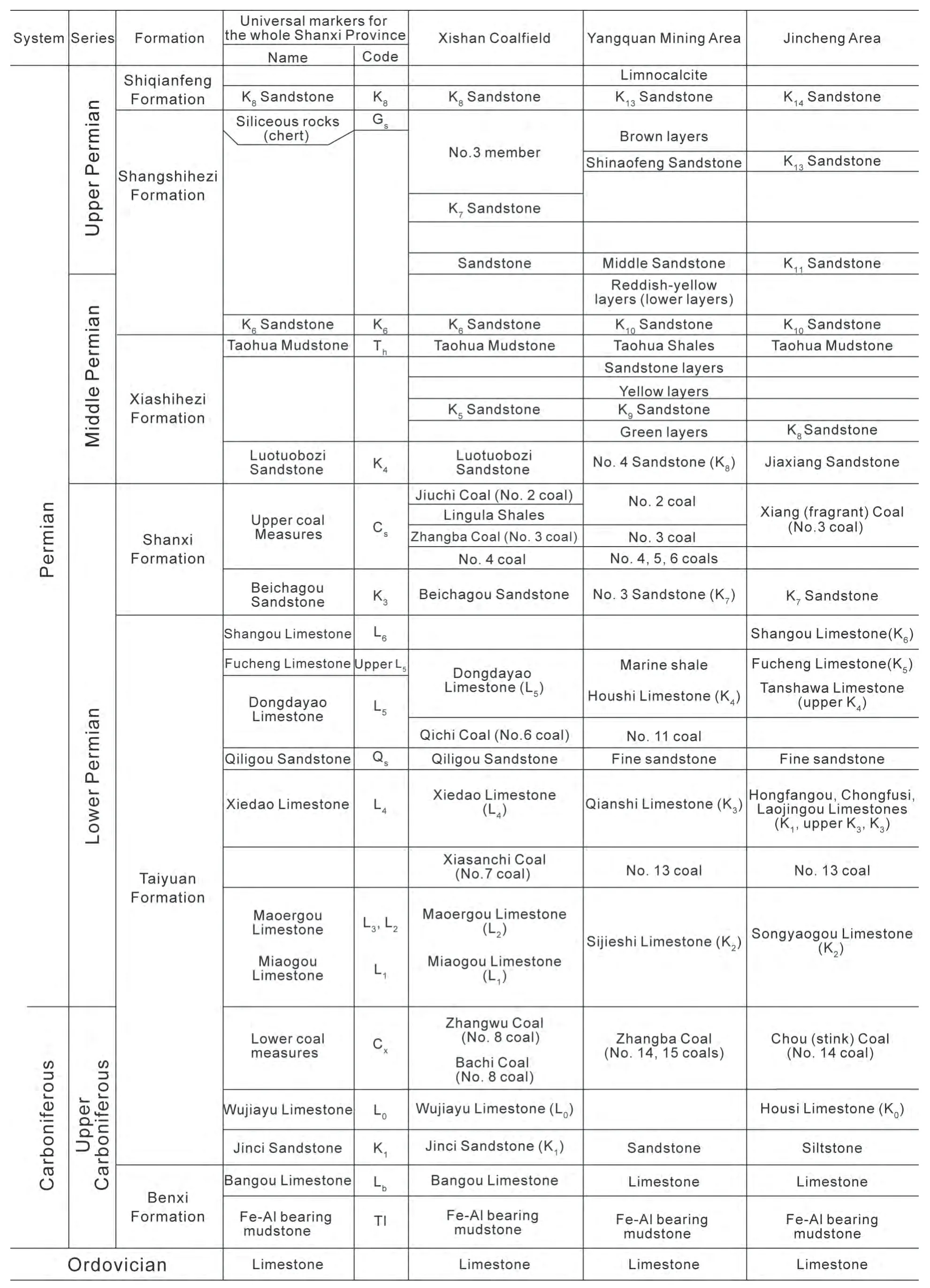
Figure 2 Stratigraphic subdivision and sub-correlation of the Carboniferous and Permian strata in the Qinshui Basin (modified after Cheng, 1992 and CNACG, 1997).
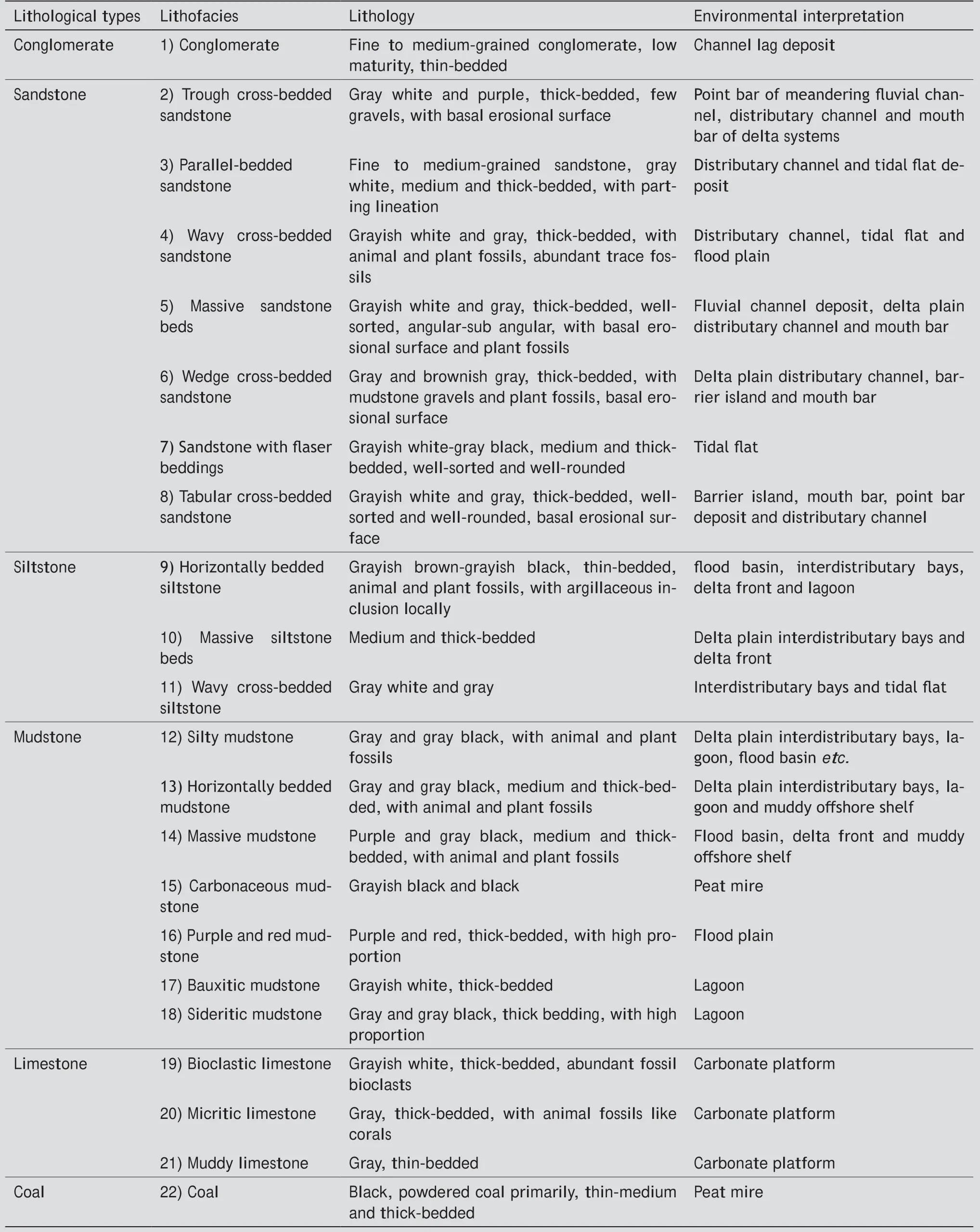
Table 1 Lithofacies of the Carboniferous and Permian in Qinshui Basin, Shanxi Province, China
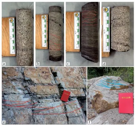
Figure 3 Lithofacies of the Carboniferous and Permian in the Qinshui Basin. a-Conglomerate, Taiyuan Formation (Borehole Y5-2, Taiyuan Xishan Coalfield); b-Tabular cross-bedded sandstone, Taiyuan Formation (Borehole 7-14, Taiyuan Xishan Coalfield); c-Wavy cross-bedded sandstone, Taiyuan Formation (Borehole Y5-2, Taiyuan Xishan Coalfield); d-Massive sandstone beds, Shanxi Formation (Borehole 7-14,Taiyuan Xishan Coalfield); e-Trough cross-bedded sandstone, Shanxi Formation (Qiligou section, Taiyuan Xishan Coalfield); f-Trough crossbedded sandstone, Shanxi Formation (Qiligou section, Taiyuan Xishan Coalfield). Booklet size = 127 × 182 mm2.
Mudstone: According to color, mixture composition, and sedimentary structures, mudstones can be subdivided into silty mudstone, horizontally bedded mudstone (Fig. 5a,5b), massive mudstone (Fig. 5c), carbonaceous mudstone(Fig. 5d, 5j), purple and red mudstone (Fig. 5e), bauxitic mudstone (Fig. 5i), and sideritic mudstone. They were normally formed in the flood basin, delta plain interdistributary bay, delta front, lagoon, and peat mire environments.Mudstones are widely found in all formations of the Carboniferous and Permian.
Limestone: The limestone can be subdivided into bioclastic limestone (Fig. 5h), micritic limestone (Fig. 5f), and muddy limestone (Fig. 5g). Bioclastic limestone is grayish white and thick-bedded, with abundant marine fossils and fossil fragments. Micritic limestone is gray and thick-bedded, with coral and fusulinid fossils. Muddy limestone is gray and thin-bedded, with abundant terrestrial siliciclastic clay. Limestones are mainly developed in the Benxi and Taiyuan Formations, and they were formed in a carbonate platform environment.
Coal: The main coal-forming environment in the research area was the mires formed in a tidal flat-lagoon environment and an interdistributary bay environment. The coals are primarily developed in the Taiyuan and Shanxi Formation (Fig. 5k) and less developed in the Benxi Formation. No coals are found in the other formations.
4.2 Depositional systems
Twenty-two distinct lithofacies (Table 1) have been interpreted to have been formed in environments ranging from piedmont fluvial channel to fully subaqueous lacustrine environments, which collectively represent an epi-continental basin setting with transitional marine to non-marine depositional environments. Five depositional systems are proposed:(1) fluvial, (2) delta, (3) lacustrine, (4) tidal flat-lagoon,and (5) carbonate platform (Table 2). Each of these depositional systems has its own sedimentary facies and subfacies. The distribution of these depositional systems and sedimentary facies in several of our representative studied outcrop and borehole sections are shown in Figures 6-8.
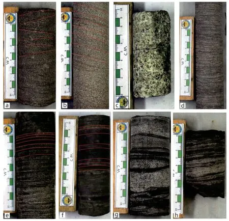
Figure 4 Lithofacies of the Carboniferous and Permian in the Qinshui Basin. a-Wedge cross-bedded sandstone, Taiyuan Formation (Borehole 7-14, Taiyuan Xishan Coalfield); b-Tabular cross-bedded sandstone, Taiyuan Formation (Borehole 7-14, Taiyuan Xishan Coalfield); c-Massive sandstone beds, Shanxi Formation (Borehole 7-14, Taiyuan Xishan Coalfield); d-Sandstone with flaser beddings, Taiyuan Formation(Borehole 7-14, Taiyuan Xishan Coalfield); e-Horizontally bedded siltstone, Taiyuan Formation (Borehole 7-2, Taiyuan Xishan Coalfield);f-Horizontally bedded siltstone, Shanxi Formation (Borehole 7-14, Taiyuan Xishan Coalfield); g-Sandstone with flaser beddings, Shanxi Formation (Borehole 2-7, Taiyuan Xishan Coalfield); h-Wavy cross-bedded siltstone, Taiyuan Formation (Borehole 7-14, Taiyuan Xishan Coalfield).
4.2.1 Fluvial depositional system
Fluvial channel sandstones are laterally continuous and associated with well-developed overbank and flood basin deposits (Fig. 6a). The deposits of this system are mainly found in the Shangshihezi Formation of the Qinshui Basin.The lenticular sandy conglomerates with erosional bases represent channel lag deposits. The channel lag deposits grade upwards into point bar deposits, which are composed of laterally continuous sand bodies with tabular cross-bedding and also parallel and trough cross-bedding. The finegrained sandstones and siltstones and intercalated reddishcolored mudstone layers usually make overbank deposits,which are developed with ripple lamination or, more typically, climbing ripple laminations. Root traces can be seen in these deposits. The thinly interbedded siltstones and mudstones, in association with the sideritic concretions,indicate a flood basin environment.
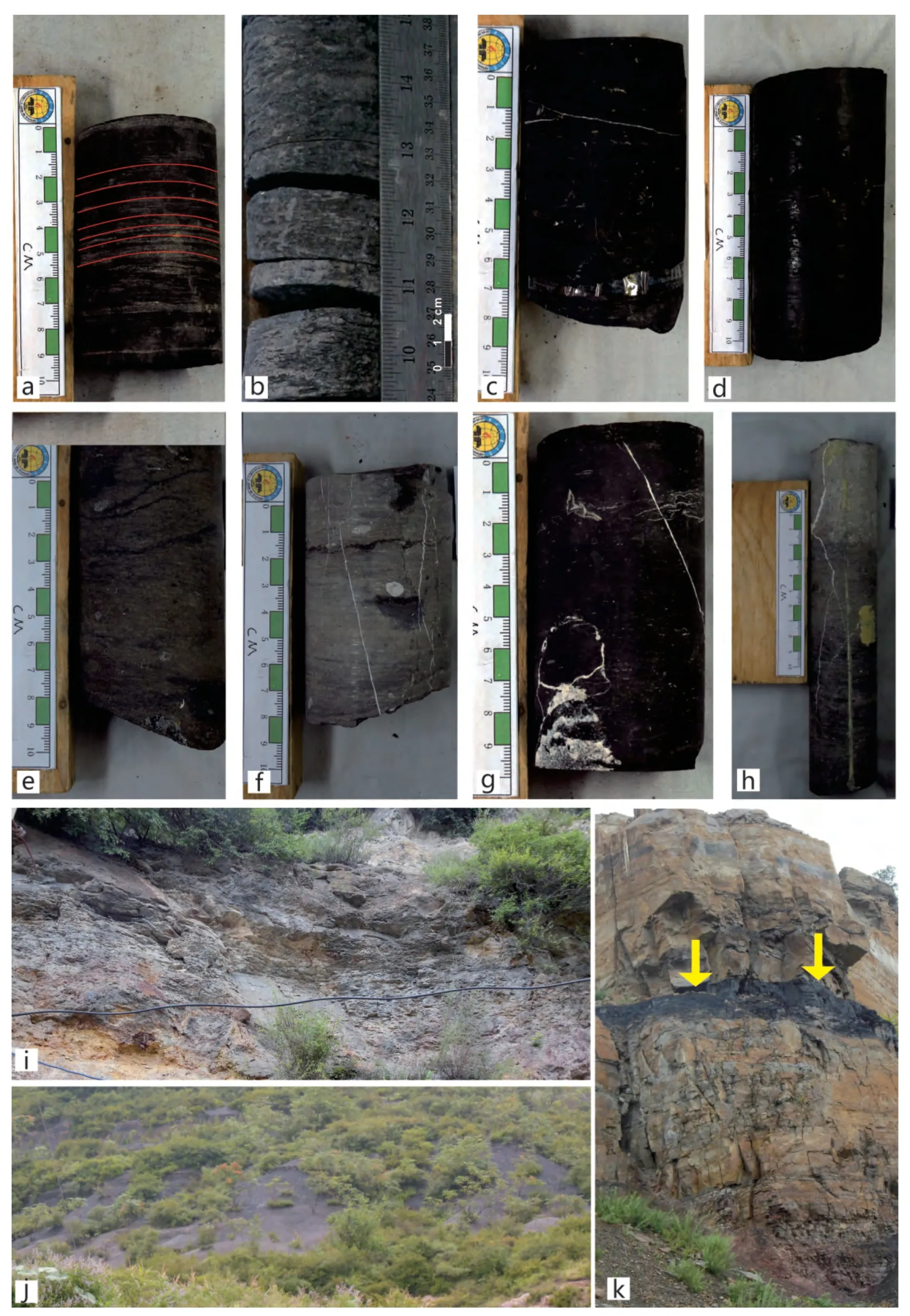
Figure 5 Lithofacies of the Carboniferous and Permian in the Qinshui Basin. a-Horizontally bedded mudstone, Taiyuan Formation (Borehole Y5-2, Taiyuan Xishan Coalfield); b-Horizontally-bedded mudstone, Taiyuan Formation (Borehole SX-306, Taiyuan Xishan Coalfield);c-Massive mudstone, Taiyuan Formation (Borehole 9-2, Taiyuan Xishan Coalfield); d-Carbonaceous mudstone, Taiyuan Formation (Borehole 7-14, Taiyuan Xishan Coalfield); e-purple and red mudstone, Taiyuan Formation (Borehole Y5-2, Taiyuan Xishan Coalfield); f-Micritic limestone, Taiyuan Formation (Borehole 7-2, Taiyuan Xishan Coalfield); g-Muddy limestone, Taiyuan Formation (Borehole 7-14, Taiyuan Xishan Coalfield); h-Bioclastic limestone, Taiyuan Formation (Borehole 7-14, Taiyuan Xishan Coalfield); i-Bauxitic mudstone, Benxi Formation (Qiligou section, Taiyuan Xishan Coalfield); j-Carbonaceous mudstone, Shanxi (Qiligou section, Taiyuan Xishan Coalfield); k-Coal,Shanxi Formation (No. 3 coal, Qiligou section, Taiyuan Xishan Coalfield).
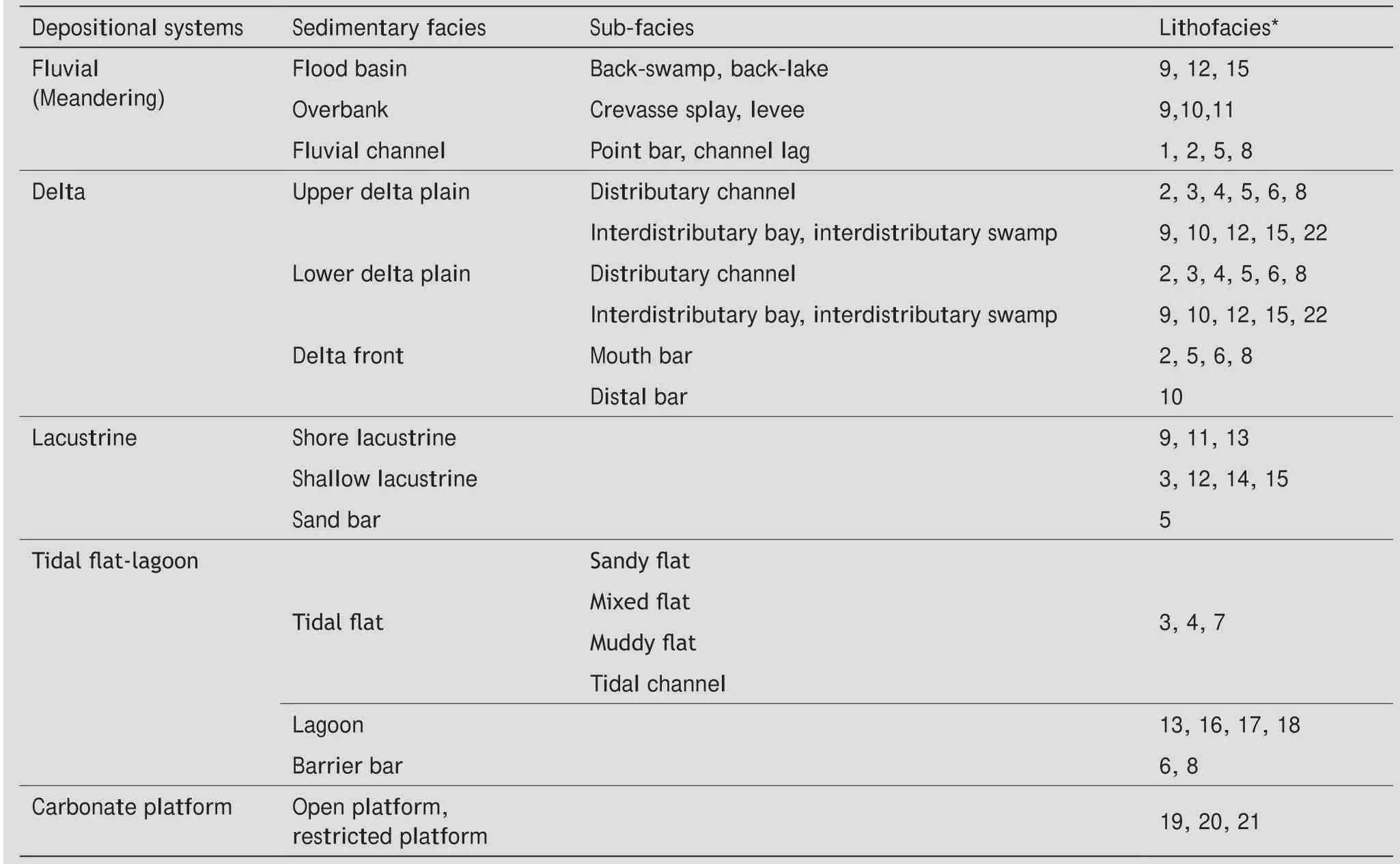
Table 2 Depositional systems and corresponding facies/subfacies of the Carboniferous and Permian in the Qinshui Basin
4.2.2 Delta depositional system
Sheet-like channel sand bodies interbedded with darkcolored fine-grained subaqueous sediments and coals constitute an overall upward-coarsening succession of this system (Fig. 6b). The upper delta plain facies is represented by the Xiashihezi Formation in the entire Qinshui Basin, and is typically characterized by the thick and cross-bedded sandstones of fluvial channel facies, the ripple laminated siltstones of the levee and crevasse splay facies, and the red and multi-colored mudstones intercalated with thin carbonaceous mudstones of the interdistributary flood basin facies. The lower delta plain facies is represented by the Shanxi Formation and upper part of the Taiyuan Formation, and comprises sandstones of distributary channel facies, as well as thinly interbedded carbonaceous mudstones,siltstones, and sideritic sandstones of the interdistributary bay facies. The sandstones are developed with large-scale cross-bedding and erosional bases associated with mudstone gravels and fossil tree trunks. Coal-forming mires are often well developed in the lower delta plain where they initially tended to form in an interdistributary bay and subsequently developed to occupy most areas of the lower delta plain during periods of delta abandonment. As a consequence, the lower delta plain has a typical vertical intercalation of coal, mudstone, siltstone and sandstone,showing saw-like well log curves. The No. 3 coal seam with a stable regional distribution was formed in the interdistributary bay environments of the lower delta plain. The delta front facies, in this study, represent the subaqueous parts of the delta. The delta front comprises subaqueous,distributary channel, massive to cross-bedded, calcite-cemented sandstones, mouth bar sandstones and siltstones with planar cross-bedding and ripple laminations, and distal bar sheet-like ripple laminated siltstones. The pro-delta deposits are mainly silty mudstones and thin-bedded siderite or sideritic mudstone layers with ripple or horizontal laminations.
4.2.3 Lacustrine depositional system
Lacustrine deposits are well developed in the Shangshihezi and Shiqianfeng Formations and are particularly important in the mudstone members of these formations.They consist of mainly brownish gray, and reddish mudstones with horizontal laminations. The sandstones with low-angle cross-bedding are considered to be longshore bar deposits of the coastal lake. The grayish bioturbated siltstones, intercalated with mudstones, were interpreted to be bars in a shallow lake. The thick-bedded red or purple mudstones represent a fairly shallow lacustrine facies(Fig. 8; Table 1). All these lacustrine deposits can pass into sandstone-rich fluvial channel belts and therefore can be attributed to the inter-fluvial lake system or back-lake facies of the fluvial system.
4.2.4 Tidal flat‑lagoon depositional system
The lagoonal sedimentary facies were mainly developed in the Benxi and Taiyuan Formations. The typical lagoonal deposits in these formations consist of carbonaceous mudstones and bauxitic mudstones which are developed with horizontal laminations, or no bedding planes, and siderite nodules, and scarce marine fossil fragments (Fig. 6c). The sandstones interbedded with these mudstones are developed with planar beds and also lenticular beds, and can be regarded as sand-rich barrier bar and tidal flat deposits.
4.2.5 Carbonate platform system
The deposits of this system are represented by limestone marker beds, which are well developed in the Taiyuan Formation (Fig. 6d). Abundant marine fossils such as fusulinids,crinoids, and brachiopods, were found in this formation.Some trace fossils ofZoophycosandPlanolitescan also be seen in these limestones (Huet al., 2013).
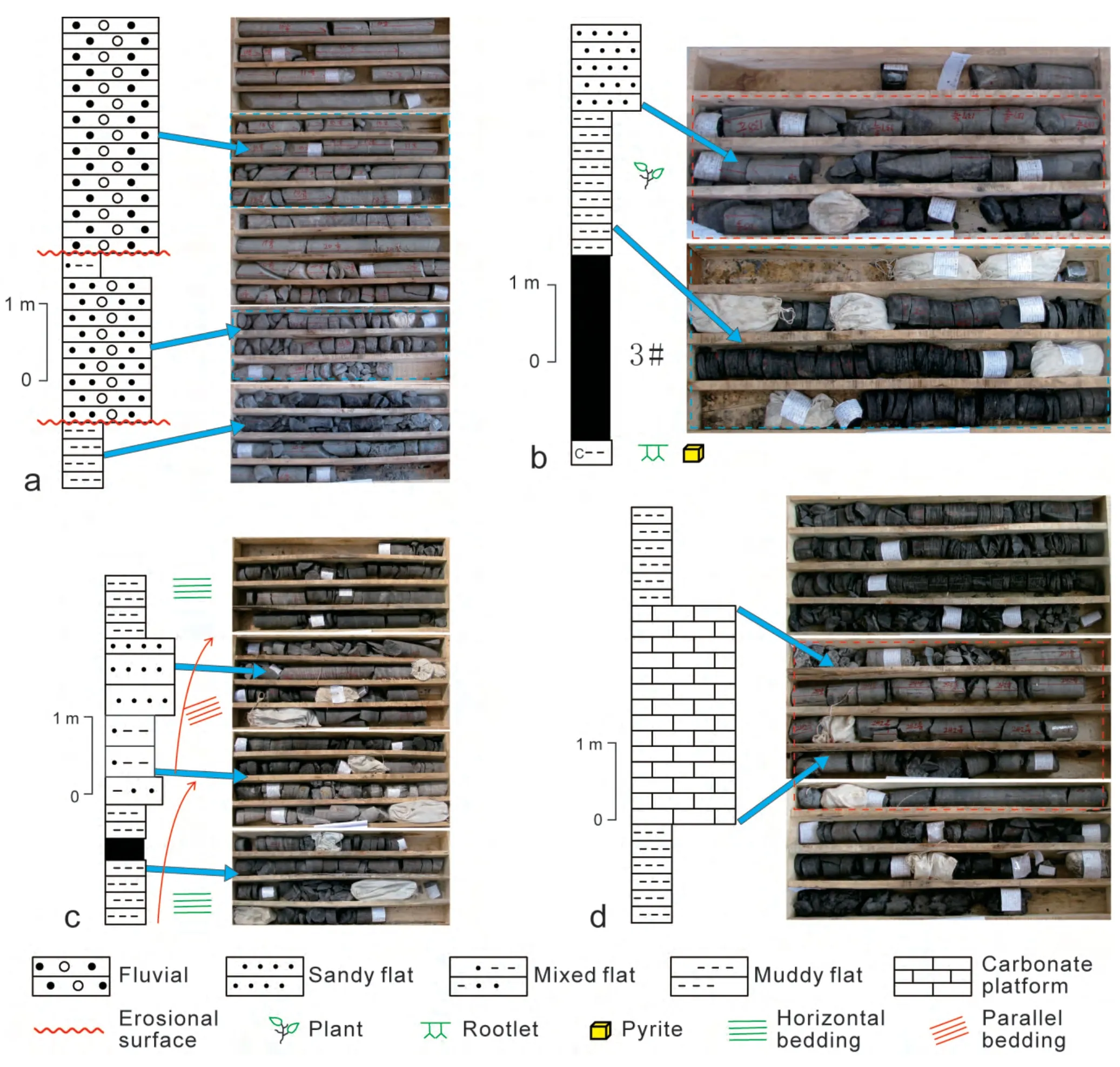
Figure 6 Depositional systems of the Carboniferous and Permian in the Qinshui Basin (Borehole SX-306). a-Fluvial; b-Delta; c-Tidal flat-lagoon; d-Carbonate platform.
4.3 Lateral distribution of the depositional systems
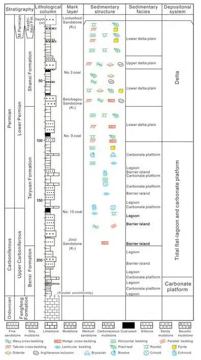
Figure 7 Columnar section showing sedimentary facies of the coal-bearing successions of the Carboniferous and Permian in the Shouyang area of the Qinshui Basin.
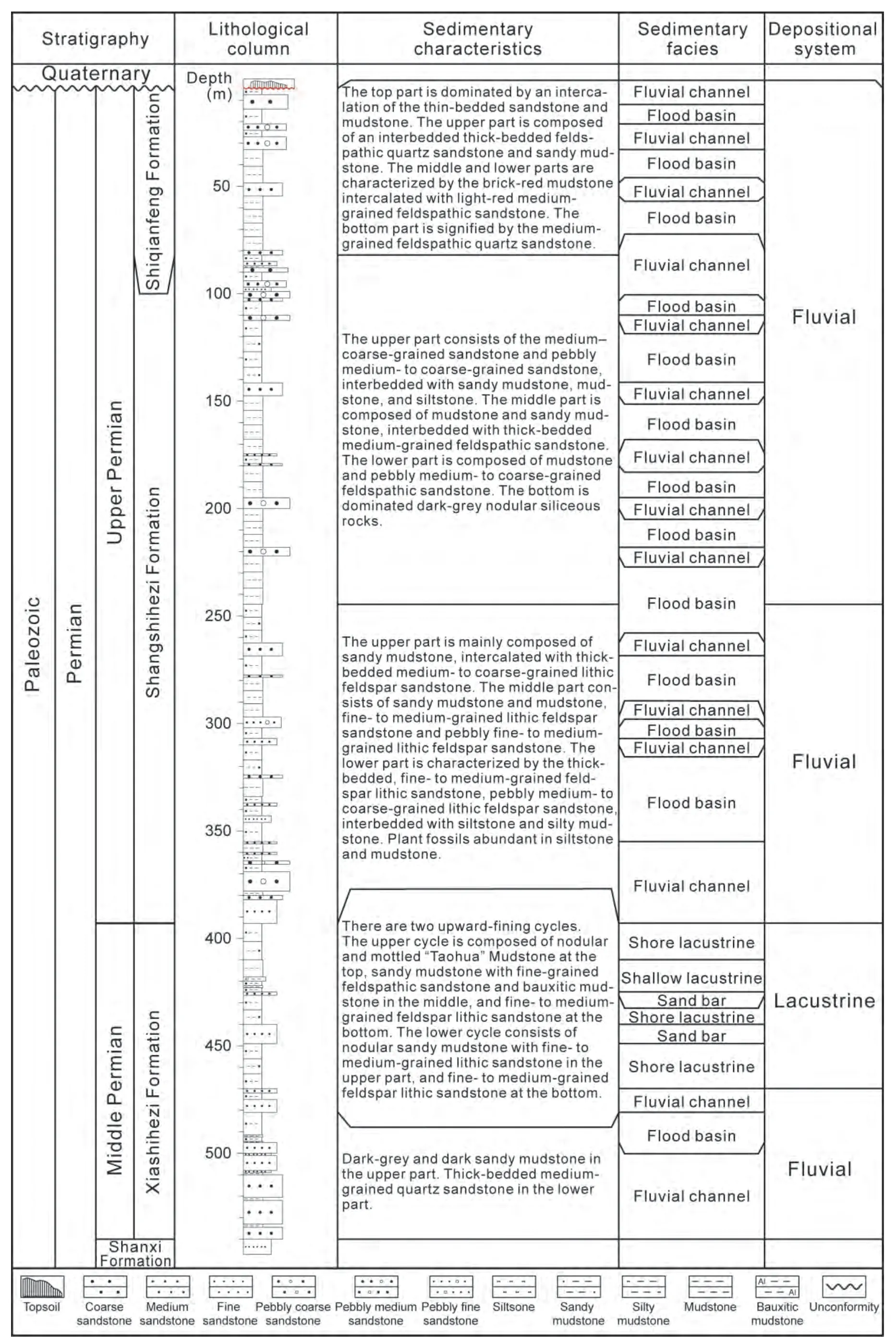
Figure 8 Columnar section showing sedimentary facies at the Qiligou section of the Taiyuan Xishan Coalfield.
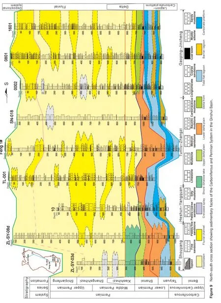
The north-south cross section can be used to analyze the lateral distribution of sedimentary systems in the Qinshui Basin (Fig. 9). The sedimentation in the Benxi and Taiyuan Formations was mainly dominated by a tidal flat-lagoon depositional system and a carbonate platform depositional system. During the deposition of the Taiyuan Formation,the northern zone was developed with a lower delta plain environment, the central and south parts were dominated by a barrier bar and lagoonal environment, while the southeastern corner was occupied by a carbonate platform. The conditions for the accumulation of coal gradually became unstable from the northern to southern part.During the deposition of the Shanxi Formation, most of the Qinshui basin was dominated by a delta depositional system: the northern part was mainly occupied by an upper delta plain environment, the central part was constituted mainly of a lower delta plain environment, and the southeastern part was occupied by a delta front environment.Coal seams were thicker in the central and southern parts than in the northern zone. During the deposition of the Xiashihezi Formation, the Qinshui Basin was mainly occupied by a fluvial depositional system, the northern and southern parts were dominated by flood basins, while the central,northeastern, and central-southern parts were mainly occupied by fluvial channels. As interpreted from the sedimentary environment, the conditions for the accumulation of coal seams were not favorable during this period, since only thin coal seams can be found in some areas. During the deposition of the Shangshihezi Formation, the Qinshui Basin was also dominated by a fluvial depositional system.Most of the basin was occupied by a flood basin, and only the northern and southern parts consisted of fluvial channels. The conditions for the accumulation of coal seams were very unfavorable; hence, no coal seams can be found in this formation.
5 Palaeogeographic maps
5.1 Lithofacies palaeogeography of the Benxi Formation
5.1.1 Lithofacies palaeogeography analysis of the Benxi Formation
The palaeogeographic analysis of the lithofacies in our study was mainly based on the contour map of the sandstone/mudstone (S/M) ratio, supported by the contour maps of other individual lithological parameters such as formation thickness, mudstone thickness, sandstone thickness, and limestone thickness.
The Benxi Formation in the Qinshui Basin consists of sections ranging from the basal unconformity of the Upper Carboniferous to the bottom of Jinci Sandstone in the overlying Taiyuan Formation. The Benxi Formation is composed of carbonaceous mudstones, limestones, conglomerates,and bauxitic mudstones. The carbonaceous mudstones are brown and black in color, and can be found with or without horizontal laminations. The conglomerates are gray to white-gray and brecciated, and are rarely seen in this formation. The bauxitic mudstones are dense and massive and are light gray to gray in color, with coaly debris and pyrite concretion on the top.
Within the boreholes selected for our study, the total thickness of the Benxi Formation ranges from 5 m to 52.8 m, averaging 20 m, with the maximum thickness being found in the Shouyang-Yangquan area (being 52.8 m) (Fig. 10). The total thickness of the Benxi Formation shows a decrease from north to south. The total thickness of limestones varies between 1.2 m and 8.8 m, averaging 4.4 m, with the maximum thickness in the Xiyang-Heshun-Zuoquan area on the eastern edge of the basin, as well as the Fushan-Jiexiu area in the southwestern part of the basin, indicating transgression of the Benxi Formation into a northeastern direction (Fig. 11). The total thickness of the sandstones ranges from 0 m to 27.1 m,averaging 3.4 m, with the maximum thickness being found in the Shouyang-Yangquan area near the northern part,and the Duanshi-Mabi area in the southern part of the basin (Fig. 12). The percentages of sandstones vary between 0% and 68%, averaging 14%, with the highest percentage near the Shouyang-Yangquan area and the Duanshi-Mabi area (Fig. 13). The S/M ratios of the Benxi Formation vary between 0 and 3.25, averaging 0.32, with the highest value near the Shouyang-Yangquan area and the Duanshi-Mabi area in the southern part of the basin (Fig. 14). From these contour maps, it can be seen that two sandstone-rich zones existed in the Qinshui Basin. One of these sandstonerich zones is located in the Shouyang-Yangquan area in the northern part of the Basin, and the other is located in the Duanshi-Mabi area.

Figure 10 Isopach map showing the total thickness of the Benxi Formation in the Qinshui Basin.
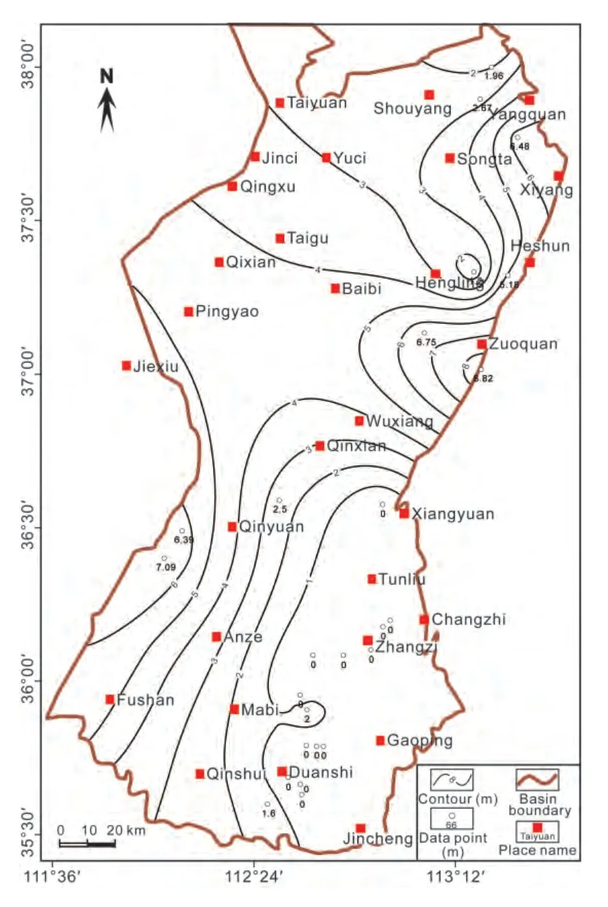
Figure 11 Isopach map showing the total thickness of limestone of the Benxi Formation in the Qinshui Basin.
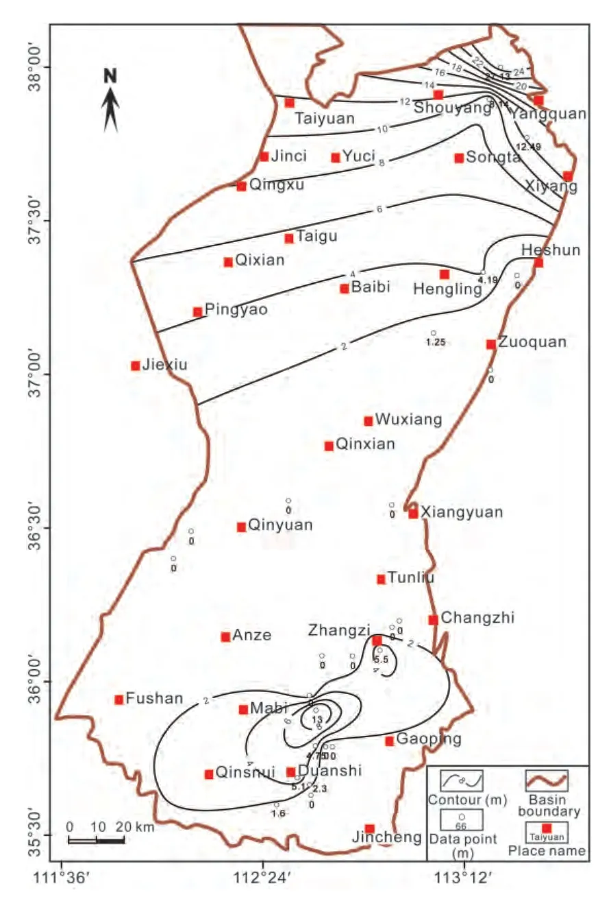
Figure 12 Isopach map showing the total thickness of sandstones in the Benxi Formation of the Qinshui Basin.
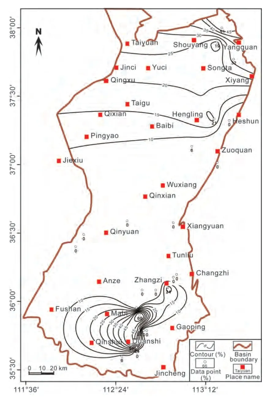
Figure 13 Contour map of percentages of sandstones in the Benxi Formation of the Qinshui Basin.
5.1.2 Palaeogeographic map of the Benxi Formation
The palaeogeographic map of the Benxi Formation was reconstructed based on the above-mentioned contour maps, as well as on the analysis of the sedimentary facies in the outcrop and borehole sections (Fig. 15). The total thickness of the Benxi Formation diminishes from north to south, which indicates that the source of the sediment was an uplifted area that existed towards the southern part of the basin during the deposition of the Benxi Formation. Most areas of the Qinshui Basin were dominated by a lagoonal environment, which is manifested by the basin-wide distribution of the mudstones. The barrier bar environments were indicated by the two sandstone-rich zones, near the northeastern part around the Shouyang-Yangquan area and in the southern part around the Duanshi-Mabi area, respectively. The limestone-rich zones,represented by the Zuoquan-Heshun-Xiyang area and the Fushan-Jiexiu area, denote the carbonate platform environments. Considering the Late Carboniferous palaeogeography of the great northern China Basin, which saw a marine transgression from the northeastern direction(CNACG, 1997), it was inferred that the Qinshui Basin also had a northeasterly transgression during deposition of the Benxi Formation.
5.2 Lithofacies palaeogeography of the Taiyuan Formation
5.2.1 Lithofacies palaeogeography analysis of the Taiyuan Formation
The Taiyuan Formation in Qinshui Basin consists of sections from the base of the Jinci Sandstone to the bottom of Beichagou Sandstone of the Shanxi Formation.The Taiyuan Formation is composed of limestones, fine to medium-grained sandstones, siltstones, silty mudstones,carbonaceous mudstones, and coal seams. The limestone markers, namely the “Miaogou”, “Maoergou” and“Fucheng” Limestones, are mainly bioclastic limestones,which were widely developed with marine fossils such as brachiopods, fusulinids, and crinoids (IGE-CCMRI/SPCEC,1987), as well as trace fossils such asZoophycosandRhizocorallium(Huet al., 2013). These characteristics suggest that the limestones were mainly deposited in the carbonate platform environment. The gray mudstones,siltstones and sandstones in this formation contain abundant lenticular, nodular, or bedded siderites and sideritic mudstones, developed with horizontal bedding and lenticular bedding, as well as burrows. These characteristics indicate that these mudstones, siltstones, and sandstones were formed in a lagoonal setting. The medium- to fine-grained quartz sandstones in the Taiyuan Formation have a high compositional maturity and a moderateto-good sorting, commonly developed with large-scale cross-bedding, especially low-angle cross-bedding. These sandstones normally develop with an upward-coarsening succession and are believed to be tidal flat sand bar deposits. In summary, it can be concluded that the Taiyuan Formation represents carbonate platform, lagoonal, and tidal flat environments.
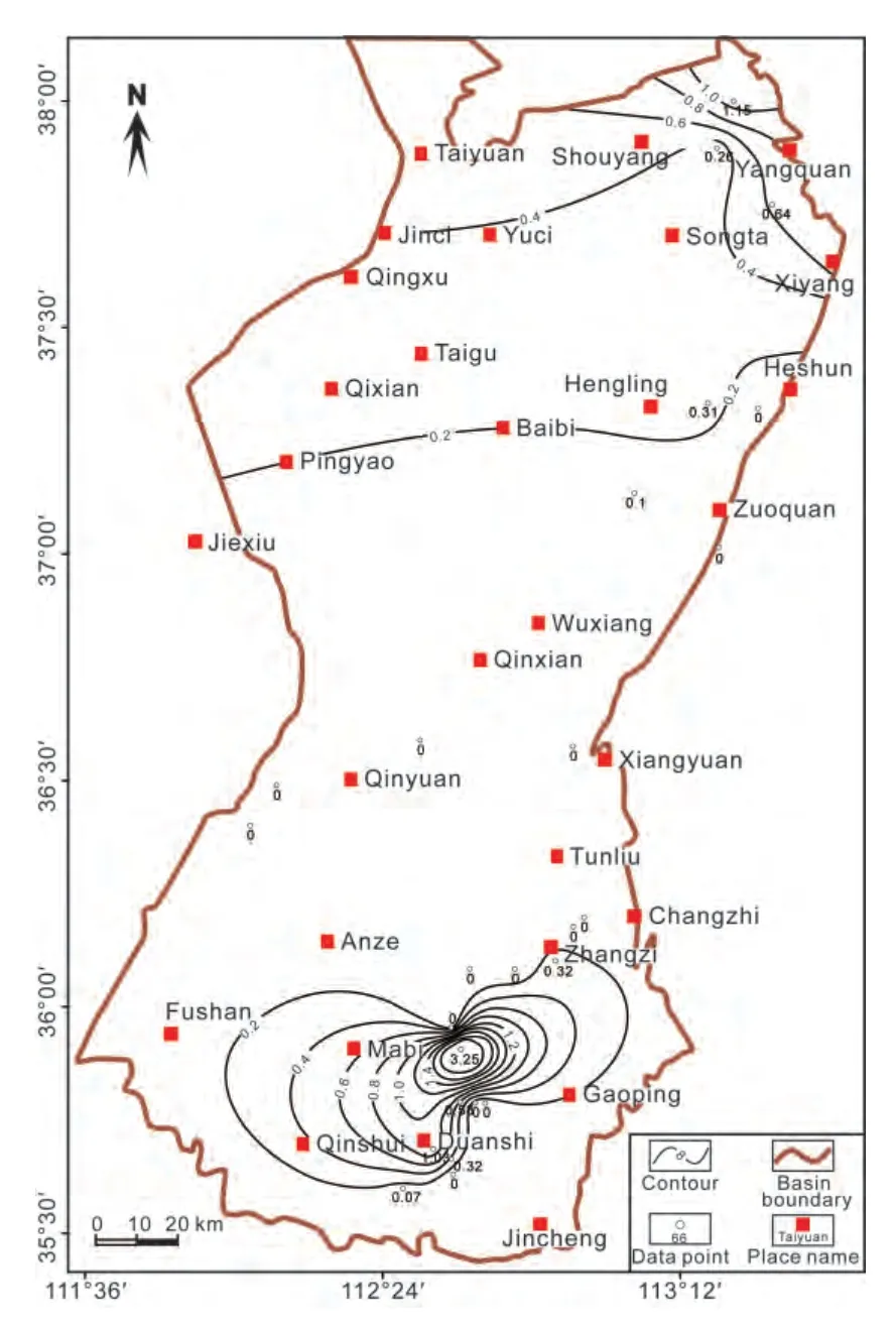
Figure 14 Contour map of the sandstone/mudstone ratio of the Benxi Formation in the Qinshui Basin.
Within the selected boreholes, the total thickness of the Taiyuan Formation varies between 29 m and 207.4 m, averaging 104.6 m, with the maximum thickness in some boreholes in the Shouyang area being 207.4 m (Fig. 16). Figure 16 also shows a trend of decreasing thickness from the Taiyuan-Shouyang-Zuoquan area to the southwest and from the Qinyuan and Jincheng-Gaoping-Zhangzi area to the middle of the Tunliu-Mabi area in the central and southern parts. A total of 3 thicker zones can be identified from the isopach map of the Taiyuan Formation, which include the Taiyuan-Shouyang-Zuoquan area, the Qinyuan area, and the Jincheng-Gaoping-Shouyang-Yangquan area. This formation is generally thinner in the southern part of the basin and thicker in the northern part, with the central part being the thinnest.
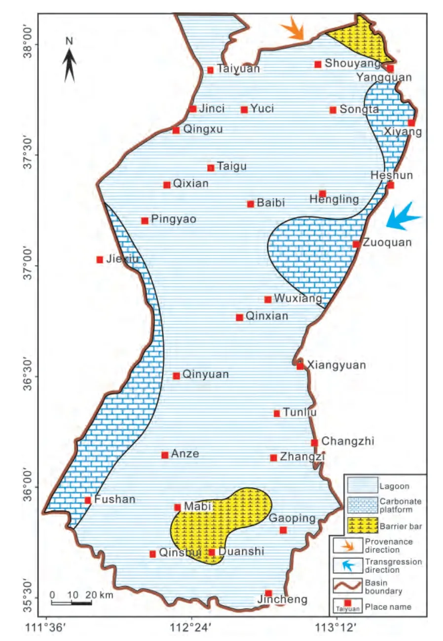
Figure 15 Lithofacies palaeogeography of the Benxi Formation in the Qinshui Basin.
The total thickness of limestones varies from 0 m to 28 m, averaging 14 m, with the greatest thickness in the Gaoping-Jincheng area, indicating that the transgression came from southeast during the deposition of the Taiyuan Formation (Fig. 17). The coal in this formation has a total thickness from 0.7 m to 17.3 m, averaging 7.1 m, with the thickest coal distributing around the Yangquan area in the north of the Qinshui Basin (Fig. 18). The total thickness of sandstones varies between 4.5 m and 81.1 m, averaging 27 m, with the maximum thickness in the Taiyuan-Shouyang-Yangquan area (Fig. 19). These sandstone isopach maps reveal a northerly provenance for the Taiyuan Formation, which is in consistency with an overall northern Yinshan palaeocontinent provenance for the North China Platform during the Carboniferous and Permian (CNACG,1997). The percentages of sandstones range between 5%and 56%, averaging 24%, with the highest percentage in the Taiyuan-Shouyang-Yangquan area (Fig. 20) showing a similar trend with the isopachs of the sandstones.
The contours of the S/M ratios of the Taiyuan Formation show that there are two sandstone-rich zones in the north and south of the Basin, respectively (Fig. 21). The northern sandstone-rich zone is mainly located to the north of Qinxian, including the Pingyao, Taigu, Shouyang, Yangquan,and Xiyang areas. The S/M ratios in this zone are commonly higher than 0.4, with the maximum ratio up to 1.0 in the Shouyang and Heshun areas, except the narrow area along the Qinxian-Wuxiang-Yushe area in which the S/M ratios are lower than 0.4. In contrast to the northern zone, the southern zone has generally lower S/M ratios, except the northern side of the Qinyuan and Gaoping-Jincheng areas where the S/M ratios are higher than 0.4.
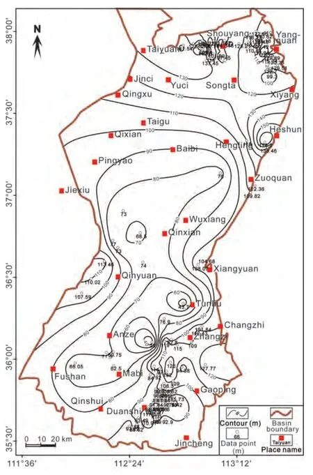
Figure 16 Isopach map showing the total thickness of the Taiyuan Formation in the Qinshui Basin.
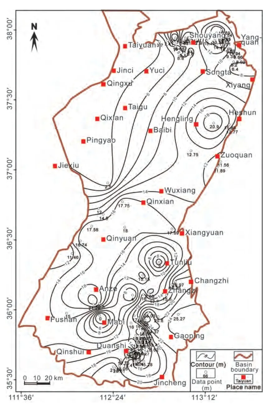
Figure 17 Isopach map showing the total thickness of limestones of the Taiyuan Formation in the Qinshui Basin.

Figure 18 Isopach map showing the total thickness of coals of the Taiyuan Formation in the Qinshui Basin.
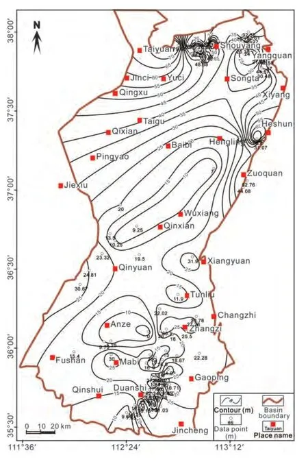
Figure 19 Isopach map showing the total thickness of sandstones of the Taiyuan Formation in the Qinshui Basin.
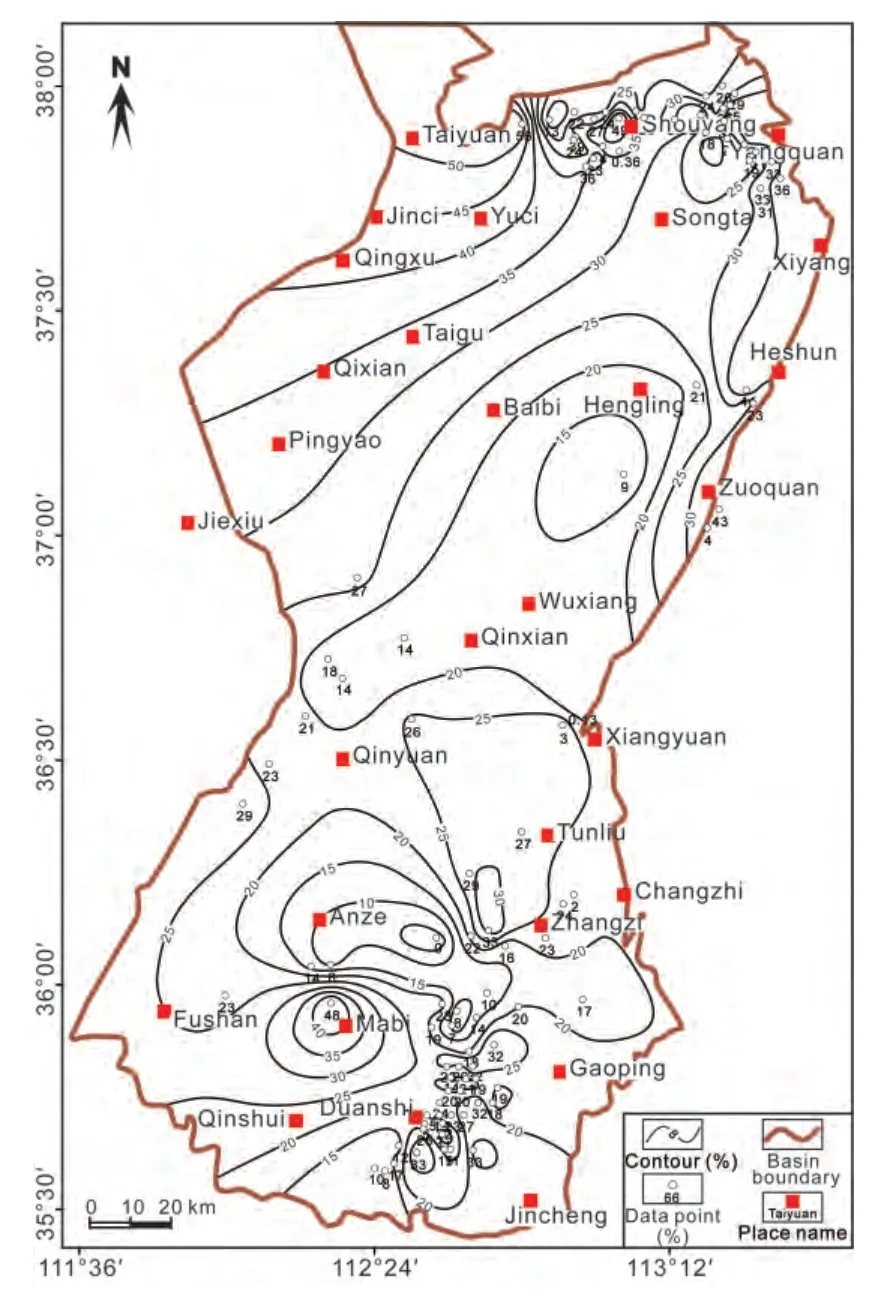
Figure 20 Contour map of percentage of sandstones in the Taiyuan Formation of the Qinshui Basin.
5.2.2 Palaeogeographic map of the Taiyuan Formation
Based on the above contour maps, such as the contours of S/M ratios, the thickness of limestones, and other individual lithological parameters, as well as on analysis of the sedimentary facies in the outcrop and borehole sections,a palaeogeographic map of the Taiyuan Formation was reconstructed (Fig. 22). It can be seen that the northern zone of the Qinshui Basin (Pingyao-Qixian-Taiyuan-Shouyang-Yangquan-Zuoquan area) was occupied by a lower delta plain environment with S/M ratios higher than 0.5, the Hengling-Wuxiang-Qinxian area was occupied by the delta front environment with S/M ratios lower than 0.5, the central part of the Qinshui Basin (Qinyuan-Tunliu-Zhangzi area) was developed as a tidal flat environment with S/M ratios higher than 0.5, the southern part (Qinshui-Mabi-Anze-Fushan area) was developed as a lagoonal environment with S/M ratios lower than 0.5, and the most southeastern corner (Gaoping-Jincheng area) was dominated by a carbonate platform environment with a limestone thickness of more than 20 m. The locally high S/M ratios (higher than 0.5) in the southeastern area represent a barrier bar environment (Fig. 21). As the limestones are mainly distributed in the southeastern part of the Qinshui Basin, it can be inferred that the transgression was from the southeastern direction, which was related to the regional transgression from the Huainan and Huaibei areas in the great northern China Basin (CNACG, 1997; Shaoet al., 2014). The sandstones gradually become thinner form north to south, indicating a northerly provenance from the regional Yinshan palaeocontinent (CNACG, 1997; Shaoet al., 2014).
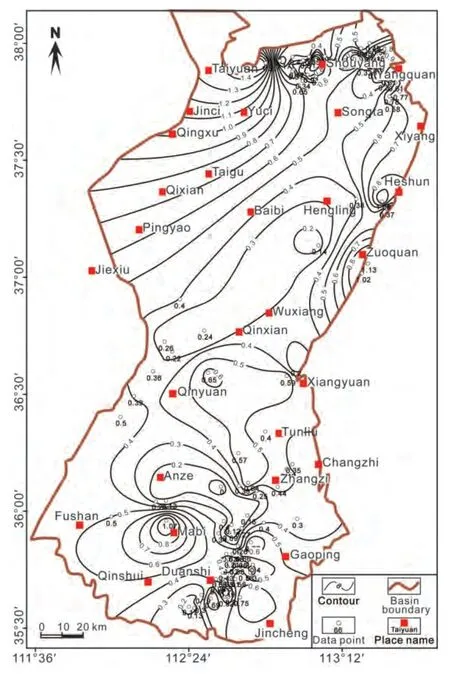
Figure 21 Contour map of the sandstone/mudstone ratio of the Taiyuan Formation in the Qinshui Basin.
5.3 Lithofacies palaeogeography of the Shanxi Formation
5.3.1 Lithofacies palaeogeography analysis of the Shanxi Formation
The Shanxi Formation in the Qinshui Basin lies below the Luotuobozi Sandstone of the overlying Xiashihezi Formation and extends to the bottom of the Beichagou Sandstone. This formation is composed of fine- to medium- to coarse-grained sandstone, siltstone, mudstone, and coal seams, with locally developed conglomerate and limestone.The Beichagou Sandstone (K7Sandstone), one of the marker beds, was developed at the bottom of this formation, and it is composed of medium- to coarse-grained sandstones and partially by conglomerates. Tabular and trough crossbedding and wedge-shaped cross-bedding were developed in this sandstone, with basal lenticular conglomerate lags containing mud pebbles and fossil wood. This sandstone represents an incised valley fill deposit formed during a regionally lowstand distributary channel incision (Shaoet al., 2008b). The deposits overlying the Beichagou Sandstone consist of fine-grained sandstone, siltstone, mudstone, and coal seams, representing a complex of an interdistributary bay environment in a lower delta plain setting. The fine- and medium-grained sandstones in several parts are moderatewell sorted with a low content of mud matrix, representing a mouth bar deposit of a delta front facies where sands had been repetitively winnowed by waves and tidal currents.
In selected boreholes, the total thickness of the Shanxi Formation varies between 20.2 m and 150.3 m, averaging 60 m, with the greatest thickness at the Qinxian area across the central part of the basin (Fig. 23). The total thickness of coal seams varies from 0.3 m to 10 m, averaging 4.6 m,with the greatest thickness at the Gaoping-Duanshi and Qinyuan areas in the southern Qinshui Basin (Fig. 24). The total thickness of sandstones varies between 0.6 m and 56.4 m, averaging 18 m, with the greatest thickness at the Qixian-Yuci-Songta area in the northern Qinshui Basin(Fig. 25). Percentages of sandstones range from 0% to 64%,averaging 29%, with the highest values at the Taiyuan-Shouyang-Yangquan area in the northern basin, followed by the Xiangyuan and Gaoping areas at the southern end of the basin (Fig. 26).
S/M ratios of the Shanxi Formation vary from 0 to 2.2,averaging 0.6, with the highest value at the Taiyuan-Shouyang-Yangquan, Xiangyuan, and Gaoping areas (Fig. 27),showing a similar distribution to the area with the highest percentage of sandstones. From the contours of the S/M ratios for the Shanxi Formation (Fig. 27), it can be seen that a sandstone-rich zone existed towards the north of the basin.The S/M ratios in this zone are generally higher than 0.5,except in a narrow belt along the Qinxian-Wuxiang area near Yangquan. In the central area of the Qinshui Basin,a sandstone-rich zone occurs near the Qinyuan-Xiangyuan area where the S/M ratios were mostly lower than 0.5. In contrast to the northern zone, the southern zone has generally lower S/M ratios, except in a narrow belt along the northwestern side of the Gaoping-Jincheng area.
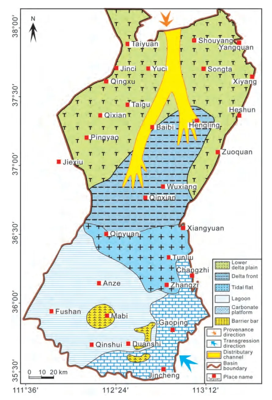
Figure 22 Lithofacies palaeogeography of the Taiyuan Formation in the Qinshui Basin.
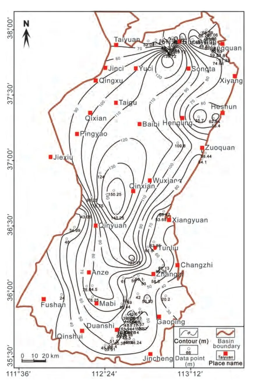
Figure 23 Isopach map showing the total thickness of the Shanxi Formation in the Qinshui Basin.
5.3.2 Palaeogeographic map of the Shanxi Formation
A palaeogeographic map of the Shanxi Formation was constructed mainly based on the contours of S/M ratios and combined with other single lithological parameters, as well as on sedimentary facies analysis of the outcrop and borehole sections (Fig. 28). During deposition, the northern sandstone-rich zone was dominated by an upper delta plain environment, where the S/M ratios were higher than 0.5.The central zone mainly developed as a lower delta plain environment, where the S/M ratios were lower than 0.5.The southern zone developed as a delta front environment,where the S/M ratios were less than 0.4. The relative enrichment of sandstones and mudstone in the northern and southern basins, respectively, indicates a northerly provenance, which is in accordance with the overall provenance of the northern Yinshan palaeocontinent, and a southeasterly transgression direction (CNACG, 1997).
5.4 Lithofacies palaeogeography of the Xiashihezi Formation
5.4.1 Lithofacies palaeogeography analysis of the Xiashihezi Formation
The Xiashihezi Formation in the Qinshui Basin is marked at the base by the bottom of the Luotuobozi Sandstone and at the top by the Taohua (mottled) Mudstone (Fig. 2). This formation is composed of fine- to medium-grained sandstones, siltstones, and sandy and mottled mudstones. The siltstones are gray to black gray, commonly contain mica as well as fossil plant fragments, and have ripple laminations. The fine-grained sandstones are light gray, moderately sorted, and show cross-bedding in the upward-fining successions. The sand grains are mainly quartz and feldspar with minor rock fragments with a siliceous cement. The mottled mudstone is typically developed at the top of the formation and is characterized by a mottled mixture of red and green colors.
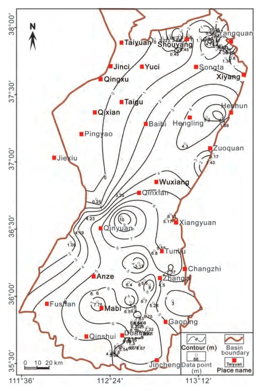
Figure 24 Isopach map of coal thickness of the Shanxi Formation in the Qinshui Basin.
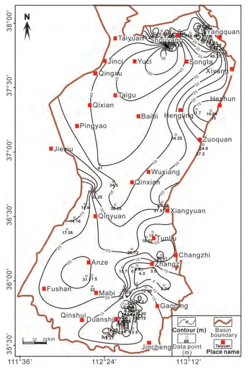
Figure 25 Isopach map showing the total thickness of sandstones of the Shanxi Formation in the Qinshui Basin.
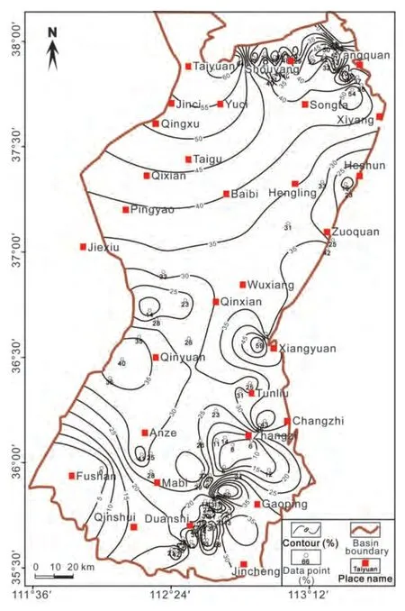
Figure 26 Isopach map showing the percentage of sandstones of the Shanxi Formation in the Qinshui Basin.
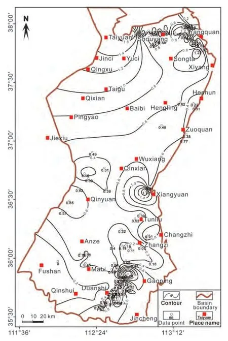
Figure 27 Isopach map of the sandstone/mudstone ratio of the Shanxi Formation in the Qinshui Basin.
In selected boreholes, the total thickness of the Xiashihezi Formation varies from 26.4 m to 277.5 m, averaging 85 m, and shows a declining trend from west to east, with the greatest thickness at the Mabi-Anze and Pingyao-Qixian areas along the western side of the basin. This indicates that the subsidence rate of the western part was higher than the eastern part during the deposition (Fig. 29). The total thickness of the sandstone varies between 3.5 m and 98.3 m, averaging 27.7 m, with the greatest thickness near the Shouyang, Pingyao-Qixian, Qinyuan, and Mabi-Anze areas. The percentages of sandstones vary between 2%and 94%, averaging 34.2%. Sandstones with relatively high percentage and thickness are also found in these areas. S/M ratios of the Xiashihezi Formation vary from 0.02 to 1.9,averaging 0.58. S/M ratios higher than 0.6 can define three sandstone-rich zones. The northern zone was small and only restricted to the Shouyang-Yangquan-Xiyang area,the central zones were relatively wider, and represented by the Qinyuan-Xiangyuan-Zuoquan area and the Duanshi-Gaoping-Jincheng areas (Fig. 30).
5.4.2 Palaeogeographic map of the Xiashihezi Formation
A palaeogeographic map of the Xiashihezi Formation was reconstructed on the basis of contours of S/M ratios and other lithological parameters as well as on a sedimentary facies analysis on the outcrop and borehole sections(Fig. 31). During deposition the area was mainly dominated by a fluvial channel environment, where the areas with S/M ratios higher than 0.6 were developed as fluvial channel zones, and other areas were mainly dominated by a flood basin environment with S/M ratios lower than 0.6. The fluvial channel zones developed in the northern part around the Shouyang-Yangquan area, the central part around the Zuoquan-Tunliu-Qinyuan-Qinxian area, and the southeastern part around the Mabi-Duanshi-Jincheng area. The flood basin was dominated by littoral and shallow lacustrine environments. A northerly provenance and a southeasterly transgression direction were established in accordance with the overall palaeogeography of the greater North China Basin during the Carboniferous and Permian (CNACG,1997; Shaoet al., 2014).
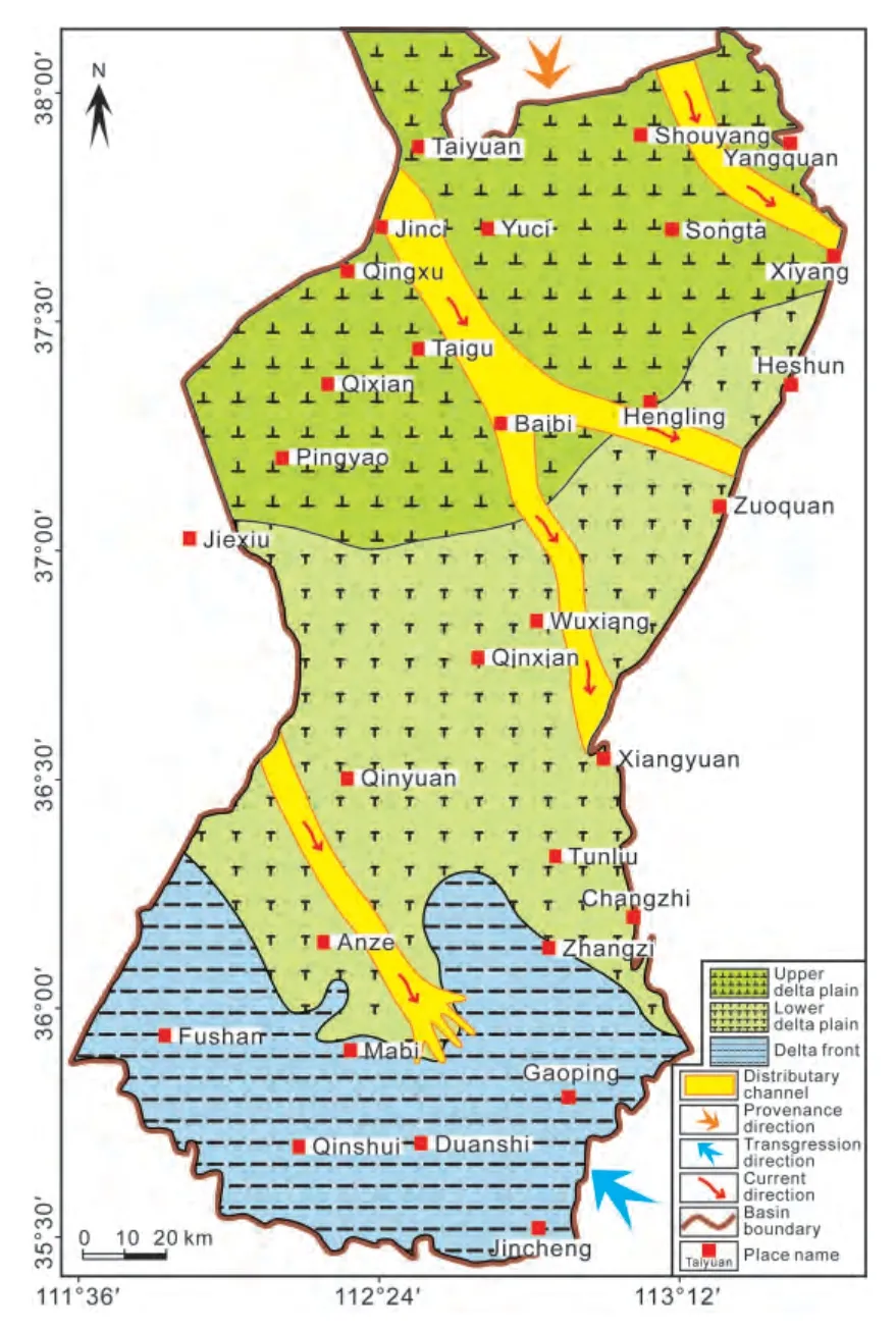
Figure 28 Lithofacies palaeogeography of the Shanxi Formation in the Qinshui Basin.
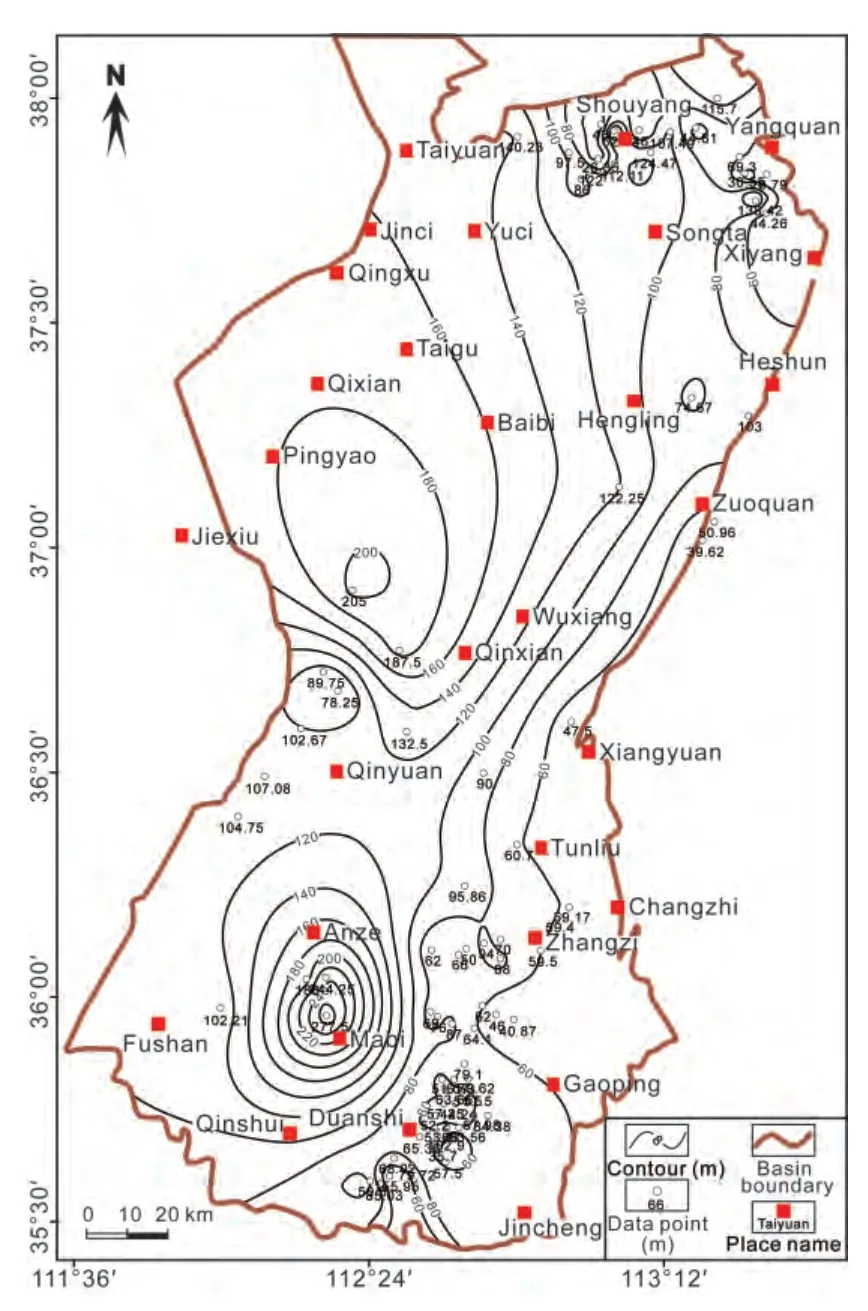
Figure 29 Isopach map showing the total thickness of the Xiashihezi Formation in the Qinshui Basin.
5.5 Lithofacies palaeogeography of the Shangshihezi Formation
5.5.1 Lithofacies palaeogeography analysis of the Shangshihezi Formation
The Xiashihezi Formation in the Qinshui Basin is marked at the base by the bottom of the Luotuobozi Sandstone and at the top by the Taohua (mottled) Mudstone.
The Shangshihezi Formation is marked at the base by the K8Sandstone (overlying the Taohua Mudstone) and at the top by the bottom of K13Sandstone. This formation is composed of red and purple-colored, interbedded sandstones and mudstones. According to its lithological characteristics, this formation can be subdivided into three parts. The lower part mainly consists of an intercalation of grayish green and red patchy mudstone and grayish white sandstone, with the grayish white, thick-bedded,coarse-grained feldspathic quartz sandstones occurring at the bottom. The middle part comprises grayish yellow and partly purple mudstone and sandstone intercalations,with massive, thick, grayish white sandy conglomerates and coarse-grained sandstones at its bottom. The upper part is mainly composed of purple mudstones, finegrained sandstones, and grayish yellow medium-grained sandstones, with grayish white pebbly sandstones at its bottom. The depositional environments of the Shangshihezi Formation were mainly braided and meandering fluvial environments.
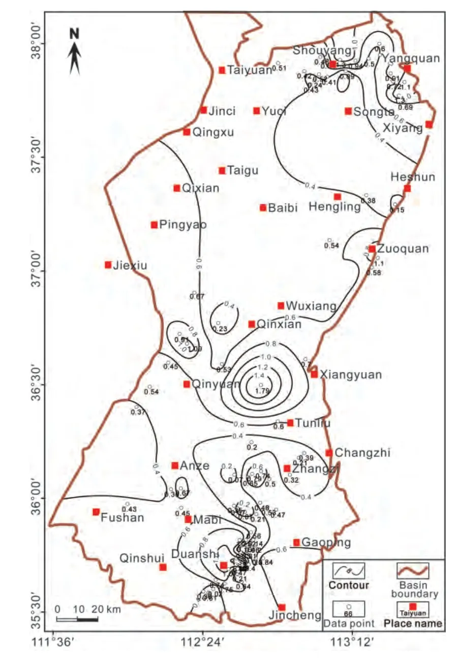
Figure 30 Isopach map of the sandstone/mudstone ratio of the Xiashihezi Formation in the Qinshui Basin.
In selected boreholes, the total thickness of the Shangshihezi Formation varies from 122.1 m to 740 m, averaging 385 m, with a southward thickening trend. The greatest thickness was found at the Yuci-Songta and Tunliu-Gaoping-Mabi areas (Fig. 32). The total thickness of the sandstones varies between 31 m and 376.2 m, averaging 124 m, with the greatest thickness at the Gaoping area in the south of the basin. The percentages of sandstones vary between 11% and 65%, averaging 32%, with the highest values at the Shouyang-Songta-Xiyang area north of the basin and the Gaoping-Jincheng area southeast of the basin. S/M ratios in the Shouyang-Yangquan-Xiyang and the Changzhi-Gaoping-Jincheng areas vary between 0.12 and 1.86, averaging 0.5, and there are two sandstonerich zones in the basin with S/M ratios higher than 0.6(Fig. 33).
5.5.2 Palaeogeographic map of the Shangshihezi Formation
A palaeogeographic map of the Shangshihezi Formation was reconstructed on the basis of contours of S/M ratios and other single lithological parameters as well as on a sedimentary facies analysis of outcrop and borehole sections (Fig. 34). During deposition the area was mainly dominated by fluvial channel environments, including fluvial channel zones with S/M ratios higher than 0.6 and flood basin (mainly lacustrine) zones with S/M ratios lower than 0.6. The fluvial channel zones were mainly located in the Qingxu-Hengling-Zuoquan area in the northeast and the Changzhi-Gaoping-Jincheng area in the southeast.A northerly provenance is inferred in accordance with the overall palaeogeography of the greater North China Basin during the Carboniferous and Permian (CNACG, 1997; Shaoet al., 2014).
Figure 31 Lithofacies palaeogeography of the Xiashihezi Formation in the Qinshui Basin.
5.6 Lithofacies palaeogeography of the Shiqianfeng Formation
5.6.1 Lithofacies palaeogeography analysis of the Shiqianfeng Formation
The Shiqianfeng Formation is marked at the base by the bottom of the K13Sandstone and at the top by the bottom of the Liujiagou Sandstone (K14Sandstone). This formation contains purple mudstone with calcareous concretions,interbedded yellowish green medium-grained sandstone,purple mudstone, and thick-bedded medium- to coarsegrained sandstone. This formation was mainly deposited in a fluvial lacustrine environment (CNACG, 1997).
Because boreholes in the Shiqianfeng Formation are scarce, the analysis was based on only 15 selected boreholes. The total thickness of the Shiqianfeng Formation varies from 83 m to 286 m, averaging 186 m, with a southward thickening trend, and the greatest thickness is in the Yuci-Songta-Mabi area in the north (Fig. 35). The total thickness of the sandstones varies between 12 m and 111.9 m, averaging 61m, with the greatest thickness in the Mabi-Duanshi-Gaoping-Zhangzi area. The percentages of sandstones vary between 8% and 70%, averaging 39.8%.The areas with the highest percentage of sandstones occur in the Changzhi-Zhangzi-Mabi area in the southeast,as well as in the northeastern part of the Shouyang-Heshun area in the north. S/M ratios of the Shiqianfeng Formation vary between 0.09 and 2.37, averaging 0.86, and two sandstone-rich zones with S/M ratios higher than 0.8 occur in the Shouyang-Heshun area in the northeastern part and the Changzhi-Zhangzi-Mabi area in the southeastern part(Fig. 36).
5.6.2 Palaeogeographic map of the Shiqianfeng Formation
A palaeogeographic map of the Shiqianfeng Formation was reconstructed on the basis of contours of the S/M ratios and other lithological parameters, as well as on a sedimentary facies analysis in outcrop and borehole sections (Fig.37). During deposition, the area was mainly dominated by fluvial channel to flood basin (mainly lacustrine) environments. Areas with S/M ratios higher than 0.6 represent fluvial channel zones, whereas areas with S/M ratios lower than 0.6 consist mainly of inter-fluvial lacustrine environments. The fluvial channel zones developed to the east of the Shouyang-Songta-Hengling-Wuxiang-Tunliu area and to the north of the Fushan-Mabi-Changzhi area (Fig. 37).These channel zones have a distribution that is almost the same as that of the Shangshihezi Formation. Therefore, the provenance is interpreted to be similar to that of the regional Yinshan palaeocontinent to the north.
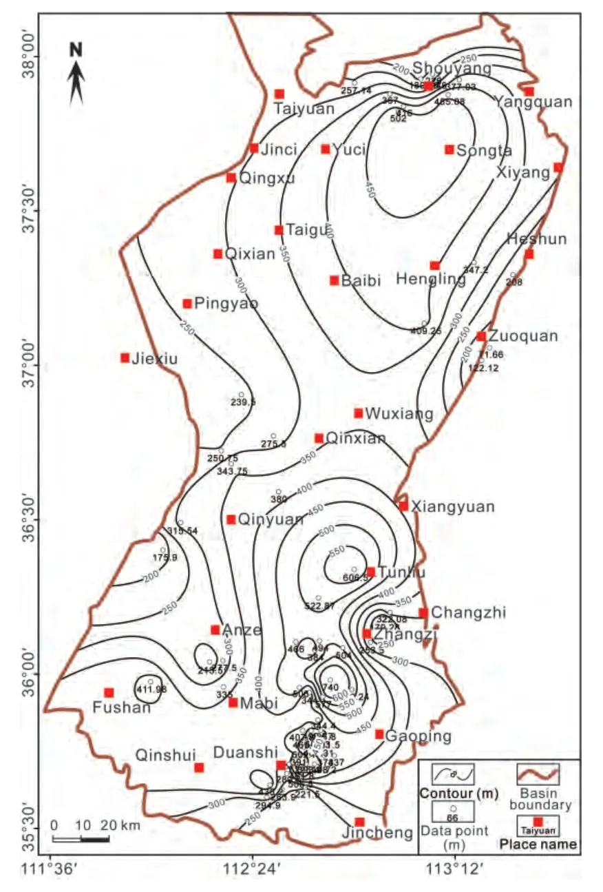
Figure 32 Isopach map showing the total thickness of the Shangshihezi Formation in the Qinshui Basin.
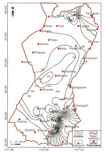
Figure 33 Isopach map of the sandstone/mudstone ratio of the Shangshihezi Formation in the Qinshui Basin.
5.7 Palaeogeographic evolution and fossil energy resources
It can be concluded from the palaeogeographical analyses that the Qinshui Basin represents tidal flat-lagoon and carbonate platform environments in the Benxi and Taiyuan Formations, fluvial-dominated delta environments in the Shanxi Formation, and fluvial and flood basin (back-lake)environments in the Xiashihezi, Shangshihezi, and Shiqianfeng Formations. The palaeogeographical patterns reveal an overall upward-shallowing succession where a marine transgression switched from the northeast (Benxi and basal Taiyuan formations) to the southeast (Taiyuan, Shanxi, Xiashihezi, Shangshihezi, and Shiqianfeng Formations).
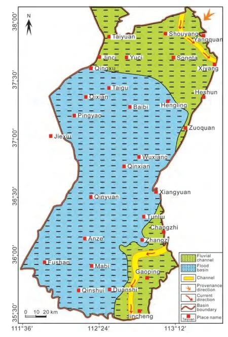
Figure 34 Lithofacies palaeogeography of the Shangshihezi Formation in the Qinshui Basin.
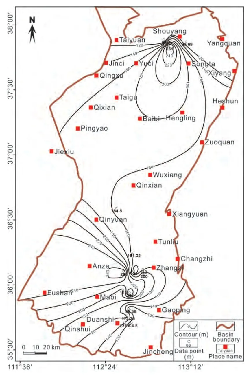
Figure 35 Isopach map showing the total thickness of the Shiqianfeng Formation in the Qinshui Basin.
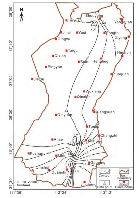
Figure 36 Isopach map of the sandstone/mudstone ratio of the Shiqianfeng Formation in the Qinshui Basin
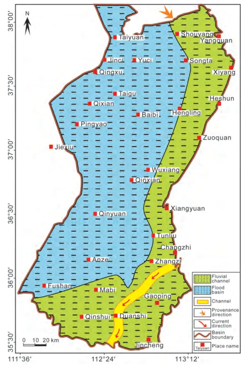
Figure 37 Lithofacies palaeogeography of the Shiqianfeng Formation in the Qinshui Basin.
The Benxi, Taiyuan, and Shanxi Formations are dominated by dark-colored carbonaceous mudstones, gray siltstones, gray limestones, bauxitic mudstones, and coals,which are typical indicators of humid and warm climatic conditions. In contrast, red-colored mudstones commonly occur in the Xiashihezi, Shangshihezi, and Shiqianfeng Formations, representing semi-arid to arid climates. It is obvious that the palaeoclimates during the Carboniferous and Permian varied from humid to semi-arid and arid conditions. The warm and humid climates during the Late Carboniferous and Early-Middle Permian were favorable to the development of coal-forming mires and accumulation of thick coal seams. These coal seams not only provide abundant coal resources but also abundant coalbed methane resources. The dark-colored mudstones in these formations can be potential targets for shale gas exploration(Guet al., 2011). Sandstones in the entire Carboniferous and Permian successions can be ideal reservoirs for natural gas, providing potential exploration sites for tight sandstone gas.
6 Conclusions
There were five major depositional systems in the Qinshui Basin during the Carboniferous and Permian, including fluvial depositional, delta, lacustrine, tidal flat-lagoon, and carbonate platform systems. A total of 22 lithofacies have been recognized in the coal-bearing successions. Despite the fact that coal-forming swamps could develop in almost every depositional system within the basin, the inter-distributary bay of the delta system and the tidal flat-lagoon system provided favorable environments for coal formation.
Lithofacies palaeogeographic maps were reconstructed on the basis of a number of contour maps and sedimentary facies analyses. Palaeogeographical units developed during the Carboniferous and Permian include flood basin, fluvial channel, upper delta plain, lower delta plain, delta front,lacustrine, tidal flat, lagoon, barrier bar, and carbonate platform facies. During the Late Carboniferous (Benxi Formation) and late Late Carboniferous to early Early Permian(Taiyuan Formation), the Qinshui Basin area experienced cyclic changes from carbonate platform to lagoon-delta environments, forming characteristic coal-bearing limestonesiliciclastic successions. During the late Early Permian(Shanxi Formation), a delta system was developed which was dominated by a lower delta plain environment.
During the early Middle Permian (Xiashihezi Formation)to the late Middle to early Late Permian (Shangshihezi Formation) and late Late Permian (Shiqianfeng Formation),the Qinshui Basin area was dominated by a fluvial setting and an arid to semi-arid palaeoclimate, which is indicated by the intercalation of thick sandstone beds and thick redcolored mudstones. The sedimentary provenance of the Basin during the Late Carboniferous was from the east and northeast, while during the Permian it was mainly from the regional Yinshan palaeocontinent to the north.
From this study, it can be postulated that palaeoenvironments suitable for substantial and prolonged coal accumulation occurred in the entire Basin, but different developments existed in the Taiyuan and Shanxi Formations.The No. 15 coal of the Taiyuan Formation formed in tidallagoon settings and developed thicker towards the northern part of the basin. In contrast, the No. 3 coal of the Shanxi Formation formed in a fluvial-delta setting, and developed thicker towards the southern part of the basin. The No. 15 and No. 3 coals form sound reservoirs for coalbed methane exploration and development, and the dark-colored mudstones and silty mudstones can be potential targets for shale gas exploration. The sandstone beds in all these formations may be potential sites for the exploration of tight sandstone gas in the future.
Acknowledgements
This research was supported by the National Natural Science Foundation of China (No. 41572090, No. 41472131),and the Major National S&T (Science and Technology) Program of China (2016ZX05041004-003). We would like to thank Professor Peng-Fei Zhang and Professor Huan-Jie Liu for their encouragement. We also thank Professor Zeng-Zhao Feng and Professor A. J. (Tom) van Loon for their constructive comments to improve the manuscript.
1. Chen, G., Liu, L. Y., 1998. The analysis on the trap conditions of the Paleozoic natural gas in the Qinshui Basin.Northwest‑ern Geology, 19(4), 34-38 (in Chinese).
2. Cheng, B. Z., 1992. Late Paleozoic Sedimentary Environments and Coal Accumulation in Shanxi, China. Shanxi Science and Technology Press, Taiyuan, Shanxi (in Chinese).
3. CNACG (China National Administration of Coal Geology),1997. Late Paleozoic Coal Geology of North China Platform.Shanxi Science and Technology Press, Taiyuan, Shanxi (in Chinese with English Abstract).
4. CNACG (China National Administration of Coal Geology),1998. Coalbed Methane Resources of China. China University of Mining and Technology Press, Xuzhou, Jiangsu (in Chinese with English Abstract).
5. Dai, J. X., Qi, H. F., 1981. Evaluation of natural gas prospect in Qinshui Basin in the light of coal-derived gas.Petroleum Exploration and Development, (6), 19-33 (in Chinese).
6. Fang, C., Gu, J. Y., Zhang, B., Zhang, W. L., 2013. The parameters analysis of shale gas reserves estimation in paralic facies coal-bearing basin — Taking Qinshui Basin as an example.Geology of Chemical Minerals, 35(3), 169-174 (in Chinese with English abstract).
7. Feng, Z. Z., 1992. Single factor analysis and comprehensive mapping method — Methodology of lithofacies paleogeography.Acta Sedimentologica Sinica, 10(3), 70-77 (in Chinese with English abstract).
8. Feng, Z. Z., 2004. Single factor analysis and multifactor comprehensive mapping method — Reconstruction of quantitative lithofacies palaeogeography.Journal of Palaeogeography(Chinese Edition), 6(1), 3-19 (in Chinese with English abstract).
9. Feng, Z. Z., Zheng, X. J., Bao, Z. D., Jin, Z. K., Wu, S. H., He,Y. B., Peng, Y. M., Yang, Y. Q., Zhang, J. Q., Zhang, Y. S., 2014.Quantitative lithofacies palaeogeography.Journal of Palaeo‑geography, 3(1), 1-34.
10. Ferm, J. C., Staub, J. R., 1984. Depositional Controls of Mineable Coal Bodies, in: Rahmani, R. A., Flores, R. M. (Eds.),Sedimentology of Coal and Coal-bearing Sequences. IAS Special Publication, 7. Blackwell Scientific Publications, Oxford,pp. 273-289.
11. Fielding, C. R., 1984. A coal depositional model for the Durham Coal Measures of NE England.Journal of the Geological Society, 141(5), 919-931.
12. Ge, B. X., Yin, G. X., Li, C. S., 1985. A preliminary study on sedimentary environments and law of coal-bearing formation in Yangquan, Shanxi.Acta Sedimentologica Sinica, 3(3), 33-44 (in Chinese with English abstract).
13. Gu, J. Y., Ye, J. P., Fang, C., Shao, L. Y., 2011. Prospects of shale gas resources in Qinshui Basin, in: Ye, J. P., Fu, X.K., Li, W. Z., (Eds.), Pr—oceedings of the 2011 Coalbed Methane (CBM) Symposium The Progress of CBM Technology in China. Geological Publishing House, Beijing, pp. 455-461 (in Chinese with English abstract).
14. Guion, P. D., Fulton, I. M., Jones, N. S., 1995. Sedimentary facies of the coal-bearing Westphalian A and B north of the Wales-Brabant High, in: Whateley, M. K. G., Spears, D. A.(Eds.), European Coal Geology.Geological Society,London,Special Publications, 82, pp. 45-78.
15. Han, D. X., Yang, Q., 1980. Coalfield Geology of China (Volume 2). China Coal Industry Publishing House, Beijing (in Chinese).
16. Horne, J. C., Ferm, J. C., Caruccio, F. T., Baganz, B. P., 1978.Depositional models in coal exploration and mine planning in Appalachian region.AAPG bulletin, 62(12), 2379-2411.
17. Hsü, K. J., 1989. Origin of sedimentary basins of China, in:Zhu, X. (Ed.), Chinese Sedimentary Basins. Elsevier, Amsterdam, pp. 207-227.
18. Hu, B., Hu, L., Song, H. B., Yang, L. C., 2013. Ichnoassemblages and their sedimentary environments in limestone of the Upper Carboniferous-Lower Permian Taiyuan Formation,southeastern Shanxi Province.Journal of Palaeogeography(Chinese Edition), 15(6), 809-818 (in Chinese with English abstract).
19. Huang, Z. M., Zhang, H. S., Xu, J. G., Ge, B. X., Liu, Z. F.,1989. The sedimentary environment and coal accumulation characteristics of the coal bearing series in Shouyang coal field, East Shanxi.Acta Sedimentologica Sinica, 7(1), 91-99(in Chinese with English abstract).
20. IGE-CCMRI/SPCEC (Institute of Geological Exploration CCMRI and Shanxi Provincial Coal Exploration Company), 1987. Sedimentary Environments of Taiyuan Xishan Coal Basin. China Coal Industry Publishing House, Beijing (in Chinese).
21. Jin, Z. K., Su, N. N., Wang, C. S., 2008. Controlling factors of reservoir of coal rocks in Carboniferous-Permian, North China.Acta Geologica Sinica, 82(10), 1323-1329 (in Chinese with English abstract).
22. Kong, X. Z., Xu, H. L., Li, R. L., Chang, J. L., Liu, L. J., Zhao,X. P., Zhang, L. X., Liao, Z. T., Zhu, H. C., 1996. Late Paleozoic Coal-Bearing Strata and Biota in Shanxi, China. Shanxi Science and Technology Press, Taiyuan (in Chinese).
23. Liu, H. J., Qin, Y., Sang, S. X., 1998. Geology of Coalbed Methane in Southern Shanxi, China. China University of Mining and Technology Press, Xuzhou, Jiangsu (in Chinese).
24. Marchioni, D., Gibling, M., Kalkreuth, W., 1996. Petrography and depositional environment of coal seams in the Carboniferous Morien Group, Sydney Coalfield, Nova Scotia.Canadian Journal of Earth Sciences, 33(6), 863-874.
25. Qin, Y., Song, D. Y., Wang, C., 1997. Coalification of the Upper Paleozoic coal and its control to the generation and preservation of coalbed methane in the southern Shanxi.Journal of China Coal Society, 22(3), 230-235 (in Chinese with English abstract).
26. Qin, Y., Liang, J. S., Shen, J., Liu, Y. H., Wang, C. W., 2014.Gas logging shows and gas reservoir types in tight sandstones and shales from southern Qinshui Basin.Journal of China Coal Society, 39(8), 1559-1565 (in Chinese with English abstract).
27. Shao, L. Y., Zhang, P. F., Hilton, J., Gayer, R., Wang, Y. B.,Zhao, C. Y., Luo, Z., 2003. Paleoenvironments and paleogeography of the Lower and lower Middle Jurassic coal measures in the Turpan-Hami oil-prone coal basin, northwestern China.AAPG Bulletin, 87(2), 335-355.
28. Shao, L. Y., Xiao, Z. H., Lu, J., He, Z. P., Wang, H., Zhang,P. F., 2007. Permo-Carboniferous coal measures in the Qinshui basin: Lithofacies paleogeography and its control on coal accumulation.Frontiers of Earth Science in China, 1(1), 106-115.
29. Shao, L. Y., Lu, J., Wang, H., Zhang, P. F., Han, D. X., 2008a.Advances in sedimentology and sequence stratigraphy of paralic coal measures.Journal of Palaeogeography(Chinese Edi‑tion), 10(6), 561-570 (in Chinese with English abstract).
30. Shao, L. Y., Xiao, Z. H., Wang, H., Lu, J., Zhou, J., 2008b.Permo-Carboniferous coal measures in the Qinshui Basin:High-resolution sequence stratigraphy and coal accumulating models.Chinese Journal of Geology, 43(4), 777-791 (in Chinese with English abstract).
31. Shao, L. Y., Lu, J., Wang, H., Zhang, P. F., 2009. Developments of coal measures sequence stratigraphy in China.Acta Sedi‑mentologica Sinica, 27(5), 904-914 (in Chinese with English abstract).
32. Shao, L. Y., Dong, D. X., Li, M. P., Wang, H. S., Wang, D. D.,Lu, J., Zheng, M. Q., Cheng, A. G., 2014. Sequence-paleogeography and coal accumulation of the Carboniferous-Permian in the North China Basin.Journal of China Coal Society,39(8), 1725-1734 (in Chinese with English abstract).
33. Su, X. B., Lin, X. Y., Liu, S. B., Zhao, M. J., Song, Y., 2005. Geology of coalbed methane reservoirs in the Southeast Qinshui Basin of China.International Journal of Coal Geology, 62(4),197-210.
34. Sun, F. J., Zhao, Q. B., Deng, P., 1998. The main factors affecting coalbed methane exploration of anthracite area in China.Petroleum Exploration and Development, 25(1), 32-34 (in Chinese with English abstract).
35. Wei, C. T., Qin, Y., Fu, X. H., Jiang, B., Li, G. Z., Song, D. Y.,Jiao, S. H., 2002. Simulation of history of CBM concentrationdissipation in middle southern Qinshui Basin.Journal of China University of Mining and Technology, 31(2), 146-150 (in Chinese with English abstract).
36. Ye, J. P., Wu, Q., Ye, G. J., Chen, C. L., Yue, W., Li, H. Z.,Zhai, Z. R., 2002. Study on the coalbed methane reservoirforming dynamic mechanism in the southern Qinshui Basin,Shanxi.Geological Review, 48(3), 319-323 (in Chinese with English abstract).
37. Zhang, J. B., Wang, H. Y., 1999. The Prediction of Favorable Blocks of Coalbed Methane in the Qinshui Basin of the Shanxi Province. China University of Mining and Technology Press,Xuzhou, Jiangsu (in Chinese).
38. Zhang, P. F., Peng, S. P., Shao, L. Y., Liu, Q. F., Qu, Z., Ma,X. X., Hu, S. R., Yang, B. C., 1993. Sedimentological Analysis of the Coal-Bearing Sequence. China Coal Industry Publishing House, Beijing (in Chinese).
39. Zhang, P. F., Shao, L. Y., Dai, S. F., 2001. Discussions on the transgression model of the Late Paleozoic in the North China Platform.Journal of Palaeogeography(Chinese Edition),3(1), 15-24 (in Chinese with English abstract).
40. Zhang, X. M., Zhuang, J., Zhang, S. A., 2002. Coalbed Methane Geology and Resource Evaluation in China. Science Press,Beijing (in Chinese with English abstract).