西湖东岸城市景观规划
————西湖申遗之城市景观提升工程
2021-10-27王建国,杨俊宴,陈宇等
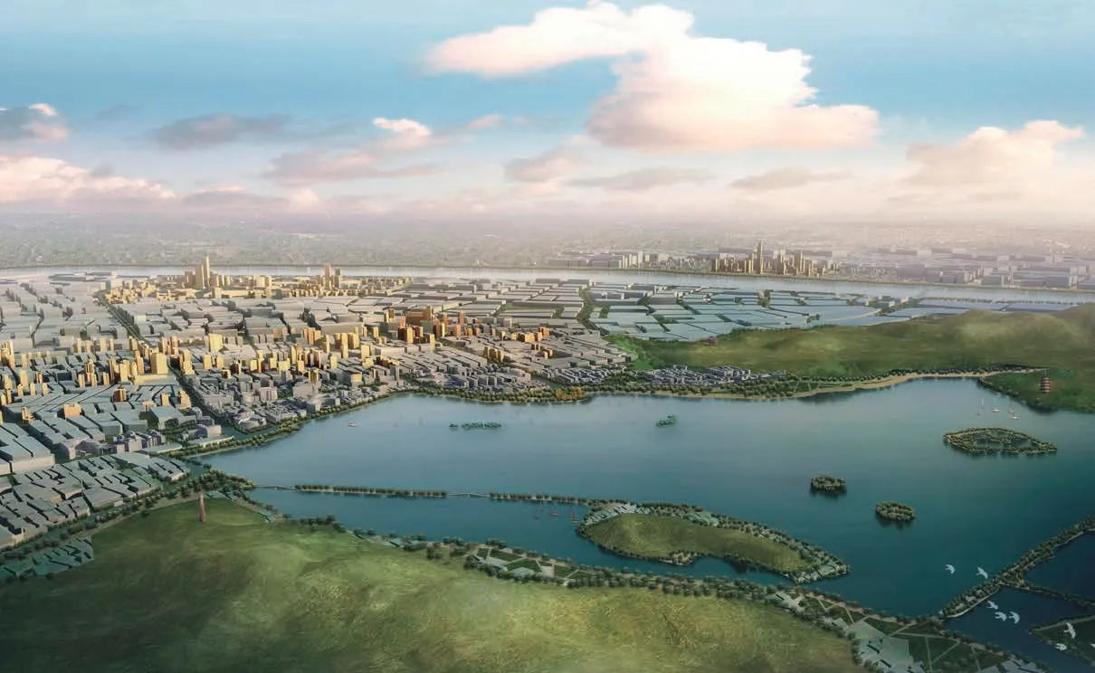
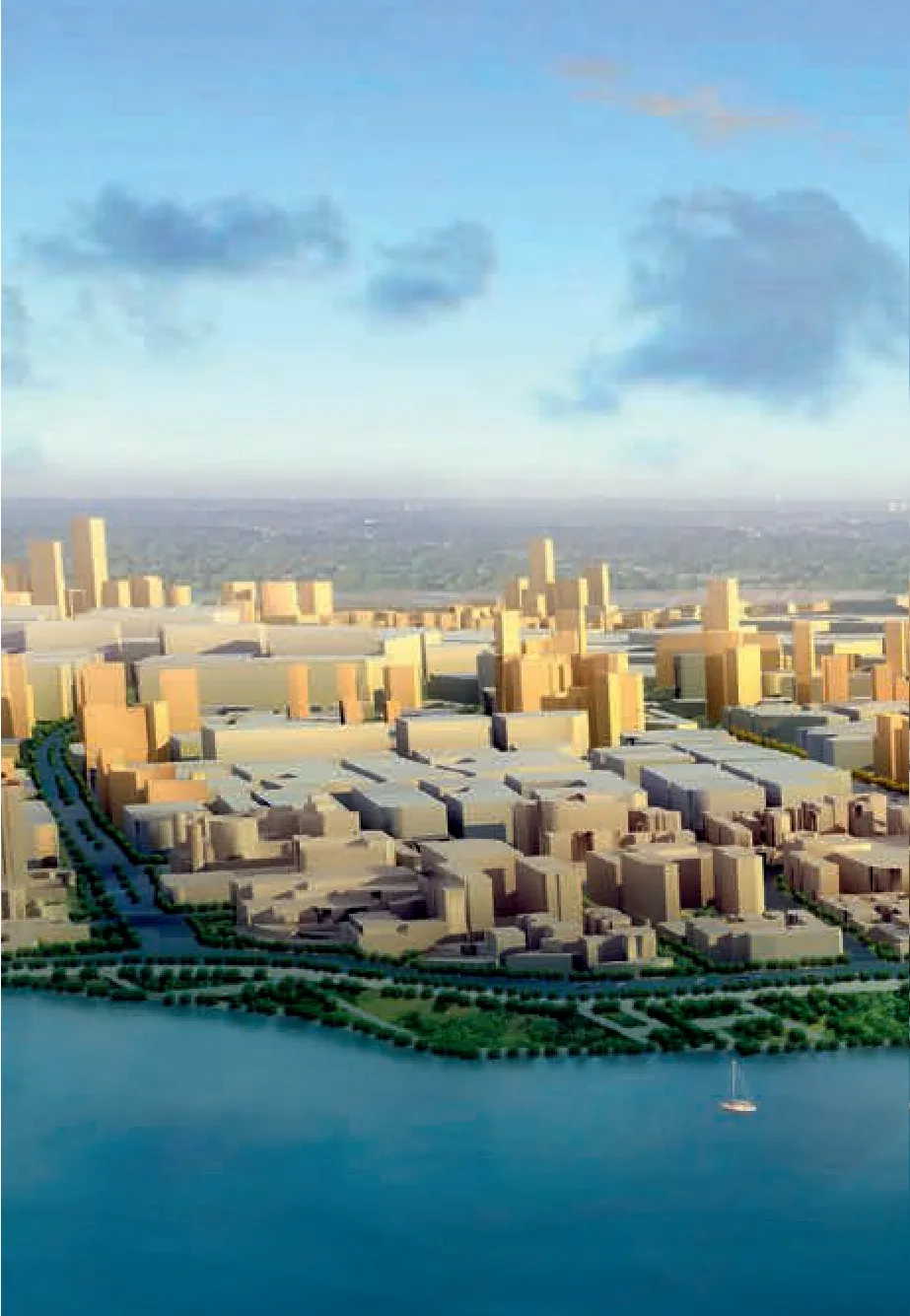
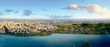
1 鸟瞰/Aerial view
西湖是中国传统山水园林中,历史悠久、文化内涵极为丰富的案例。本项目即是在西湖申报世界文化遗产的背景下,针对其景观提升展开的研究。
规划设计首先对西湖形成的自然历史和人文历史进行了梳理,进而廓清了西湖景观的价值和国内外具有广泛影响力的原因。规划设计成功创制并实践了基于GPS和GIS技术研究西湖随机视点分布规律的方法,同时还引入了“空气能见度”与景观观赏关系的研究,为西湖景观环境的提升和整治提供了关键科学依据。
规划设计以“疏解老城、城湖交融、山水入城”为理念,综合运用基于城市设计的大尺度空间形态控制理论、景观视觉评价理论和城市中心体系发展理论,分析了城市未来的高度形态分布,寻求西湖东岸城市景观控制的不同途径,提出“二核四辅”的高层分布、“山水绿脉”的景观轴线、“赏游合一”的观景游线和“秀隐谐巧”的建筑风貌四方面的综合景观提升策略。□
项目信息/Credits and Data
设计团队/Design Team: 王建国,杨俊宴,陈宇,徐宁等/WANG Jianguo, YANG Junyan, CHEN Yu, XU Ning, et al.
项目规模/Scale: 45 km2
设计时间/Design Period: 2008-2009
West Lake is a perfect example of traditional Chinese landscape gardens boasting a long history and abundant culture. This project aimed at upgrading the landscape of West Lake against the background of applying for the World Cultural Heritage Site.
The planning and design began with an overview of the natural and human history of the formation of the West Lake, to develop a clear idea of its scenic value and the reasons behind its extensive influence both at home and abroad. The project succeeded in creating and practicing the GPS- and GIS-based approaches in researching the distribution pattern of random vantage points and embarked on the study of relationships between"atmospheric visibility" and view admiring, thus providing key scientific data for the landscape renovating and upgrading of the West Lake.
The planning and design process, guided by the philosophy of "alleviating the old part of the city, integrating the city and the lake and creating a city with natural landscape", applies the theories of morphological control for large-scale spaces,visual landscape evaluation and urban centre system development that based on urban design in a comprehensive way. It conducts an analysis of the morphological distribution of heights of a city in the future in order to come up with different approaches of urban landscape control over the east bank of the West Lake. A height distribution of "two cores with four auxiliaries", a landscape axis of "landscaped green vein", tourist routes featuring an "integration of sightseeing and travelling", and an architectural style accentuating the "beautiful, obscure,harmonious and intricate" features of buildings are proposed as comprehensive strategies of upgrading the landscape.□

2.3 观景点的选取和等视线的确定/Selection of scenic spots and determination of equal sight line
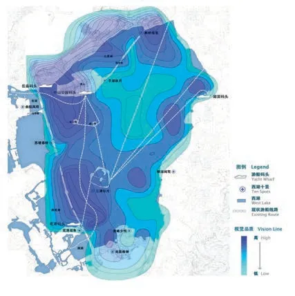
4 现状西湖游船路线与景观等视线叠合/Current superimposition of cruise line and equal sight line
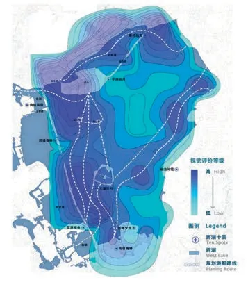
5 规划西湖游船路线与景观等视线叠合/Planned superimposition of cruise line and equal sight line

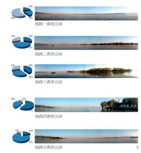
6 环湖景观立面/Elevation around West Lake
7.8 西湖景观与湖面游线的观景关系/Relationship between landscape and tour line
12 鸟瞰/Aerial view
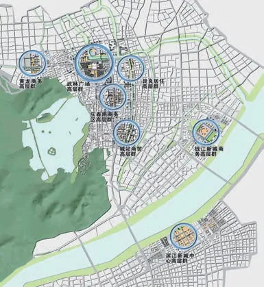
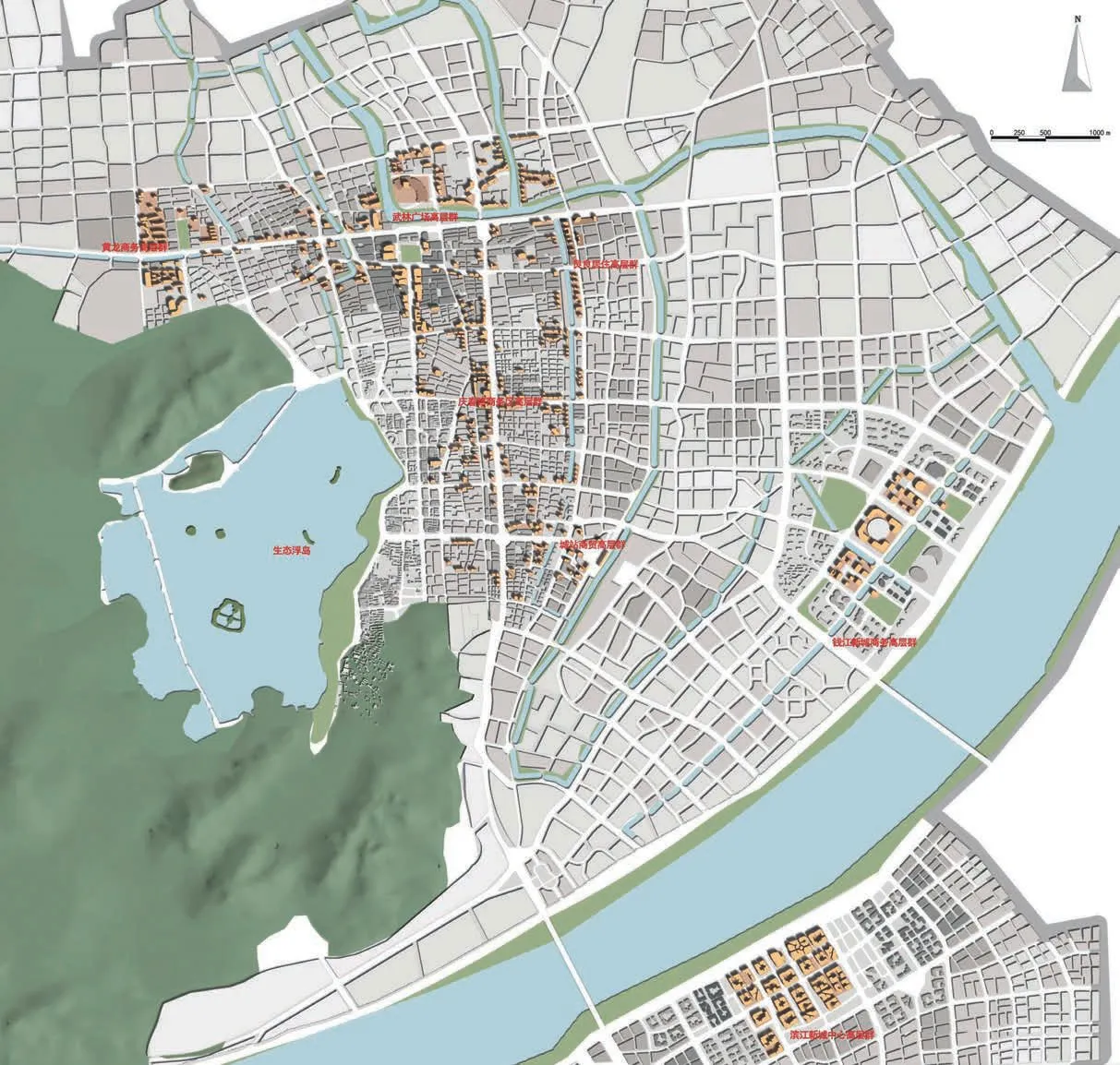
9 高层分布体系/High buildings distribution
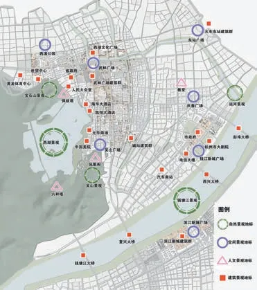
10 景观地标分布体系/Landmark distribution
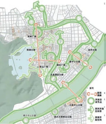
11 开放空间体系/Open space
专家评审会意见
该方案分为“研究篇、规划篇”两部分,通过“湖、城、人”要素及对三者关系的分析,探讨西湖景观特征、西湖与城市关系以及与游人观赏行为的关系,提出9个问题,并在此基础上构建数字化平台,分析城市未来最优高度形态,寻求东岸城市景观控制的途径,最终提出4个方面的景观提升科学对策。
该方案属方法论研究,提出“湖、城、人”理念,通过西湖“9问”透析历史与现状,提出应对措施,规划理论创新、技术方法创新、景观控制手段创新;提出了对近、中、远景观的改造理论,而且分别制定了前期、中期、远期景观控制模式,有较强的针对性,目标较明确。
Jury's Comments
The planning consists of two parts, "Research Section" and "Planning Section". According to the analysis on the three elements of "Lake, City, and Human" and the relationship between the three, it explored and investigated the landscape characteristics of the West Lake, the relationship between the West Lake and the city, as well as the relationship to the viewing behaviour of visitors, and raised nine major issues. On that basis, it built a digital platform, analysed the optimal height of the city in the future, sought a way to control the urban area landscape on the east bank, and finally put forward scientific measures for the improvement of the landscape from four major levels.
As a methodological research, the planning put forward the concept of integrating "Lake, City, and Human", analysed the history and current situation through the "Nine Issues" of West Lake, proposed measures, and planned theoretical innovation, technological method innovation, and landscape control method innovation. By proposing the theory of transformation of the short-distance, middle-distance,and long-distance landscapes, it formulated the pre-, mid-, and long-term landscape control modes respectively, showing strong pertinence and clear goals.
13 总平面/General layout
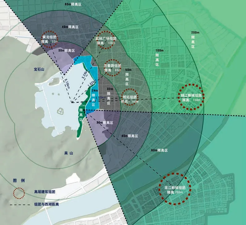
14 城区建筑高度空间景观安全格局管控/Security control of building height

15 轮廓线显现度分布/Contour line

16 近景中景远景分布/Vision range
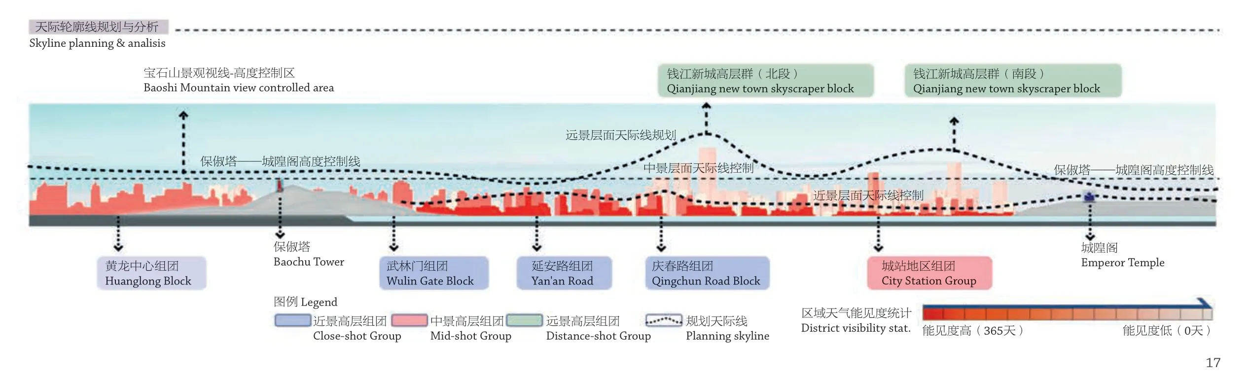
17 规划天际线与天气能见度统计/Skyline planning and weather visibility statistics
