夜光卫星遥感对城市夜间霾的监测识别与研究
2021-10-18李伟陈朝霞夏志业
李伟 陈朝霞 夏志业


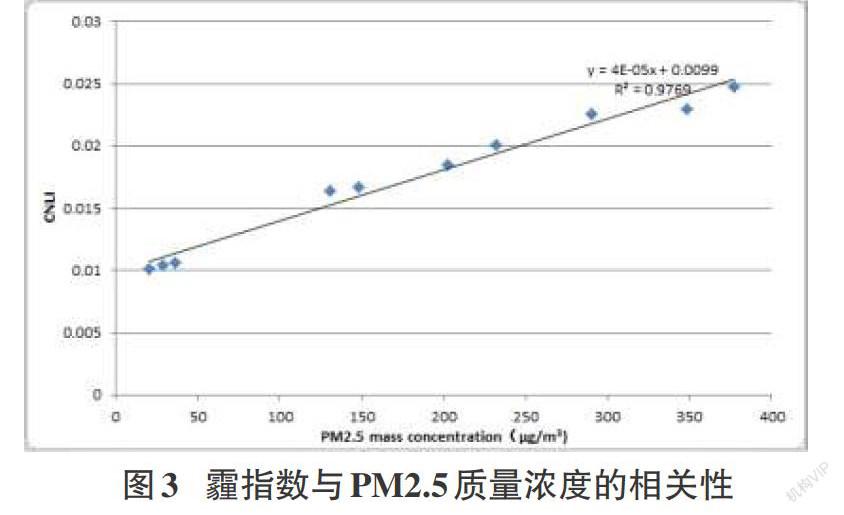
摘要:随着我国经济社会快速发展及城市化进程加快,大气污染物排放量增加,导致霾现象频发。目前对日间霾的研究较多,而对夜间霾的研究与监测等则很少,夜光卫星遥感为夜间霾的大范围高分辨率研究提供了新的方法。本文以北京2016年12月21日的一次夜间强霾为例,基于VIIRS DNB夜光卫星数据,构建了夜光霾指数模型,对霾变化过程及相关特征进行了分析。并与地基实测PM2.5质量浓度进行了对比分析,验证了算法精度,相关性R2达到了0.9769。研究结果表明,建立的夜光霾指数能较好表征夜间霾颗粒物特征及霾动态变化,为夜间霾污染治理及研究提供了科学支撑。
关键词:霾识别;夜光卫星;霾指数;PM2.5质量浓度
中图分类号:TP18 文献标识码:A
文章编号:1009-3044(2021)26-0091-03
开放科学(资源服务)标识码(OSID):
Identification of Urban Haze at Night Based on Nighttime Remote Sensing
LI Wei1,CHEN Zhao-xia1,XIA Zhi-ye2*
(1.Guangzhou Urban Planning & Design Survey Research Institute, Guangzhou 510060, China; 2.College of Resources and Environment, Chengdu University of Information Technology, Chengdu 610225, China)
Abstract:With the rapid development of China's economy and society and the acceleration of urbanization, the emission of air pollutants increase, resulting in haze frequently. At present, there are many researches on daytime haze, but few researches and monitoring on nighttime haze. Nighttime satellite remote sensing provides a new method for large-scale and high-resolution research on nighttime haze. Based on the data of VIIRS DNB nighttime satellite data, haze index model CNLI for nighttime is constructed to analyze the haze variation process and related characteristics. Compared with the measured PM2.5 mass concentration, the accuracy of the algorithm is verified, and the correlation R2 is 0.9769. The results show that the nighttime remote sensing haze index can better depict the characteristics of haze particles and the dynamic changes of haze, which provides scientific support for the treatment and research of nighttime haze pollution.
Key words:haze identification; nighttime remote sensing; CNLI; PM2.5 mass concentration
1 引言
隨着我国经济社会快速发展及城市化进程加快,大气污染物排放量增加,导致霾现象频发,越来越受到人们关注。细粒子PM2.5是霾的主要颗粒污染物,对人类健康有严重负面影响,可诱发呼吸道疾病、肺癌及心血管疾病等。在当前碳中和与气候变化协同治理、大气污染与臭氧协同减排治理下,加强对霾监测及相关研究,非常关键。
霾监测方法主要是依据地基站点观测,但地面观测站点稀疏、建设费用高、人力成本较大,存在一定局限性。利用大气化学传输模式可对大气污染状况进行预报预警,大气化学模式中气象场的模拟误差和污染排放源清单的不健全导致预报结果的不确定性较高。……