基于超像素的高分辨率遥感图像分类算法
2021-03-07龚波涛朱琦锋季彤天王辉
龚波涛 朱琦锋 季彤天 王辉


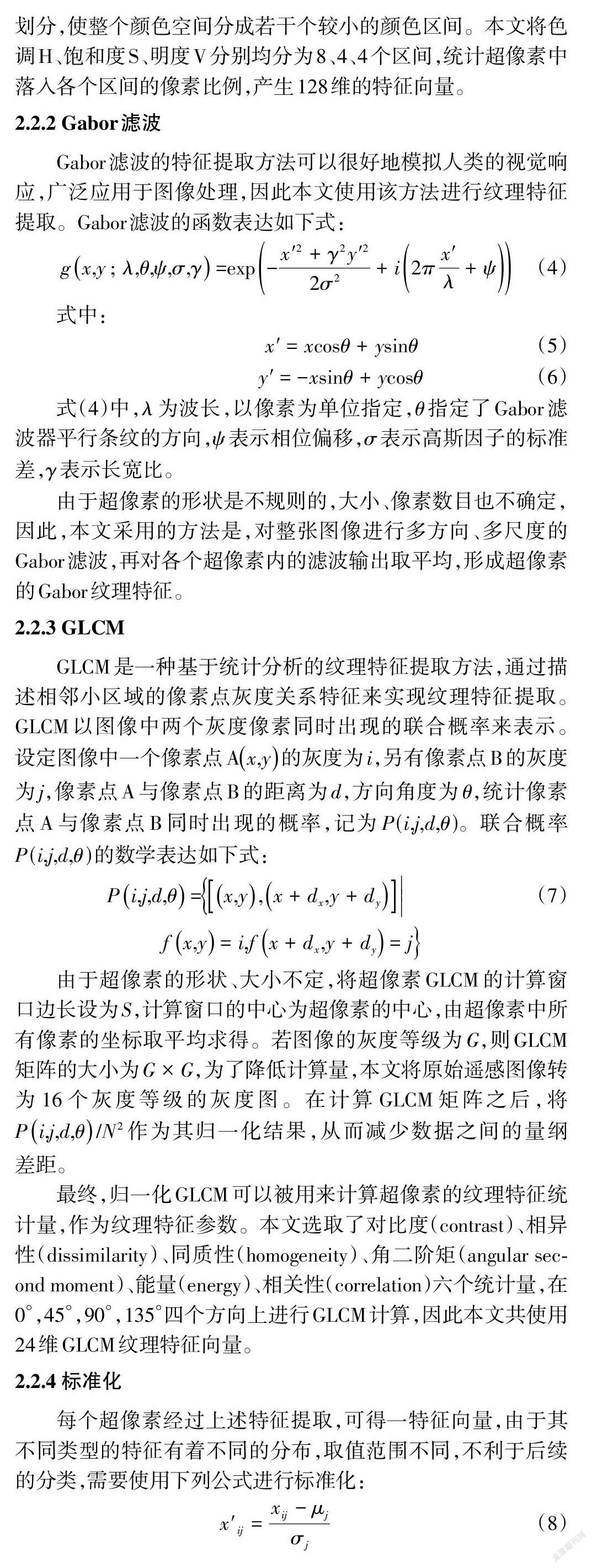

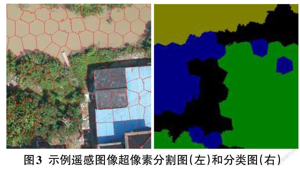
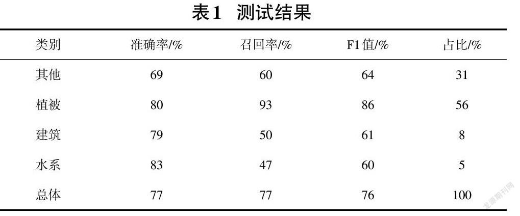
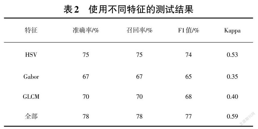
摘要:为了实现输电线路的合理、高效规划,如何准确、快速地进行遥感图像的地表覆盖物分类是值得研究的问题。该文针对高分辨率遥感图像地表覆盖物分类问题,提出了一种基于超像素的方法,其相对于基于像元的方法,减少了椒盐噪声,效率更高,有利于后续的GIS应用。该方法分为图像分割、特征提取、图像分类三个步骤。首先,通过SLIC算法将遥感图像划分为若干个大致均匀的超像素;接着,对超像素的颜色特征、纹理特征进行特征提取;最后,将提取出的超像素特征作为随机森林算法的输入,对超像素进行分类。该文使用提出的方法在泰日线遥感图像上进行测试,取得了有效的结果。
关键词:遥感影像;图像分类;超像素;图像特征;图像分割
中图分类号:TP751 文献标识码:A
文章编号:1009-3044(2021)36-0010-04
开放科学(资源服务)标识码(OSID):
Superpixel-based Classification Algorithm for High-resolution Remote Sensing Images
GONG Bo-tao1, ZHU Qi-feng1, JI Tong-tian1, WANG Hui2
(1. Engineering Construction & Consulting Branch,State Grid Shanghai Municipal Electric Power Company, Shanghai 200120, China; 2. College of Electronic and Information Engineering, Tongji University, Shanghai 201800, China)
Abstract:In order to realize the reasonable and efficient planning of transmission lines, how to accurately and quickly classify the ground cover of remote sensing images is a problem worthy of study. This paper proposes a superpixel-based method for the classification of land cover in high-resolution remote sensing images. Compared with pixel-based methods, this method reduces salt and pepper noise and has higher efficiency, which is beneficial to subsequent GIS applications. The method is divided into three steps: image segmentation, feature extraction, and image classification. First, the remote sensing image is segmented into a number of roughly uniform superpixels using the SLIC algorithm; then, the color features and texture features of the superpixels are extracted; finally, the extracted superpixel features are used as the input of the random forest algorithm to perform classification for superpixels. This paper uses the proposed method to test on the remote sensing image of the Tairi line and obtains effective results.
Key words: remote sensing image; image classification; superpixel; image feature; image segmentation
1 引言
电网前期建设的过程中,由于卫片的清晰度不足,且无法保证时效性,所以需要进行高清航摄来获取建设区域的最新数据。对大量航拍结果进行传统的人工标注费时费力,因此需要一种自动化方法进行标注。当前,遥感影像地表覆盖物分类主要有两种做法:
(1)基于像元的方法
此类方法的分类对象是像元,对于高分辨率遥感图像,由于纹理信息丰富,传统的基于光谱特征和纹理特征的方法难以捕捉到高层语义信息,表现不佳。随着深度学习的兴起,深度学习模型常常被用于基于像元的分类。文献[1-3]使用自动编码器(Auto Encoder,AE)对遥感影像进行分类,但泛化能力较差。……
