基于直升机巡检系统数据的处理的研究与应用
2020-11-13姜诚张建刚李庭坚张福高丰
姜诚 张建刚 李庭坚 张福 高丰
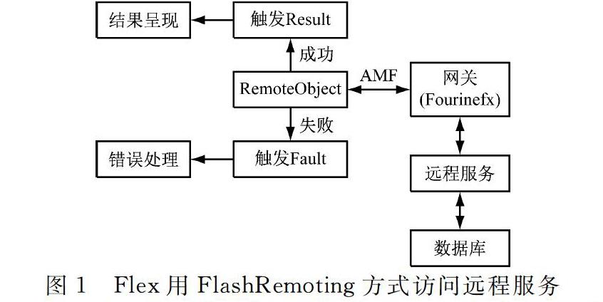
摘要:为提升复杂背景下直升机巡检系统巡检质量,和研究直升机巡检系统的数据处理。通过FlashRemoting应用网关获取数据请求指令完成数据的采集,通过AMF协议实现数据远程传输,通过ArcGISAPIforFlex、Flexframework设计表现层。依照组别功能要求将表现层做分工处理,建立框架模型。服务层由GIS服务器和Web服务器构成,ArcGISServer用于定位系统可为用户提供路线定位服务。通过httpservice类或webservice调用客户端发布的服务,通过API访问ArcGISServer服务端的各类数据,将地图切片技术与GIS服务器动态地图渲染技术进行结合,发布地图服务。采用ModifiedHT算法进行直线提取,调用RemoteDataConnect设置参数查询作业方案获取巡航图,完成巡检系统数据的处理。经实验验证,该算法对复杂背景下航空图像的电力线完整提取是十分有效的,可在直升机巡线系统中得到成功应用,满足巡检质量要求。
关键词:线路巡检;动态数据;视频选帧;地理信息;智慧交通;统计分析
中图分类号:TM726
文献标志码:A
ResearchandApplicationofDataProcessingBasedonHelicopterPatrolInspectionSystem
JIANGCheng1,ZHANGJiangang2,LITingjian3,ZHANGFu4,GAOFeng5
(1.MaintenanceandTestCenter,EHVPowerTransmissionCompany,ChinaSouthernPowerGrid,
Guangzhou510663,China;2.BeijingYupontElectricPowerTechnologyCo.Ltd.,Beijing100029,China)
Abstract:Inordertoimprovetheinspectionqualityofhelicopterpatrolsystemundercomplexbackground,theresearchofdataprocessingbasedonhelicopterpatrolsystemisproposed.DatarequestinstructionisacquiredthroughFlashRemotingapplicationgatewaytocompletedataacquisition,dataremotetransmissionisrealizedthroughAMFprotocol,andthepresentationlayerisdesignedbyArcGISAPIforFlexandFlexframework.Accordingtothefunctionalrequirementsofthegroup,theperformancelayerisdividedintodifferentpartsandaframeworkmodelisestablished.TheservicelayeriscomposedofaGISserverandaWebserver.ArcGISServerisusedforlocationsystemtoprovideroutelocationserviceforusers.Theservicepublishedbyclientisinvokedbyhttpserviceclassorwebservice.ThedataofArcGISServerisaccessedbyAPI.ThemapslicingtechnologyiscombinedwithdynamicmaprenderingtechnologyofGISservertopublishmapservice.ModifiedHTalgorithmisusedtoextractstraightlines,andremotedataconnectisusedtosetparameterstoquerytheoperationplantoobtainthecruisemapandcompletethedataprocessingofthecruiseinspectionsystem.Theexperimentalresultsshowthatthealgorithmisveryeffectiveforthecompleteextractionofpowerlinesfromaerialimagesincomplexbackground,andcanbesuccessfullyappliedinhelicopterpatrolsystemtomeetthequalityrequirementsofpatrolinspection.
Keywords:lineinspection;dynamicdata;videoframeselection;geographicinformation;intelligenttransportation;statisticalanalysis
0引言
直升機巡检作业是我国电网公司推行线路的重要巡检业务模式,综合红外、紫外等先进、高效的手段和应用模式,具有故障及时发现、工作效率高、人工无法替代等优点。可以减轻线路运检班组的工作量,提高巡视的质量,降低线路运检成本、作业风险和劳动强度,不断提升线路运检管理水平[1]。伴随长距离输电线路、大功率、特高压的出现并投入使用,输电线路变得越来越复杂,且资源越来越紧张。在城市发展需求下,输电线路不允许在城市上空交错纷乱排布,所以输电线离城市主要交通要道愈加愈远,一定程度上,对其日常的维护和维修也带来一定的困难。……