钻孔轨迹与样品位置的数字化制图方法研究
2020-08-06颜伟裕,吴承东,李慧,刘浩,杨磊,徐英明
颜伟裕,吴承东,李慧,刘浩,杨磊,徐英明


文章编号:1672-5603(2020)02-80-6
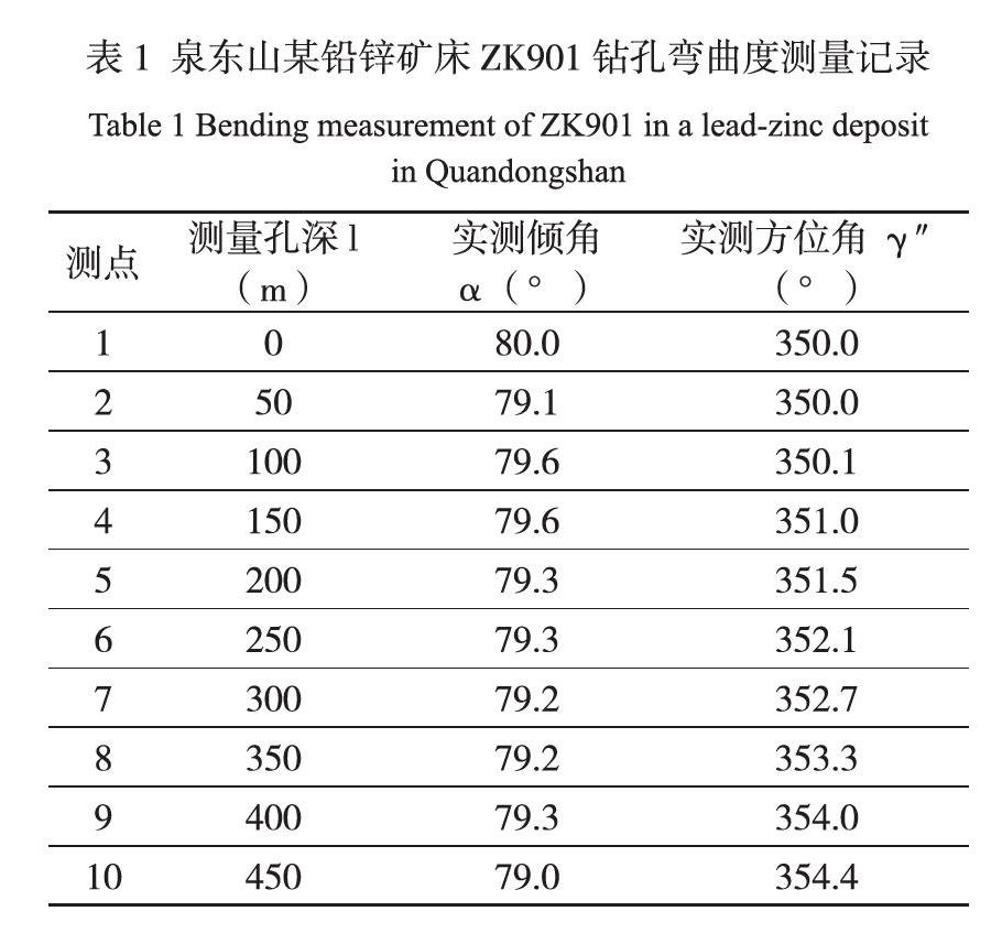
摘 要 为了提高勘查线剖面图样品位置投影的准确度和改变样品须单项独立投影的情况,笔者对钻孔轨迹投影理论、方法和技术进行分析研究,得出了样段控制长度的计算原理方法,实现了由数据直接进机处理数字化生成勘查线剖面图,特别是所有样品可一次性投影成图。本文以哈密地区泉东山某铅锌矿床钻孔ZK901举例,通过数据收集、分析、预处理求得各控制点的投影位置,之后利用Section软件“表格数据投影”功能投影空间坐标,实现了钻孔轨迹、样品位置直接自动投影成图的数字化制图方法。
关键词 数字化; 钻孔轨迹; 投影;样品位置
中图分类号:TP302.4 文献识别码:A
Research on Digital Mapping Method of Drilling Holes
and Sample Position
Yan Weiyu1, Wu Chengdong1, Li Hui1, Liu Hao1, Yang Lei1, Xu Yingming2
(1. Team 304, Hunan Provincial Nuclear Industry Geological Bureau, Changsha Hunan 410000; 2. Hunan Yimidi Planning Consulting Co., Ltd., Changsha Hunan 410000)
Abstract: In order to improve the accuracy of the sample position projection of the survey line profile and to change the situation where the sample must be projected independently, the author analyzes and studies the theory, method and technology of the borehole trajectory projection, and obtains the calculation principle method of the control length of the sample segment to achieve In addition, the data is directly processed into the machine to digitally generate the survey line profile, especially all samples can be projected into a map at one time. In this paper, the ZK901 borehole of a lead-zinc deposit in Quandongshan, Hami area is taken as an example. The projection position of each control point is obtained through data collection, analysis, and preprocessing. Then, the spatial coordinates are projected using the "table data projection" function of Section software to complete the drilling trajectory , The sample position is directly projected into a map automatically to realize digital mapping. The mapping accuracy is high, the data can be shared, and the mapping quality can be checked by the source data.
Keywords: digitization; drilling trajectory; projection; sample location
0 引言
鉆机在施工过程中会产生一定的偏差,因此在后期制作勘查线剖面图中、矿体圈连及储量计算中必须进行钻孔弯曲度校正[1]。以往一般通过对钻孔测斜数据进行计算解析,然后采用手工作图的方法投影到剖面图和平面图上,最后对纸介质底图进行二次描绘后完成计算机制图[2],这占用了地质找矿大量的日常整理工作时间,且成图精度低。随着GIS技术的发展,通过构建投影模型,初步实现了钻孔轨迹自动成图。如何在以往科研的基础上寻求更加简便、更加科学的钻孔轨迹成图方法,以及存在空白区的样品位置一次性自动投影成图的数字化制图技术该如何填补,这是需要探讨的重要问题。下面我们通过对原始数据(测斜和采样井深)的收集、数据预处理,建立投影目标数据,分析探讨钻孔轨迹和样品位置投影过程原理来构建其计算机算法,进而达到自动成图的目的,实现数字化制图。……