森林健康评价的遥感技术研究
2019-06-07马有国杜学惠
马有国 杜学惠
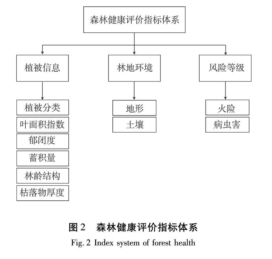
摘要:遥感技术的研究已基本成熟,但将其应用于森林健康评价的研究还相对较少。通过分析遥感技术评价森林健康的可行性和必要性,分析国内外森林健康研究情况及评价指标体系,在综合考虑自然资源、土壤因素、地形因素、火灾和病虫害干扰等方面的基础上,从植被信息、林地环境和森林风险3个方面选取10个能体现森林健康的指标。分析表明:遥感技术评价森林健康是可行的,但也有一定的局限性。多元数据融合不仅可以更全面的提取指标信息,更能提高指标提取精度。发展新型遥感技术、探寻更智能更精确的解译算法,逐渐克服遥感技术在表示植被多样性方面的劣势。
关键词:遥感;森林健康;植被信息;林地环境;森林风险
中图分类号:S771.8文献标识码:A文章编号:1006-8023(2019)02-0037-08
Research on Remote Sensing Technology of Forest Health Assessment
MA Youguo 1,DU Xuehui 2
(1. Ledu District Forestry Bureau, Haidong City, Ledu 810700;
2.College of Technology and Engineering, Northeast Forestry University, Harbin 150040)
Abstract:Researches on remote sensing technology are basically mature, but there are relatively few studies on its application to forest health assessment. By analyzing the feasibility and necessity of evaluating forest health by remote sensing technology, reviewing the progress of forest health research and evaluation index system at home and abroad, based on comprehensive consideration of natural resources, soil factors, topographical factors, fire, pest and disease interference, etc. 10 indicators that reflect forest health are selected in three aspects: information, forest environment and forest risk. The analysis shows that remote sensing technology is feasible to evaluate forest health, but it also has certain limitations. Multivariate data fusion can not only extract indicator information more comprehensively, but also improve the accuracy of index extraction. Develop new remote sensing technologies, explore smarter and more accurate interpretation algorithms, and gradually overcome the disadvantages of remote sensing technology in expressing vegetation diversity.
Keywords:Remote sensing; forest health; vegetation information; woodland environment; forest risk
0引言
森林是地球上最重要的生態系统之一,健康的森林生态系统不仅能为人类提供大量的木材,也能为人类提供经济、生态和社会等诸多效益。森林在调节全球气候变化、保护生态环境和维持生物多样性等多方面起着非常重要的作用,但是这些因素反过来也影响着森林的健康,此外还有如生物入侵、病虫害、火灾、空气污染以及人为砍伐等都威胁着森林的健康发展。
森林健康的概念于20世纪70年代由德国首次提出 [1],随着人们对森林认识的深入,森林健康也引起了越来越多的关注与研究。传统的实地调查数据局限于样本点或样本区域,不能体现大片森林状况,若要对大片区域森林进行研究,势必要花费大量的人力物力和时间,且容易存在数据滞后、难以应对突发状况等弊端,利用遥感技术可以弥补这一不足。……