基于遥感图像的水文特征分析系统设计
2018-04-13巴达日夫
巴达日夫
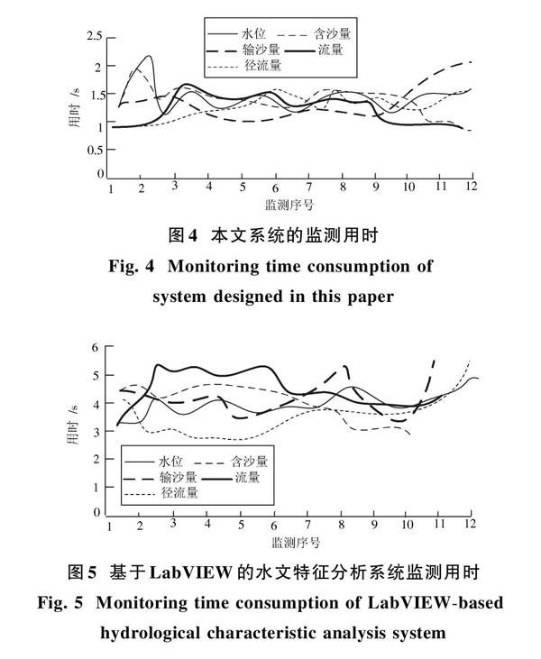
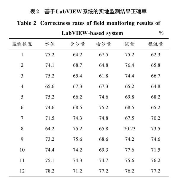
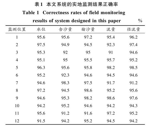
摘 要: 传统基于LabVIEW的水文特征分析系统存在对水文特征监测结果准确率低,监测用时长的问题。因此设计基于遥感图像的水文特征分析系统,采用B/S模式设计系统总体架构,确保用户在搜索需要资料的同时提高系统整体的运行效率。设计的系统显示界面可实现站点查询、水文特征、水文形态、水质监测和底图切换的功能,系统采用的SQL Server数据库包括遥感影像数据库、水文特征信息数据库和资料管理维护数据库,完成水文特征数据的全面存储。水文特征分析模块采取数据预处理、水流的流向分析、汇流累积量计算以及河网生成等操作,对水文特征进行全面、准确分析,系统中的水位预警分析模块通过对水域水位进行监测,依照不同安全级别将水位监测结果进行划分,实现对危险水位的准确预警。实验结果表明,所设计系统能对水文特征进行准确分析,具有较高的监测效率。
关键词: 水文特征分析; 水资源评价; 地下水; GIS; 水文地质结构; 遥感图像
中图分类号: TN911.73?34; TU991 文献标识码: A 文章编号: 1004?373X(2018)08?0068?04
Abstract: The traditional hydrological characteristic analysis system based on LabVIEW has problems of low accurate hydrological characteristic monitoring results and long monitoring time. Therefore, a hydrological characteristic analysis system based on remote sensing images is designed. The B/S mode is adopted to design the overall architecture of the system to ensure that the overall operation efficiency of the system can be improved while users are searching the materials they need. Functions of site query, hydrological characteristic monitoring, hydrological pattern monitoring, water quality monitoring and base map switching are realized on the designed display interface of the system. The SQL Server database which includes remote sensing image database, hydrological characteristic information database and material management and maintenance database is adopted in the system to achieve overall storage of hydrological characteristic data. In the hydrological characteristic analysis module, operations such as data preprocessing, water flow direction analysis, river flow accumulation calculation, and river network generation are conducted for comprehensive and accurate analysis of hydrological characteristics. The water level warning analysis module is adopted in the system to execute monitoring according to the water level of water area and divide the security levels of water level monitoring results to achieve accurate warning of danger water levels. The experimental results show that the designed system can accurately analyze hydrological characteristics and has high monitoring efficiency.
Keywords: hydrological characteristic analysis; water resource assessment; underground water; GIS; hydrogeological structure; remote sensing image
0 引 言
近年來,随着经济的发展、人口数量的增长以及大量的能源消耗,导致洪灾旱灾的发生日益频繁,使水域附近的生态环境承受巨大压力。为降低水域周边环境的恶化速度,以及加强政府部门对水域的动态掌握,有必要建立水文特征分析系统。遥感技术以其监测范围广[1],获取有效信息的用时短以及不受地理条件约束等特点,被广泛地应用在水文特征分析中。……