粮豆轮作遥感监测对卫星时空及谱段指标的需求分析
2018-04-11王利民杨福刚杨玲波季富华
刘 佳,王利民,杨福刚,杨玲波,季富华
粮豆轮作遥感监测对卫星时空及谱段指标的需求分析
刘 佳,王利民※,杨福刚,杨玲波,季富华
(中国农业科学院农业资源与农业区划研究所,北京 100081)
该文面向粮豆轮作遥感监测卫星数据需求,针对最小监测地块、作物类型、时效性的要求,分别对不同空间分辨率影像识别能力、不同波段组合识别能力、最高云覆盖区域晴空获取能力3个方面进行分析,提出了光学遥感卫星理想的空间分辨率要优于0.3 m,光谱设置可以采取基本波段(蓝、绿、红、近红)+红边或者基本波段(蓝、绿、红、近红)+短波谱段2种方式,重访周期要达到3 d以内。在上述指标满足条件下,能够对中国普遍存在的0.3 m宽度田埂进行有效识别,从而达到地块识别的目标;能够利用作物红边、短波谱段特征的差异,对生长中期玉米、大豆进行有效识别,达到粮豆轮作主要作物类型识别的目的;以3 d的重访周期,可以最大限度获取覆盖中国全国区域的晴空有效影像,在数据源获取上保证粮豆轮作业务化作业能力。该研究可为满足中国粮豆轮作等农情遥感监测需求的农业监测卫星研制及相应指标规定提供参考。
农作物;遥感;轮作;核查;中国;高分辨率;卫星数据
0 引 言
遥感技术具有效率高、成本低等优势,近20 a来遥感技术快速发展,以农业生产监测应用为主要目标的农业卫星研制的条件已经成熟。农作物种植结构调整是保证中国农业绿色可持续发展的基本国策,在中国的“镰刀弯”地区,即东北冷凉区、北方农牧交错区、西北风沙干旱区、太行山沿线区及西南石漠化区,通过减少籽粒玉米种植面积,重点发展青贮玉米、大豆、杂粮杂豆、春小麦、经济林果和生态功能型植物等,实现稳粮增收、提质增效和可持续发展,玉米-大豆轮作的方式是其中重要的调整方式之一。相比于已经在轮作休耕上取得较好成果的国家,中国还处于初级探索阶段[1-2],目前主要多从不同轮作复种模式比较[3-6]、轮作对土壤环境的影响[7-11]等方面进行研究,对于轮作的遥感核查方面报道较少,针对这一需求为依托的卫星能力建设研究也较少。
基于遥感技术开展耕地轮作监测研究,从研究内容上看可以包括耕地轮作和农作物类型识别遥感监测研究两个方面。直接以耕地轮作作为研究对象进行的遥感监测方法研究,一般以中低空间分辨率遥感数据源为主[12-16],主要注重于区域尺度上农业生态规律分析[17-21],如Lunetta等[22]采用MODIS数据对劳伦森大湖流域的2005‒2007年玉米、大豆与小麦轮作进行分析,结果2005‒2006年的玉米、大豆面积相对平衡,2006‒2007年玉米面积增长21%,大豆、小麦面积分别下降9%和21%。而在农作物类型遥感识别研究方面,与耕地轮作遥感监测研究紧密相关的是变化检测方法及相关的分类技术研究[23-33]。如Sun等[34]、Li等[35]、Shapla等[36]使用Landsat或MODIS卫星数据,对不同区域水稻种植面积的变化情况进行监测,分别取得了86.91%(Sun等)、95%(Li等)的总体精度和0.82(Shapla等)的Kappa系数;王学等[37]使用2001‒2011年MODIS时序数据,发现华北平原2001‒2011年间冬小麦种植面积持续扩大,且呈现南增北减格局,为华北平原调整农业种植结构提供了借鉴。
上述研究主要依托于已有的卫星影像展开的,或在卫星发射之后对卫星的应用性能进行评估[38-39],而针对当前具体业务需求及今后发展方向,有针对性提出行业卫星主要应用指标的研究还很少,且主要集中在气象、测绘等卫星应用领域[40],如黄富祥等[41]则针对现有气象卫星应用需求分析的不足,以定量指标的形式,设计并进行了中国气象卫星的应用需求调查;唐新明等[42]介绍和总结国际和国内测绘卫星现状的基础上,根据中国的发展需求提出了中国未来测绘卫星及技术的发展方向,提出了提高分辨率、加强测绘卫星应用研究、鼓励市场化等建议。
农业种植结构调整是推进农业供给侧结构性改革的重要内容之一,尤其是“粮豆轮作”工作遥感监测工程,为农业政策制定、补贴发放、效果评估提供精确参考,已经成为中国当前农业遥感的重要应用方向[43]。由于“粮豆轮作”监测结果直接关系到农民的切身利益以及国家惠农补贴的精准发放,已经超越传统农业遥感监测对于遥感数据源分辨率、精度等指标要求较低的现状(如应用较多的MODIS 250 m、Landsat 30 m、GF-1 16 m分辨率),应用亚米级遥感卫星进行农业监测已成为农业应用领域迫切需求[22]。该文在中国“镰刀弯”地区内,以玉米-大豆轮作这一比较广泛的农作物轮作方式为研究对象,从遥感数据空间、时间分辨率、光谱3个方面入手,具体分析了玉米-大豆轮作遥感监测数据指标需求,并为今后中国农业行业卫星的需求调研提供参考。
1 农作物轮作遥感核查的技术流程
“镰刀弯”地区具体包括河北、山西、内蒙古、辽宁、吉林、黑龙江、广西、贵州、云南、陕西、甘肃、宁夏、新疆这13个省区[44],该地区位于生态薄弱区,主要以种植玉米为主,但因其不处于玉米种植优势区,产量较低,因此将这一区域划为调整玉米结构的重点地区,以其他优势作物如大豆等进行替代性种植,并利用遥感技术对轮作面积进行精确核查。
当前粮豆轮作遥感核查业务由4个步骤组成,即作物地块边界获取、作物类型识别、精度验证、汇总统计,图1给出了玉米-大豆轮作遥感监测的具体流程。以下对粮豆轮作遥感监测主要技术流程作细致分析,并在此基础上分析轮作遥感核查业务对卫星影像指标的需求情况。
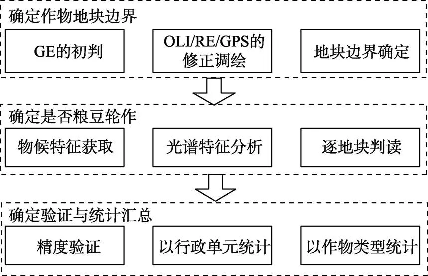
图1 农作物轮作遥感核查技术流程
1.1 作物地块种植边界的获取
利用高分辨率遥感影像确定地块边界,为轮作核查提供准确地块矢量。在实际工作中,都是以田埂作为地块识别边界,采用目视修正方法进行识别。具体的技术流程包括资料准备、遥感影像初判、实地核查3个步骤。
资料准备的主要内容是收集监测区域农户地块的具体产权信息以及地块的粗略位置、大小等。遥感影像初判指的是基于高分辨率影像,目视判读绘制地块范围。由于卫星影像难以精确识别细小田埂,因此主要使用无人机航拍等方式获取精确的地块边界[45],其空间分辨率通常在0.1 m以上。实地核查则使用RTK(real-time kinematic,实时动态)载波相位差分技术对地块的边界进行准确测量并对遥感提取结果进行精度验证[45]。
地块边界获取是作物轮作监测的基础,必须有高分辨率、高定位精度的遥感影像作为基础,由于航拍方式覆盖范围小、成本高、耗时长,使用高分辨率卫星影像作为替代已成为“粮豆轮作”工程遥感监测的迫切需求。
1.2 地块上作物类型的识别
在获取精确的作物种植地块数据的基础上,使用多源多时相卫星影像数据结合地面实地勘察的方式确定地块内作物类别。主要的技术流程包括遥感影像数据筛选及处理、时序遥感影像作物识别、识别结果与作物地块套合、地面补充调查及验证等内容。
作物识别的常用数据源以中高分辨率的卫星影像为主,包括GF、Rapideye、Landsat、 Sentinel等数据,一般需获取包括作物生长的早期、中期和晚期3个时期的多时相遥感数据。识别的常用方法是根据作物物候特征,判断不同作物在遥感影像上的时序光谱特征,选取典型地类样本,并使用监督、非监督等方法进行分类。
在此基础上,套合精确的地块矢量,确定地块作物类型,并逐地块进行验证和修改,并对无法识别地块进行实地调查。最后,依据相邻年份作物精确的识别结果,确定粮豆轮作的具体范围、面积以及地块权属,从而为补贴发放提供依据。
当前,作物类型遥感识别的主要问题在于数据源的缺乏:一方面高分辨率卫星数据的时效性难以保障,重访周期过长,覆盖范围较小,无法获取充足晴空数据,如GF-2的最高分辨率达到0.8 m,但回归周期却长达69 d;另一方面,中分辨率如GF-1/WFV虽然具有较高的重访周期(标称4 d),但其较低的分辨率、较少的波段设置(仅有可见光和近红外4个波段)使其难以有效识别破碎地块作物类型。获取具有高重访周期、多波段设置、高空间分辨率的卫星影像,对于农作物轮作遥感核查工作至关重要,而高空间分辨率与高重访周期的矛盾,可通过建立多卫星星座的方式进行部分解决。
1.3 轮作遥感监测结果的精度验证
农作物轮作遥感监测精度验证包括地块面积量算精度和地块作物类型识别精度,使用地面调查方式逐地块展开,原则要求精度是100%;此外,若监测结果显示轮作任务未达预定要求,则需要进行二次调查核实。在轮作遥感监测工作全面展开后,使用抽样调查取代全覆盖调查,并使用无人机调查的方式对地面调查方法进行补充,提高效率。
在实际工作中,根据中国《数字航空摄影测量空中三角测量规范》(GBT 23236—2009),只要遥感数据分辨率大于0.3 m,平面位置中误差不大于3.5 m,面积监测的实际精度能达到99.5%以上,比农户传统的估算更为准确,也能够为农户所认可[46]。
2 农作物轮作核查遥感监测的卫星数据需求
根据农作物轮作遥感核查技术的实际需求,对卫星载荷指标按照空间分辨率、光谱分辨率、时间分辨率等3个方面进行探讨。空间分辨率与地块面积量算精度、最小地块识别尺度紧密相关,光谱分辨率与不同作物识别能力紧密相关,时间分辨率与影像周期性获取能力密切相关。玉米-大豆轮作是粮豆轮作的主要方式,“镰刀弯”地区是粮豆轮作的重点区域,且基本从西到东,从北到南横跨中国大部分区域,因此,该文就中国陆地范围内玉米-大豆轮作方式开展监测,对遥感卫星数据的需求作简要论述。
2.1 对遥感数据空间分辨率的需求
空间分辨率关系到量算精度和最小地块识别2个方面。前面已经提到,量算精度要求的是0.3 m空间分辨率,这里分析一下最小识别地块的要求。中国农作物地块破碎度程度较大,并且在东北、华北、西北、华东、华中、华南以及西南等地区破碎度程度也不尽一致,但如果以最小地块衡量则能简化这一问题。在中国,田埂宽度一般为0.3 m左右[47-48],也是轮作监测中需要识别的最小宽度,此外中国东北地区有部分农户习惯于单垄条播[49],其最小宽度也在0.3 m左右,这就对粮豆轮作卫星遥感数据源的分辨率指标进行了限制。图2给出了无人机影像对0.3 m宽田埂识别效果,可以看出,在0.1 m分辨率下,地面实际宽度0.3 m的线状田埂能够清晰识别;0.2 m空间分辨率下,结合地面调查 经验,也可以定性为田埂;在0.3 m分辨率下,从影像上已较难区分出田埂,仅能对田埂两侧的作物进行划分。

图2 不同空间分辨率无人机影像对0.3 m宽度田埂识别能力的比较
而根据王利民等[50]研究,当影像分辨率由2 m变为250 m时,作物面积识别的总体精度逐步由98.6%降低到70.1%,面积误差绝对值比例由5.5%扩大到110.6%;破碎度越高的地区,分辨率提高对于作物面积提取精度的提升作用越明显;同等分辨率下,破碎度越高的地区面积识别精度越低。可见,提高影像分辨率对于提高作物识别的精度具有重要的作用,尤其在地类破碎区域。
就卫星研制能力角度来看,优于0.3 m空间分辨率民用遥感影像目前还不多见。暂时不考虑传感器材料与技术限制因素,仅以以往不同空间分辨率卫星出现的时间周期,估计优于0.3 m空间分辨率数据未来能够普遍获取的时间。30、15 m空间分辨率的Landsat-TM数据分别出现在1982年、1999年;20、10、2.5、1.5 m空间分辨率的SPOT数据分别出现在1986年、1986年、2002年、2012年;5 m空间分辨率的Rapideye数据出现在2008年;0.5、0.3 m空间分辨率的Worldview数据出现在2007年、2014年,也是当前分辨率最高的商业卫星;另据报道,美国KH-12卫星的分辨率已达0.1 m[51]。而在国内卫星中,资源一号卫星分辨率20 m,发射于1999年,比SPOT同分辨率卫星晚13 a;资源三号卫星分辨率2.1 m,发射于2012年,比同分辨率的SPOT卫星晚10 a;而随着2018年1月9日高景一号03/04星发射升空,形成最高分辨率0.5 m的卫星星座,相比Worldview同分辨率卫星晚9 a。可以看出,国内卫星与国际卫星最高分辨率的差距不断缩小,若按9 a一个台阶推测,则估计2023年左右能达到2014年发射的Worldview3卫星0.3 m分辨率水平,并在2032年左右达到0.1 m分辨率。
通过上述分析,可以认为0.3 m空间分辨率的遥感影像能够满足农作物轮作遥感监测中以窄小田埂分界的地块的识别,但是难以满足条播地块识别的需要;而0.1 m空间分辨率卫星遥感影像能够完全满足农作物轮作遥感监测的影像分辨率需求;同时预计在2023年、2032年左右能够获取0.3 m和0.1 m空间分辨率的数据。
2.2 对遥感数据光谱谱段设置的需求
虽然高光谱数据包含更丰富的波谱信息,但是由于传感器制作技术、获取能力和成本、处理技术等的限制,可以预见多光谱数据仍然是农作物轮作识别唯一的选择。用于农作物遥感识别多光谱波段范围除可见光-近红外(0.450 ~0.890m)、短波红外(1.560 ~2.300m)两大类外,海岸蓝(0.433 ~0.453m)、黄边(0.585~0.625m)、红边(0.690 ~0.730m)等范围谱段在一些传感器中也开始出现[52],应用较为成熟的主要是红边谱段[53-54]。下文分别选取覆盖黑龙江省北安市东胜乡的2014年7月27日Rapideye和2014年8月7日Landsat-8 OLI卫星影像,从可见光-近红外、红边、短波红外3个谱段出发,讨论农作物轮作监测对遥感数据光谱谱段设置需求。在这一时间段内,玉米处于抽雄-乳熟期,大豆处于结痂期,作物生长旺盛,有利于遥感识别。识别方法使用最大似然分类算法,精度验证数据则使用Rapideye影像目视解译结合地面调查精修正成果。
图3a、3b、3c分别是Rapideye影像5(近红)-4(红边)-3(红)波段、OLI影像5(近红)-4(红)-3(绿)波段、OLI影像6(短波)-5(近红)-4(红)波段的RGB假彩色合成效果。表1则给出了可见光-近红、可见光-近红-红边、可见光-近红-短波谱段玉米、大豆分类的精度。除玉米、大豆外,研究区其他地类主要包括城镇、水体及林地、河滩草地,其中林地NDVI值均较其他地类高,而河滩草地NDVI则较低,均易与玉米和大豆进行区分。

表1 红边及短波红外波段对玉米和大豆分类精度的影响
由图3可见,仅有可见光-近红外波段的影像,玉米、大豆都呈红色基调,只是玉米暗红色,大豆亮红色。有红边的影像,玉米、大豆呈现不同的色调,玉米呈红色、大豆呈黄色。有短波红外的影像,玉米、大豆呈现黄色调,玉米呈棕红色,大豆呈杏黄色,较仅有可见光-近红外波段的红色调影像更容易区分,效果与红边类似。由表1可见,就红边波段而言,无红边和有红边2种情况下,总体精度分别为73.1%和80.5%,提高了7.4个百分点,玉米和大豆的用户精度分别提高了16.6和3.7个百分点,制图精度分别提高了11.0和11.6个百分点;就短波波段而言,无短波和有短波2种情况下,总体精度分别为65.7%和74.7%,提高了9.0个百分点,玉米和大豆的用户精度分别提高了2.8和17.4个百分点,制图精度分别提高了10.3和6.4个百分点。
综上分析可以明确,以蓝、绿、红、近红波段为基础,增加红边、短波红外谱段,形成包括蓝、绿、红、红边、近红、短波红外谱段的多光谱谱段,将能够有效提高玉米、大豆的识别能力,也就提高了农作物轮作遥感监测能力。其中,具体谱段设置可以参考现有GF、Rapideye及OLI传感器的设置,蓝、绿、红、近红波段为0.45~0.52m、0.52~0.59m、0.63~0.69m和0.77~ 0.89m,红边谱段为0.690~0.730m,短波谱段为1.560~ 1.660m和2.100~2.300m。

图3 北安Rapideye和OLI数据不同波段假彩色合成效果比较
2.3 对遥感数据观测频率设置的需求


从图4可见,晴空概率最低的地区为四川和贵州地区,约为30%,其中贵州地区属于“镰刀弯”地区中的西南石漠化区,假设以此区域作为监测区域,以生育期较短的大豆作为监测作物,以此计算符合农作物轮作监测需求的卫星重访周期。大豆的生育期一般在90~110 d左右,其种植后第一个月为生长早期,第二个月为生长中期,第三个月为生长晚期。根据式(2)可以计算出,若需要保证每个生育期均有85%的概率至少有一景晴空影像,则卫星的重访周期应在6 d以内;而若能达到3 d的重访周期,则能保证90%以上的概率获取3个生育期连续的时间序列光谱曲线。

图4 中国区域平均晴空分布概率
3 讨 论
耕地轮作是用地养地相结合的一种生物学措施,合理的轮作休耕有助于抑制杂草及病虫害,改善植物养分的供给,防止土壤流失,降低水资源的污染,农作物轮作休耕制度已经成为中国农业可持续发展的国策。利用高空间分辨率卫星影像,实现对轮作休耕地块空间位置、面积准确监测,避免传统统计上报中人为因素的干扰,为农户补贴精准发放提供科学客观的依据。该文从分辨率、重访周期、光谱谱段3方面出发,为满足粮豆轮作监测需求的卫星载荷设计提供具体依据,以指导未来农业卫星的设计与规划。
根据需求分析结果,该文提出高、中、低3种农业卫星指标需求模式。第一种是高指标模式,即0.1 m空间分辨率,蓝、绿、红、红边、近红和短波谱段设置,重访周期3 d。该模式可在不使用其他遥感数据源辅助下,满足全国极端多云多雨区玉米-大豆轮作的遥感监测需求。第二种是中等指标模式,0.3 m空间分辨率,蓝、绿、红、红边、近红和短波谱段设置,6 d的重访周期。该模式需要在其他0.1 m遥感数据或地面实测数据辅助下获取条播等地块信息,在极端云雨天气下亦有较高的概率获取晴空影像。第三种是低指标模式,0.3 m空间分辨率,基本波段(蓝、绿、红、近红)+红边或者基本波段+短波选择其一的谱段设置方式,6 d重访周期。该模式与中等模式相比,通过降低谱段数量降低卫星研制成本,但由于减少红边或短波波段,可能会造成其他地物与玉米、大豆混淆,影响识别精度。
此外,该文提出的光学卫星指标的需求分析,是仅就粮豆轮作遥感监测需求提出的。在卫星载荷实际设计时,还需要考虑卫星载荷设计制造能力及成本耗费,并兼顾其他农业工程项目的监测需求,提出一个相对通用的卫星设计指标,为农业遥感卫星体系建设奠定基础。
4 结 论
1)为满足农作物轮作遥感核查业务需求,农业遥感卫星的空间分辨率需要达到0.1 m;在当前技术条件无法满足的条件下,空间分辨率可设置为0.3 m,并在地面无人机航拍数据或地面GPS设备辅助采集地块田埂边界或条播作物地块。根据国内外卫星影像分辨率发展特点,粗略估计最晚至2023年可获取0.3 m分辨率国产卫星影像,2032年获取0.1 m分辨率国产卫星影像。
2)为满足农作物轮作遥感核查业务需求,农业遥感卫星的重访周期应能达到3 d左右;由于高时间分辨率与高空间分辨率之间的矛盾,在技术条件不足情况下,可以将重访周期设置为6 d左右,基本可以满足绝大部分农作物轮作遥感核查区域的监测遥感数据需求。此外,可以采用多卫星组网形成卫星星座的方式,进一步提高卫星的重访周期。
3)为满足农作物轮作遥感核查业务需求,农业遥感卫星的谱段在覆盖基本波段(蓝、绿、红、近红,范围0.450~0.890m)外,应当尽量包含红边(0.690~0.730m)及短波红外波段(1.560~1.660m和2.100~2.300m),或至少包含两者之一。
[1] 《土壤观察》编辑部.各国轮作休耕制度有何借鉴[J].国土资源,2017(1):58-59.
[2] 杨庆媛,信桂新,江娟丽,等.欧美及东亚地区耕地轮作休耕制度实践:对比与启示[J].中国土地科学,2017,31(4):71-79. Yang Qingyuan, Xin Guixin, Jiang Juanli, et al. The comparison and implications of crop rotation and fallow in the Western countries and East Asia[J]. China Land Sciences, 2017, 31(4): 71-79. (in Chinese with English abstract)
[3] 丁淘沙.基于遥感技术对河南省永城市农作物三种轮作方式经济适宜性评价研究[J].福建电脑,2017(5):93-94,172.
[4] 李锋瑞,高崇岳.陇东黄土高原若干轮作复种模式的生态效能比较研究[J].草业学报,1994,3(1):48-55. Li Fengrui, Gao Chongyue. A comparison of comprehensive Eco-efficiencies between some rotation and multiple cropping patterns and continuous winter wheat cropping in the loess plateau of Eastern Gansu[J]. Acta Prataculturae Sinica, 1994, 3(1): 48-55. (in Chinese with English abstract)
[5] 胡志桥,田宵鸿,张久东,等.石羊河流域节水高产高效轮作模式研究[J].中国生态农业学报,2011,19(3):561-567. Hu Zhiqiao, Tian Xiaohong, Zhang Jiudong, et al. High efficiency production and water-saving crop rotation systems in Shiyang River Area[J]. Chinese Journal of Eco-Agriculture, May 2011, 19(3): 561−567. (in Chinese with English abstract)
[6] 李明.半干旱地区不同轮作方式的综合评价[D].太谷:山西农业大学,2015. Li Ming. Comprehensive Evaluation of Different Crop Rotation Way in Semi Arid Area[D]. Taigu: Shanxi Agricultural University, 2015. (in Chinese with English abstract)
[7] 李秀娟,赵庚星,李涛,等.山东青州市耕地利用方式对土壤养分状况影响研究[J].地域研究与开发,2005,24(3):107-111. Li Xiujuan, Zhao Gengxing, Li Tao, et al. Effects of different arable land use on soil nutrients in Qingzhou county of Shandong province[J]. Areal Research and Development, 2005, 24(3): 107-111. (in Chinese with English abstract)
[8] 陈先茂,彭春瑞,关贤交,等.红壤旱地不同轮作模式的效益及其对土壤质量的影响[J].江西农业学报,2009,21(6):75-77. Chen Xianmao, Peng Chunrui, Guan Xianjiao, et al. Benefit of different crop rotation modes and their effects on quality of red-yellow dry soil[J]. Acta Agriculture Jiangxi, 2009, 21(6): 75-77. (in Chinese with English abstract)
[9] 宋丽萍,罗珠珠,李玲玲,等.陇中黄土高原半干旱区苜蓿—作物轮作对土壤物理性质的影响[J].草业学报,2015,24(7):12-20. Song Liping, Luo Zhuzhu, Li Lingling, et al. Effect of Lucerne-crop rotations on soil physical properties in the semi-arid loess plateau of central Gansu[J]. Acta PrataculturaeSinica, 2015, 24(7): 12-20. (in Chinese with English abstract)
[10] 陈书涛,黄耀,郑循华,等.轮作制度对农田氧化亚氮排放的影响及驱动因子[J].中国农业科学,2005,38(10):2053-2060. Chen Shutao, Huang Yao, Zheng Xunhua, et al. Nitrous oxide emission from cropland and its driving factors under different crop rotations[J]. Scientia Agricultura Sinica, 2005, 38(10): 2053-2060. (in Chinese with English abstract)
[11] 蔡艳,郝明德.轮作模式与周期对黄土高原旱地小麦产量、养分吸收和土壤肥力的影响[J].植物营养与肥料学报,2015,21(4):864-872. Cai Yan, Hao Mingde. Effects of rotation model and period on wheat yield,nutrient uptake and soil fertility in the Loess Plateau[J]. Journal of Plant Nutrition and Fertilizer, 2015, 21(4): 864-872. (in Chinese with English abstract)
[12] 李正国,杨鹏,周清波,等.基于时序植被指数的华北地区作物物候期/种植制度的时空格局特征[J].生态学报,2009,29(11):6216-6226. Li Zhengguo, Yang Peng, Zhou Qingbo, et al. Research on spatio-temporal pattern of crop phenological characteristics and cropping system in North China based on NDVI time series data[J]. Acta EcologicaSinica, 2009, 29(11): 6216-6226. (in Chinese with English abstract)
[13] 闫慧敏,黄河清,肖向明,等.鄱阳湖农业区多熟种植时空格局特征遥感分析[J].生态学报,2008,28(9):4517-4523. Yan Huimin, Huang Heqing, Xiao Xiangming, et al. Spatio —temporal distribution of multiple cropping systems in the Poyang Lake region[J]. Acta EcologicaSinica, 2008, 28(9): 4517-4523. (in Chinese with English abstract)
[14] 顾晓鹤,潘瑜春,王堃,等.耕地轮作模式遥感监测[J].中国土地科学,2011,25(12):68-74. Gu Xiaohe, Pan Yuchun, Wang Kun, et al. Monitoring the pattern of crop rotation through remote sensing[J]. China Land Science, 2011, 25(12): 68-74. (in Chinese with English abstract)
[15] Wardlow B D, Egbert S L, Kastens J H. Analysis of time-series MODIS 250m vegetation index data for crop classification in the U.S. Central Great Plains[J]. Remote Sensing of Environment, 2007, 108(3): 290-310
[16] Jia Kun, Wu Bingfang, Li Qiangzi. Crop classification using HJ satellite multispectral data in the North China plain[J]. Journal of Applied Remote Sensing, 2013, 7: 1-12.
[17] 吕婷婷,刘闯.中国珠江三角洲与东南亚四大三角洲多熟种植制度的时空格局研究[J].资源科学,2009,31(10):1662-1669. Lv Tingting, Liu Chuang. Spatio-temporal distributions of multiple cropping systems in the Pearl River Delta of China and four deltas in Southeast Asia[J]. Resources Science, 2009, 31(10): 1662-1669. (in Chinese with English abstract)
[18] 彭光雄,胡德勇,陈锋锐,等.基于空间信息的烤烟种植适宜性评价与轮作规划[J].地理研究,2010,29(5):873-882. Peng Guangxiong, Hu Deyong, Chen Fengrui, et al. Evaluation of flue-cured tobacco planting suitability and crop rotation planning based on spatial information[J]. Geographical Research, 2010, 29(5): 873-882. (in Chinese with English abstract)
[19] Stern Alan J, Doraiswamy P C, Hunt E R. Changes of crop rotation in Iowa determined from the United States Department of Agriculture, National Agricultural Statistics Service cropland data layer product[J]. Journal of Applied Remote Sensing, 2012, 6(1): 1-16.
[20] Claire Boryan, Zhengwei Yang, Rick Mueller, et al. Monitoring US agriculture: the US department of agriculture, national agricultural statistics service, cropland data layer program[J]. Geocarto International, 2011, 26(5): 341-358.
[21] 刘佳,王利民,滕飞,等.玉米大豆轮作遥感监测技术研究[J].中国农学通报,2017,33(8):144-153. Liu Jia, Wang Limin, Teng Fei, et al. Corn-soybean crop rotation remote sensing monitoring technologies[J]. Chinese Agricultural Science Bulletin, 2017, 33(8): 144-153. (in Chinese with English abstract)
[22] Lunetta R S, Shao Y, Ediriwickrema J, et al. Monitoring agricultural cropping patterns across the Laurentian Great Lakes Basin using MODIS-NDVI data.[J]. International Journal of Applied Earth Observation & Geoinformation, 2010, 12(2): 81-88.
[23] Celik T, Ma Kaikuang. Unsupervised change detection for satellite images using Dual-Tree complex wavelet transform[J]. IEEE Transactions on Geoscience & Remote Sensing, 2010, 48(3): 1199-1210.
[24] 钟家强.基于多时相遥感图像的变化检测[D].长沙:国防科学技术大学,2005. Zhong Jiaqiang. Change Detection Based on Multitemporal Remote Sensing Image[D]. Changsha: National University of Defense Technology, 2005. (in Chinese with English abstract)
[25] 张振龙,曾志远,李硕,等.遥感变化检测方法研究综述[J].遥感信息,2005(5):64-66,59. Zhang Zhenlong, Zeng Zhiyuan, Li Shuo, et al. A summary of change detection methods of remote sensing image[J]. Remote Sensing Information, 2005(5): 64-66, 59. (in Chinese with English abstract)
[26] 班松涛.县域农作物类型遥感识别与提取—以扶风县为例[D].杨凌:西北农林科技大学,2014. Ban Songtao. Recognition and Extraction of Agricultural Crops on County Scale Using Remote Sensing Technology: A Case Study of Fufeng County[D]. Yangling: Northwest A&F University, 2014.(in Chinese with English abstract)
[27] 陶青山,黄飞,雷帆,等.湖南省中稻种植面积遥感监测方法研究[J].安徽农业科学,2016(4):309-313. Tao Qingshan, Huang Fei, Lei Fan, et al. The Remote-sensing monitoring methods of rice planting area in Hunan province[J]. Journal of Anhui Agri. Sci., 2016,44(4): 309-313. (in Chinese with English abstract)
[28] 黄维,黄进良,王立辉,等.多时相遥感影像检测平乐县晚稻种植面积变化[J].农业工程学报,2014,30(21):174-183. Huang Wei, Huang Jinliang, Wang Lihui, et al. Detection of late rice’s planting area change in Pingle County based on multi-temporal remote sensing images[J]. Transactions of the Chinese Society of Agricultural Engineering (Transactions of the CSAE), 2014, 30(21): 174-183. (in Chinese with English abstract)
[29] 王凯.基于多源卫星遥感的湖化省作物耕作面积提取及其动态监测[D].荆州:长江大学,2013. Wang Kai. Based on Multi-source Satellite Remote Sensing Extraction of Crop Cultivation Area in Hubei Province and Its Dynamic Monitoring[D]. Jingzhou: Yangtze University, 2013. (in Chinese with English abstract)
[30] 王晓昕,范燕敏,武红旗.基于GF-1影像的玉米识别方法研究[J].山东农业科学,2017,49(6):139-142. Wang Xiaoxin, Fan Yanmin, Wu Hongqi. Maize recognition methods based on GF-1 images[J]. Shandong Agricultural Sciences, 2017, 49(6): 139-142. (in Chinese with English abstract)
[31] 胡君德,萨楚拉,谷俊杰,等.基于TM数据的玉米种植面积变化研究——以科尔沁左翼中旗为例[J].阴山学刊,2017,31(2):75-80. Hu Junde, Sa Chula, Gu Junjie, et al. Study on the change of corn acreage based on TM data: Taking Horqin Left Middle Banner as an example[J]. Yinshan Academic Journal, 2017, 31(2): 75-80. (in Chinese with English abstract)
[32] 黄健熙,侯矞焯,苏伟,等.基于GF-1 WFV数据的玉米与大豆种植面积提取方法[J].农业工程学报,2017,33(7):164-170. Huang Jianxi, Hou Yuzhuo, Su Wei, et al. Mapping corn and soybean cropped area with GF-1 WFV data[J]. Transactions of the Chinese Society of Agricultural Engineering (Transactions of the CSAE), 2017, 33(7): 164-170. (in Chinese with English abstract)
[33] 刘贞强,简俊凡.利用改进决策树分类法提取邯郸市夏玉米信息的研究[J].乡村科技,2017(10):95-96.
[34] Sun P, Xie D, Zhang J, et al. Tempora-spatial-probabilistic model based for mapping paddy rice using multi-temporal Landsat images[C]//Geoscience and Remote Sensing Symposium. IEEE, 2014: 2086-2089.
[35] Li Zhipeng, Long Yuqiao, Tang Pengqin, et al. Spatio-temporal changes in rice area at the northern limits of the rice cropping system in China from 1984 to 2013[J]. Journal of Integrative Agriculture, 2017, 16(2): 360-367.
[36] Shapla T, Park J, Hongo C, et al. Change detection of rice cultivation in Bangladesh based on the phenological analysis of MODIS data[J]. Advances in Remote Sensing, 2015, 4(4): 319-329.
[37] 王学,李秀彬,谈明洪,等.华北平原2001-2011年冬小麦播种面积变化遥感监测[J].农业工程学报,2015,31(8):190-199. Wang Xue, Li Xiubin, Tan Minghong, et al. Remote sensing monitoring of changes in winter wheat area in North China Plain from 2001 to 2011[J]. Transactions of the Chinese Society of Agricultural Engineering (Transactions of the CSAE), 2015, 31(8): 190-199. (in Chinese with English abstract)
[38] 魏香琴.面向应用的国产光学卫星数据应用性能评价研究[D].北京:中国科学院大学(中国科学院遥感与数字地球研究所),2017. Wei Xiangqin. Research on Application-oriented Assessment of Chinese Optical Satellite Data Application Performance[D]. Beijing: University of Chinese Academy of Sciences (Institute of Remote Sensing and Digital Earth), 2017. (in Chinese with English abstract)
[39] 李传荣,贾媛媛,胡坚,等.HJ-1光学卫星遥感应用前景分析[J].国土资源遥感,2008,20(3):1-3. Li Chuanrong, Jia Yuanyuan, Hu Jian, et al. An analysis of the prospects of HJ-1 optical satellites in remote sensing application[J]. Remote Sensing for Land & Resources, 2008, 20(3):1-3.(in Chinese with English abstract)
[40] 杨军,张文建,赵立成,等.中国气象卫星发展规划[C]// 农业生态与卫星遥感应用技术学术交流会论文摘要集.北京:气象出版社,2006.
[41] 黄富祥,董超华,张文建.中国气象卫星应用需求数据库初探[J].气象科技,2006,34(5):624-627. Huang Fuxiang, Dong Chaohua, Zhang Wenjian. Meteorological satellite user requirement database of China[J]. Meteorological Science and Technology, 2006, 34(5): 624-627. (in Chinese with English abstract)
[42] 唐新明,谢俊峰,张过.测绘卫星技术总体发展和现状[J].航天返回与遥感,2012,33(3):17-24. Tang Xinming, Xie Junfeng, Zhang Guo. Development and status of mapping satellite technology[J]. Spacecraft Recovery & Remote Sensing, 2012, 33(3): 17-24.(in Chinese with English abstract)
[43] 宋茜.基于GF-1/WFV和面向对象的农作物种植结构提取方法研究[D].北京:中国农业科学院,2016. Song Qian. Object-based Image Analysis with Machine Learning Algorithms for Cropping Pattern Mapping Using GF-1/WFV Imagery[D]. Beijing: Chinese Academy of Agricultural Sciences, 2016. (in Chinese with English abstract)
[44] 毛留喜,赵俊芳,徐玲玲,等.我国“镰刀弯”地区春玉米种植的气候适宜性与调整建议[J].应用生态学报,2016,27(12):3935-3943. Mao Liuxi, Zhao Junfang, Xu Lingling, et al. Climatic suitability of spring maize planted in the “sickle bend” area of China and regulation suggestion[J]. Chinese Journal of Applied Ecology, 2016, 27(12): 3935-3943. (in Chinese with English abstract)
[45] 王利民,刘佳,杨玲波,等.基于无人机影像的农情遥感监测应用[J].农业工程学报,2013(18):136-145. Wang Limin, Liu Jia, Yang Lingbo, et al. Applications of unmanned aerial vehicle images on agricultural remote sensing monitoring[J]. Transactions of the Chinese Society of Agricultural Engineering (Transactions of the CSAE). 2013(18): 136-145.(in Chinese with English abstract)
[46] 刘佳,王利民,滕飞,等.Google Earth影像辅助的农作物面积地面样方调查[J].农业工程学报,2015,31(24):149-154. Liu Jia, Wang Limin, Teng Fei, et al. Crop area ground sample survey using Google Earth image-aided[J]. Transactions of the Chinese Society of Agricultural Engineering (Transactions of the CSAE), 2015, 31(24): 149-154. (in Chinese with English abstract)
[47] 张明杰.基于航空影像的平坦区田埂界线识别与提取研究[D].北京:中国矿业大学,2015. Zhang Mingjie. Study of Plain Farmland Ridge Boundary Recognition and Extraction Based on Aerial Image[D]. Beijing: China University of Mining and Technology, 2015. (in Chinese with English abstract)
[48] 姜子绍,马强,宇万太,等.田埂宽度与种豆对稻田速效磷侧渗流失的影响[J].土壤通报,2016,47(3):688-694. Jiang Zishao, Ma Qiang, Yu Wantai, et al. Effects of paddy bund width and soybean planting on loss of olsen P with lateral seepage[J]. Chinese Journal of Soil Science, 2016, 47(3): 688-694.(in Chinese with English abstract)
[49] 邱强,李东波,石一鸣,等.大豆高产种植方式的研究[J].吉林农业科学,2006,31(4):8-10. Qiu Qiang, Li Dongbo, Shi Yiming, et al. Study on planting modes for high yield of soybean[J]. Journal of Jilin Argricultural Sciences, 2006, 31(4): 8-10.(in Chinese with English abstract)
[50] 王利民,刘佳,高建孟,等.冬小麦面积遥感识别精度与空间分辨率的关系[J].农业工程学报,2016,32(23):152-160. Wang Limin, Liu Jia, Gao Jianmeng, et al. Relationship between accuracy of winter wheat area remote sensing identification and spatial resolution[J]. Transactions of the Chinese Society of Agricultural Engineering(Transactions of the CSAE), 2016, 32(23): 152-160. (in Chinese with English abstract)
[51] 徐俊,姚行中,乔哲. 美国KH-12照相侦察卫星及其情报处理体系研究[J].中国水运:理论版,2008,6(1):214-215.
[52] Li J, Roy D P. A global analysis of Sentinel-2A, Sentinel-2B and Landsat-8 data revisit intervals and implications for terrestrial monitoring[J]. Remote Sensing, 2017, 9(9): 1-17.
[53] Mohd Shafri H Z, Mohd Salleh M A, Ghiyamat A. Hyperspectral remote sensing of vegetation using red edge position techniques[J]. American Journal of Applied Sciences, 2006, 3(3): 1864-1871.
[54] Filella I, Penuelas J. The red edge position and shape as indicators of plant chlorophyll content, biomass and hydric status.[J]. International Journal of Remote Sensing, 1994, 15(7): 1459-1470.
[55] 陈志军.我国月晴空指数模型探讨[J].南京气象学院学报,2005,28(5):649-655. Chen Zhijun. Exporing the monthly clearness index models in China[J]. Journal of Nanjing Institute of Meteorology, 2005, 28(5): 649-655. (in Chinese with English abstract)
[56] 刘大龙,刘加平,杨柳.以晴空指数为主要依据的太阳辐射分区[J].建筑科学,2007,23(6):9-11. Liu Dalong, Liu Jiaping, Yang Liu. Clearness index based solar radiation distribution[J]. Building Science, 2007, 23(6): 9-11. (in Chinese with English abstract)
Requirement of revisiting period, spatial resolution and spectrum of satellite for grain-soybean rotations monitoring
Liu Jia, Wang Limin※, Yang Fugang, Yang Lingbo, Ji Fuhua
(100081,)
Examination on effect of cereal-soybean rotation is a major business content of agriculture remote sensing monitoring, and the remote sensing data indices are also required for optical satellite development. To meet the requirement on remote sensing monitoring of cereal-soybean rotation, and specially to meet the requirements on the minimal monitoring land parcel, crop types and timeliness, the paper particularly analyzed 3 indices of optical remote sensing satellites: spatial, spectral, and temporal resolutions, and thus provided a theoretical basis for the load design of remote sensing satellites. In setting of spatial resolution, a bulk of arable land was taken as the minimum resolution unit. Based on UAV (unmanned aerial vehicle) images with the resolution of 0.1 m, the paper analyzed the effect of reducing resolution on the visual observation identification capacity on the bulk of arable land by gradually reducing the spatial resolution. In optional spectrum setting, by taking corn and soybean as the major crops of cereal and bean, based on Rapideye images with the spatial resolution of 5 m, and Landsat-OLI images with the spatial resolution of 30 m, the study analyzed the identification capacity on corn and soybean under the combinations of 4 basic wavebands (blue, green, red, and near infrared) and red edge, as well as the combinations of basic wavebands and short wave. In satellite revisiting period setting, the calculation was based on the highest cloud cover frequency of Sichuan Basin of 70%, and the shorter soybean growth period of 90 d. By dividing crop growth stage into 3 periods, i.e. early, middle, and late periods, taking one month as a growth period, the study took 3 clear sky images for each month as the indices to analyze the requirement on the minimum revisiting period of the satellite. The result shows that, to meet the demand of remote sensing examination of crop rotation nationwide, the ideal spatial resolution of remote sensing data shall be better than 0.3 m. By taking spectral setting of basic wavebands (blue, green, red and near infrared) + red edge, or basic wavebands (blue, green, red, and near infrared) + short waveband, the revisiting period has reached 1 time every 3 days. By meeting the above conditions, we can make effective identification on the bulk of arable land with the width of 0.3 m, which is common in China, so as to achieve the target of land identification. It can also achieve the object of identifying the major crop rotation types through effective identification of corns and soybeans in middle growth period by making use of the difference of the spectrum characteristics of red edge and short wave of different crops. High revisiting frequency is used to ensure the acquisition of clear sky images with the 3 periods of acquisition capacity, which not only ensures the acquisition of the images of sensitive periods, but also ensures the acquisition of the image of early periods and later periods. And it can improve the efficiency and accuracy of crop type identification, and thus improve the efficiency of automatic operation on the targets of cereal-bean rotation. The requirement analysis on optical satellite indices in this paper is proposed only for the remote sensing monitoring of cereal-soybean rotation programs. As to whether implement this index or not during the actual design of satellite loads, the satellite load capacity, costs, and the supplement capability of other remote sensing data should be considered, as well as the monitoring demands of other agriculture programs. Proposing a relatively universal satellite design index can lay a foundation for the development of the agriculture remote sensing satellite system.
crops; remote sensing; rotation; verification; China; high resolution; satellite image
刘 佳,王利民,杨福刚,杨玲波,季富华.粮豆轮作遥感监测对卫星时空及谱段指标的需求分析[J]. 农业工程学报,2018,34(7):165-172. doi:10.11975/j.issn.1002-6819.2018.07.021 http://www.tcsae.org
Liu Jia, Wang Limin, Yang Fugang, Yang Lingbo, Ji Fuhua. Requirement of revisiting period, spatial resolution and spectrum of satellite for grain-soybean rotations monitoring[J]. Transactions of the Chinese Society of Agricultural Engineering (Transactions of the CSAE), 2018, 34(7): 165-172. (in Chinese with English abstract) doi:10.11975/j.issn.1002-6819.2018.07.021 http://www.tcsae.org
2017-11-08
2018-03-08
国家重点研发计划“粮食作物生长监测诊断与精确栽培技术”课题“作物生长与生产力卫星遥感监测预测”(2016YFD0300603)
刘 佳,湖南人,研究员,主要从事农业遥感监测业务运行研究。Email:liujia06@caas.cn
王利民,内蒙古宁城人,博士,主要从事农业遥感监测业务运行研究。Email:wanglimin01@caas.cn
10.11975/j.issn.1002-6819.2018.07.021
S127;S252+.9
A
1002-6819(2018)-07-0165-08
