喀山池—生态岸线之俄罗斯喀山伏尔加河湾滨水区设计国际竞赛方案
2019-05-18朱文一
朱文一
历史名城喀山,鞑靼斯坦共和国首府,是俄罗斯第八大城市。作为一座体育之城,喀山于2015年成功举办了第16届国际泳联世界游泳锦标赛。作为伏尔加河沿岸著名的滨河城市。喀山策划了2018生态岸线(Eco-Shore 2018)国际节活动,并在此框架下举办了生态岸线之俄罗斯伏尔加河湾滨水区设计国际竞赛。竞赛选址在紧邻喀山城中心区的伏尔加河湾喀山段(图1)。该址目前存在的主要问题是,河岸利用率低,没有体现喀山滨河城市的特色;沿河岸的铁路线将紧邻的城中心区变成“孤岛”,可达性低。朱文一工作室提交的“喀山池”方案在巧妙利用河岸、整合城中心区、策划活动功能、创造建筑形式等方面进行大胆的探索。方案特点主要体现在以下3个方面:
第一,呈L形的“喀山池”线性建筑长2.65km。建筑宽30m,中间20m为主体部分,两侧各5m为楼电梯和结构柱林。建筑主体分为上下两层,其中上层高15m,宽20m,包括宽8~14m的游泳池和两边各3~6m宽的步行道;下层为距水面7m高的自行车道(图2)。在历史上,地段所在的水域不是深水区,而是伏尔加河水位上升后的淹没区,这使得“喀山池”方案中保持水面通达的数千个纤细结构柱具有很强的可操作性(图3)。“喀山池”可以容纳数千当地居民和游客进行游泳、走跑、骑自行车等运动(图4—图6)。另一方面,“喀山池”建筑本身也以其独特的形式和优雅的姿态成为喀山城的一景(图7)。
其次,“喀山池”方案充分尊重和保留历史形成的地段现状,包括由于伏尔加河下游水坝形成的现状水库形态岸线、百年前形成的沿直线通往老伏尔加河的堤坝、后来修建的供游艇和船只停泊的港湾以及沿岸铁路和道路等。在此基础上提出的“喀山池”线性建筑跨越位于喀山港和基洛夫桥之间的伏尔加湾,如同从喀山港北部和喀山老城中心西部自然延伸。“喀山池”连同2.55km长的海滨休闲小径及连接旧城中心的人行天桥,形成了喀山城中心区紧密连接的5.2km长休闲娱乐环路(图8)。
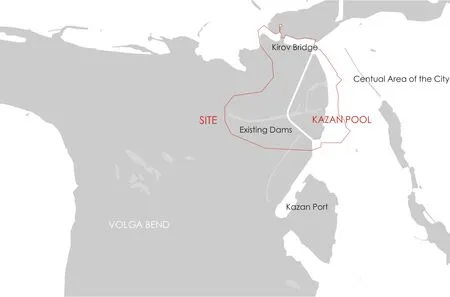
图1 / Figure 1区位 / Location

图2 / Figure 2剖面图 / Section
第三,针对地段东面岸上部分,“喀山池”方案优化滨水休闲道路,将跨过铁路和其他交通线路的东西向人行桥的数量增至7条,并在节点处建造了几个广场,如“喀山池”北广场、“喀山池”南广场和L型“喀山池”转折处的“喀山池”广场,不仅确保了“喀山池”的可达性,还创造了活跃的公共场所。总体上,在充分考虑现状的前提下,“喀山池”方案采用最小干扰的策略,通过少量公共空间设计,获得最大公共效益,实现生态岸线的目标。
在卫星地图上万能视角下,“喀山池”方案挖掘并呈现出伏尔加河湾喀山段优雅线性形式的潜在空间趋势(图9),这将是喀山城的新地标。
图片来源
Figure Sources
文中图片均为朱文一工作室提供
All fi gures are provided by ZHUWENYI Atelier www.zhuwenyi.com
FULL TEXTS TRANSLATED FROM CHINESE
The L-shaped “Kazan Pool” is 2.65 kmlong,located on the Volga Bend between Kazan Port and Kirov Bridge. It is naturally extended from the north area of Kazan Port and the west area of Kazan old city center (Figure 1).
First, the “Kazan Pool” is 20-30 m wide and consists of a 20m wide swimming pool with a walkway and 5m of elevators and decorative poles on each side. The “Kazan Pool” is divided into upper and lower fl oors, of which the upper level is 15m high, consisting of a swimming pool of 8-14m wide and a walkway of 3-6m wide; the lower level is 7m high and consists of two 4m bicycle lanes(Figure 2). In history, this area of water is not deep water area but the submerged area after the rise of the Volga River. This makes thousands of structural poles of the “Kazan Pool” very easy to achieve(Figure 3). It can accommodate thousands of people for swimming, walking, cycling and other recreational activities (Figure 4-7) .Second, together with the 2.55 km long waterfront recreation trail and its pedestrian bridge connecting the old city center, the “Kazan Pool” not only connects the Kirov Bridge and the Kazan Port from the water, but also highlights the advantages of the water landscape of the Volga Bend that has been hidden before (Figure 8).
Third, the “Kazan Pool” proposal reshapes the waterfront recreation trails, adding seven east-west footbridges that cross the railway and other transportation lines, and makes several squares at the nodes. In particular, the North Square, the South Square and the “Kazan Pool” Square at the turning point. City residents and visitors from the old city center can easily access to the water through the“Kazan Pool”, to enjoy the beautiful waterscape like in the new center at Kazan Port.
In brief, from God's-Eye-View on satllitte map, the“Kazan Pool” proposal reveals the potential spatial trend of the Volga Bend in its elegant linear form L-Shape. It would be a new landmark in Kazan City (Figure 9).
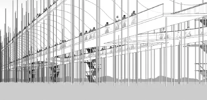
图3 / Figure 3开敞水面 / Open Water
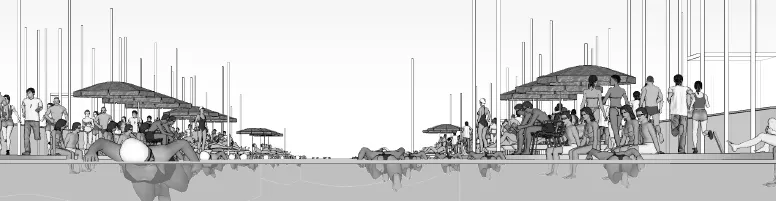
图4 / Figure 4游泳 / Swimming

图7 / Figure 7滨水美景 / A Beautiful Waterscape
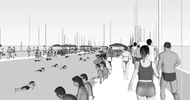
图5 / Figure 5快走 / Brisk Walking
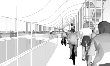
图6 / Figure 6骑自行车 / Bicycling
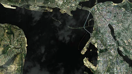
图8 / Figure 8喀山池方案整合周边空间 / Kazan Pool and Its Contexts

图9 / Figure 9喀山新地标 / A New Landmark in Kazan City
