芜湖市土地利用时空演变与生态敏感性分析
2023-08-26晋欢

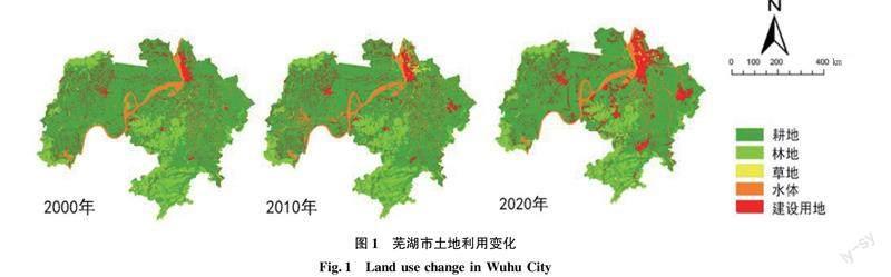

摘要 基于2000—2020年芜湖市土地利用数据,利用ArcGIS 10.7等软件分析芜湖市20年间土地利用变化,选取高程、坡度、坡向等8个单因子结合AHP层次分析法确定各单因子的权重并对研究区域生态敏感性进行加权叠加分析。结果表明,2000—2010年芜湖市土地利用情况发生较大变化,林地与耕地是减少较多的用地类型,大多转化为建设用地;林地转化为耕地、耕地转化为建设用地面积较多。景观格局指数表明人为干扰程度逐渐强烈,斑块数量逐渐减少,生物多样性降低,斑块之间分离度增加,形状指数降低。综合生态敏感性分区以中敏感为主,占整个研究区面积的53.82%。
关键词 土地利用;时空演变;生态敏感性;生态安全;芜湖市
中图分类号 X 171.1文献标识码 A文章编号 0517-6611(2023)15-0078-04
doi:10.3969/j.issn.0517-6611.2023.15.018
Analysis of Spatial-temporal Evolution and Ecological Sensitivity of Land Use in Wuhu City
JIN Huan
(Anhui Agricultural University, Hefei, Anhui 230000)
Abstract Based on the land use data of Wuhu City from 2000 to 2020, ArcGIS 10.7 and other software were used to analyze the land use change of Wuhu City in 20 years.Selecting 8 single factors such as elevation, slope and aspect, and combine them with the Analytic Hierarchy Process (AHP) to determine the weights of each single factor, and perform weighted overlay analysis on the ecological sensitivity of the study area.The results showed that the land use in Wuhu City had changed greatly from 2000 to 2010. Forest land and cultivated land were the types of land that had been reduced more, and most of them had been converted into construction land.The conversion of forest land into arable land and arable land into construction land were relatively large.The landscape pattern index indicated that the degree of human interference gradually intensified, the number of patches gradually decreased, biodiversity decreased, the degree of separation between patches increased, and the shape index decreased.The comprehensive ecological sensitivity zoning was mainly medium sensitive, accounting for 53.82% of the entire research area.
Key words Land use;Spatial-temporal evolution;Ecological sensitivity;Ecological security;Wuhu City
長江流域土地资源随着城市化快速发展,在重重挤压中面临着面积缩减、生物多样性降低、景观破碎度增加等问题[1-2]。2020年《长江保护法》出台后流域生态环境保护与修复引起广泛关注并成为周边城市近年来发展的核心,流域生态问题的修复与治理不仅需要单个片区的努力,也需要将整个流域体系看作一个整体,相互促进协同合作[3]。
目前许多学者利用GIS技术、ENVI软件等通过遥感影像的数据处理与空间分析对流域进行研究。汤佳等[4]基于FLUS模型对汨罗江流域土地利用变化情况进行分析,提出基于水安全的流域土地利用优化策略,推动流域尺度的可持续发展研究。尹剑等[5]利用MCE-CA-Markov模型分析和预测了皖江流域土地利用变化与景观格局。……