黄土丘陵区淤地坝作用下地下水位动态演化特征
2021-03-28白乐殷会娟李昭悦
白乐 殷会娟 李昭悦

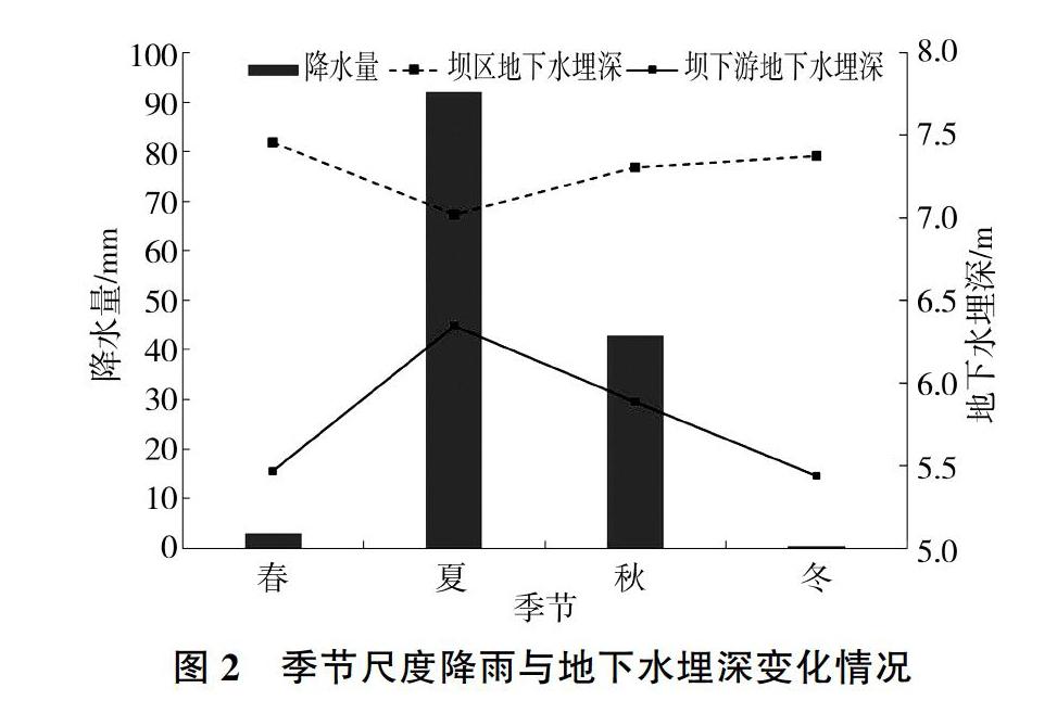
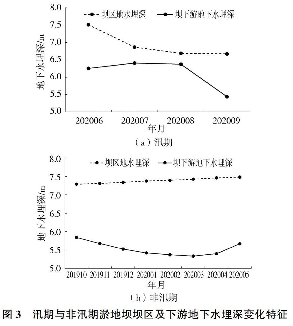
摘 要:以黄土丘陵区典型淤地坝刀劳庆骨干坝为例,采用野外原位观测及相关分析的方法,研究淤地坝作用下地下水位时空分布格局和动态演化特征,揭示上下游补排关系及驱动因素,为淤地坝坝区地下水资源保护与高效利用提供理论依据。结果表明:①淤地坝下游和坝区地下水位年最大变幅分别为1.82 m和1.27 m,坝下游地下水位整体呈下降趋势,而坝区内地下水位呈上升趋势;②淤地壩区和下游两观测点地面高差9 m,直线距离478 m,淤地坝地下水位比下游地下水位高7.51 m,淤地坝坝区内地下水补给坝下游地下水;③淤地坝下游地下水位变化具有明显的季节性,形成高峰(非雨季)与低谷(雨季),降雨补给地下水具有时滞性,坝内夏季地下水位上升、其他季节下降;④农业灌溉用水量增加是地下水位变化的重要驱动力,其对坝下游地下水位的影响大于坝区。
关键词:淤地坝;地下水位;降雨;动态演化特征;黄土丘陵区
Abstract:Taking Daolaoqing key dam of typical warping dam in loess hilly area as an example, the spatial and temporal distribution pattern and dynamic evolution characteristics of groundwater level under the action of warping dam were studied by field in-situ observation and correlation analysis. The relationship between upstream and downstream recharge and discharge and driving factors were revealed, which provided theoretical basis for the protection and efficient utilization of groundwater resources in warping dam area. The results show that a) the maximum variation of groundwater level in the downstream of the warping dam and the dam area is 1.82 m and 1.27 m respectively. The overall trend of the groundwater level in the downstream of the warping dam is downward and the groundwater level in the dam area has an upward tendency; b) the ground elevation difference between warping dam area and downstream two observation points is 9 m, straight line distance is 478 m, the groundwater level of warping dam is 7.51m higher than that of downstream water level and the groundwater of the dam area recharges the downstream groundwater; c) the variation of groundwater level in the downstream of warping dam has obvious seasonality, forming peak (non-rainy season) and trough (rainy season), and rainfall recharge groundwater has time delay. The groundwater level in spring and autumn of the dam falls in winter and rises in summer and; d) the increase of agricultural irrigation water consumption is an important driving force of groundwater level change and its influence to the groundwater level in dam area is not as good as that in downstream dam.
Key words: warping dam; groundwater level; rainfall; dynamic evolutionary characteristics;loess hilly region
淤地坝是黄土高原水土保持的关键措施,大规模淤地坝建设在发挥拦沙蓄水、调节径流[1-4]、改善生态环境等综合功能的同时,对地下水文循环产生了深刻影响,给地下水资源保护和生态治理带来新的挑战。地下水位是地下水循环的“脉搏”,是衡量区域地下水资源开发合理与否的重要判据。黄土高原水资源短缺、生态环境脆弱,大规模淤地坝建设对地下水位动态特征的影响,已逐步成为水文、环境、生态等学科研究的热点。……