成都地铁8号线一期地下水影响分析
2020-05-19徐瑞御魏镜玲肖庆峰
徐瑞御 魏镜玲 肖庆峰
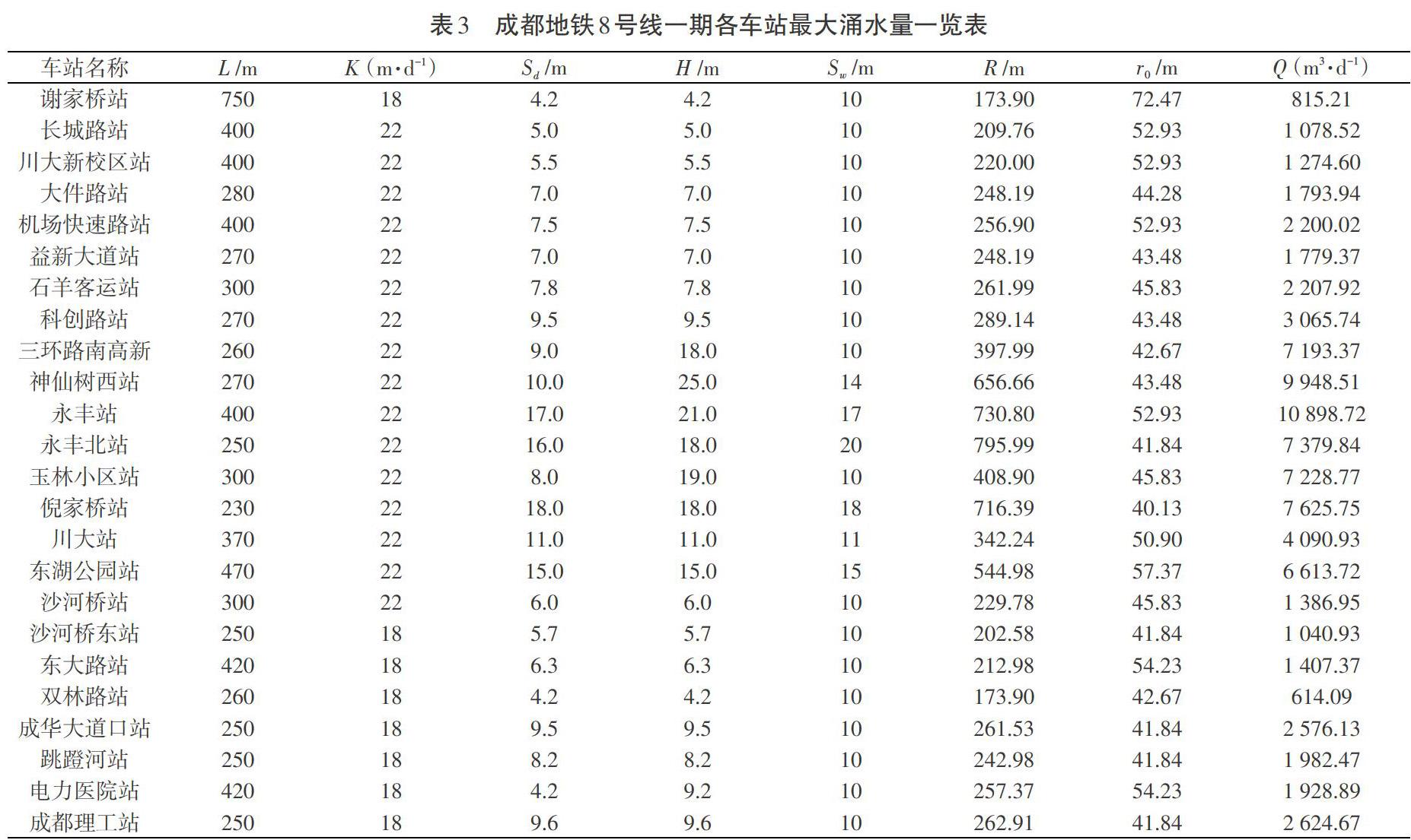


摘 要:成都地铁8号线一期线路呈西南~东北走向,南起谢家桥站,向东北方向串联十里店、万年场、玉双路、牛市口、东湖、倪家桥、肖家河等居住集中片区,建成后将有效改善城市交通状况。同时,地铁建设也会对城市地下水环境造成相应影响,例如,使地下水位壅高;由于疏排水引起地面不均匀沉降;地下水运动造成车站涌水等。本文通过计算得出:地铁8号线一期修建引起的各车站地下水位壅高值为0.010~0.546 m;车站基坑降水引起的地面沉降值为0.21~9.84 mm;車站的最大涌水量为614.09~10 898.72 m3/d。
关键词:成都地铁8号线一期;地下水壅高;地面沉降;最大涌水量
中图分类号:TU46,U453.6+1 文献标识码:A 文章编号:1003-5168(2020)07-0122-04
Abstract:The first phase of Chengdu Metro Line 8 runs from the southwest to the northeast, starting from Xiejiaqiao station in the south, connecting the northeast residential areas of Shilidian, Wannianchang, Yushuang Road, Niushikou, Donghu, Nijiaqiao and Xiaojiahe, When completed, the urban traffic condition will be effectively improved. In the meantime, the subway construction will have a corresponding impact on the urban groundwater environment, such as making the groundwater level rise; uneven ground settlement caused by drainage as a result water inflowing into the station, etc. In this paper , it was obtained by calculated that the backwater level of each station caused by the first phase construction of Metro Line 8 was 0.010~0.546 m, the ground settlement caused by the foundation pit dewatering was 0.21~9.84 mm, and the maximum water inflow of the station was 614.09~10 898.72 m3/d.
Keywords: the first phase of Chengdu Metro Line 8;groundwater backwater;land subsidence;maximum water inflow
随着城市规模的日益扩大,各大城市的交通压力陡然增加。成都地铁建设对改善和加强城市人防工程系统、提高城市交通通行能力、实现城市健康持续发展、推动和促进成都经济发展具有非常重要的意义。成都地铁远景规划线路总长约2 450 km,远期规划线路总长约1 765 km。目前,成都地铁共开通6条线路,线路总长196.477 km。随着地铁建设力度不断加大,在地铁建设过程中产生的环境地质问题备受重视。徐则民[1]、徐岩[2]、孙钧[3-5]、毛邦燕[6]、赵瑞[7]等人都对地铁建设中地下水的影响问题进行了研究。徐则民[1]、徐岩[2]、孙钧[3-5]从宏观上对这一问题进行了定性分析与评价,没有进行定量化研究。毛邦燕[6]、赵瑞[7]未考虑地铁建设中涌水量的计算。对地铁建设过程中地下水与工程建设的相互影响进行分析,可为相关研究提供帮助,并对相应工程建设提供参考,具有十分重要的理论和实践意义。……
