珠三角门户城市惠州和端州“山—湖—城—江”格局的形成机制
2019-12-02赵茜瑶林箐
赵茜瑶 林箐
中国传统山水城市中,形成“山—湖—城—江”结构的城市不在少数,并且以优美的湖山风光闻名于世。它们有的位于滨海冲积平原,有的位于深厚的堆积平原,在不同的自然地理条件中形成了相似的城市山水结构。其背后是顺应自然资源、因地制宜的城市营建传统的在地实践。同时也形成了独特的城市景观特色和完整的城市环境韧性系统。然而在当代中国的城市化进程中,自古以来形成的“十里不同风,百里不同俗”的独特城市风貌正逐渐淹没在全球化浪潮之中,趋同的城市建设方式和景观导致富有本土特色的城市生活无法有效开展而逐渐消失,自然环境遭到破坏,极端灾害频发。在这样的背景下,研究山水范式的地方实践,探索城市内外的自然系统如何通过山水营建联系起来,将为避免城市特色危机、保护城市生态环境、提升现代城市韧性带来一定的启发和指导。
不同于北方地区由于下游河流的频繁改道,城市往往选择在与大江大河有一定距离的地方建设,中国南方的城市与水系的关系往往更为亲近,城市常常直接临江而建[1]。珠江流域位于中国大陆南陲,由于特殊的地理、气候因素,在古代社会发展较晚。惠州与端州(现肇庆)作为古代珠江地区的重要府城,是珠江的主要支流东江和西江进入珠江三角洲的门户城市,具有分领广东东西二翼的重要战略位置。两座城市在古代开展城市建设的时间相对较早,并持续千年在相同城址进行城市建设,均形成了“山—湖—城—江”的山水结构,成为珠江三角洲地区重要的风景城市,具有较强的相似性(图1)。以往的研究往往从单一城市造景手法、审美意趣、水利和园林建设等角度出发,忽视了城市以及湖泊能够得以留存的原因和规律。通过分析研究历史上惠州与端州在城市选址和城市山水格局的建设过程,从珠三角区域的角度可以更深入地发掘古人在人居环境体系建设方面的创造性智慧。
1 区域条件与城市
1.1 珠三角地区的自然基底
惠州和端州所处的珠三角地区,处于地壳构造的沉降区,是海陆之间的过渡地带。其外围山丘环绕、众水汇流,堆积作用旺盛,形成了高度发育的三角洲景观。珠三角属南亚热带海洋性气候,雨量集中,降雨强度大,加之河流本身径流量大,洪水泛滥时有发生。自然条件下河流易发生决口,形成汊流,甚至使干流改道,形成河、涌综合交错的水域景观。洪水泛滥还造成自然堤;泥沙堆积,堤身加高,又可形成排水不良的堤后沼泽。因此防洪排涝成为泛滥平原生产生活的重要问题,也成为后期该地区人类生产建设活动的基础[2]。
1.2 区域地理条件与城市选址
惠州和端州城市建设的必要性主要是由区域自然地理条件影响下形成的门户地位所决定的。惠州“东距潮,西连广,比接赣,南极于海”(明·嘉靖《惠州府志》),恰好处于从珠江三角洲通向粤东莲花山脉南北两侧地区的“丫”字形路线的交叉点,可以联系广州和江西、福建,扼守广东东部[3]。这促使了惠州城的产生兴起以及长期处于地区行政中心的地位,并使之发展为粤东地区与珠江三角洲地区之间最为重要的人流、物流集散地。而顾祖禹在《方舆纪要》一书的肇庆府条目中之记述:“府带山控江,袤数千里,据广州之上游,当贺、梧之津要。”端州地处珠江三角洲西缘,扼西江的总口,北面可溯西江支流桂江、贺江等,越过南岭可接潇湘,通达长江流域,南有新兴江及陆道可至高州、雷州等地[4]。实为两广之间的咽喉,广州西面之屏障。不仅为政治、军事重镇,而且是西江流域水运枢纽和经济中心(图2)。
惠州和端州城市的自身选址则体现了对区域自然环境和门户城市需求的准确判断,具体体现在以下几方面。
1)河流改道。依水而建的城市,河流的变迁将直接影响城址的选择。据学者考证[5],宋代以前,惠州地区的东江及其支流西枝江周边尚有明显的河流三角洲地貌景观,东江河道发生过数次摆动,惠州古城的位置也随之发生了4次移动。宋代以后,随着对东江地区的开发程度增大,“围堤兴筑”带来农业的繁荣。人工围垦促使东江下游三角洲放射状的水道系统成为单一正干流道,直接限制了东江河道的自然摆动,府城的选址也自此没有再发生过改变(图3)。端州城址处于西江故道和西江之间的高地上,同样也是应对水流量极大的西江水患风险的选择。
2)交通商贸需求。河流走廊往往是天然的水陆交通廊道。唐宋时期,由于广州在全国中外贸易中的地位不断上升,由广州输入的商品需要向北运输,加之国家政治中心向南移动,广东地区的交通线地位更显重要。惠州、端州分别扼守进出广州的东、西要道,出于对往来的船舶和陆上商队的管理以及进出口货物的转运等方面的需求,沿江设置具备政治、经济中心性质的州城十分必要。
3)城市安全。由于远离中央政权又濒临大江,军事防御和防洪是城市安全重点考虑的方面。惠州府城选址在两江交汇处,于此地设城,便于扼控水陆交通的要冲之地。在城西的山前湖泊(后演变为西湖),水面浩大,与两江一道将城环抱,易守难攻。经过人工筑堤拦水和疏浚改造,湖泊也发挥着水柜作用,承接山前汇水的同时也起着调蓄东江水量、排水排洪的功用,保护城市安全[6]。在端州,古人却未似惠州一般选择距端州不远的北江和西江汇流之处建城。原因是此地虽有交通之利,但周边毫无屏障且两江汇合,水患威胁严重。而端州所在之处三榕峡、大鼎峡、羚羊峡由西至东把守西江咽喉,北有水泽和高山为障,这使端州成为天然易守难攻之地,又能借西江之便。
1.3 区域条件对“山—湖—城—江”格局形成的影响
优良的区域地理位置使得城市具备优先发展物质经济,进行城市营建的可能。两城分扼东江、西江总口,是珠三角腹地进入粤东地区和粤西地区的门户,战略位置重要,在历史上均长期被统治阶级当作地方中心[7],在发展上处于区域的前列。此外出于战略防御目的对要塞城市的建设倾斜和士大夫官员的派遣等,也推动了城市发展和风景营建。
而城市自身选址,则受中国古代建城勘察相地的“形胜”思想影响,使之具备了各个山水要素和营建山水城市的便利条件。两城选址周边均具备背山面水的自然山水格局,并且在山与城之间均有大片水泽作为后期形成湖泊的基础自然条件。惠州和端州均紧靠江水,表现出极强的亲水性,这一现象在中国其他的大江大河是不多见的,形成了珠江流域传统山水城市的特色。选址一方面充分利用了江、湖作为城市的防御屏障和基础设施,另一方面也面临着较高的洪水风险,因此城市营建需要通过整理水系、发展湖泊和防洪堤防措施提升城市安全,在天然的山水结构上最终形成城湖相依的山水城市环境。
2 “山—湖—城—江”格局的形成
2.1 城湖一体的惠州府城
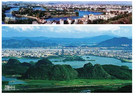
1 现代惠州和端州的城市山水风景Urban landscape of modern Huizhou and Duanzhou
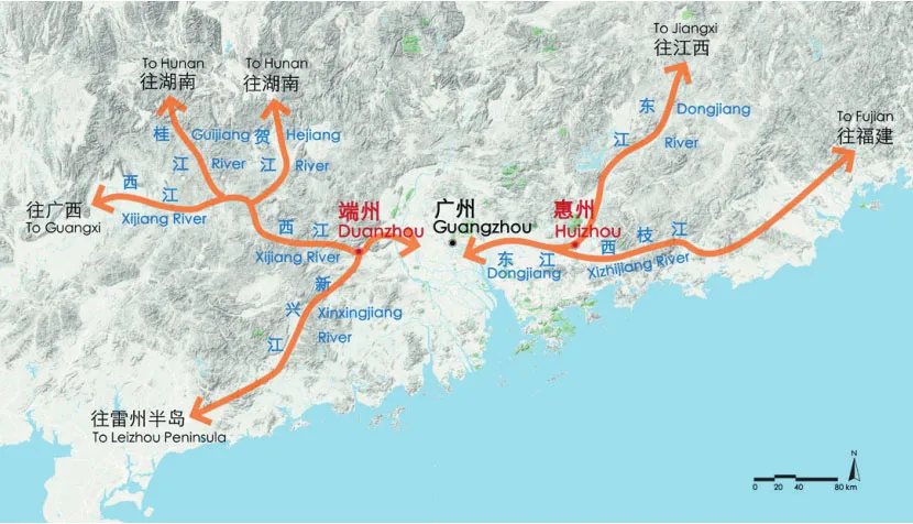
2 惠州和端州的区域地理条件Regional geographical conditions of Huizhou and Duanzhou
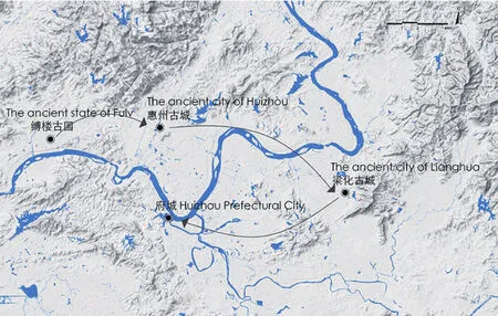
3 惠州城市选址变迁Change process of Huizhou city site selection
惠州西湖因位于城西而得名,其形成是自然和人工共同作用的结果。据《惠州西湖志》记载,大约于东晋年间,受东江自然堤的阻拦,东江泛滥的洪水、西面山地的汇水和山中涌泉在东江之南和西枝江之西的低洼地汇聚形成湖面。由于自然堤时决时成,湖泊难以常年保持稳定水位,常常处于一时丰盈一时干涸的状态,直到宋时筑堤拦蓄湖水,才成为经常性湖泊。西湖能维持至今,离不开历代的修堤蓄水。建造与维护惠州西湖的活动与惠州城市的韧性发展息息相关,主要体现在以下几个方面。
1)保障城市安全是西湖进行水利开发的首要动因。惠州自古是兵家必争之地,西湖和东江、西枝江一起让城市几乎四面环水,易守难攻。为了守住这道防卫屏障,历朝历代的地方官员均很重视西湖湖水的集蓄。惠州府城建于山、江之间,春夏汛期会受到山洪和江水暴涨的威胁。西湖的存在,可对洪水起到调节作用,保护府城安全。西湖主要通过拱北堤、碧水关、南隐堤3处水利设施进行洪水的调节,并与堤、闸、城墙、渠道等工程构筑物一起形成一个可蓄可泄且具有防洪效益的城市水利工程系统,维护城市韧性发展。
2)惠州府城城市的营建和西湖的开发是相互推进的,城市发展加速了对西湖的开发利用,西湖的存在也深刻影响了惠州府城的空间形态发展。西湖水量丰沛,水域广阔,“溉田数百顷,苇藕蒲渔之利,岁数万”(民国 《惠州西湖志》),促进了惠州小农经济的发展,城市人口不断增加。随着淡水需求加大,明初时在扩建城池时将一部分西湖水引入城内,又因筑城开凿了一些地方,共同形成百官池(鹅湖)。西湖水在此池经过停蓄澄清后作为水源供官民使用,再通过碧水关排入江内,并与城内其他排水沟渠一道为城市泄洪排水和防火功能服务。
3)宋时的惠州府城面积尚小,城市与湖并未直接接壤。但此时惠州经济发展迅速,在规模开发下,西湖已成为承担惠州府城水利、游赏与文化的一处重要水体。在明清时期由于城市进一步发展扩张,逐渐形成与江湖水岸形态紧密贴合的城市形态。这一形态还让惠州得名鹅城,沿用至今。但随着人口不断增长,府城附近用地紧张,大约自明代起,出现了与湖争地的情况,占湖为屋为田的现象时有发生。为了维护西湖,当地官员自宋至民国时期组织了多次修缮和疏浚,重视对改造、化育后的“人工自然”精心照顾,制定相应禁令和管理制度。这才使得西湖不至于堙废成田,鹅湖不致淤为平地,才能历经千年持续发挥多种效益(图4)。
4)古代惠州的历代官员和居民在对西湖进行水利和农业生产开发的同时,也发掘了其风景资源价值。西湖周边最早的风景建设可以追溯到传说中东汉的伏虎台和晋代的龙兴寺、唐代的泗州塔等佛教建筑的兴筑。宋代开始通过筑堤拦湖形成常年湖泊后,风景建设的理水通过水利、交通和城防工程的建设形成的堤网系统得以完成[8],形成水面丰盈、湖山相映、水光接天、幽深旷朗的自然格局。宋以后文人士大夫或直接参与西湖的建设或游历题咏,带来文人写意的内涵与风格,“苎萝西子”的景观逐渐形成。
惠州是目前有文献可考的珠三角地区最早具有城市“八景”的州府城市。北宋惠州郡守陈称“筑堤扞江,以全西湖”(明·《明一统志》),使西湖得以成湖,惠州的渔业、农业得到极大发展。西湖的整治工程经验和官员本身的审美文化修养,使郡守具备高度概括惠州景观的能力。他题写的北宋八景囊括东江、西湖以及西湖水源地的关键之处,一半集中于西湖,一半集中在外部的江山胜景,将西湖与府城圈定其中,呈现出田园湖山城市的特色。此后,府城的品题数量不断增加,至民国时期张友任撰写《惠州西湖志》时扩展为十七景,并始终保持以湖山风光为主的特色。通过不断的人工建设和诗词唱咏,共同将湖山与诗文关联化,使惠州始终保持着湖城交融的城市特色(图5)[9]。
2.2 端州府城与星湖
星湖旧称沥水,原是西江故道旱峡在北岭山下形成的一片水乡泽国。古代西江发洪水的时候,当上游洪峰到达肇庆段时,由于羚羊峡处西江河道突然收窄,使得西江分流一支在龟顶山北面进入旱峡,后在羚山附近分3支汇入西江。随着岭南地区在宋代的大发展,出于保护生产生活安全和获取可利用土地的目的,人们对这一地区开始进行人工整理,最终在城市以北形成大型湖泊。
星湖所处的这片水域最初对于端州府城的作用主要在于行洪排涝,影响城址的选择。根据文献记载“两水夹州,则西江势分,无泛滥之患,形势更宜”(清·李调元《南越笔记》)。因此端州府城建设在一小山冈之上,利用二水分流减轻城市排洪压力,减少洪涝灾害发生。但是“端郡东北附郭,田数百顷,诸水汇于沥湖,春夏水溢,则田胥没。”(清《宣统高要县治》)为了保障城市周边农业生产的安全,历代官民对沥水进行多次治理,修后沥水、跃龙窦、新沥等水道引导沥水入西江。并在城外自三榕峡至羚羊峡修筑堤围,防止西江重新进入旧河道引发洪涝[10]。积水基本排走的同时,西江也被固定在南边的水道,进而出现大片适宜耕种的土地。

4 惠州府城和惠州西湖的营建过程The construction process of Huizhou city and the West Lake
古代肇庆地区山民、疍民及少数民族较多,动乱频繁。平原风貌的变化和维持社会稳定的需要促使府城城池开始建设,自宋起经过历代的不断修葺,形成尤为高大坚固的城墙,在军事防御和抵御洪水方面多次发挥重要作用,并因其防洪方面的突出功用被保留至今。端州府城城池呈较为规整的长方形,沿西江方向为长轴,顺应河流的形态。城外沿城墙在城的东、西、北三侧挖掘城濠,并通过水门与城内的上下濠相连通。城濠体系通过与西江水系及沥湖联通,形成一套具有调蓄功能的城市水系。城内水面的分布与城内的功能布置相联系,发挥着军队官船停泊、生活用水供应、防火等多方面的功能[11]。
西江流域鱼类资源丰富,端州地区自唐代起利用近水之便,开始塘鱼生产,并经西江水运对外销售。宋代随着广东地区的大开发,此地开始兴修水利,开渠筑池,排水造田。通过将洼地㙟田筑成鱼塘,种植蒲草等水生经济作物,肇庆平原的自然风貌逐步发生改变。明清时期延续了农耕的传统,沥湖周边始终一片田园景象。鱼塘水田的格局为日后沥湖扩大,提供了便利条件。但到清晚期和民国时期,沥湖逐渐失修,淤积为田塘,水面急剧缩小,“仅一渠流经岩前,强名为湖”(《民国高要县志》),排水的渠涌淤塞,致使涝灾严重。新中国成立以后通过水库工程将原来涝患严重的部分低产田和㙟塘联成互相连通的6个湖面,用于蓄纳径流、消纳洪水和灌溉,最终形成星湖(图6)。
星湖附近最重要的景观是七星岩,因7座形态各异的石灰岩山峰立于湖中而闻名。七星岩虽距离端州府城数里,但秀美的风光使人们很早就认识到这几座孤峰的风景价值,将之比作嵩台蓬莱。早在晋代七星岩便见于文字记录,历代文人骚客留下不少诗句文章。对于七星岩的开发建设,除了石刻较早出现,整体基本以保持自然天成的景色为主。历代官员均十分重视对七星岩的保护,多次颁布禁止开发采石的禁令。随着肇庆地区宗教文化的兴盛,七星岩内开始建设寺庙以及若干园林建筑,以明代最盛。在民国时期曾成立“七星岩公园会”主持公园建设工作,但工程中辍[12]。新中国后建成星湖后,成立广东地区首个国家级风景名胜区。
端州四面环山,地理位置险要,明初出现的初版八景以四周山体景致为主,反映了端州作为区域重镇注重选址布局的整体意识。在洪水威胁和军事防御的需求下,城防工程和水利设施的建设成为历代城市管理者的重点事务,因此后续的八景中出现水利和城防景观。“包井冰清”“沥湖返棹”等被列入端州八景。此后随着佛教的兴盛以及七星岩和鼎湖山等的陆续发现和整理,人工构筑的占比逐渐加大(图7)。
2.3 两城 “山—湖—城—江”格局的形成特色
2.3.1 “山—湖—城—江”的山水格局
惠州和端州的山水格局均是在天然山水结构下经过人工修缮形成的,天然山水结构的特点是湖泊形成和城市营建选址的前提,决定惠州自西向东形成了“山—湖—城—江”的景观序列,而在端州这一序列转变为自北向南,进而影响了城市的空间形态。惠州府城受制于水域岸线和有限的土地,形成了纺锤形、南北为长轴的城市形态,城市与自然山水之间贴合紧密。而端州由于西江北岸土地面积大,城市形态受制于自然条件的情况少,可以形成规整的城池,但仍呈现沿江发展的特点(图8)。
2.3.2 人工与自然结合的湖泊发展历程
古代中国的城市离不开农耕和水利建设的基础,西湖始于蓄水,沥湖始于排水,但其本质均是为了整理土地以用于农业和城市开发。两城均建设了以城内濠池与城外湖泊为主,与江相连的城市水系。对于滨水城市的城市安全和可持续发展具有重要的作用,促进了山、水、城一体的空间结构形成。作为城市的支撑系统,一定程度上保证了惠州和端州在中国古代能够在水文条件复杂多变的珠江三角洲地带长期稳定发展。两座城市将水系建设与城市风景开发融为一体,经过历代的疏浚整治和修建整理,在满足水利需求的同时创造出闻名天下的湖光胜景,风景建设过程在时空分布上虽然存在较大差异,但是其背后营建山水城市的思路是一致的。
2.3.3 城市景观特色的塑造
惠州和端州作为古代珠江三角洲区域除广州外的2个区域文化的核心城市,较早出现了“城市八景”。2个府城均有大型江湖山水湿地相伴,八景的变化可以反映城乡物理环境的变化和审美诉求的变迁。通过对比两城的八景内容可见,两城虽具有相似的湖山结构,但是基于两地不同的自然地理特色和人文底蕴,形成的八景具有不同的特色。惠州八景中城湖一体的特色始终如一,而端州则经历了由展现地方形胜向关注人工构筑转变的过程。两城在风景集称上的差异,反映出地方文化在城市山水体系建设中的作用。
3 结语
惠州和端州两座府城在历史长河中逐渐形成具备湖山结构的临江山水城市,城市的人工环境和自然环境通过古人传统的空间规划策略和工程建设紧密地结合在一起。其本质是基于城市所在区域的地理条件进行的人工干预和水文梳理的过程[13]。通过改造自然、发展农业培育土地、建设抵御灾害的安全支撑体系等方式形成了山、湖、城、江一体的景观系统,满足了古人的生存需要,也承载了古人对生活的艺术追求[14]。时至今日,惠州和肇庆均面临着老城区建设饱和、山体破坏、水系统失衡的问题,原本和谐的山水城市面临严峻挑战。作为著名的山水城市,湖山范式在珠江流域的代表实践,虽然这两座城市的传统城湖关系早已发生改变,但在珠江三角洲地区快速城市化的今天,两城所代表的传统城市设计,对于提升三角洲城市韧性,增强城市的可持续发展依然有较为重要的现实意义。可以得到以下3方面的启示。
1)空间上,对于三角洲地区的城市来说,水系是城市空间的重要组成部分,是联系城市内外的自然系统的重要结构。城市空间发展应该注意保障对城市具有重要功能价值的蓝绿系统,与河流、湖泊的动态水文过程相协调,才能增强城市自然系统的承灾韧性。
2)时间上,三角洲城市往往具有很强的亲水性,在滨水空间积累了深厚的城市历史文脉信息。城水之间的互动关系应该得到合理的引导发展,通过整合滨水空间的自然和人文价值来适应城市未来的发展方向。
3)功能上,对于具有优美山水结构的城市,山水环境的生态功能和美学功能目标应转化为城市发展的空间约束,制定合理的土地开发计划。充分发挥城市山水格局系统的环境、经济和社会等综合效益。
图片来源:
图1中端州照片引自http://www.chinadaily.com.cn/m/guang dong/zhaoqing/2011-06/14/content_12689952.htm,惠州照片由暖木先生提供;图2根据谷歌地图绘制;图3根据参考文献[5]绘制;图4据《惠州西湖志》《惠州市城市建设志》相关图纸推测改绘;图 5、7 据参考文献[9]绘制;图6据《高要县志》《肇庆府属基围图》《端州区水利志》相关图纸推测改绘。
Among traditional Chinese landscape cities,there are a great deal that have developed under the structure of “mountain-lake-city-river”, and become world-renowned for the beautiful scenery of lakes and mountains, some of which are located in the coastal alluvial plains, some of which are located in the thick accumulational plains. These cities take shape of a similar urban landscape structure, as a result of adjusting to the nature law and following the local conditions, gradually developing a unique urban landscape feature and a complete urban environmental resilience system,however, the tide of globalization is gradually encroaching on the unique urban style featured in ancient times. The local characteristics of urban life can not be effectively carried out and are gradually disappearing in the convergence of urban construction methods and landscapes. A series of problems such as frequent extreme disasters and damaged natural environment, has made the further research on realization of landscape model and the exploration on how to build the natural system by connecting the water and mountain inside and outside city more significant, for avoiding the city crisis, protecting the ecological environment and increasing the city resilience.
Different from the frequent diversion of downstream rivers in northern areas, cities in southern China often have a closer relationship with the water systems so that cities are often built directly by rivers[1]. Huizhou and Duanzhou (now called Zhaoqing) are significant capital cities in the ancient Pearl River region, and the gateway cities of the main tributaries of the Pearl River,taking a significant strategic position to separate the east and west wings of Guangdong. The two cities have formed a “mountain-lake-city-river”landscape structure, becoming an important scenic city in the Pearl River Delta region, with strong similarity (Fig. 1). Previous studies often start from the perspective of single-city landscape-making,aesthetic interest, water conservancy and garden construction, ignoring the reasons and laws that cities and lakes can be preserved. Through the analysis of Huizhou and Duanzhou’s historical urban site selection and construction process of urban landscape pattern, it can deeply explore the creative wisdom of the ancients in the construction of the human settlements environment system from the perspective of special regions.
1 Regional Conditions and Cities
1.1 Natural Bases of Pearl River Delta Region
Huizhou and Duanzhou in the Pearl River Delta region are located in a subsidence area of crustal structure, which is a transitional zone between land and sea. Its peripheral hills surround, the flow of water, the accumulation of strong help to form a highly developed delta landscape. Under natural conditions, rivers are prone to burst, forming branch flows, even diverting the main stream, forming a water landscape with integrated crisscross of rivers and streams. Flooding also caused natural dikes, the accumulation of the sediment and the heightening of embankment formed the poorly drained embankment marshes, all which make flood control and drainage raise become a significant issue of production and life in the region, also turning into the foundation of human production and construction activities in the area in the later period[2].
1.2 Regional Geographical Conditions and Urban Location
The necessity of urban construction in Huizhou and Duanzhou is mainly decided by the gateway status formed under the influence of regional natural geographical conditions. Huizhou is just in the “Ya”glyph route intersection from the Pearl River Delta to the north and south sides of the Lianhua Mountains,which can contact Guangzhou and Jiangxi, Fujian,holding the eastern of Guangdong[3], Duanzhou is located in the western edge of the Pearl River Delta,the main mouth of the Xijiang River. In the north,it can be connected to Hunan across the Nanling to the Yangtze River basin. In the south it can go to Gaozhou, Leizhou and other places (Fig. 2)[4].
The location of Huizhou and Duanzhou cities shows the precise judgment of the requirements of the natural environment and gateway cities in the region,reflecting in the following aspects.
1) river diversion. For cities built on water,the change of river will directly affect the choice of city site. Based on the research by scholars, before the Song Dynasty, the Dongjiang River in Huizhou region had several swings, while the position of Huizhou ancient city also changed four times. After the Song Dynasty, with the increase exploitation of Dongjiang area, artificial reclamation has changed delta radial delta waterway system of the lower reaches of the Dongjiang River into a single positive main flow channel, directly limiting the natural swing of Dongjiang River. Since then, the location of the capital city has not changed (Fig. 3)[5]. Located in the highland between the old road of Xijiang River and the Xijiang River, the Duanzhou site is also the good choice to deal with the risk of flooding in the Xijiang River with great water flow.

5 惠州历代“城市八景”的空间分布The spatial distribution of “Huizhou Eight Scenes” in past dynasties
2) traffic trade needs. In general, river corridors are natural land and water corridors. During the Tang and Song Dynasties, Guangdong’s traffic line position became even more significant as trade activities in Guangzhou was flourishing and the political center moved to the south. Huizhou and Duanzhou respectively hold the east and west routes in and out of Guangzhou, for the sake of requirements in the aspects of the management of transport ships and land caravans to import and export of goods, it is necessary to set up state towns with the political and economic center along the river.
3) city safety. Since it is far away from the central government and on the verge of the great river, military defense and flood control are the key considerations for urban safety. The capital of Huizhou is located at the junction of the two rivers, convenient to control the land and water transportation. In the lake front of mountain (later becoming the West Lake), the water is huge with the two rivers together around the city, which is easy to defend and difficult to attack. While receiving water from the front of the mountain after the artificial embanking and dredging, it also plays a role of regulating the quantity of Dongjiang River water and discharging water to protect the city’s safety[6].Different with Huizhou, the ancients in Duanzhou didn’t choose the Beijiang River and Xijiang River flow to build the city near to Duanzhou. The reason is that though this place has the traffic advantages,there is no barrier around it and the two rivers meet,leading to the serious threat of flooding. Sanrong Gorge, Dading Gorge, Lingyang Gorge, where Duanzhou located in, could guard the throat of the Xijiang River from west to east, with waters and high mountains in the north as barriers. It not only makes Duanzhou a natural place which is easy to defend and difficult to attack, but also takes advantage of the Xijiang River.
1.3 The Influence of Regional Conditions on the Formation of the “Mountain-Lake-City-River” Pattern
With excellent regional geographical location,cities have the possibilities to give priority to the development of material economy and construction of the urban. The two cities are the gateway to the eastern and western regions of the Pearl River Delta,occupying an important strategic[4,7]. Moreover,strategic defense of the fortress city’s construction tilt and the dispatch of literati and officials also promoted urban development and scenic construction.
Huizhou and Duanzhou are close to the river water and strongly water-friendly, and both of them have the advantages of fronting water and with hills on their back, a large scale of water to develop the lakes between the mountains and cities, which is rare in other large rivers in China, taking the shape of the Pearl River basin traditional landscape city characteristics. On the opposite of these advantages,the site selection also faces high flood risks, therefore,the city construction needs to improve the city’s safety through arranging water systems, developing lakes and flood control embankments, which finally forms a mountain-water city environment with city-lake dependency on the natural landscape structure.

6 端州府城和端州星湖的营建过程The construction process of Duanzhou city and the Star Lake
2 The Formation of the “Mountain-Lake-City-River” Pattern
2.1 The Capital of Huizhou with City and Lake
According to theHuizhou records of the West Lake, around the East Jin Dynasty, the natural embankment, the flood of the Dongjiang River, the gathering water in the western mountain and the mountain surge spring converged to form a lake.The lake is difficult to maintain a stable water level all year round, which is often in a timely abundance or dry hole state. It is not become a regular lake until building the embankment to block the lake in the Song Dynasty. The construction and maintenance of Huizhou West Lake is closely related to the development of resilience in Huizhou city, mainly reflected in the following aspects.
1) ensuring the safety of the city is the primary motivation for water conservancy development in West Lake. For the sake of keeping this defensive barrier, local officials of all dynasties laid stress on the water storage of the West Lake. Huizhou was built between mountains and rivers, which will be threatened by flash floods and surging river water in spring and summer. The West Lake can play a role in regulating the flood and protecting the safety of the city. West Lake has considerable flood control benefits together with engineering structures such as dikes,gates, city walls and channels, and thus maintaining the toughness of urban development.
2) mutual promotion of the construction of Huizhou’s capital and the development of the West Lake. The development of the city speeds up the utilization of the West Lake, while the West Lake also profoundly affects the development of the space form of Huizhou’s capital. As the demand for fresh water increased, part of the West Lake water was introduced into the city during the expansion of the city at the beginning of the Ming Dynasty. Some places were excavated in the shape of the Baiguan Pool (Goose Lake). West Lake water is used as a water source for government officials and citizens and serving for the city’s flood discharge, drainage and fire prevention functions together with other drainage ditches in the city.
3) During the Song Dynasty, Huizhou was still a small region that was not directly adjacent to the lake,however, the rapid economy increase prompted the large development, and the West Lake has become an important water body for water conservancy,sightseeing and culture of Huizhou’s capital. During the Ming and Qing Dynasties, it gradually formed a city closely suited to the coastal pattern of the river and lake for the sake of the further development and expansion of the city. For the sake of maintaining the West Lake, local officials organized a number of repair and dredging from the Song Dynasty to the Republic of China, putting stress on the transformation, education after the “artificial nature” of careful care, formulating the development of the corresponding prohibition and management system (Fig. 4).
4) Officials and residents of ancient Huizhou discovered the value of scenic resources while developing water conservancy and agricultural production in the West Lake. Since the Song Dynasty, the water management system for landscape construction has been completed through the dike network system formed by the construction of water conservancy,transportation and urban defense projects. Scholars and officialdom either directly took part in the construction of the West Lake or the theme of traveling, bringing the connotation and style of scholar free brushwork[8].
Huizhou is the earliest capital city in the Pearl River Delta region with “eight scenic” reputation,which is currently available for examination. The eight scenic spots in the Northern Song Dynasty included the key points: half in the West Lake, half in the scenic outdoors of Dongjiang River, the West Lake and the West Lake’s water sources, expressing the characteristics of pastoral lake and mountain city. Since then, the number of titles in capital city has been increasing. By the time of the Republic of China,Huizhou records of the West Lakewritten by Zhang Youren, expanded to 17 scenes, which has always maintained its feature with lake and mountain scenery as the main parts (Fig. 5)[9].
2.2 Duanzhou’s Capital and Star Lake
Star Lake, formerly known as Lishui, was originally a land of rivers and lakes formed under Beiling Mountain by Hanxia, the old route of Xijiang River. With the great development of Lingnan areas in the Song Dynasty, people began to organize manually the waters for the sake of protecting production and living safety and acquiring usable land, eventually forming a large lake to the north of the city.

7 端州历代景观集称的空间分布The spatial distribution of Duanzhou landscape in past dynaties
The water area where Star Lake is located in,was initially served as flood discharge, drainage and site selection for Duanzhou’s capital. For the sake of keeping the safety of agricultural production around the city, officials and people of the past dynasties governed the drain water many times. After the repairment, the Lishui River was led into the Xijiang River through the Houlishui River, the Yuelong Dou River, the Xinli River and other waterways. In addition, a causeway was built outside the city from Sanrong Gorge to Lingyang Gorge to prevent the Xijiang River from re-entering the old river channel and causing flooding[10].
The change of plain style and the need to maintain social stability prompted the construction of the capital city pool. Since the Song Dynasty, through the continuous repair of the past generations, it has formed the particularly tall and strong wall, which played a significant role in the military defense and flood protection. The city wall system was connected with Li Lake by the Xijiang River water system, forming a set of urban water system with storage function, which plays a role in the parking of military official ships, water for life,fire prevention and other functions[11].
With the development of Guangdong in the Song Dynasty, the area began to build water conservancy, open canals to build ponds, drain water to build fields. The pattern of fish pond water fields are conducive to for the expansion of the Li Lake in the future, however, the lake gradually fell into disrepair in the late Qing Dynasty and the Republic of China. The silt was derelict into a field pond, and the water surface narrowed sharply. After the establishment of the People’s Republic of China, the original flood-stricken parts of the low-yielding fields and Tongtang were connected to six lake surfaces through the reservoir project for storing runoff, reducing flooding and irrigation, which finally formed the Star Lake (Fig. 6).
The most significant landscape near Star Lake is the Seven Star Cave, which is well-known for its seven limestone peaks with various shapes. With the prosperity of religious culture in Zhaoqing area, Seven Star Cave began to construct temples and several garden buildings, most prosperous in Ming Dynasty.During the Republic of China, the “Seven Star Cave Park Club” was set up to preside over the construction of the park, but the project was interrupted[12]. After the founding of the People’s Republic of China,Xinghu Lake was completed, and it is famous as the first national scenic spot in Guangdong Province.
The first eight scenes in the early Ming Dynasty were mainly surrounded by mountain scenery, reflecting that Duanzhou lays stress on the overall awareness of site selection and layout as an important regional city. With the threat of flood and the demand of military defense, the construction of the city defense project and water conservancy facilities were the key affairs of city managers in past dynasties, which appeared in the following eight scenes. Since then, with the prosperity of Buddhism and the discovery and arrangement of Seven Star Cave and Dinghushan Mt, the proportion of artificial constructions is gradually increasing (Fig. 7).
2.3 The Formation Features of the “Mountain-Lake-City-River” Pattern in the Two Cities
2.3.1 The Formation of the “Mountain-Lake-City-River” Pattern
The natural landscape structure in Duanzhou and Huizhou is characterized by the premise of lake formation and urban construction site selection,determining that Huizhou has formed a landscape sequence of “mountain-lake-city-river” from west to east. However, this sequence has changed to from north to south in Duanzhou and further has affected the spatial form of the city. Under the control of the water shore line and limited land, the capital of Huizhou takes the shape of the city form with spindleshaped, north-south long axis, leaving the water and mountain close to the city. Due to the large land area on the north bank of the Xijiang River, the urban form is not strictly affected by the natural conditions,which can form a well-regulated city pool, however,Duanzhou still presents the characteristics of the development along the river (Fig. 8).
2.3.2 The Combination of Man-made and Nature Lake Development

8 惠州和端州的“山—湖—城—江”格局Huizhou and Duanzhou’s “mountain - lake - city - river” pattern
Cities in ancient China could not be separated from the foundation of farming and water conservancy construction. The West Lake began to store water and the Li Lake started to drain water, however, its essence is to organize land for agricultural and urban development. Both cities have built urban water systems that are mainly connected to the city’s puddly and out-of-town lakes, which plays a significant role in the urban safety and sustainable development of waterfront cities, promotes the formation of a spatial structure integrating mountain, water and city. As the support system of the city, it guarantees the long-term stable development of Huizhou and Duanzhou in ancient China in the Pearl delta with complex and variable hydrological conditions to some extent.Through dredging, renovation and construction of past dynasties, they have created world-famous lake scenery while conforming to water demand. Though there are huge differences in time and space during the scenery construction, it shares the thinking mode of building landscape city.
2.3.3 Shaping the Unique Urban Landscape
Duanzhou and Huizhou are considered as the key cultural cities in ancient Pearl Delta Region apart from Guangzhou, where and the eight scenery appeared early. The changes of the eight scenery can reflect the changes in the physical environment and aesthetic demands of urban and rural areas.Compared with the eight scenery of the two cities,it can be seen that although there are similar lake and mountain structure, the eight scenery has own unique characteristics on the basis of the different natural geographical characteristics and humanistic background of the two places. The city-lake integration of Huizhou eight scenery has been consistent from beginning to end. However,Zhaoqing has experienced from the display of local success to the artificial construction process.
3 Conclusions
Huizhou and Duanzhou have become the landscape cities alongside the river, and the artificial environment and natural environment of the city are closely connected through the traditional spatial planning strategy and engineering construction of the ancients, as a result of nature transformation, a safe supportive system building to resist disasters,agriculture development to cultivate land, formation of the humanized nature[13]. Although the traditional city-lake relationship between the two cities has changed for a long time, the traditional urban design represented by the two cities is still of great practical significance for improving the resilience of the delta cities and enhancing the sustainable development of the cities in today’s rapid urbanization in the Pearl River Delta region.
In terms of space, water system is an important part of urban space for cities in the delta region, a significant structure of natural systems connecting with inside and outside the city. The development of urban space should lay stress on the protection of the blue-green system which has significant functional value to the city, coordinating with the dynamic hydrological process of rivers and lakes, and thus enhancing the disaster resilience of urban natural system.
In terms of time, delta cities often have a strong hydrophilic character, and have accumulated a profound historical context of the city information in the waterfront space. The interaction between the city and the water should be reasonably guided and developed to adapt to the future development direction of the city by integrating the natural and human values of the waterfront space.
In terms of function, the ecological function and aesthetic function objectives of the landscape environment should be transformed into spatial constraints of urban development for cities with beautiful landscape structure to formulate a reasonable land development plan. It will take full advantages of the comprehensive benefits of environmental, economic and social benefits of urban landscape pattern system.
Sources of Figures:
Fig.1 city of Huizhou is quoted from Mr. Nuanmu, city of Duizhou is quoted from http://www.chinadaily.com.cn/m/guangdong/zhaoqing/2011-06/14/content_12689952.htm; Fig. 2 is based on Google Maps; Fig.3 is based on reference [5]; Fig.4 is based onHui Zhou Xi Hu ZhiandHui Zhou Cheng Shi Jian She Zhi;Fig. 5, 7 is based on reference [9]; Fig.6 is based onGao Yao Xian Zhi, Zhao Qing Fu Shu JiWei Tu, Duan Zhou Qu Shui Li Zhi.
