斯里兰卡海域马林鱼(Makira sp.)的丰度与海表温度之间的关系
2018-05-30ThushaniSulekaMadhubhashiniELEPATHAGE唐丹玲王素芬
Thushani Suleka Madhubhashini ELEPATHAGE 唐丹玲 王素芬
摘要馬林鱼(Makira sp.)是斯里兰卡一种有名的海洋鱼类.为了降低在近海区域捕获马林鱼的成本,研究马林鱼的丰度是否受温度的影响十分重要.因此,对2~13.5°N,76.5~88°E区域内2006年的Aqua/MODIS海表温度数据和从斯里兰卡国家水产资源研究和发展机构获取的2006年的马林鱼捕获数据进行了分析.通过对东北、东南、西北和西南海域的数据分别绘图,分析海表温度和鱼类供应的时空变化以及它们之间的关系.研究结果显示:马林鱼最大的鱼获产量区域位于斯里兰卡海域的西部海域;渔业单位捕捞量随着海表温度变化而变化;捕获马林鱼最大频率的海域海表温度为27~28 ℃.根据经验累积分布频率(ECDF)分析的结果,渔获率与22~31 ℃海表温度之间有着显著的关系,尤其与26~31 ℃海表温度的关系最为显著.对于不同的区域,捕捞马林鱼最合适的时间也不同,东北海域的3—5月和7—10月、西北海域的2—6月和8—9月、东南海域的2—7月和9—12月以及西南海域的3月—次年1月均适合马林鱼的捕捞.
关键词海表温度;Aqua / MODIS;地理信息系统;遥感;经验累积分布频率分析
中图分类号S951.4;S934
文献标志码A
0 导读
本文原文为英文,希望感兴趣的读者进一步关注原文.
马林鱼(Makira sp.)是一种具有很高经济价值的鱼类,它在热带斯里兰卡海域中十分常见,但是由于马林鱼在此海域的分布较为分散,捕捞成本较高.因此预测马林鱼可能出现的海域并且了解其出现的时间空间分布对于降低马林鱼捕捞成本十分重要.海表温度可影响海洋物种的地理分布,在对北美西海岸的中上层物种的研究中发现,物种会随着温度的变化而发生迁徙.研究表明海水温度是影响马林鱼繁殖的一个十分重要的因素.斯里兰卡海域由于受到季风的影响,水温存在明显的季节变化.西南季风从5—9月,东北季风从11月—次年3月.在这2个季节的过渡时期,由于海洋动力环境变化较弱,从而导致海面温度升高.斯里兰卡海域海水温度由于季风影响而产生的季节变化可以从卫星遥感图像中看出.因此本文利用Aqua/MODIS卫星遥感水温数据和马林鱼渔业捕获数据,研究马林鱼的分布与海水表面温度的关系,并根据海水温度确定马林鱼的分布区域,尽量减少马林鱼渔业捕获成本,并确定适合马林鱼的保护区.
本文通过分析MODIS卫星遥感图像获得的海表温度数据以及实际的马林鱼捕获数据,并应用经验累积分布频率分析方法研究了两者之间的关系.同时为了更好地了解不同海域的马林鱼的时空分布,研究海域被分为东北、东南、西北和西南4个海域.结果表明马林鱼在斯里兰卡海域西部捕获量最多,且渔获率随着海表温度变化而变化.渔获率与22~31 ℃海表温度之间有着显著的关系,尤其是与26~31 ℃海表温度的关系最为显著.根据海表温度的变化规律和通过经验累积分布频率分析得到的合适海表温度表明,在东北海域的3—5月和7—10月、西北海域的2—6月和8—9月、东南海域的2—7月和9—12月以及西南海域的3月—次年1月均适合马林鱼的捕捞.
马林鱼的潜在栖息地可以通过海表温度的变化而确定.卫星图像在提取大面积的海面温度方面提供了数据支持,而这一点是无法通过样品分析进行实际分析的.本研究表明,海洋表面温度为马林鱼的分布提供了一个很好的指标,可以用于初步检测斯里兰卡海域的潜在马林鱼渔场.
Abstract Marlin (Makira sp.) is one of the famous oceanic fish species in Sri Lankan fisheries.To reduce the risk of redistribution of Marlins in the future with the temperature change,it is important to find out the relationship of Marlins with sea surface temperature.Moreover,by identifying this relationship the cost to find the Marlin abundant places in order to catch them can be reduced.In this study,SST values of the year 2006 from Aqua/MODIS images within the region of latitudes 2.0-13.5°N and longitudes 76.5-88.0°E and the simultaneous Marlin catch data obtained from National Aquatic Resources Research & Development Agency were obtained for the analysis.To describe the relationship between SST and Marlins catch per unit effort (CPUE),the Empirical Cumulative Distribution Frequency (ECDF) analysis was used.The temporal variations of SST and fish availability and the relationship between them were analyzed by plotting the data separately for Northeastern,Southeastern,Northwestern and Southwestern areas.Most of the catches could be seen in the western area off the Sri Lankan waters.The fish CPUE changes could be observed with the changes of the SST.Highest frequency of Marlin catches were within the areas with SST of 27-28 ℃.According to the ECDF analysis,there was a significant relationship between the changes of CPUE and SST values of 22-31 ℃.The maximum abundance could be seen within 26-31 ℃.According to the SST changing pattern and the suitable SST values obtained from ECDF analysis,periods of March to May and July to October in Northeastern area,February to June and August to September in Northwestern area,February to July and September to December in Southeastern area,and March to January in Southwestern area are suitable for Marlin fishery.
Key words sea surface temperature;Aqua/MODIS;geographic information system;remote sensing;empirical cumulative distribution frequency analysis
1 Introduction
Marlins are found in tropical Sri Lankan seas and they are one of the highly valuable food fish [1].These fish are oceanic and highly migratory [2].Marlins have been caught for sporting purpose since 1930s in Pacific,Atlantic,etc.Though Marlin fishing is considered as a kind of off-shore sport fishing activity,in Sri Lanka Marlins are caught for food purposes.Usage of long-lines for Marlin fishery has been popular,since it preserves the quality of fish flesh [3].
Wide distribution of Marlins takes long searching time which increases the fuel consumption and fishing cost.So it is important to predict the fishable aggregations of Marlins to reduce the cost of Marlin fishing.To identify the potential fishing grounds,it is essential to identify the temporal and spatial distribution patterns of this fish.
Sea surface temperature (SST) can influence the geographical range of marine species[4].Several studies have been carried out on the migration of pelagic species off the North American west coast (yellowtail,Seriolalalandei;Pacific bonito,Sardachiliensis;Pacific barracuda,Sphyraenaargentea;white seabass,Atractoscionnobilis;and skipjack tuna,Euthynnuspelamis) during years of anomalously warm sea temperatures [5].Meanwhile,the temperature is one of the important parameters that affect Marlin distribution too [6].
Sri Lankan waters experience seasonal temperature changes with the monsoon effects.The southwest monsoon extends from May to September and northeast monsoon from November to March.Between the two monsoons,there are two transition periods known as inter-monsoons when the dynamic conditions become weak and,as a result the sea surface gets heated [3].Remote sensing data can be easily used to analyze these spatial and temporal changes of ocean sea surface temperature.
The purpose of this study is to examine the relationship between Marlin distribution and sea surface temperature in Sri Lankan waters using Aqua/ MODIS remote sensing data and Marlins fishery data.According to their relationship,the potential Marlin abundant habitats can be demarcated to minimize the fishery cost and the conservation zones suitable for Marlins can also be identified.
2 Materials and methods
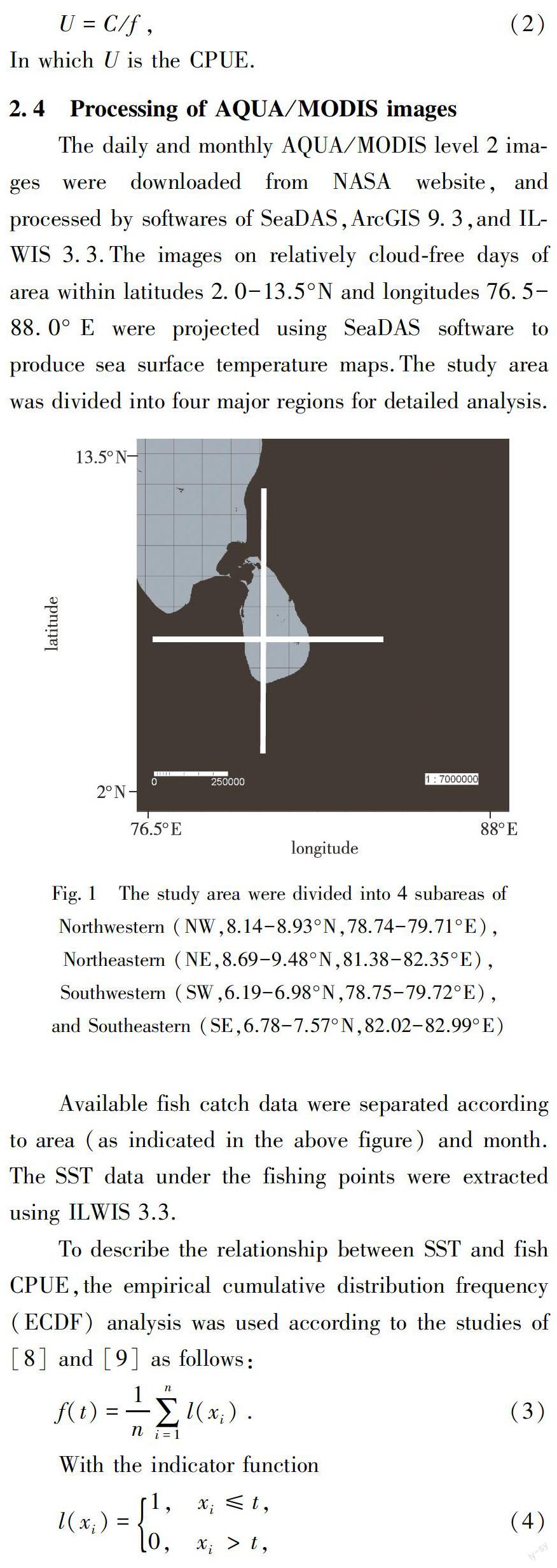
2.1 Study area
The area within latitudes of 2.0-13.5°N and longitudes of 76.5-88.0°E is the target area of this study.This area covers the Sri Lankan exclusive economic zone.
2.2 Satellite data
Satellite remote sensing data of 2006 Aqua/MODIS images were used to analyze the sea surface temperature (SST).MODIS (Moderate-resolution Imaging Spectroradiometer) that was launched in 2002 by the United States provides ideal remote sensing images used for fisheries oceanography[7].
2.3 Fishery data
2.4 Processing of AQUA/MODIS images
The daily and monthly AQUA/MODIS level 2 images were downloaded from NASA website,and processed by softwares of SeaDAS,ArcGIS 9.3,and ILWIS 3.3.The images on relatively cloud-free days of area within latitudes 2.0-13.5°N and longitudes 76.5-88.0°E were projected using SeaDAS software to produce sea surface temperature maps.The study area was divided into four major regions for detailed analysis.
3 Results
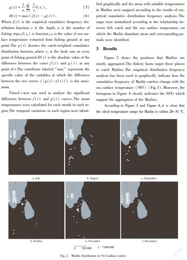
Figure 2 shows the positions that Marlins are mostly aggregated.The fishery boats target these places to catch Marlins.The empirical distribution frequency analysis has been used to graphically indicate how the cumulative frequency of Marlin catches change with the sea surface temperature (SST) (Fig.3).Moreover,the histogram in Figure 4 clearly indicates the SSTs which support the aggregation of the Marlins.
According to Figure 3 and Figure 4,it is clear that the ideal temperature range for Marlin is within 26-31 ℃.In order to find the monsoonal seasons that are ideal for the Marlin catch, seasonal changes of the sea surface temperature has been mapped in Figure 5.
The following Figure 6 shows the maps prepared to identify the locations and the months that are supporting the Marlin distribution in surface waters according to the variations of the SST.They can be used to identify the potential fishing grounds of Marlins as well as to demarcate the bio conservative hotspots.
4 Discussion
Data presented in this study support providing evidence of preferred temperature ranges for Marlins in order to manage the Marlin fisheries better in the future.
4.1 Marlin spatial variations with temperature
The distribution of Marline organisms can be attributed and analyzed according to the various environment conditions which we identify as “hydro-biological variables”. Development and sustainability of Marline related industries requires better understanding of these factors[10].Blue Marlins are highly distributed in tropics among all billfish[11] and are the most common billfish in the catches of longline fisheries in the tropical Pacific Ocean[12].The distributions of blue Marlin density vary seasonally and annually.According to the results of statistical study done with the remote sensing and fish catch data in this study,it is clearly proven that there is a strong relationship between sea surface temperature and Marlin fish distribution.The probable SST when Marlins could be seen is within 26-31 ℃.
According to the above results,the highest CPUE (15.00±0.00) in Northeastern area is available in waters with 27.26±4.44 ℃ SST.The highest mean CPUE in Southeastern area could be seen in months such as July and November with 28.91±0.83 ℃ and 27.46±1.27 ℃ SST,respectively.In Southwestern area the highest CPUE is found in October with a mean SST of 28.02±4.42 ℃.Marlins have been frequently caught from waters with 27.00-28.00 ℃.Hence,with the temperature change occurred with the ENSO events,Marlins shifting can be seen to the preferable temperatures[13].
4.2 SST seasonal variations
According to the mean SST values calculated for each area separately,the suitable temperatures for Marlins fishing are distributed as follows:March to May,July to October and December in Northeastern area,February to June and August to September in Northwestern area,February to July and September to December in Southeastern area,and March to January in Southwestern area.
According to the seasonal variations of the SST,the suitable habitats for the Marlins are mostly in Southwestern region in Northeast monsoon,Northwestern region in the first inter-monsoon,Northeastern region in Southwest monsoon,and again in Southern area in the second inter-monsoon.
The study of Goodyear et al.[6] clearly shows that the habitat utilization of blue Marlins depends on temperature-depth rather than the feeding behavior.They have observed blue Marlin as daylight and sight feeders that regularly descend into the water column to feed or possibly view forage above[6].Furthermore,according to this study the thermocline is a particular factor influencing Marlins.Therefore further studies are needed to investigate the relationship of the Marlin behavioral patterns with the thermocline distribution in ocean around Sri Lanka.
Moreover,SST directly affects the upwelling which brings nutrients to surface waters[14-15] and leads to high primary production attracting food items of Marlins to the surface waters.Hence,SST directly as well as indirectly affects the gathering of Marlins.
4.3 Implications for management
The spatial distribution of the species has to be considered when making effective strategies for managing marine ecosystems.Time-area closures may be the best approach to manage the fisheries and protect species such as bill fish that have pelagic larvae and highly migratory adults[16],because limiting the fishing effort in large areas is not practical[17].Demarcating reserves for Marlin like species should be based on habitat type,ocean conditions,migratory patterns,and prey distributions in order to protect their spawning and nursery grounds.
Global phenomena such as El Nino make the changes in ocean environmental conditions which may affect large-scale shifts in distribution of migratory species.Therefore,identification of the distribution of migratory fish should be combined with the interannual variability.The relationships between SST and Marlin abundance derived in this study can be used to predict the spatial distribution of this fish and hence provide a basis to plan the closed areas.
Moreover,there may be several other factors affect the distribution of Marlins.If the relationship of Marlins with those other oceanographic conditions be identified,the prediction of the potential Marlin fishing grounds will be much easier and cost effective.The results of these studies can be used not only to identify the potential fishing grounds but also for the conservation activities.Most suitable habitats for the Marlins can be identified to demarcate the no-fishing zones and special areas for conservation (SACs) to escalate the abundance of Marlins.
5 Conclusion
The potential fishing grounds for Marlin may well correspond to the dynamics of temperature which could be identified synoptically by sea surface temperature.Satellite images provide a distinctive support in extracting the sea surface temperatures in large areas which cannot be practically analyzed by sample analysis.This study suggests that the preferred range of the sea surface temperature provides a good indicator of initially detecting the potential fishing grounds for Marlin in Sri Lankan ocean.According to the ECDF analysis,there was a significant relationship between the changes of CPUE and SST values of 22-31 ℃.The maximum abundance could be seen within 26-31 ℃.The behavior of Marlin species may change with their maturity stages too.A detailed analysis has to be carried out to identify the changes of Marlin behavior with their maturity stages and considering other oceanographic conditions.
References
[1] Wright C P B.Five of the best blue marlin spots[EB/OL].[2013-09-12].www.marlinmag.com/travel/international/five of the best blue marlin
[2] Prince E D,Ortiz M,Venizelos A,et al.In-water tagging techniques developed by the cooperative tagging center for large,highly migratory species[J].American Fisheries Society Symposium,2002,30:155-171
[3] Rajapaksha J K,Nishida T,Samarakoon L.Environmental preferences of yellowfin tuna (Thunnus albacores) in the northeast Indian Ocean:an application of remote sensing data to long line catches[J].2010
[4] Laurs R M,Fielder P C,Montgomery D R.Albacore tuna catch distributions relative to environmental features observed from satellites[J].Deep-Sea Res,1984,31(9):1085-1099
[5] Hubbs C L,Schultz L P.The northward occurrence of southern forms of marine life along the Pacific coast in 1926[J].Calif Fish Game,1929,15(3):234-241
[6] Goodyear C P,Luo J,Prince E D,et al.Temperature-depth habitat utilization of blue marlin monitored with PSAT tags in the context of simulation modeling of pelagic longline CPUE[J].Science of Social Psychology,2006,59(1):224-237
[7] Yapa K K A S.Upwelling phenomena in the southern coastal waters of Sri Lanka during southwest monsoon period as seen from MODIS[J].Sri Lankan Journal of Physics,2011,10:15-23
[8] Andrade H A,Garcia C A E.Skipjack tuna fishery in relation to sea surface temperature off the southern Brazilian coast[J].Fisheries Oceanography,1999,8(4):245-254
[9] Zainuddin M,Saitoh K,Saitoh S.Albacore tuna in relation to oceanographic condition in the northwestern North Pacific using remotely sensed satellite data[J].Journal of Fisheries Oceanography,2008,17(2):61-73
[10] Uda M.A consideration on the long years trend of the fisheries fluctuation in relation to sea conditions[J].Nippon Suisan Gakkaishi,1957,23:368-372
[11] Molony B. Summary of the biology,ecology and stock status of billfishes in the WCPFC,with a review of major variables influencing longline fishery performance[C]∥The 1st Meeting of the Scientific Committee of the Western and Central Pacific Fisheries Commission,2005:8-19
[12] Hinton M G.Status of blue marlin in the Pacific Ocean,status of Tuna and Billsh stocks in 1999[R].Inter-American Tropical Tuna Commission,La Jolla,CA,USA,Stock Assessment Report 1,2001:284-319
[13] Ward P,Myers R A.Inferring the depth distribution of catchability for pelagic fishes and correcting for variations in the depth of longline fishing gear[J].Journal Canadien Des Sciences Halieutiques Et Aquatiques,2005,62(62):1130-1142
[14] Yu J,Tang D L,Chen G B,et al.The positive effects of typhoons on the fish CPUE in the South China Sea[J].Continental Shelf Research,2014,84(4):1-12
[15] Yu J,Tang D L,Li Y Z,et al.Increase in fish abundance during two typhoons in the South China Sea[J].Advances in Space Research,2013,51(9):1734-1749
[16] Goodyear C P.An analysis of the possible utility of time-area closures to minimize billfish bycatch by U.S. pelagic longlines[J].Fishery Bulletin-National Oceanic and Atmospheric Administration,1999,97(2):243-255
[17] Jensen O P,Ortega-Garcia S,Martell S J D,et al.Local management of a “highly migratory species”:the effects of long-line closures and recreational catch-and-release for Baja California striped marlin fisheries[J].Progress in Oceanography,2010,86(1/2):176-186
