广东省台风降雨型地质灾害特征分析
2017-07-05张伟
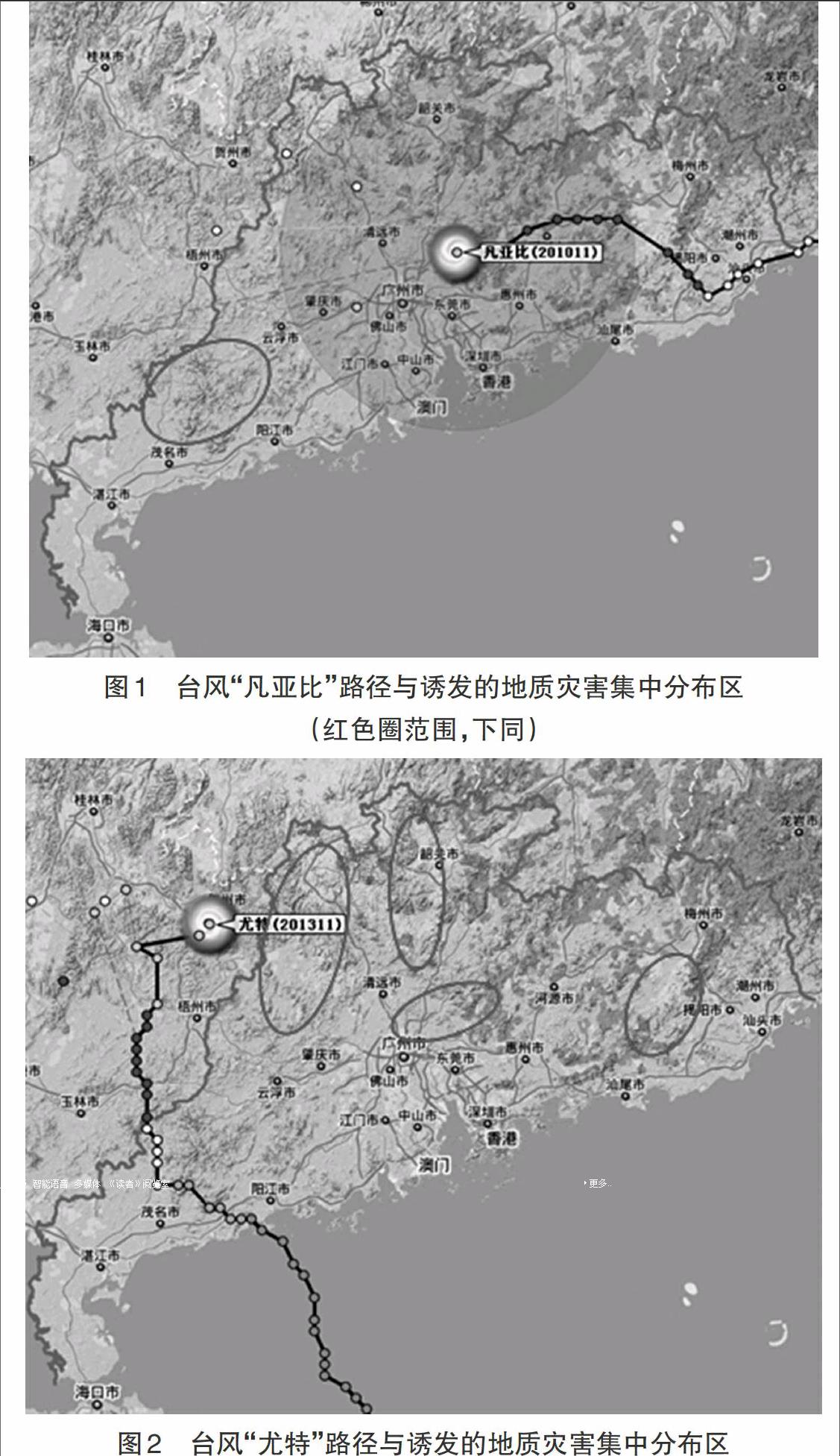

摘 要: 广东地处南海之滨,每年遭受台风侵袭。台风带来的降雨时常诱发地质灾害,造成严重的人员伤亡和经济损失。本文以“凡亚比”和“尤特”两次台风为例,利用历年广东省崩滑流地质灾害灾情统计数据和GIS技术,分析研究了广东省台风降雨型地质灾害空间和时间分布特征。研究表明:广东省台风降雨型地质灾害主要发生在距离台风中心约200km~500km、降雨量为200mm以上的山区,具有一定的滞后效应。
关键词: 台风; 降雨; 地质灾害; 空间分布特征; 时间分布特征
The Analysis on characteristics of Geological Hazards induced by Typhoon Rainfall in Guangdong Province
Zhang Wei
(Institute of Geo-Environment Monitoring of Guangdong Province, Guangzhou 510510, China)
Abstract:Guangdong located on the South China Sea where attacked by typhoon every year. Typhoon rainfall often induces geological hazards which causing serious casualties and economic losses. In the paper, taking the two typhoon "FANAPI" and "UTE" as examples, using of geological hazards statistical data and GIS technology, analysis on the characteristics of geological hazards induced by typhoon rainfall in Guangdong Province. The analysis showed that geological hazards induced by typhoon rainfall mainly occur in the mountain area where is about 200~500km from the typhoon center and the rainfall is over 200mm, which has a certain lag effect.
Keywords:typhoon; rainfall; geo hazards; spatial distribution characteristics; time distribution characteristics
1. 前言
廣东地处南海之滨,每年登陆的台风4个~5个,间接影响的台风5个~6个。台风带来的降雨持续时间不长,一般为2d~4d,但降雨强度较大,最大日降雨量一般达100mm以上,降雨常常引发新的地质灾害隐患,并导致重大地质灾害灾情发生。近20年来,诸多专家学者对降雨诱发地质灾害规律、机理和气象风险预警做了大量研究[1-12]。然而,尚未对广东省台风降雨型地质灾害进行深入的专题研究。因此,本文以影响广东的两次台风过程“凡亚比”和“尤特”为例,利用历年广东省崩滑流地质灾害灾情统计数据和GIS技术,分析研究了广东省台风降雨型地质灾害空间和时间分布特征。
2. 台风“凡亚比”和“尤特”概况
2010年11号台风“凡亚比”于9月20日07时在福建漳浦县登陆。受其影响,从21日0时开始,广东多地出现暴雨到大暴雨,特别是粤西的高州市、信宜市、阳春市遭遇超200年一遇特大暴雨。降雨引发地质灾害204起,造成3人受伤,31人死亡和失踪,直接经济损失7200万元。……