华北平原典型干旱年土壤水分及灌溉特征遥感分析
2016-11-12安淳淳王飞焦俏张雨果
安淳淳,王飞,3†,焦俏,张雨果
(1.中国科学院水利部水土保持研究所,712100,陕西杨凌;2.中国科学院大学,100049,北京;3.西北农林科技大学水土保持研究所,712100,陕西杨凌;4.西北农林科技大学资源与环境学院,712100,陕西杨凌)
华北平原典型干旱年土壤水分及灌溉特征遥感分析
安淳淳1,2,王飞1,2,3†,焦俏4,张雨果4
(1.中国科学院水利部水土保持研究所,712100,陕西杨凌;2.中国科学院大学,100049,北京;3.西北农林科技大学水土保持研究所,712100,陕西杨凌;4.西北农林科技大学资源与环境学院,712100,陕西杨凌)
华北平原作为我国的粮食主产区,土壤水分是制约作物生长的主要限制因子。本文首次运用土壤水分指数数据,对华北平原土壤水分以及灌溉特征进行空间分析,旨在为区域尺度农田旱情以及农作物产量的实时监测与预报提供相关参考。研究基于1993—2002年华北平原逐旬降雨数据和主动微波遥感反演的土壤水分指数数据,应用地统计分析方法,分析典型干旱年(1999年)该区表层土壤水分时空变异特征,并提取和分析小麦生长期内的灌溉信息;通过对逐旬的降水和土壤水分数据的空间叠置分析,提取区域内的灌溉信息。结果表明:1999年降水量比多年(1993—2002年)平均量少约140mm;1999年土壤水分变化与降水变化整体保持一致,低于多年平均水平,春季和夏季,土壤水分减少尤为明显,土壤干旱非常普遍;小麦生长期内,大部分地区均存在不同程度的灌溉,其中中部地区灌溉次数最少,占研究区面积的65%左右的南部和北部地区灌溉次数多为2~3旬次。采用降水量和遥感水分监测数据,可以分析土壤水分变化的原因,提取灌溉的范围和时间特征,并可为旱情遥感监测提供科学参考。
土壤水分;时空变异特征;降水;灌溉;华北平原
土壤水是作物吸水的最主要来源[1],对于我国的旱作农业和植被生长具有十分重要的意义[2-3]。华北平原作为我国的重要粮食产区,除降水补给,土壤水分还在很大程度上受灌溉影响,灌溉也因此成为制约作物生长的主要限制因素[4]。有关灌溉问题的研究较多,主要集中在对农田作物水分亏缺程度的评价等方面[5-9],关于灌溉范围及持续时间的研究较少。如何运用遥感数据对大范围地表土壤水分及干旱、灌溉问题进行监测,有着特别重要的价值。本文所使用的主动微波遥感数据来源于欧洲航空局(European Space Agency,ESA)发射的欧洲遥感卫星(European Remote Sensing Satellites,ERS),ERS -1/2(1990—2005年)以及METOP- A(2006—2016年),其上搭载的风散射计(wind scatterometer,WSC)以及新一代散射计(advanced scatterometer,ASCAT),由于散射信号对土壤水分响应敏感,较短重复周期观测的优势,近年来被用于陆地地表土壤水分监测的研究[10-15]。维也纳工业大学利用上述数据反演并制作出全球表层土壤水分数据集(the Essential Climate Variable Soil Moisture dataset,ECV SM)[16],在世界各地被广泛应用和评价[17-18]。M. Zribi等[11]、W.Wagner[16]等、蒋冲等[19]以及焦俏等[20]对ERS散射计数据反演获取的土壤水分指数进行相关验证及分析,结果表明该数据可较好的反映表层土壤水分的变化。本文采用微波遥感与地统计学理论相结合的方法,在气象干旱的条件下,估算华北平原表层土壤水分时空变异,对该地灌溉信息进行试提取分析,并进行相关验证,力图利用已有数据,为区域旱情遥感实时监测与准确预报提供一定的科学依据,以期合理利用水资源,有效地改善生态环境和农业生产基础条件,减少水、旱等自然灾害。
1 研究区概况
华北平原又称黄淮海平原,坐落于中国东部偏北、黄河下游,位于E 112°48′~122°45′,N 32°~40° 24′,北起燕山,西沿太行山、伏牛山,南抵淮河干流及苏北灌溉总渠,东临渤海与黄海,面积约33万km2[21]。华北平原降水时空分布不均[22],6—9月集中了全年降水量的80%左右,易春旱秋涝[5]。华北平原地区耕地面积占全国总耕地面积的25%,是我国几大农业区中耕地面积最多的地区[7],农业灌溉用水在水资源利用中占有很大的比例[5]。
2 资料与方法
2.1 数据资料
2.1.1 土壤水分数据 笔者使用的土壤水分数据来源于ECV数据集中的主动微波数据,主要由奥地利维也纳工业大学W.Wagner等[16]利用变化检测的方法,归一化散射计后向散射系数,将土壤水分中植被根系和叶片等所包含的植物水部分去掉,消除土壤表面粗糙度和植被覆盖对土壤水分的影响后,通过TU Wien模型,反演计算得到去除植被影响后的纯裸露地表0~5 cm表层土壤水分(surface soil moisture,SSM),再结合描述水分再分配过程的二层水模型,由SSM推导出0~100 cm土壤水分指数(soilwater index,SWI)[1516,2325]。土壤水分指数计算公式如下:
式中:ms指ti时刻的表层(0~100 cm)土壤水分,%;最小时间间隔为[t,t~T],3次实验最小时间间隔为[t,t~5T];参数T是以天为单位的土壤和气候特征常数,通过计算SWI和地面观测值之间的相关关系得到。实验结果表明,当T值取20 d,0~100 cm层的实测数据和遥感数据相关关系最好。
笔者使用的数据持续范围为1993—2002年,时间分辨率为1 d,空间分辨率为25 km[26]。对于冰雪覆盖和冻土地区,由于卫星雷达无法测得土壤表面的反射率,无法进行反演,因此在每年12月至次年1—2月,数据都存在不同程度的缺失情况[16]。蒋冲等[19]、焦俏等[20]以及Jiao Qiao等[27]对该土壤水分数据的适用性和精度进行相关验证,结果表明该数据可较为准确地反映表层(0~100 cm)土壤水分的时空变化,该数据在华北平原验证结果与焦俏等[20]研究结果一致,即SWI与实测土壤水分在土壤表层呈极显著相关,显著性随着土层深入不断降低,相关系数r随土层深入由0.8下降至0.4,故本文不再对该数据的验证部分做赘述。
2.1.2 气象数据 数据来源于中国气象科学数据共享服务网提供的1993—2002年华北平原及其周边地区53个国家农业气象观测站的降水旬值资料,其中降水量数据单位为mm。
2.1.3 土地利用数据 使用的2000年1:10万土地利用数据,来自“地球系统科学数据共享网”。土地利用数据内容包括耕地、林地、草地、水域、城乡工矿居民用地、未利用土地等6个一级类型和25个二级类型。
2.2 研究方法
2.2.1 表层土壤水分时空动态特征分析 利用算术平均法,由原始土壤水分日值数据,计算出华北平原土壤水分旬值。
在Matlab软件中,将1993—2002年各旬的土壤水分点值数据转换为空间栅格数据,得到该地区各旬的土壤水分空间分布图,栅格像元大小为25 km× 25 km。在ArcGIS中,利用栅格计算器计算出该区域各月的土壤水分空间分布图以及多年平均月值图,从而分析该研究区降水减少的年份,土壤水分的空间变化状况,并进行统计分析。
2.2.2 降水特征与尺度一致化处理 使用普通克里金插值方法,对华北平原地区1993—2002年降水旬值分别进行插值,将气象站点的降水量点值数据转换为空间栅格数据,并进行尺度归一化处理,得到该地区各旬的降水空间分布图,其分辨率和SWI数据保持一致,栅格像元大小为25 km×25 km。利用栅格计算器生成该地区各月的降水空间分布图以及多年平均月值图,选择降水明显减少的1999年为典型代表年份,进行相关统计分析。
2.2.3 灌溉信息提取 以小麦为主的夏粮作物和以玉米为主的秋粮作物为该区域的主要农业用水作物,且小麦的灌溉用水量远远超过玉米的灌溉用水量[4];因此,对1999年小麦用水高峰期3—5月(7—15旬)共9旬的降水和土壤水分空间数据依次进行前后旬差异分析,前后旬的差异变化结果按照减少和增加进行重分类。将降水和土壤水分重分类的结果进行叠加分析,在降水比前一旬减少的情况下,每次的土壤水分增加,可能是区域内部分地块存在灌溉,统计为该地区可能灌溉旬次数,对华北平原灌溉持续时间以及灌溉范围进行分析。
在ArcGIS中,对华北平原2000年土地利用类型数据重采样,重采样后栅格像元大小和SWI数据一致(为25 km×25 km);利用分类工具,筛选出耕作管理区,将农田类型栅格与其他类型栅格分离,用以对上述灌溉提取信息进行验证分析。
3 结果与分析
3.1 降水反映气象干旱特征
图1为华北平原1999年以及1993—2002年多年平均降水的年内月尺度分布特征以及月尺度累积分布特征。如图1所示,1999年各月降水量与1993—2002年多年平均月降水量在数量上以及月份分布上有一定差异,其中:6—8月降水量与同期多年平均降水量差异较大,平均低约50 mm左右;9、10月份降水较同期多年平均有所增加。整体而言,1999年降水年内分布较多年平均分布稍均匀,1999年月累积降水量均小于多年平均月累积降水量,且该年内夏季降水大幅度减少,故而降水总量低于1993—2002年多年平均降水总量约140 mm,导致该地区在1999年表现为较干旱的气象特征;因此选取1999年为典型干旱年,对土壤水分及灌溉特征进行相关分析。
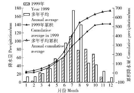
图1 华北平原降水量的年内变化特征Fig.1 Annual variation of precipitation in the North China Plain
3.2 SW I反映农业干旱时空特征
华北平原SWI相关计算结果表明,土壤水分时间序列变化趋势与上述降水变化趋势整体保持一致,具有规律性的波动。1999年3—9月土壤水分值均低于同期多年(1993—2002年)平均值,而10、11月由于夏季降水补充,土壤水分含量高于同期多年平均土壤水分含量。1999年土壤水分累积平均月值均低于多年平均月值,说明研究区1999年土壤水分值较多年平均值偏低,因土壤水分缺失而导致的农业干旱较普遍。
华北平原1999年3—11月份土壤水分盈亏状态的空间分布图进一步显示:同一时间内不同地区的土壤水分与该地区多年平均土壤水分的差异各不相同,华北平原北部地区3月份土壤水分比同期多年平均土壤水分低约5%~10%,而南部地区土壤水分较多年平均土壤水分高约10%,个别地区高约15%(图3(a));同一地区不同时间的土壤水分变化差异显著。例如:河南省周口市春季3—5月份土壤水分均比该地多年平均土壤水分高约5%~10%,夏季8月由于降水较该地多年平均降水减少,土壤水分随之减少;山东半岛地区的烟台等地,除10、11月份受夏末秋初降水补充影响,土壤水分高于多年平均土壤水分外,其他月份均表现为低于多年平均土壤水分,表现为持续干旱,以8、9月份最为显著,比多年平均土壤水分低约10%~20%。
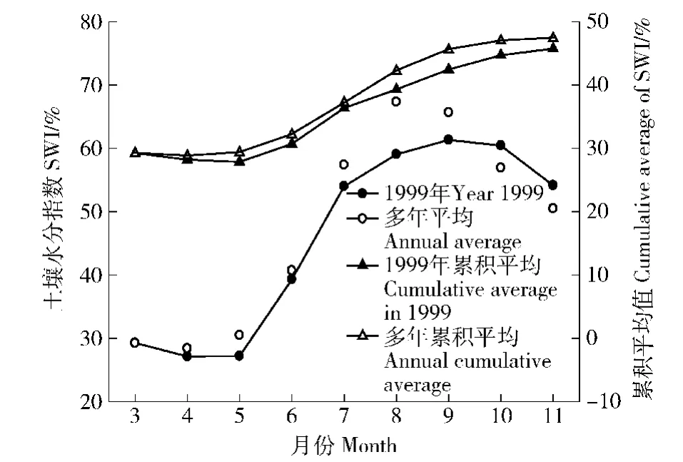
图2 华北平原SWI时间变化Fig.2 Changes of SWI(soilmoisture index)in the North China Plain
3.3 灌溉区域和时间分布
华北平原灌溉信息提取结果如图4所示,该研究区域内各地区3—5月灌溉的可能性次数,即在降水基本保持不变或者减少的情况下土壤水分增加的次数。从图4可以看出,该研究区内大部分地区均存在不同程度的灌溉,这与该地区2000年土地利用重采样后所分离出来的耕作管理区结果(图5)整体相符,即图4中所所示灌溉的栅格单元,与图5中所显示的属于耕作管理区的栅格单元大体相匹配,结果匹配程度为79.69%,表明研究中所用的提取灌溉信息的方法在一定程度上可以作为农业旱情监测的参考依据。该研究区域内可能存在灌溉的地区大体呈南北对称分布,山东省中部灌溉次数最少,这与图3中该地区春季土壤水分较多年平均土壤水分减少的结果相符合,即在降水保持基本稳定的情况下,由于灌溉不足,土壤水分减少。以山东省中部为界,南北两侧灌溉次数多为2~3次,其中灌溉为2次的地区所占比例约为30.55%,灌溉为3次的地区所占比例约为34.17%,个别地区,如河南省周口市北部以及天津市东北部,灌溉次数达到4~5次,即可能该地区存在持续灌溉,这也与上图中天津、周口等地3—5月份土壤水分较多年平均土壤水分增加的结果相一致。

图3 华北平原SWI空间变化特征(图中各颜色表示1999年SWI距平值与1993—2002年年均SWI的差值所属范围)Fig.3 Spatial distribution of SWI in the North China Plain(Colors in the figure indicate the range of SWI in 1999 related to average one from 1993 to 2002)
4 结论与讨论
1)华北平原1999年降水总量较1993—2002年多年平均降水量低约140mm,表现为气象较干旱的特征,在一定程度上导致该地的农业干旱。
2)华北平原1999年土壤水分值低于多年平均值,从而在该年呈现出农业干旱。同一时间内不同地区的土壤水分与多年平均土壤水分的差异不同;同一地区不同时间的土壤水分变化差异显著;山东半岛地区的烟台等地,表现为持续干旱。
3)研究区内大部分地区均存在不同程度的灌溉,利用空间叠置分析法,结合降水以及土壤水分数据,对灌溉范围及持续时间进行相关分析,可在一定程度上作为灌溉信息提取的参考。
4)本文所使用的土壤水分数据是由主动微波遥感反演而来,由于其空间分辨率较低,故可能在一定程度上对灌溉信息提取的精确度产生影响,相信随着其散射计更新换代以及反演方法的进一步完善,加之其对土壤水分响应敏感且具有较高时间分辨率的优势,再结合较高时间分辨率的降水数据,在一定程度上可以为区域旱情遥感监测与预报提供一定的依据。由于灌溉受降水、植被以及人类活动等多重驱动因子的影响,其时空变化特征较为复杂,文中仅利用降水和土壤水进行试提取分析,其他因素对灌溉信息提取的影响有待进一步研究。

图4 华北平原灌溉信息Fig.4 Irrigation information of the North China Plain

图5 华北平原土地利用Fig.5 Land use of the North China Plain
[1] 张友静,王军战,鲍艳松.多源遥感数据反演土壤水分方法[J].水科学进展,2010,21(2):222. Zhang Youjing,Wang Junzhan,Bao Yansong.Soilmoisture retrieval from multi-resource remotely sensed images over wheatareas[J].Advances in Water Science,2010,21(2):222.(in Chinese)
[2] 穆兴民,陈霁伟.黄土高原水土保持措施对土壤水分的影响[J].土壤侵蚀与水土保持学报,1999,5(4):39. Mu Xingmin,Chen Jiwei.Effects of measures of soil and water conservation on soil water content in Loess Plateau[J].Journal of Soil Erosion and Soil and Water Conservation,1999,5(4):39.(in Chinese)
[3] 王信增,焦峰,刘源鑫,等.不同空间尺度土壤水分与环境因素的关系[J].生态学杂志,2012,31(2):319. Wang Xinzeng,Jiao Feng,Liu Yuanxin,et al.Relationships between soil moisture and environmental factors at different spatial scales[J].Chinese Journal of Ecology,2012,31(2):319.(in Chinese)
[4] 姜杰,张永强.华北平原灌溉农田的土壤水量平衡和水分利用效率[J].水土保持学报,2004,18(3):61. Jiang Jie,Zhang Yongqiang.Soil-water balance and water use efficiency on irrigated farmland in the North China Plain[J].Journal of Soil and Water Conservation,2004,18(3):61.(in Chinese)
[5] 张光辉,费宇红,刘春华,等.华北平原灌溉用水强度与地下水承载力适应性状况[J].农业工程学报,2013,29(1):1. Zhang Guanghui,Fei Yuhong,Liu Chunhua,et al.Adaptation between irrigation intensity and groundwater carrying capacity in North China Plain[J].Transactions of the Chinese Society of Agricultural Engineering,2013,29(1):1.(in Chinese)
[6] 孙美.华北平原作物产量与土壤氮素淋失对灌溉施肥的响应模拟[D].北京:中国农业大学,2014:54. Sun Mei.Simulation of crop yield and nitrogen leaching response of irrigation and fertilization in the North China Plain[D].Beijing:China Agriculture University,2014:54.(in Chinese)
[7] 吴泽新.气候变化对黄淮海平原主要粮食作物的影响[D].兰州:兰州大学,2007:9. Wu Zexin.The effect of the climate change on the main grain crop in Huang-Huai-Hai Plain[D].Lanzhou:Lanzhou University,2007:9.(in Chinese)
[8] 胡玉昆,杨永辉,杨艳敏,等.华北平原灌溉量对冬小麦产量、蒸发蒸腾量、水分利用效率的影响[J].武汉大学学报(工学版),2009,42(6):701. Hu Yukun,Yang Yonghui,Yang Yanmin,et al.Effect of irrigation on winter wheat yield,evapotranspiration andwater use efficiency in North China Plain[J].Engineering Journal of Wuhan University,2009,42(6):701.(in Chinese)
[9] 房全孝,王建林,于舜章.华北平原小麦-玉米两熟制节水潜力与灌溉对策[J].农业工程学报,2011,27(7):37. Fang Quanxiao,Wang Jianlin,Yu Shunzhang.Water saving potential and irrigation strategies for wheat-maize double cropping system in the North China Plain[J]. Transactions of the CSAE,2011,27(7):37.(in Chinese)
[10]陈权,李震,王磊,等.用ERS风散射计数据估算土壤水分方法的研究[J].遥感学报,2007,11(6):803. Chen Quan,Li Zhen,Wang Lei,et al.The study ofestimating soil moisture using ERS wind scattero meter[J]. Journal of Remote Sensing,2007,11(6):803.(in Chinese)
[11]Zribi M,PardéM,Rosnay PD,etal.ERS scattero meter surface soil moisture analysis of two sites in the South and North of the Sahel Region of West Africa[J].Journal of Hydrology,2009,375(1):253.
[12]Naeimi V.Model Improvements and error characterization for global ERS and Metop scatterometer soil moisture data[D].Vienna,Austria:Vienna University of Technology,2009:1.
[13]Albergel C,Rudiger C,Pellarin T,etal.From near surface to root zone soil moisture using an exponential filter an assessment of the method based on in situ observations and model simulations[J].Hydrology and Earth System Sciences,2008,12(6):1323.
[14]Zhao Deming,Su Bingkai,Zhao Ming.Soilmoisture retrieval from satellite images and its application to heavy rainfall simulation in Eastern China[J].Advances in Atmospheric Sciences,2006,23(2):299.
[15]Klaus S.Global soil moisture retrieval from ERS scattero meter data[D].Vienna,Austria:Vienna University of Technology,2002:1.
[16]WagnerW,Klaus S,Carsten P,et al.Evaluation of the agreement between the first global remotely sensed soil moisture data with model and precipitation data[J].Journal of Geophysical Research,2003,108(D19):1675.
[17]WagnerW,Bloschl G,Pampaloni P,et al.Operational readiness of microwave remote sensing of soil moisture for hydrologic applications[J].Nordic Hydrology,2007,38(1):1.
[18]Pellarin T,Calvet J,Wagner W.Evaluation of ERS scatterometer soil moisture products over a half degree region in Southwestern France[J].Geophysical Research Letters,2006,33(17):123.
[19]蒋冲,王飞,穆兴民,等.土壤湿度指数在黄土高原的适宜性评价[J].灌溉排水学报,2012,31(3):31. Jiang Chong,Wang Fei,Mu Xingmin,et al.Evaluation of the soilwater index and surface soilmoisture on the Loess Plateau[J].Journal of Irrigation Drainage,2012,31(3):31.(in Chinese)
[20]焦俏,王飞,李锐,等.ERS卫星反演数据在黄土高原近地表土壤水分中的应用研究[J].土壤学报,2014,51(6):1388. Jiao Qiao,Wang Fei,LiRui,etal.Application of inversion of European remote sensing satellites data to investigation of near-surface soilmoisture in Loess Plateau[J]. Acta Pedologica Sinica,2014,51(6):1388.(in Chinese)
[21]莫兴国,薛玲,林忠辉.华北平原1981—2001年作物蒸散量的时空分异特征[J].自然资源学报,2005,20(2):181. Mo Xingguo,Xueling,Lin Zhonghui.Spatial-temporal distribution of crop evapotranspiration from 1981- 2001 over the North China Plain[J].Journal of Natural Resource,2005,20(2):181.(in Chinese)
[22]岳现录.华北平原小麦-玉米轮作中有机肥的氮素利用与去向研究[D].北京:中国农业科学院,2009:12. Yue Xianlu.Study on nitrogen fate and efficiency of organicmanure in wheatmaize rotation system in North China Plain[D].Beijing:Chinese Academy of Agricultural Sciences,2009:12.(in Chinese)
[23]WagnerW,Guido L,Maruice B,etal.A study of vegetation cover effects on ERS scatterometer data[J].IEEE Transactions on Geoscience and Remote Sensing,1999,37(2):938.
[24]Fontaine B,Louvet S,Roucou P,et al.Fluctuations in annual cycles and inter-seasonal memory in West Africa:precipitation,soil moisture and heat fluxes[J].Theoretical and Applied Climatology,2007,88(1):57.
[25]WagnerW.Soilmoisture retrieval from ERS scattero meter data[D].Vienna:Vienna University of Technology,1998:61.
[26]Wagner W,Lemoine G,Rott H.Amethod for estimating soilmoisture from ERS scattero meter and soil data[J]. Remote Sensing of Environment,1999,70(2):191.
[27]Jiao Qiao,Li Rui,Wang Fei,etal.Impacts ofre-vegetation on surface soilmoisture over the Chinese Loess Plateau based on remote sensing datasets[J].Remote Sensing,2016,8(2):156.
Soil moisture and irrigation analysis in the typical drought years of the North China Plain using remote sensing data
An Chunchun1,2,Wang Fei1,2,3,Jiao Qiao4,Zhang Yuguo4
(1.Institute of Soil and Water Conservation,Chinese Academy of Sciences and Ministry of Water Resources,712100,Yangling,Shaanxi,China;2.University of Chinese Academy of Sciences,100049,Beijing,China;3.Institute of Soil and Water Conservation,Northwest A&F University,712100,Yangling,Shaanxi,China;4.College of Natural Resources and Environment,Northwest A&FUniversity,712100,Yangling,Shaanxi,China)
[Background]Soil moisture is one of the most important components of soil,it plays a critical role in the process of soil formation.Moreover,soil moisture is the main source of crop water,and is one of the most crucial parameters for the agriculture,meteorology and hydrology studies.As the important agricultural region in China,in addition to the precipitation recharge,soil moisture in the North China Plain(NCP)is also largely affected by irrigation.How to monitor and analyze surface soil moisture,drought and irrigation of a wide range using remote sensing data,has a especially important value.Studies on soil moisture and irrigation information can provide better understanding about thedrought.[Methods]On the basis of 10-day's precipitation data,active microwave remote sensing inversion data-soil moisture index(SWI)data,combined with geo-statistical analysis methods,the spatial and temporal variation of surface soil moisture under precipitation drought in the NCPwas analyzed and irrigation information in the main growing season of winter wheat was extracted by the method of spatial overlay analysis.[Results]1)There were some differences in the amount and distribution of precipitation between 1999 and 1993- 2002.Precipitation in June,July and August of 1999 was 50mm lower than the average of 10 years(1993- 2002),precipitation in September and October of 1999 was a little higher than the average of10 years(1993- 2002);precipitation in 1999 was more evenly distributed than annual average of1993- 2002.Precipitation in the NCP in 1999 was140mm less than the average of 10 years(1993- 2002).2)The change of soilmoisture was consistent with the change of precipitation,which had regular fluctuation.The SWI in 1999 was lower than the average of 10 years(1993- 2002),especially from March to September,which was consistent with variation of precipitation;the SWI decreased remarkably in spring and summer,which caused the soil drought to some extent.The differences of SWI between 1999 and 1993- 2002 were different in different regions;the differences of soil moisture content in different stages was significant in the same area.3)Most areas in the NCP in 1999 were irrigated in different degrees in the main growing season of winter wheat;the irrigation times in the middle part was the least,and there existed two or three rounds of irrigation in the northern and southern parts,which accounted approximately 65%of the total study area.The irrigation cells were 79.69% same with extracted result using land use data in 2000.[Conclusions]The decrease of precipitation in 1999 had an effect on variation of SWI.The soil moisture in 1999 decreased,which was consistent with the change of precipitation,indicating the arid characteristic of soil.There existed different degrees of irrigation in the NCP in 1999.The study results and methods may provide references for the agricultural drought monitoring based on remote sensing.
soil moisture;spatial and temporal variation characteristics;precipitation;irrigation;North China Plain
S152.7
A
1672-3007(2016)05-0123-07
10.16843/j.sswc.2016.05.016
2016- 04- 05
2016- 06- 21
项目名称:国家自然科学基金“基于相同气候条件的人类活动对河流水沙影响定量评价:以黄土高原延河流域为例”(41171420);中国科学院国际合作局对外合作重点项目“基于中欧农业生产与环境恢复的交互式土壤质量评价”(16146KYSB20150001)
安淳淳(1992—),女,硕士研究生。主要研究方向:土壤水分遥感监测。E-mail:anchunchun213@163.com
†通信作者简介:王飞(1971—),男,博士,副研究员。主要研究方向:水土保持环境监测与影响评价。E-mail:wafe@ms.iswc. ac.cn