金沙江上游雪隆囊古滑坡堰塞湖溃坝堆积物粒度特征
2016-06-18陈松陈剑刘超马俊学
陈松, 陈剑, 刘超, 马俊学
(中国地质大学工程技术学院,100083,北京)
金沙江上游雪隆囊古滑坡堰塞湖溃坝堆积物粒度特征
陈松, 陈剑†, 刘超, 马俊学
(中国地质大学工程技术学院,100083,北京)
摘要:金沙江上游地质灾害频发,地质环境演化相对复杂。为研究堰塞湖溃坝后堆积物的来源与坝体物质、沉积环境的关系,以金沙江上游雪隆囊古滑坡堰塞湖溃坝堆积物为主要研究对象,通过野外实地调查取样和室内粒度筛分试验,对雪隆囊滑坡堰塞湖溃坝堆积物的粒度进行测试,并分别对滑坡堰塞湖溃坝堆积物的上、中、下游3段的粒度特征进行研究。结果表明:从溃坝堆积体的上游到下游,粒度分布曲线分别为单峰、多峰、双峰;上游粒度组成主要以砾石为主,中游和下游主要以细砂和极细砂为主,粒度从上游到下游依次有明显的细化趋势,平均粒度由粗变细,分选性整体上较差和差。以上这些特点综合反映出溃坝堆积体的上游段到下游段的水动力条件在逐渐减弱,其中堆积体上游段砾石部分来自坝体物质,而中、下游段细粒部分既可能来自坝体,又可能来自堰塞湖溃坝前的上游湖相沉积层。
关键词:雪隆囊; 古滑坡; 堆积物; 粒度特征; 金沙江
沉积物粒度分布特征分析已经广泛应用于沉积环境领域,对地质环境演化的研究影响很大[1-3]。现今,粒度特征分析已在深海、黄土、古土壤、湖泊、冰川、泥石流等沉积物研究中广泛应用[4-9],也有将粒度分析与分形理论同工程性质相结合的研究[10-12],然而,关于堰塞湖溃坝的研究,国外最早主要是针对冰川及冰碛堰塞湖溃坝堆积体的研究[13-16];国内由地震诱发的滑坡堰塞湖也屡见不鲜[17-18],崔之久等[19]对各种类型的堰塞湖及溃坝后的堆积体做了初步论述。有的学者只对产生堰塞湖上游的湖相沉积物进行粒度研究[20-21];有的学者[22-26]主要是对滑坡产生的堰塞坝溃坝过程进行数值模拟或稳定性计算。而这些学者基本上研究的是冰川、冰碛溃坝后的堆积物特点或堰塞湖上游湖相沉积物的特征,有的把重点放在研究堆积体现状评价、堆积体本身力学性质的研究,缺乏对堆积体成因过程的系统把握。目前,关于滑坡堰塞湖溃坝堆积方面的研究甚少,基本未涉及溃坝堆积体的粒度特征与沉积环境、堰塞坝物质组成关系方面的研究。关于金沙江上游古滑坡堰塞湖溃坝堆积沉积物的粒度分析这方面的研究工作缺乏,目前只有陈剑等[27]对该区堰塞湖溃坝堆积体的发现做了初步论述;因此,为对金沙江上游水土地质灾害的环境进行治理与预测,笔者在野外考察的基础上,对雪隆囊古滑坡堰塞坝溃决后沿程堆积物粒度进行采样分析,揭示该堆积物的粒度特征及变化规律,对研究堰塞湖溃坝后堆积物的来源与坝体物质组成及沉积环境的关系具有重要意义,可为今后金沙江上游流域水土保持的治理提供参考。
1研究区概况
位于西藏芒康县金沙江上游,E 98°05′~98°55′N 29°20′~29°36′。金沙江上游雪隆囊至王大龙河段,区内河水位与最高点相对高差约为3 800 m,沟谷河流海拔2 300 m左右,峡谷宽100~200 m,沿江沟谷地形坡度25°~60°,有的地段坡度>70°。金沙江断裂带的主断裂雄松—苏哇龙活动断裂在其东部附近穿过(图1)。沿江河谷裸露岩石的岩性主要为二叠系片岩、火山岩和大理岩等。该区岩层节理较发育受金沙江活动断裂带的影响,崩塌现象频发[27]。
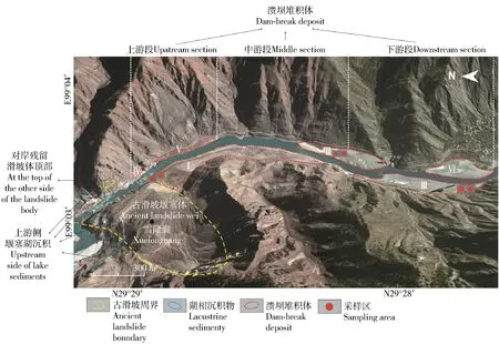
图2 雪隆囊古滑坡堰塞湖溃坝堆积体的分布范围Fig.2 Distribution of the dam-break deposits of dammed lake caused by Xuelongnang ancient landslide
经过野外调查发现,滑坡坝堰塞湖溃坝后将堰塞坝及堰塞湖内沉积物冲向下游,最终导致被冲下的物质堆积在金沙江河道两侧(图2),根据堆积物的位置不同,将这段河段分为溃坝堆积体的上、中、下3段,并将堆积体进行编号(图2中I~VI号)以便分析。经陈剑等[27]对金沙江上游雪隆囊古滑坡堰塞湖溃坝堆积体的研究初步判断,滑坡堰塞体是由砾石,砂和少量黏土组成的混杂堆积物。
2研究方法
2.1样品采集与粒度的测量
在野外调查基础上,对雪隆囊地区溃坝堆积体的上游段、中游段、下游段等分布区域进行采样,每个采样点的取样量为25 cm×25 cm×20 cm。共计采集样品21个并编号,将样品在实验室用一套标准的振筛机(4~0.065 mm)进行筛分实验。采样点位置如图2所示。采样的编号、颗粒级配以及堆积物的室内颗粒分析成果见表1、表2和表3。由于数据量较大只给出部分原始数据。
2.2粒度特征及形状分析
采用克鲁宾(Krumbein)粒级标准划分粒度公式[28]
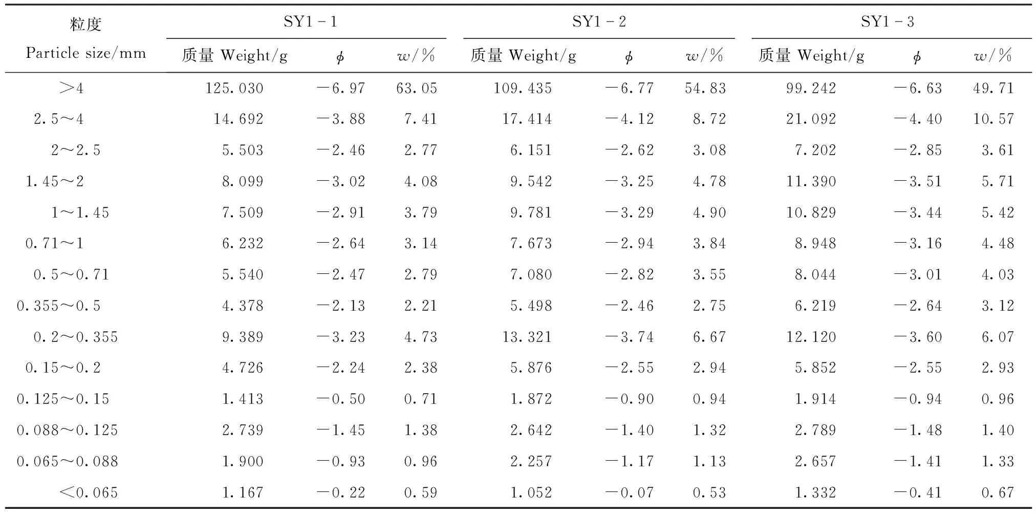
表1 堆积物上游段颗粒
注:φ为粒度的对数值;w为各粒度所占比例;SY1-1~SY1-7为上游各采样点的编号。下同。Note:φ: the logarithm of granularity;w: the percentage of each particle size; SY1-1~SY1-7: the No. of sample points in the upstream section. The same as below.
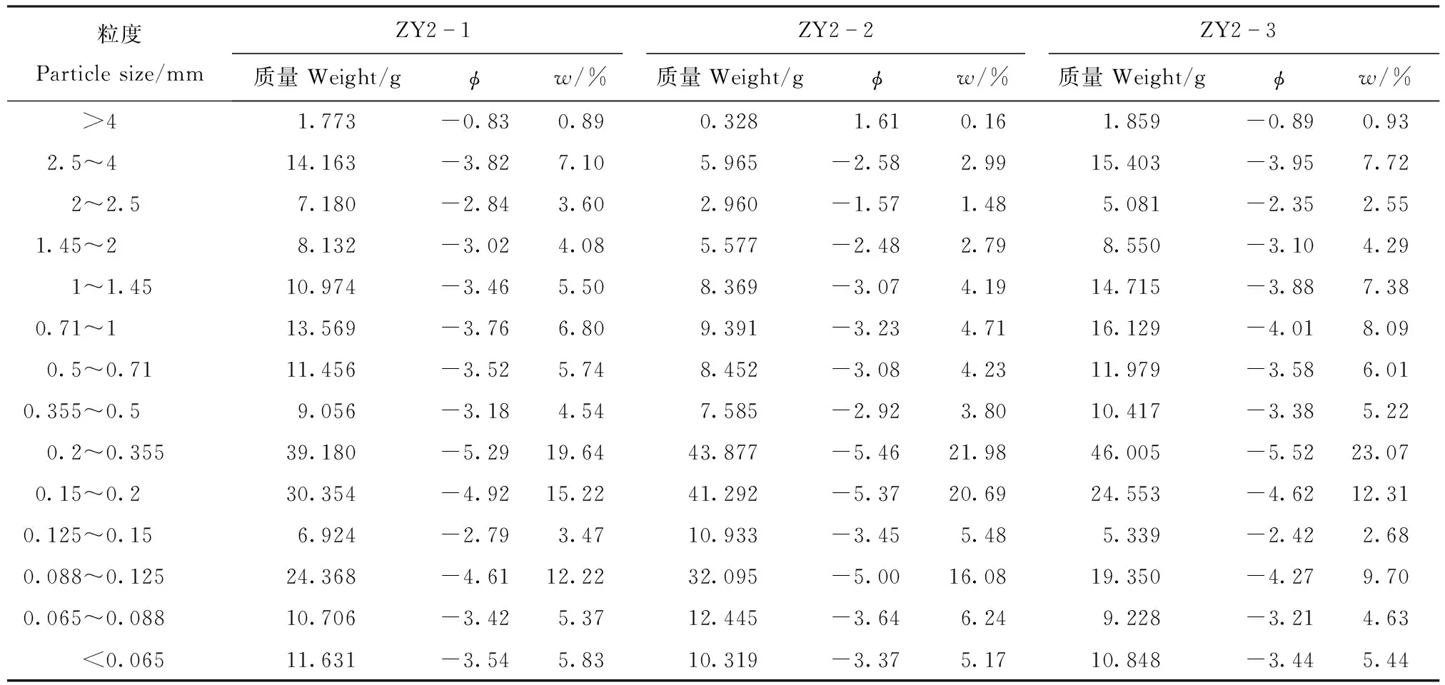
表2 堆积物中游段颗粒
注:ZY2-1~ZY2-7表示中游各采样点的编号。Note: ZY2-1~ZY2-7: the No. of sample points in the middle section.
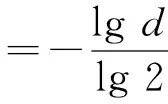
(1)
式中:φ为粒度的对数值;d为颗粒的直径,mm。
3结果与讨论
3.1堰塞湖溃坝堆积物的粒度组成
整个研究区域的粒度主要由砾石、砂粒、粉粒和极少量的黏粒组成。从表4中得出,上游段溃坝堆积体堆积物粒度组成以φ值为-2~-1为主,由砾石构成,其他比例不足7%;中游段粒度组成以φ值为2~3和3.4~4为主,主要由细砂和极细砂构成,其他的不足8%;下游段粒度组成以φ值为2.4和3.5为主,主要由细砂和极细砂构成,但比中游段有所增长,平均比例分别高达37%和22%,其他的不足3%。
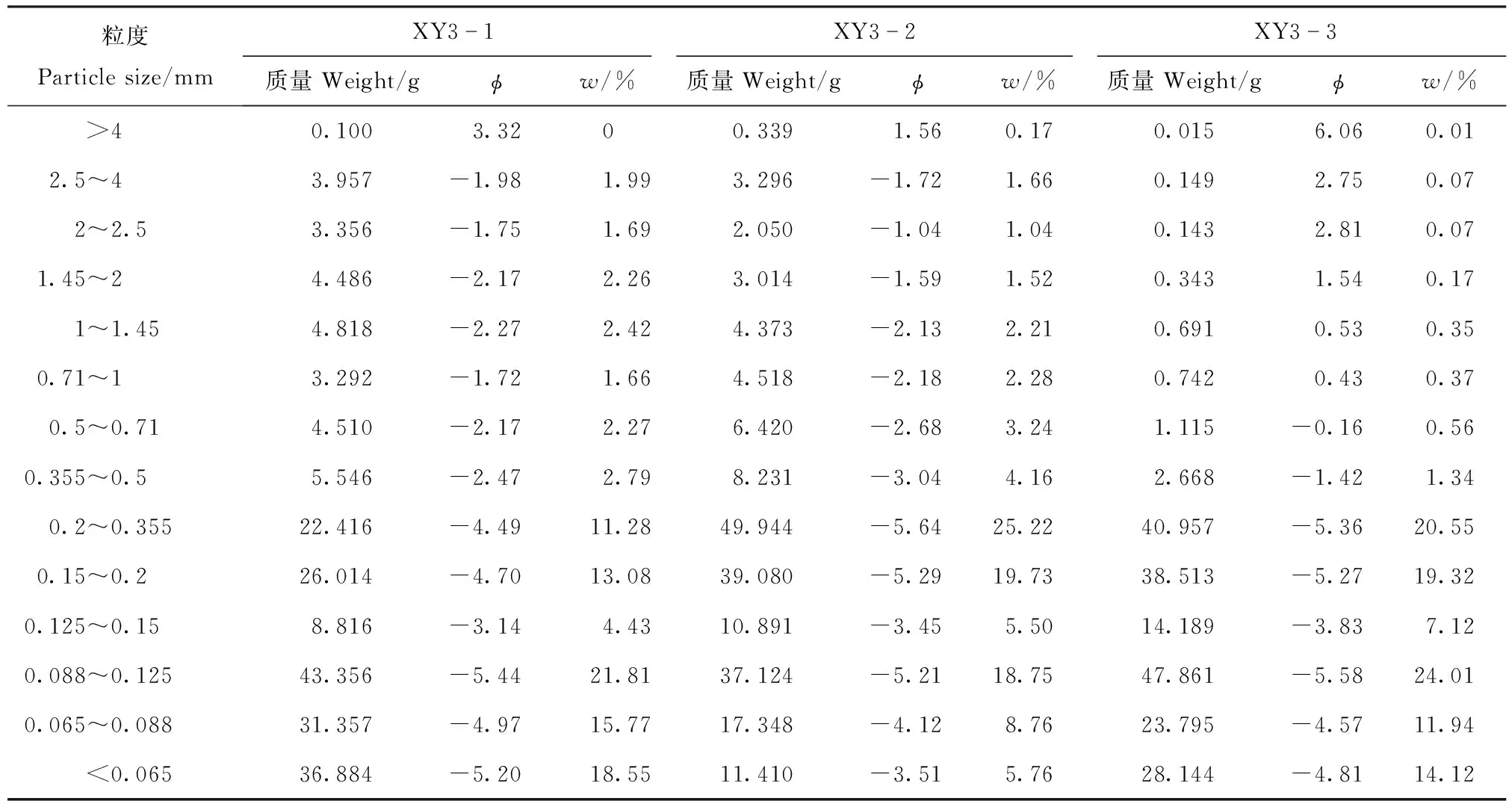
表3 堆积物下游段颗粒
注:XY3-1~XY3-7表示下游各采样点的编号。Note: XY3-1~XY3-7: the No. of sample points in the downstream section.

表4 堆积物各段的粒度比例
从以上各段粒度组成来看,溃坝堆积体的上游段主要是以粗大砾石堆积为主,水动力条件很强,导致粗大的砾石快速堆积下来而非砾石组分的粒度被迅速冲走。结合野外实地考察,上游段堆积物粒度较大,松散破碎,磨圆度较差,说明在溃决时没有经过长距离的搬运就快速沉积下来。离溃坝口较远的堆积体中游段和下游段出现细粒部分,说明这些物质在溃决时强水动力条件下,没来得及沉积就被冲下来,随后随着搬运距离延长,水动力条件逐渐变弱,导致部分才开始沉积,而这些细粒部分的沉积物质有可能来自不同的物源,一部分可能来源于坝体本身,有的可能来源于未溃决前上游的湖相沉积层,而这些松散、杂乱等大的粒度应该来自坝体本身的物质。
3.2粒度分布曲线
上游段粒度组成分布曲线图呈现明显的单峰型(图3),曲线为正偏的非对称分布,堆积物的众值粒度出现在φ值为-1.2附近,斜率很大,说明粒度比较集中。φ值为-2附近的粒度比例最高,达65%,其他比例均<8%,说明此段主要以砾石为主。
图3表明当时溃决时水动力条件极强,导致粗大的砾石快速堆积下来而非砾石组分的粒度被迅速冲走,沉积分选出来的物质比较单一,说明当时受单一稳定的水动力条件影响;将这些沉积细粒物质与坝体物质比较,得出这些砾石主要来源于坝体。
中游段粒度组成分布曲线图呈现明显的多峰型(图4),堆积物的众值粒度主要出现在φ值为2.5附近,φ值为3.5附近的次之,而砂粒部分比例高达32%,主要由细砂和极细砂为主,其他粒度比例均<10%,说明此段主要以细砂和极细砂为主,同时伴有少量的砾石及粗砂。
图4表明当时从堆积物上游段未沉积完的部分砾石还在沉积,细粒也开始有所沉积,细粒部分只是较溃坝堆积体上游段有所增加,但比下游段沉积较少。总的来说,中游段较上游段的水动力强度弱了,其中沉积的细粒并非全部来自坝体本身,有些可能来自堰塞湖溃坝前的上游湖相沉积。
下游段粒度组成分布曲线图呈现明显的双峰型(图5),堆积物的众值粒度主要出现在φ值为2.5附近,以φ值为2.5附近的粒度比例最高,高达37%,φ值为3.6附近的次之,主要由细砂和极细砂为主,其他区间的粒度砾石比例不足5%,说明此段主要以细砂和极细砂为主。虽然此段与中游段物质组成上相似,但细砂与极细砂的比例比中游段分别提高6%,同时少量的砾石及粗砂的比例比中游段减少6%。
以上对图5的粒度分布曲线分析可知,频率曲线属于双峰型且沉积物主要是细粒,并且细粒部分的含量较堆积体中游段部分增加很多。总的来说溃坝堆积体下游段的水动力强度较上游段和中游段更弱;但从这些沉积细粒物质与坝体物质关系角度来看,并非全部来自坝体本身,有可能这些细粒物质来自于堰塞湖溃坝前的上游湖相沉积。
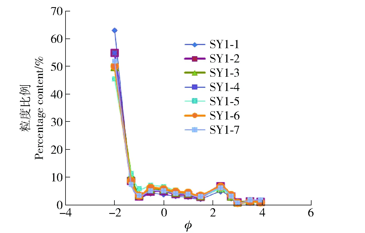
图3 上游粒度频率曲线Fig.3 Frequency curves of grain sizes in the upstream section
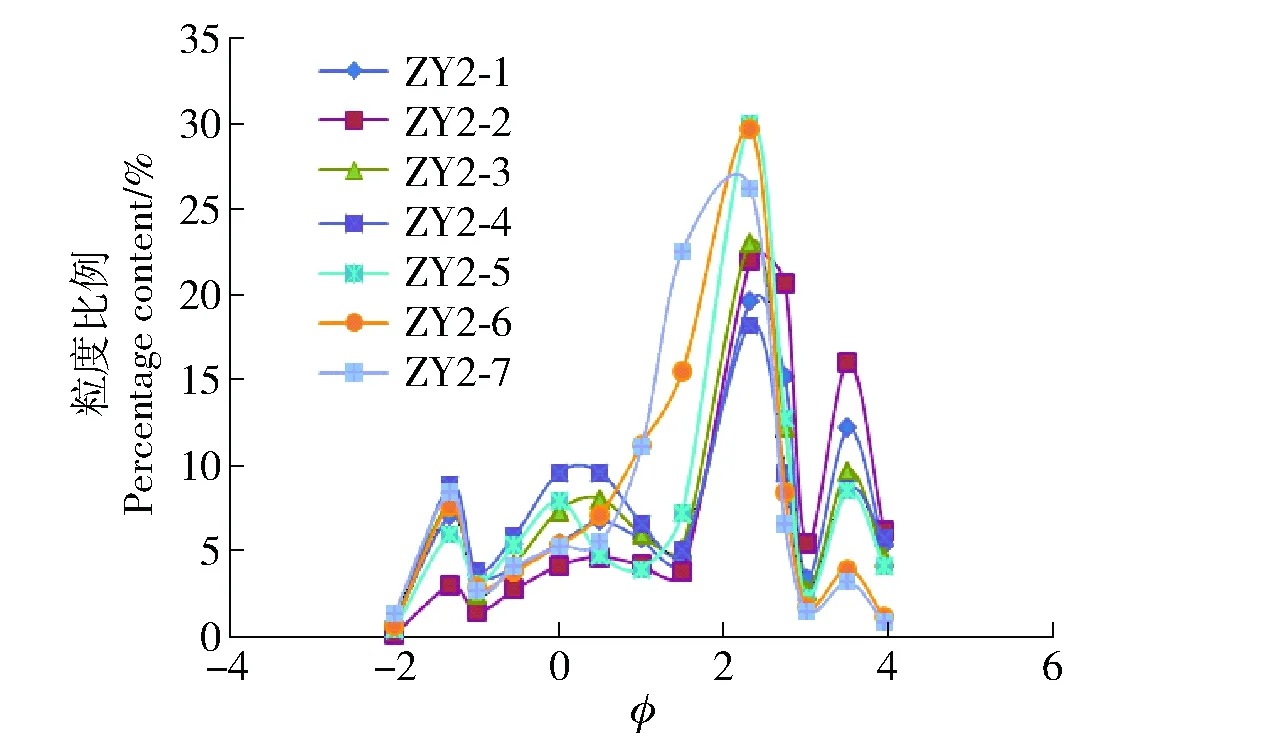
图4 中游段粒度频率曲线Fig.4 Frequency curves of grain sizes in the middle section
图5 下游粒度频率曲线Fig.5 Frequency curves of grain sizes in the downstream section
4结论与讨论
1)从金沙江上游雪隆囊溃坝堆积物粒度组成及其各段的频率分布曲线可以得出:上游段频率曲线为单峰,以砾石为主,溃决时水动力条件极强,且受单一稳定的水动力条件的影响,其中这些砾石主要来自坝体;中游段频率曲线为多峰型,主要以细砂和极细砂为主,水动力强度较上游有所减弱;下游段频率曲线为双峰型,主要以细砂和极细砂为主,相比中游比例增多,水动力强度比中游更弱了。其中中游段与下游段沉积的细粒部分并非全部来自坝体本身,有些可能来自于堰塞湖溃坝前的上游湖相沉积。
2)总体而言,水动力条件由上到下在逐渐减弱。就堆积体与堰塞湖坝体的物质关系来说,砾石部分来自坝体物质,而细粒部分可能部分来自坝体,部分来自堰塞湖溃坝前上游的湖相沉积层。
3)金沙江上游溃坝堆积物的粒度分布曲线与前人所研究的风成砂丘—海(湖)滩砂—河道砂—冰川和冲积扇等特点进行对比,更趋向于河道堆积物的粒度分布曲线。
5参考文献
[1]孙有斌,高抒,李军. 边缘海陆缘物质中环境敏感粒度组分的初步分析[J]. 科学通报,2003,48(1):83.
Sun Youbin, Gao Shu, Li Jun. Preliminary analysis of environmental sensitive grain size group edge material sea margin[J]. Science Bulletin,2003,48(1):83.(in Chinese)
[2]肖景义,陈建强,孙刚,等. 河北邯郸HZ- S孔第四纪沉积物粒度特征分析[J]. 干旱区资源与环境,2009,23(1):54.
Xiao Jingyi, Chen Jianqiang, Sun Gang, et al. Grain-size characteristics of HZ-S core Quaternary sediments in Handan city, Hebei province[J]. Journal of Arid Land Resources and Environment, 2009,23(1):54. (in Chinese)
[3]吕连清,方小敏,鹿化煜,等. 青藏高原东北缘黄土粒度记录的末次冰期千年尺度气候变化[J].科学通报,2004,49(11):1091.
Lü Lianqing, Fang Xiaomin, Lu Huayu, et al. Grain size records of loess grain size of millennium scale climate change in the northeastern margin of the Tibet Plateau during the last glacial period[J]. Science Bulletin,2004,49(11):1091. (in Chinese)
[4]殷志强,秦小光.中国北方部分地区黄土、沙漠沙、湖泊、河流、细粒沉积物粒度多组分分布特征研究[J].沉积学报,2009,27(2):344.
Yin Zhiqiang, Qin Xiaoguang. The multimodal grain-size distribution characteristics of loess, desert, lake and river sediments areas of Northern China[J]. Acta Sedimentologica Sinica,2009,27(2):344.(in Chinese)
[5]李昌志,王裕宜.泥石流、冰碛和河湖沉积物的粒度特征及判别[J].山地学报,1999,17(1):50.
Li Changzhi, Wang Yuyi. Prelimilary exploration on grain characteristic and discrimination of debris flow deposit, moraine and river & lake deposit[J]. Journal of Mountain Science,1999,17(1):50.(in Chinese)
[6]刘富刚.鲁西北地表沉积物粒度特征及分布成因研究[J].人民黄河,2008,30(7):12.
Liu Fugang. Study on grain size characteristics and distribution of surface sediments in the northwest of Shandong Province[J].Yellow River,2008,30(7):12.(in Chinese)
[7]董智,王丽琴,杨文斌,等.额济纳盆地戈壁沉积物粒度特征分析[J].中国水土保持科学,2013,11(1):32.
Dong Zhi, Wang Liqin, Yang Wenbin, et al. Grain size characteristics of gobi sediment in Ejina Basin[J]. Science of Soil and Water Conservation,2013,11(1):32.(in Chinese)
[8]史兴民,万正耀,师静.渭河咸阳段近代洪水沉积物粒度特征分析[J].水土保持通报,2008,28(3):71.
Shi Xingmin, Wan Zhengyao, Shi Jing. Grain-size characteristics of recent flood sediment of Weihe River in Xianyang section[J]. Bulletin of Soil and Water Conservation,2008,28(3):71.(in Chinese)
[9]李柏,高甲荣,胡封兵,等.北京王虎沟泥石流堆积物粒度参数分析[J].中国水土保持科学,2011,9(4):7.
Li Bai, Gao Jiarong, Hu Fengbing, et al. Granularity parameter of debris flow deposit in Wanghugou Gully,Beijing City[J]. Science of Soil and Water Conservation, 2011, 9(4): 7.(in Chinese)
[10] 易顺民,唐辉明. 冻土粒度成分的分形结构特征及其意义[J]. 冰川冻土,1994,16(4):314.
Yi Shunmin, Tang Huiming. Fractal structure features of granulometric composition in frozen soil and its significance[J]. Journal of Glaciolgy and Geocryolong, 1994, 16(4): 314. (in Chinese)
[11] 柏春广,王建. 一种新的粒度指标:沉积物粒度分维值及其环境意义[J]. 沉积学报,2003,21(2):234.
Bai Chungunag, Wang Jian. A new grain-size index: grain-size fractal dimension of sediment and its environmental signif icance[J]. Acta Sedimentologica Sinica, 2003, 21(2): 234. (in Chinese)
[12] 张宏,柳艳华,杜东菊. 渤海湾西岸沉积物粒度参数特征及其工程性质分析[J]. 天津城市建设学院学报,2007,13(2):104.
Zhang Hong, Liu Yanhua, Du Dongju. Analysis of characters of granularity parameters and engineering properties of sediments in western coast of Bohai Bay[J]. Journal of Tianjin Institute of Urban Construction, 2007, 13(2): 104. (in Chinese)
[13] Evans S G.The maximum discharge of outburst floods caused by the breaching of man-made and natural dams[J].Canadian Geotechnical Journal,1986,23:385.
[14] Cutler P M,Colgan P M,Mickelson D M.Sedimentologic evidence for outburst floods from the Laurentide Ice Sheet margin in Wisconsin,USA: implications for tunnel-channel formation[J].Quaternary International,2002,90(1):23.
[15] Benn D I,Owen L A,Finkel R C, et al.Pleistocene lake outburst floods and fan formation along the eastern Sierra Nevada,California: implications for the interpretation of intermontane lacustrine records[J].Quaternary Science Reviews,2006,25(21/22):2729.
[16] Lord M L, Kehew A E.Sedimentology and paleohydrology of glacial-lake outburst deposits in southeastern Saskatchewan and northwestern North Dakota[J].Geological Society of American Bulletin,1987,99(5):663.
[17] Dai F C,Lee C F,Deng J H,et al.The 1786 earthquake triggered landside dam and subsequent dam-break flood on the Dadu River,Southwestern China[J].Geomorphology,2005,65(3/4):205.
[18] 吴庆龙,张培震,张会平,等.黄河上游积石峡古地震堰塞溃决事件与喇家遗址异常古洪水灾害[J].中国科学(D辑):地球科学,2009,39(8):1148.
Wu Qinglong, Zhang Peizhen, Zhang Huiping, et al. The Jishixia ancient earthquake damming outburst on the upper reaches of the Yellow River and the Lajia ancient abnormal flood disaster[J]. Science in China (Series D: Earth Sciences), 2009, 39(8): 1148. (in Chinese)
[19] 崔之久,张梅,崔鹏,等. 初论堰塞湖溃坝沉积相特征[J]. 山地学报,2015,33(2):129
Cui Zhijiu, Zhang Mei, Cui Peng, et al. Discussion on characteristics of sedimentary facies of dammed-lakes outburst deposit[J]. Mountain Research, 2015, 33(2): 129. (in Chinese)
[20] 王兰生,杨立铮,王小群,等.岷江叠溪古堰塞湖的发现[J].成都理工大学学报:自然科学版,2005,32(1):1.
Wang Lansheng, Yang Lizheng, Wang Xiaoqun, et al. Discovery of huge ancient dammed lake on upstream of Minjiang River in Sichuan, China[J]. Journal of Chengdu University of Technology: Science & Technology Edition, 2005, 32(1): 1. (in Chinese)
[21] 王小群,王兰生,沈军辉.岷江上游叠溪古堰塞湖沉积物粒度特征及环境意义[J].工程地质学报,2010,18(5):677.
Wang Xiaoqun, Wang Lansheng, Shen Junhui. Granularity analysis of sediments in Diexi ancient dammed lake on the upstream of Minjiang River and its environmental significance[J]. Journal of Engineering Geology, 2010, 18(5): 677. (in Chinese)
[22] 王光谦,钟德钰,张红武,等.汶川地震唐家山堰塞湖泄流过程的数值模拟[J].科学通报,2008,53(24):3127.
Wang Guangqian, Zhong Dejue, Zhang Hongwu, et al. The numerical simulation of discharge process of the Tangjiashan Quake Lake formed by the Wenchuan Eathquake[J]. Chinese Science Bulletin, 2008, 53(24): 3127. (in Chinese)
[23] 傅旭东,刘帆,马宏博,等.基于物理模型的唐家山堰塞湖溃决过程模拟[J].清华大学学报(自然科学版),2010,50(12):1910.
Fu Xudong, Liu Fan, Ma Hongbo, et al. Physically based simulation of the breaching of the Tangjiashan Quake Lake[J]. Journal of Tsinghua University(Science and Technology), 2010, 50(12): 1910.(in Chinese)
[24] 王小群,王兰生,崔杰.金沙江乌东德水电站岸坡槽谷堆积体成因分析[J].水文地质工程地质,2008(5):7.Wang Xiaoqun,Wang Lansheng,Cui Jie.Causes analysis of slope accumulation in Wudongde hydropower station of Jinshajiang river valley[J].Hydrogeology & Engineering Geology,2008(5): 7.(in Chinese)
[25] 崔杰,王兰生,徐进,等.金沙江中游滑坡堵江事件及古滑坡体稳定性分析[J].工程地质学报,2008,16(1):6.
Cui Jie,Wang Lansheng,Xu Jin,et al.Stability analysis of old landslide for a possible ancient landslide event blocking middle of Jinsha river[J].Journal of Engineering Geology,2008,16(1): 6.(in Chinese)
[26] 石豫川,等.金沙江上游某巨型复合型滑坡的基本特征及稳定性分析[J].地质灾害与环境保护,2003,14(4):11.
Shi Yuchuan, et al. The basic characteristics and stability analysis to some giant and multiple landslide in upper course of Jinsha river[J].Journal of Geological Hazards and Environment Preservation,2003,14(4): 11.(in Chinese)
[27] 陈剑,崔之久.金沙江上游雪隆囊古滑坡堰塞湖溃坝堆积体的发现及其环境与灾害意义[J].沉积学报,2015,33(2):275.
Chen Jian, Cui Zhijiu. Discovery of outburst deposits induced by the Xuelongnang paleolandslide-dammed lake in the upper Jinsha River, China and its environmental and hazard significance[J]. Acta Sedimentologica Sinica, 2015, 33(2): 275. (in Chinese)
[28] Krumbein W C. Measurement and geological significance of shape and roundness of sedimentary particles[J].Journal of Sedimentany Research,1941,11(2):64.
(责任编辑:程云郭雪芳)
Granularity characteristics of deposits from the break of the dammed lake caused by Xuelongnang ancient landslide in the upper Jinsha River
Chen Song, Chen Jian, Liu Chao, Ma Junxue
(School of Engineering and Technology, China University of Geosciences, 100083, Beijing, China)
Abstract:[Background] The upper reaches of Jinsha River is a geological disaster prone area, and the geological environment evolution is relatively complex. [Methods] To study the relationship among the source of deposits after the break of dammed lake, the materials in the dam-body and sedimentary environment, taking the dam-break deposits from the dammed lake caused by Xuelongnang ancient landslide in the upper Jinsha River as the main research object, through field survey sampling and indoor sieving test of particle size, the particle sizes were tested, the granularity characteristics in the upstream, middle, and downstream section of the deposits were studied, and the composition of grain size and the size distribution curve of the deposits were analyzed in detail. [Results] The results showed that the distribution curves of grain sizes in the dam-break deposits for the upstream, middle and the downstream sections were unimodal, multimodal and doublet respectively. The composition of the grain size in the upstream section mainly was gravel, the hydrodynamic intensity was very strong, and it was affected by the single stable hydrodynamic condition. In the middle section, the main ones were fine sand and extremely fine sand, hydrodynamic intensity weakened mainly in the lower reaches. Compared with middle section, also main sizes in downstream were also fine and extremely fine, and the proportion of them increased; moreover, hydrodynamic intensity was even weaker in general. Regarding the relationship between deposits and materials of dam-body, the gravels were from the material of dam-body, and the fine particles might be partly from the dam-body, and partly from the lacustrine sediment in the upper reaches before the break of dammed lake. The particle size presented the trend of obvious becoming thinner from the upstream to the downstream, and the average particle size changed from coarse to fine. The sorting feature of dam-break deposits was poorer and poor. These characteristics reflected the gradual weakening of hydrodynamic intensity from upstream to downstream of dam-break deposits. Contrast to the characteristics of the wind sand dune-sea (lake) beach sand - river sand-glacial and alluvial fan, etc. studied previously, the size distribution of dam-break deposits in the upstream of Jinsha River had high similarity with the grain size distribution curve of the river deposits. [Conclusions] Therefore, to reveal the granularity characteristics and change pattern of the deposits, studying the relationships among the sources of deposits from break of dammed lake, the material composition of dam-body and sedimentary environment is of great significance, which may provide reference value for the management of soil and water conservation in the upper reaches of Jinsha River in the future.
Keywords:Xuelongang; ancient landslide; deposits; granularity characteristics; Jinsha River
收稿日期:2015-09-13修回日期: 2016-01-11
第一作者简介:陈松(1989—),男,硕士研究生。主要研究方向:工程地质与地质灾害防治。E-mail:chennsongg@163.com †通信 陈剑(1975—),男,副教授。主要研究方向:灾害地貌学、工程地质和地质灾害防治。E-mail:jianchen@cugb.edu.cn
中图分类号:P642.5
文献标志码:A
文章编号:1672-3007(2016)01-0028-08
DOI:10.16843/j.sswc.2016.01.004
项目名称: 国家自然科学基金重点项目“青藏高原第四纪冰碛旋回与构造隆升藕合机制及过程研究”(41230743);国家自然科学基金面上项目“堰塞坝、湖及溃坝堆积地貌过程与沉积特征的综合研究”(41571012);中央高校基本科研业务费专项资金资助项目“中国西南地区古滑坡坝的形成与演化过程”(2652015060)