Toward sustainable desertification reversion:A case study in Horqin Sandy Land of northern China
2015-12-19XueYongZhaoShaoKunWangYaYongLuoWenDaHuangHaoQuJieLian
XueYong Zhao ,ShaoKun Wang,YaYong Luo,WenDa Huang,Hao Qu,Jie Lian
Naiman Desertification Research Station,Cold and Arid Regions Environmental and Engineering Research Institute,Chinese Academy of Sciences,Lanzhou,Gansu 730000,China
1 Introduction
Desertification is land degradation in arid,semi-arid,and dry sub-humid areas resulting from adverse human impact."Land" in this concept includes soil and local water resources,land surfaces,and vegetation or crops."Degradation" implies reduction of the resource potential by one or a combination of processes acting on the land,including water and wind erosion,sedimentation and siltation,long-term reduction in the level of diversity in natural vegetation,crop yields,soil salinization,and sodication(Rozanov,1990;UNEP,1990).
Desertification is considered one of the major ecological and environmental threats at present,along with climate change,resource depletion,and pollution and land degradation.Desertification is also closely related to poverty and social inequality.According to a 2012 report by the United Nations Environment Programme(UNEP,2012),there are about 1 billion people in 100 countries affected by desertification,and 50% of the land in western Africa is desertified.China has undergone severe desertification in the past 50 years,with 2.62 million km2of land degraded,of which 38.57×10⁴km2has become desertified(Wang,2007).
Horqin Sandy Land was once one of the four major grasslands in northeastern China,and has been severely desertified since the mid-1950s.The desertified land area increased from the 1960s to the 1980s and then decreased from the 1990s onward.The water availability has decreased simultaneously,characterized by reduction of underground water tables,drying-up of lakes and rivers,and increased difficulty in restoration of degraded vegetation(Zhaoet al.,2010).We raised the following questions:(1)Is the reduction of water availability related to desertification reversion?(2)Is it possible to promote sustainable desertification reversion in Horqin Sandy Land?Therefore,we systematically assessed the changes in precipitation,desertified land areas,land uses,and water availability to describe the relationships between these factors to pursuit of sustainable desertification reversion.
The following definitions are listed in the side bar to compare the different meanings of "desertification"by international researchers and for better understanding of the nuanced differences in these critical definitions between the international and Chinese researchers.

International Definitions of Desertification Desertification has different meanings for different people,and a variety of definitions and concepts of desertification exist.The United Nations adopted the somewhat vague definitions of desertification presented at the United Nations Conference on Desertification(UNCOD)in 1977,and they are the most commonly used.Some examples with similar meanings dating from the mid-1970s are as follows:·Desertification is the diminution or destruction of the biological potential of the land,and can lead ultimately to desert-like conditions(UNCOD A/CONF 74/36,1977b).·Desertification can be described as a process of impoverishment of arid,semi-arid,and some sub-humid ecosystems by the combined impacts of man's activities and drought(Dregne,1976).·Desertification has been defined as a process leading to reduced biological productivity,with consequent reduction in plant biomass,in the land's carrying capacity for livestock,in crop yields and human wellbeing leading to the intensification or extension of desert conditions(UNCOD A/CONF 74/2,1977a).·Desertification(desertization)was defined as the spread of desert-like conditions in arid or semi-arid areas due to man's influence or climatic change(Rapp,1978).In mid-1991,after having considered recent findings about the influence of climatic fluctuations and the resilience of soils,and taking into account the results of additional studies and consultation under taken by UNEP,the following definition was finally adopted by UNEP for the preparation for the United Nations Conference on Environment and Development(UNCED)in Brazil(UNEP,1991):·Desertification is land degradation in arid,semi-arid and dry sub-humid areas resulting mainly from adverse human impact.This definition is adopted by this paper.
None of these definitions refers to desertification reversion,let alone sustainable desertification reversion taking water resources as a limiting factor.Sustainable desertification reversion means that desertification reversion is implemented without compromising the basic resource capacity for ecosystem succession and economic development in the targeted region.Climate models predict that the frequency and severity of drought and extreme weather events will increase globally over the next century(Seageret al.,2007;Allisonet al.,2009).Increased land use change plays an important role in desertification development and reversion.
2 Materials and methods
2.1 Site
This research was carried out in Naiman County,which covers 8,200 km2and is located in the central part of Horqin Sandy Land of 12,900 km2.Horqin Sandy Land is one of the most severely desertified lands in the agro-pastoral transitional region in northeastern Inner Mongolia,China,and Naiman County is even more severely desertified.Since the mid-1980s,however,desertification has been reversed with great efforts in protection,conservation,restoration,and utilization of the degraded grassland by the local people and governments at all levels.Nevertheless,this reversion is now being challenged by rapid land-use change,water availability reduction,and decreased reversion rate.Water availability reduction is mainly caused by increasing use of water for cropland and revegetated sand land irrigation,while precipitation has decreased in recent years(Zhaoet al.,2010).
2.2 Methodology
We obtained climate data from the data bank of the Naiman Desertification Research Station(NDRS),Chinese Ecosystems Research Network.Land use data were obtained from the Statistical Annual Report of Tongliao and Chifeng and crosschecked with TM images interpreted with ARCGIS 11.Underground water table change is based on the data of long-term monitoring by NDRS.All data were analyzed and presented with Excel 2007 and SPSS 17.
3 Results
3.1 Climate change
Precipitation is one of the primary sources of water in arid and semi-arid regions,and climate change includes not only precipitation but also air temperature,which further influences evapotranspiration leading to more severe water limitation.
It is quite clear that there was a dramatic fluctuation in precipitation in the period of 1975 to 2000 in this region.The maximum was 567.1 mm in 1986 and the minimum was 212.8 mm in 2002.The air temperature change was relatively moderate,with a general increasing trend over time.The average air temperature was 6.25 °C in the 1960s,6.29 °C in the 1970s,6.80 °C in the 1980s,7.50 °C in the 1990s,and 6.70 °C from 1991 to 2009.This was an increase of 0.50 °C to 1.25 °C from the 1960s to the 2000s in Naiman County(Figure 1).
Another striking characteristic was a more moderate change of the maximum air temperature and a growing fluctuation of the minimum air temperature,with an approximately 10 °C discrepancy between the high and the low as well as an increase of about 1 °C in the mean air temperature.
3.2 Desertified land change
From Figure 2,it is quite clear that the desertified land area increased from 42,300 km2in 1959 to 61,000 km2in 1985,and then declined to 51,000 km2in 2010,the latter almost equals to that in 1975 and 2000.It is noticeable that desertification reversion slowed down from 2000 to 2010 in Horqin Sandy Land.However,in Naiman County the desertified land area gradually reduced from 5,657.12 km2in 1975 to 5,409.63 km2in 1987,and to 4,505.84 km2in 2000 and then to 4,405.32 km2in 2010.The reduction of desertified land from 2000 to 2010 was much lower,indicating that desertification reversion is,in a sense,getting more difficult.

Figure 1 Annual precipitation(a)and air temperature(b)in Naiman County,Horqin Sandy Land.Mean = mean annual air temperature(°C),Max = annual mean maximum air temperature(°C),Min = annual mean minimum air temperature(°C)
In summary,desertified land in Horqin Sandy Land increased from 1959 to the mid-1980s,and then decreased from 1985 to 2000 and again to 2010.The small difference between 2000 and 2010 indicates that desertification reversion was quite possibly retarded due to increasing limitation of water resources or was compromised by redesertification of restored or newly desertified land.
3.3 Cropland change
The aboriginal land cover isUlmus pumilascattered grassland in Naiman County.Cropland invasion is the greatest change of land use in this region and is why land use change.Cropland invasion,together with precipitation decrease,are identified as the primary driving force of desertification(Zhu and Chen,1994).It is quite evident that there has been a rapid and almost consistent increase of irrigated cropland,while the amount of total cropland has fluctuated and generally decreased,with a larger proportion of rainfed cropland(discrepancy between the total and irrigated cropland in Figure 3).
The irrigated cropland increased from 0 ha in 1947 to 63,390 ha in 2010,while the total cropland increased from 94,000 ha in 1947 to 137,220 ha in 1960,then decreased to 59,500 ha in 1995,and then fluctuated for a short period and increased to 124,060 ha in 2010.Irrigated cropland change is one of the causes of underground water table decrease(Zhuet al.,1984,1994;Zhao,2005).
Considering the cropland change in the later period of 2001 to 2012,the irrigated cropland change is well modeled with the polynomial equation shown in Figure 3b,but the total cropland is not;it is further discussed in Section 4 below.
3.4 Water availability change
Water is the key limiting factor for desertification reversion and sustainable land use in Naiman County.Although reduction of annual precipitation is regarded as the primary factor leading to the reduction of water availability,and this has compromised the efforts to combat desertification(Figure 2),the increasing amount of total cropland is also important in explaining the decreasing reversion rate of desertification in Horqin Sandy Land(Zhaoet al.,2010).
Water availability should be expressed as the availability of precipitation,ground water such as lakes,rivers,and wetlands,as well as underground water.
From Figure 4,it is evident that the water body area in Naiman County has decreased from the mid-1980s to the present.This process is fairly covariant with irrigated cropland change,precipitation reduction,and the decline in the desertification reversion rate(Figures 1,2,and 3),as well as reduction of ground water tables(Zhaoet al.,2010;Lianet al.,2013).
3.5 Relationships between desertified land and key factors
In order to reveal the relationships among desertified land,underground water table,irrigated cropland,total cropland,and annual precipitation,we performed a stepwise correlation analysis.This showed that the underground water table is significantly and negatively related to the annual precipitation(P=0.01;-0.466)and the irrigated cropland(P=0.01;-0.629).There is a non-significantly positive relationship between desertified land and the annual precipitation(0.333)and the underground water table(0.553).The correlation between desertified land and total cropland is significant(P=0.05;0.900),and this coincides with previous related researches.
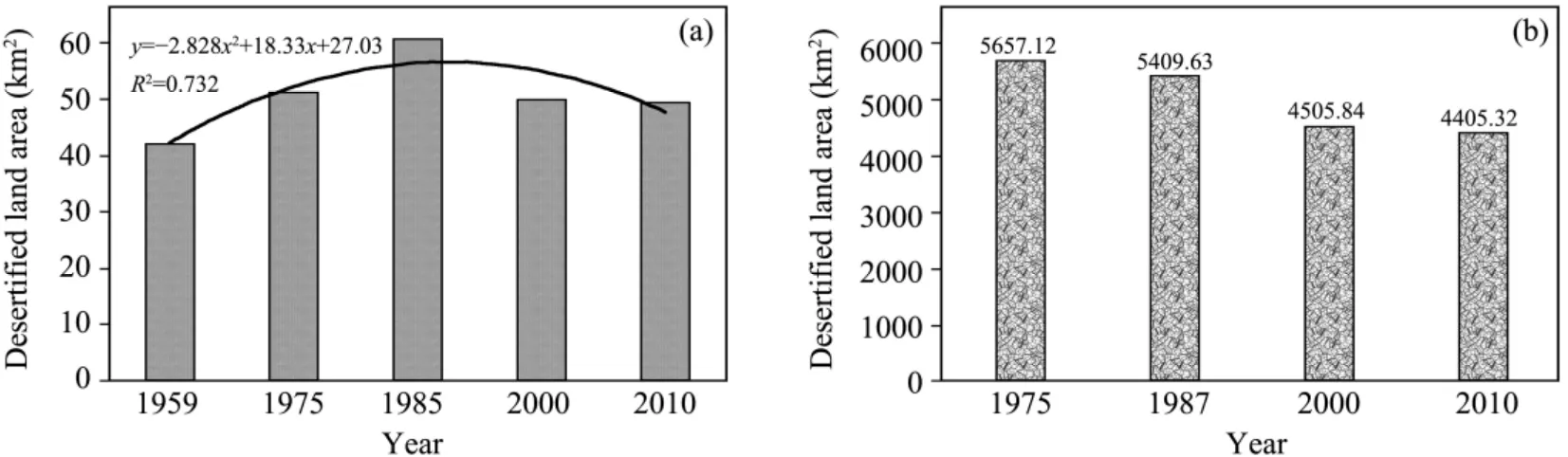
Figure 2 Desertified land area in Horqin Sandy Land(a)and Naiman County(b)

Figure 3 (a)Cropland change in Naiman County;(b)Detail of the years 2001-2012
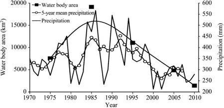
Figure 4 Change of water body area contrasted with annual precipitation
4 Discussion
Precipitation is the major water source of Naiman County and plays a key role in desertification reversion(Zhu and Chen,1994).From the above results(Figure 1),the long-term average precipitation in this region is 350-500 mm/a and declined to less than 300 mm in most of the years after 1998.This change was coincident with the prediction of climate change by Qin(2002),whose research predicted that the vast region east to the Helan Mountains,including Horqin Sandy Land,would become drier and warmer.
Cropland invasion is another driving force leading to desertification in Horqin Sandy Land.According to theAnnals of Naiman County(2007),there was no cropping up to 1872,when the then Qing government adopted the land usePolicy of Prohibiting Reclamationin Mongolian grassland(mostly referring to the Inner Mongolian Region)right at the southeastern edge of the Eurasian Grassland.After 1872,farmers from the surrounding provinces swarmed into Mongolian grasslands and cropping activities prevailed over this region,and desertified land expanded rapidly(Zhu and Chen,1994;Brogaard and Zhao,2002).As discussed in connection with Figure 3b above,the irrigated cropland change is well modeled with a polynomial equation but the total cropland is not,quite possibly due to the fact that irrigated cropland change is more influenced by population,land use policy,and management(Brogaard and Zhao,2002).
Cropland increase,particularly irrigated cropland increase,is one of the causes of reduction in water availability,characterized by increase of underground water depth and decrease of water body areas in Naiman County(Figure 4).Long-term monitoring has shown that the irrigation water needed for one hectare of corn in Naiman County is about 1,080-1,200 m3,and in some villages is more than 1,620 m3/ha.The total water amount consumed for one hectare of corn in a year is 7,560-8,400 m3(Zhao,2005).
Desertification reversion is achieved by planting trees and shrubs on shifting and semi-shifting dunes for promoting revegetation of degraded grassland,as well as changing rainfed cropland into intensively irrigated cropland or grassland.However,in recent years it has been very difficult for planted trees and even bushes to survive due to climate change and the increasing depth of underground water tables,far beneath the reach of plant roots.One hectare ofPopulus simoniitrees requires 5,250-7,500 m3of water every year to survive,nearly equal to the water consumed by an equal area of corn(Zhao,2005).Therefore,in order to cope with climate change and achieve sustainable desertification reversion,it is definitely necessary to adopt systematic measures to improve water availability,such as adoption of aboriginal plant species for revegetation,sparsely tree-scattered grassland restoration and water-saving techniques for crop irrigation.
5 Conclusions
Our analyses demonstrate that desertification in Naiman County and Horqin Sandy Land has been reversed,but the reversion is being compromised by the reduction of water availability.The latter is mainly caused by decreasing precipitation and increasing water use for cropland and irrigation for revegetation,which is identified as the leading cause of ground water reduction.
Precipitation is the major water source of Naiman County and plays a key role in desertification reversion and maintaining water availability.However,the annual precipitation decreased in the past 15 years.
Cropland invasion is another driving force leading to desertification in Horqin Sandy Land.Cropland increase,particularly irrigated cropland increase,is one of the causes of reduction of water availability characterized by the decrease of underground water tables and water body areas in Naiman County.
Sustainable desertification reversion is a strategic target for Horqin Sandy Land and Naiman County to promote sustainable socio-economic and natural ecosystem development.
This research is funded by the National Pivotal Project,Nos.2011BAC07B02 and 201109025(2),and NSFC Project No.41071185.
Allison I,Bindoff NL,Bindschadler RA,et al.,2009.The Copenhagen Diagnosis:Updating the World on the Latest Climate Science.Sydney,Australia:The University of New South Wales Climate Change Research Centre(CCRC).
Brogaard S,Zhao XY,2002.Rural reforms in land management and attitudes:A case study from Inner Mongolia,China.Ambio,31(3):219–225.
Dregne HE,1976.Desertification:Symptom of a crisis.In:Reining P(ed.).Handbook on Desertification Indicators Based on the Science Association's Nairobi Seminar on Desertification,Washington D.C.:American Association for the Advancement of Science(AAAS),pp.141.
Editing Committee of Naiman County Annals,2007.Annals of Naiman County.Hohhot:Inner Mongolia Press.
Lian J,Zhao XY,Zuo XA,et al.,2013.Land cover changes and the effects of cultivation on soil properties in Shelihu wetland,Horqin Sandy Land,Northern China.Journal of Arid Land,5(1):71–79.DOI:10.1007/s40333-013-0143-5.
Qin DH,2002.Assessment of the Environmental Change in Western China.Beijing:Science Press.
Rapp A,1978.A Review of Desertization in Africa:Water,Vegetation and Man.Lund,Sweden:Department of Physical Geography,University of Lund.
Rozanov BG,1990.Global assessment of desertification:Status and methodologies.In:Desertification Revisited:Proceedings of an Ad Hoc Consultative Meeting on the Assessment of Desertification.UNEP-DC/PAC,Nairobi,pp.45–122.
Seager R,Ting MF,Held I,et al.,2007.Model projections of an imminent transition to a more arid climate in southwestern North America.Science,316(5828):1181–1184.DOI:10.1126/science.1139601.
UNCOD A/CONF 74/2,1977a.World map of desertification.Document of the UN Conference on Desertification in Nairobi.Nairobi,Kenya.
UNCOD A/CONF 74/36,1977b.Plan of action to stop desertification.Report of the UN Conference on Desertification in Nairobi.Nairobi,Kenya.
United Nations Environment Programme(UNEP),1990.Report on ad hoc consultation meeting assessment of global desertification:status and methodologies.Nairobi,Kenya.
United Nations Environment Programme(UNEP),1991.Status of desertification and implementation of the United Nations Plan of Action to Combat Desertification.Draft Report,UNEP,Nairobi,pp.14.
United Nations Environment Programme(UNEP),2012.2012 Annual Report.Nairobi,Kenya.
Wang T,2007.The status of aeolian desertification and its control in China.Chinese Journal of Nature,29(4):204–210.
Zhao XY,2005.Responses of Ecosystems to Land Use Changes in Horqin Sand Land.Ph.D Dissertation,University of Chinese Academy of Sciences.
Zhao XY,Wang SK,Luo YY,et al.,2010.Is desertification reversion sustainable in Northern China? A case study in Naiman County,part of typical agro-pastoral transitional zone in Inner Mongolia,China.Global Environmental Research,14:63–70.
Zhu ZD,Chen GT,1994.Sandy Desertification in China.Beijing:Science Press.
Zhu ZD,Liu S,Yang YL,1984.The possibilities and realities on re-management of desertified lands in the inter-distributing areas for agricultural and graziery practices in northern China.Scientia Geographica Sinica,4(8):197–206.
杂志排行

Sciences in Cold and Arid Regions的其它文章
- Adaptation to climate change in desertified lands of the marginal regions in Egypt through sustainable crop and livestock diversification systems
- Land desertification and restoration in Middle East and North Africa(MENA)region
- Effects of sand burial on survival and growth of Artemisia halodendron and its physiological response
- A mechanism for the origin and development of the large-scale dunefield on the right flank of the lower reach of Laoha River,Northeast China
- Effects of dune stabilization on vegetation characteristics and soil properties at multiple scales in Horqin Sandy Land,Northern China
- Seasonal change mediates the shift between resource and pollen limitation in Hedysarum scoparium(Fabaceae)