Habitat evaluation for target species following deep-waterchannel project in the Yangtze River
2015-03-01XuSudongLiRuiYinKai
Xu Sudong Li Rui Yin Kai
(School of Transportation, Southeast University, Nanjing 210096, China)
Habitat evaluation for target species following deep-waterchannel project in the Yangtze River
Xu Sudong Li Rui Yin Kai
(School of Transportation, Southeast University, Nanjing 210096, China)
Abstract:In order to optimize the design of a 12.5 m deep-water channel project and protect the ecological environment, it is necessary to study the habitat evaluation of species in the engineered area. A coupled eco-hydrodynamic model, which combines a hydrodynamic model (ADCIRC) and a habitat suitability index (HSI) model is developed for target fish (Coilia nasus) and benthos (Corbicula fluminea) in the Yangtze River in order to predict the ecological changes and optimize the regulation scheme. Based on the existing research concerning the characteristics of Coilia nasus and Corbicula fluminea, the relationship between the target species and water environment factors is established. The verification results of tidal level, velocity and biological density show that the proposed coupling model performs well when predicting ecological suitability in the studied region. The results indicate a slight improvement in the potential habitat availability for the two species studied as the natural hydraulic conditions change after the deep-water channel regulation works.
Key words:deep-water channel project; hydrodynamic model; habitat suitability index; ecological engineering
Received 2015-07-27.
Biography:Xu Sudong (1980—), male, doctor, associate professor, sudongxu@seu.edu.cn.
Foundation items:The National Natural Science Foundation of China (No.51209040, 51279134), the Natural Science Foundation of Jiangsu Province (No.BK2012341).
Citation:Xu Sudong, Li Rui, Yin Kai. Habitat evaluation for target species following deep-water channel project in the Yangtze River[J].Journal of Southeast University (English Edition),2015,31(4):559-565.[doi:10.3969/j.issn.1003-7985.2015.04.022]
In recent years, the human impact on the river ecosystem has gained increasing concern. Human activities, such as dam construction, dredging, channel regulation, can affect the river patterns and thus leave a significant impact on the river ecosystem[1]. The number of local species may decline or disappear due to human disruption. A major alteration of the river ecosystem is the hydrodynamic change caused by spur dikes and submerged dikes. The spur dikes and submerged dikes affect the velocity, depth, and substrate distributions which can detrimentally alter the physical habitat. Hydrologic processes are interconnected with biological communities[2]. Therefore, it is necessary to analyze, assess and quantify the impact of channel regulation works. With the sustained and rapid growth of the national economy in the Yangtze River Delta, a 12.5 m deep-water channel project was required urgently to take advantage of the ports along the Yangtze River and the deep-water channels[3]. Spur dikes and submerged dikes were constructed with the necessary dredging to scarify the requirements of the navigation for large tonnages carriers. Therefore, it is necessary to select an effective method to assess the impact of human modifications on the surrounding species.
The habitat suitability index (HSI) model is one such way to monitor and predict changes in the ecosystem after channel regulation works. The HSI model was developed in the 1970s by the US Fish and Wildlife Service (USFWS)[4], which can define functioning relationships between animals and habitat variables based on the ecological theories on habitat selection, niche differentiation and restriction factors[5]. The HSI model is based on the assumptions that species will select and use areas that are best suited for a particular activity during a life stage, resulting in full use of a high quality habitat[6]. Thus, the HSI model was applied specifically to evaluate the effects of the main environment factors on species distribution and density. The lack of attention paid to the effects of artificial embankments and dams on their surrounding habitats resulted in a significant disturbance of the ecosystems of several rivers in China[7]. A HSI model was developed for a water quality sensitive fish (Greater Redhorse) and macroinvertebrate (Plecoptera) species to determine the restoration success of the St. John Dam removal for the Sandusky River (Ohio). The change in suitability of the model is mostly attributed to the change in river depth following dam removal for both the fish and invertebrate species[8]. The fish habitat model of Schizothorax chongi coupled with the water environmental model was developed according to the relationship between fish and the water environment factors. By running the model, river ecological flow was calculated based on the fish habitat conservation in the Jinping River Bend of Yalong River[9]. Yi et al.[7]created a habitat suitability index model combined with a two-dimensional mathematical model and used it to evaluate the impacts of the Gezhouba Dam and Three Gorges Project on Chinese sturgeon spawning sites. The results show that the impoundment of the Three Gorges Project has a significant effect on the habitat suitability index of Chinese sturgeon. However, the influence on the HSI of the target species generated by large-scale channel regulation was rarely discussed. In this paper, the ADCIRC+HSI model is employed to simulate the flow field changes generated by regulation works to evaluate the habitat for target species.
1Study Area and Species
1.1 Study area
The study area (see Fig.1) is the Yangtze River next to the estuary from Tiansheng Port to Dangqianzha, with an area of 658 km2, which is an intertidal zone affected by runoff and the tide. The development of the economy promoted port building along the river and shipping demand. Channels in this area connect the Shanghai port with ports along the river, the depth of which is less than 12.5 m caused by an unstable river regime and swale changes. The deep-water channel regulations were established in August 2012 and aimed to achieve the navigation of 50 000 t ocean-going vessels. There are abundant fishery resources in the Yangtze River, and benthos play a significant role in purifying water pollution[10]. Target fish and benthos were selected to evaluate the impact of deep-water channel regulation engineering.
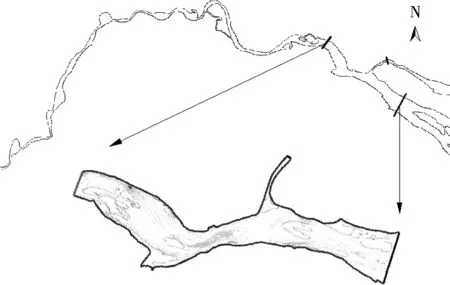
Fig.1 Map of the study area located in the Yangtze River Delta near the estuary
1.2 Target fish and target benthos
Coilia nasus is one of typical ecological fishes in the Yangtze River estuary[11]. Coilia nasus are divided into two categories. One migrates from the ocean to the estuary in certain seasons, and the other settles in inland lakes[12].The waterways, along the Yangtze River downstream from Nanjing to Nantong, are usually the best concentrated living place for the fishing season of Coilia nasus[13], which is chosen as the target fish.
Corbicula fluminea, also named the Asian clam, has an intensive distribution in the Yangtze River Delta[14]. Benthonic mollusks are the indicators of the aquatic environment. Corbicula fluminea have the ability to accumulate heavy metals and toxic substances, and can be found in sandy and muddy bottomed streams, rivers, ponds, lakes, and man-made canals[15]. Feeding on benthic algae, plankton and organic debris, Corbicula fluminea are omnivorous. Thus, Corbicula fluminea play an important role in ecological balance and are chosen as the target benthos.
2Model Description
2.1 Hydrodynamic model
Hydraulic conditions, such as water surface elevations and vertically averaged velocities, are computed by the fully nonlinear two-dimensional, depth-integrated option of the ADCIRC model[16]. The ADCIRC model has had many successful applications in coastal and estuary numerical modeling[17].
The governing equations are described in space using the linear finite element method and in time using the finite difference method. The basic governing continuity equation of the model is
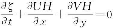
(1)
and the momentum equations of the model are
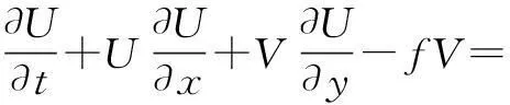
(2)
(3)
wheretis the time;x,yare the horizontal coordinates;ζis the free surface elevation;Uis the depth-averaged horizontal velocity;Vis the depth-averaged horizontal velocity;His the total water column depth,h+ζ;his the bathymetric depth;fis the Coriolis parameter;gis the acceleration due to gravity;ηis the Newtonian equilibrium tide potential;αis the earth elasticity factor;ρ0is the reference density of water;psis the atmospheric pressure at the free surface;τ*is the bottom stress;τsX,τsYare the applied free surface stress;MX,MYare the depth-integrated momentum dispersion.
2.2 Habitat suitability model
Generally, the habitat suitability model setup consists of five stages: 1) Obtain habitat data; 2) Setup the SI curve; 3) Give a weight to SI; 4) Choose a HSI calculation method and obtain the composite HSI score; 5) Scatterplot HSI[18]. It is assumed that the species and population directly choose a suitable habitat, meanwhile there is a linear relationship between the environment variables (food, water and abiotic factors) and the population[19].
The minimum model (MINM) and geometric mean model (GMM) are the basic methods of HSI[20]. Depending on the minimum of various SI, the MINM is applied to the establishment and evaluation of fishery reserves, and the ecological system maintenance and management[21-22]. The GMM is one of the HSI model mostly applied to resource estimation and fishery analysis[23-24]. The GMM is not affected by the extreme of SI with various SI at the same level.
H=min(S1,S2,…,Sn)
(4)
(5)
2.2.1Coilia nasus suitability
Variables which affect growth, survival, abundance, and other measures of Coilia nasus well-being, are considered in the creation of this model. Four aquatic ecological factors, which influence the habitat quality of Coilia nasus juveniles, are selected for the modeling as follows: 1) Water level amplitude for juvenilesV1; 2) Flow velocity for juvenilesV2; 3) Water temperature for adults and juvenilesV3; 4) Dissolved oxygen for juvenilesV4.
The suitable ranges and suitability index (SI) curves of the four main ecological factors are proposed based on the previous research. As shown in Fig.2, the suitability index curves for the habitat of Coilia nasus are established. A GMM is developed by analyzing a combination of these ecological factors. This model can be used to evaluate the habitat changes caused by deep-water channel regulation works.
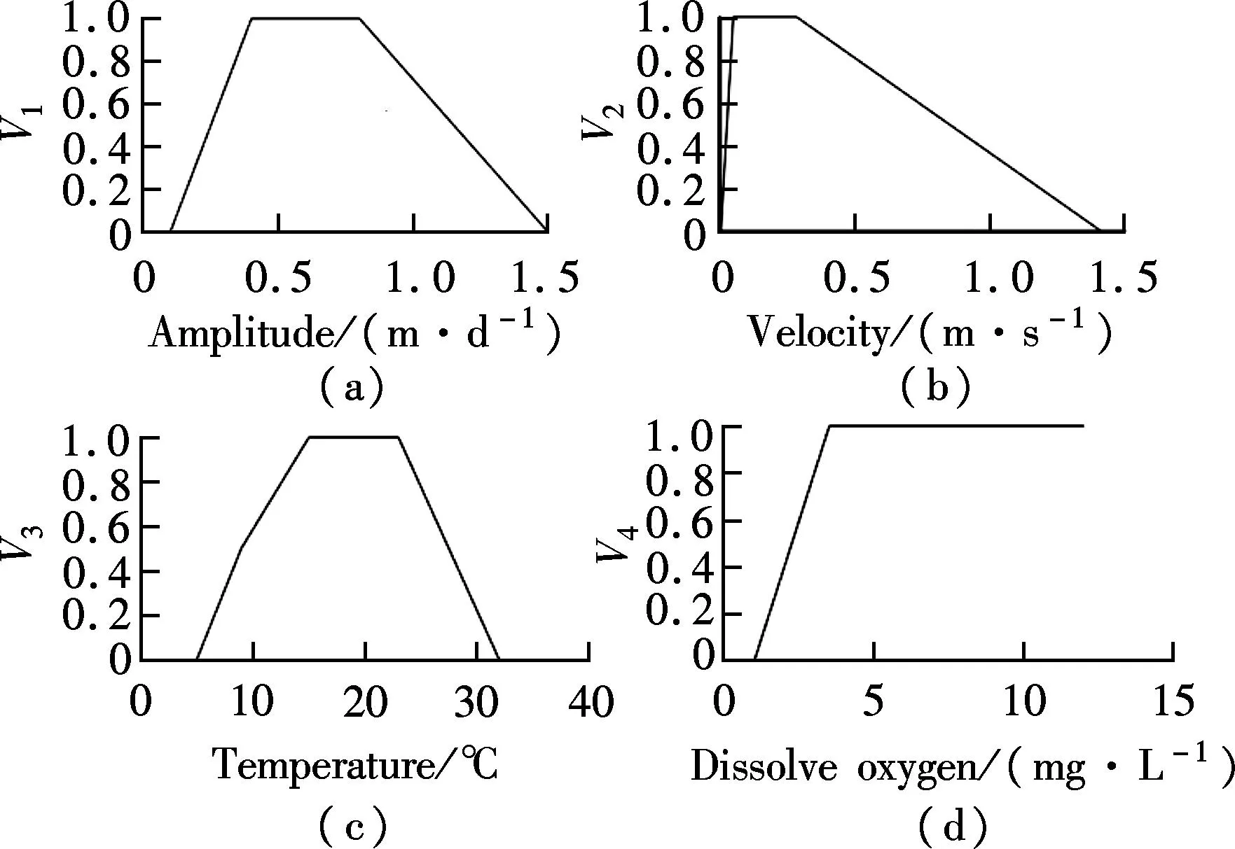
Fig.2 Suitability index curves for habitat of Coilia nasus. (a) Water level amplitude; (b) Velocity; (c) Temperature; (d) Dissolved oxygen
The HSI is defined for each grid in the simulation season. The habitat suitability index is
HSI=(V1V2V3V4)1/4
(6)
whereV1toV4are the SIs. The SI curve quantifies physical habitat, such as water temperature and flow velocity. The habitat suitability ranges from unsuitable (0) to optimal habitat suitability (1). The intermediate values represent the suitability range based on a specified hydraulic variable.
2.2.2Corbicula fluminea suitability
Corbicula fluminea live in the rivers and lakes with sand and mud substrate. We find its distribution density at the joining point between the river and ocean. Five aquatic ecological factors are selected for the modeling as follows: 1) Water temperature (V1); 2) Water depth (V2); 3) Flow velocity (V3); 4) Substrate types (V4); 4) Substrate depth (V5).
The components of this model are determined by the geometric mean of variables regardless of the values of the other habitat variables. The habitat suitability of flow conditionSFCis determined by the geometric mean variables (V1,V2,V3); while the habitat suitability of substrate conditionSSCis determined by the geometric mean variables (V4,V5).
Suitability index curves established for the habitat of Corbicula fluminea are shown in Fig.3. A MINM was developed by analyzing the combination of these ecological factors. The HSI is defined for each grid in the simulation season. The habitat suitability index is
HSI=min(SFC,SSC)
(7)
and
SFC=(V1V2V3)1/3
(8)
SSC=(V4V5)1/2
(9)
The intermediate values represent the suitability range based on a specified hydraulic variable.
3Model Setup and Verification
3.1 Model setup
The model domain is shown in Fig.3, which covers

Fig.3 Suitability index curves for habitat of Corbicula fluminea. (a) Temperature; (b) Water depth; (c) Velocity; (d) Subtrate; (e) Subtrate depth fluminea
the Yangtze River next to the estuary from Tiansheng Port to Dangqianzha. Three types of boundaries, namely, the inlet, outlet and solid walls are considered in the hydrodynamic model. The same unstructured finite-element mesh and bathymetry of this studied domain are developed for water depth and vertically averaged velocities. Meanwhile, habitat suitability index models calculating the final HSI score are programed, and the models are integrated with flow velocity and water depth.
3.2 Hydrodynamic model verification
To assess the modeling accuracy, the numerical model system is initially applied to simulate the hydrodynamic conditions. The stations for model verification are shown in Fig.4.
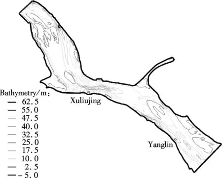
Fig.4 Stations used for verification
The hydrodynamic model is verified by comparing the observed tide level and velocity with the model simulation results in February 1998. As shown in Fig.5 and Fig.6, the tide levels of Xuliujing and the velocity of Yanglin stations match well with the observed datasets. The verified hydrodynamic model can be used in the following sections.
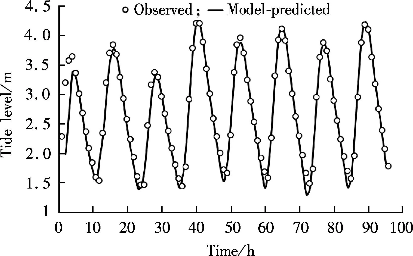
Fig.5 Comparison between model-predicted and observed tide levels of Xuliujing station
3.3 Habitat suitability index model verification
The velocities and water depth were simulated during
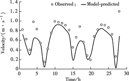
Fig.6 Comparison between the model-predicted and observed velocity of Yanglin station
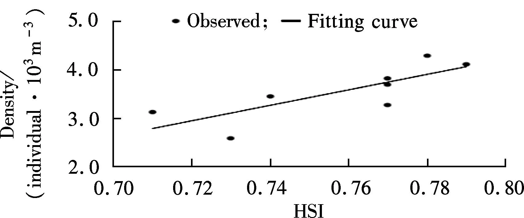
the 27th and 28th July, 2013 using the ADCIRC hydrodynamic model. Observed datasets include water temperature, dissolved oxygen, the density of the target species, etc. With simulated hydrodynamic conditions and observed datasets, the HSI score was calculated using the habitat suitability model. Simulated HSI and the observed density of Coilia nasus anchovy were fitted. The same method was taken to verify the Corbicula fluminea HSI model during the 10th and 11th November, 2012. As shown in Fig.7, the model simulation results of the two target species both have a good correspondence with the observed datasets. The association coefficient of the two datasets are 0.787 and 0.665, respectively, which proves that the HSI models calculated according to the above mentioned SI curves are practical.
(a)
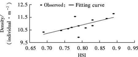
(b)Fig.7 Fitting between model-predicted HSI and observed density. (a) Coilia nasus; (b) Corbicula fluminea
4Effect of Regulation Project on HSI
4.1 Hydrodynamic conditions change
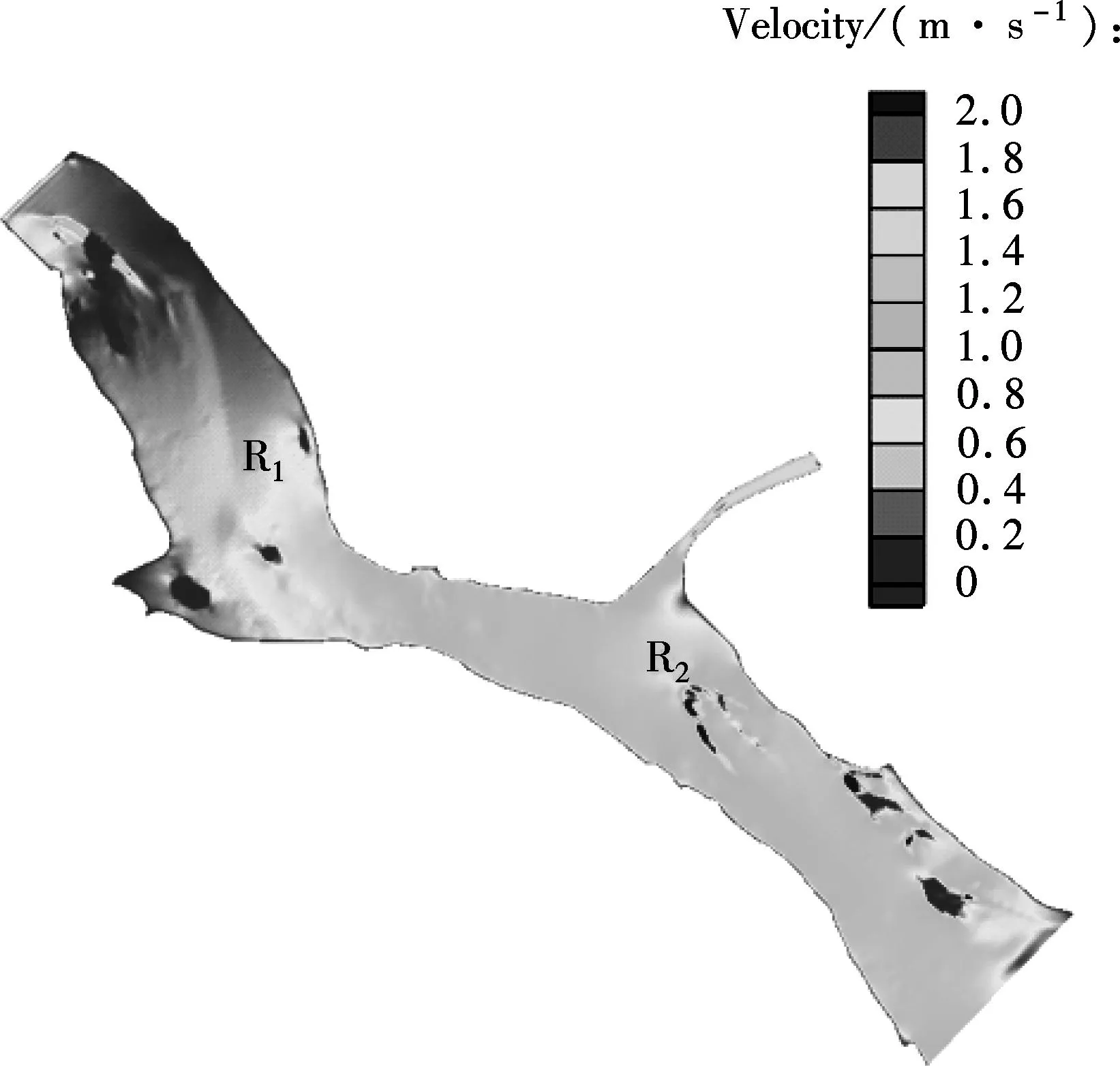
After a series verifications, the model can be applied to simulate the hydrodynamic conditions of the study area. The flow fields of pre- and post- regulation at ebb tide were simulated. The flow fields visualized are shown in Fig.8. Velocity changes occur around the spur dike and submerged dike. Particularly, in the R2area, regulation works influence the velocity field significantly, and decrease the velocity by as much as 2.0 m/s. In the R1area, the velocity changes range from 0 to 0.5 m/s. Meanwhile, the bodies of the spur dike and submerged dike decrease the water depth, and the bottom of the regulation works are covered by concrete structures. Other areas show little change. As an important ecological factor, the changes of the flow velocity can definitely affect the final HSI score.
(a)
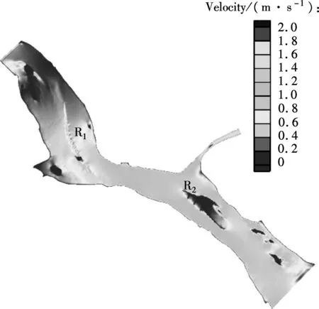
(b)Fig.8 Velocity at ebb tide from the hydrodynamic model in the study area. (a) Pre-regulation; (b) Post-regulation
4.2 Coilia nasus habitat evaluation
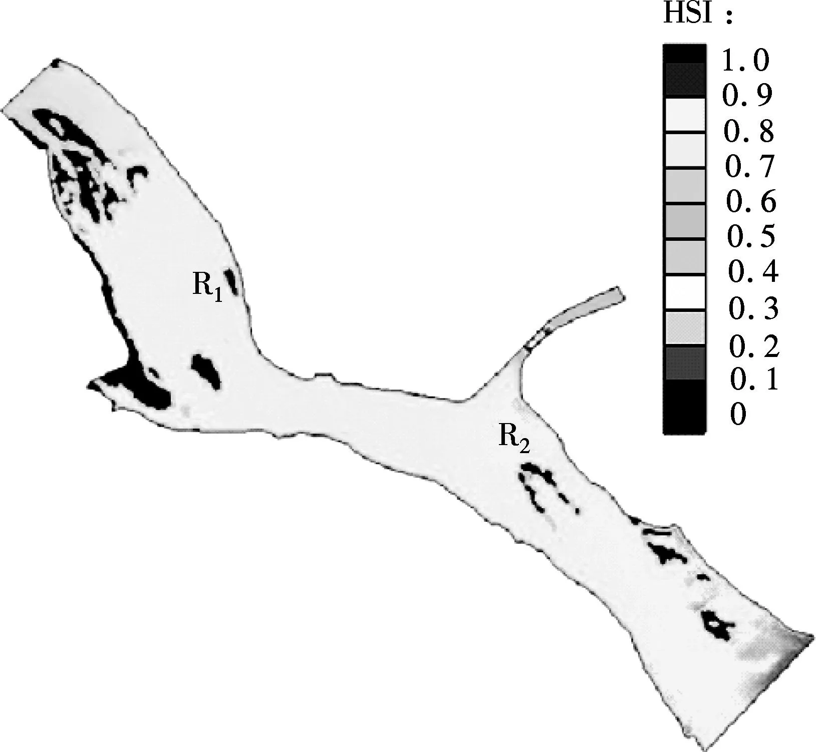
The value of HSI can be calculated for pre- and post-regulation conditions of the 12.5 m deep-water channel. The visualization of the model clearly indicates the changes in the study area before and after channel regulation. As shown in Fig.9, most regions have a high HSI value approaching 0.8 to 0.9, while shallow regions and left bank upstream have a relatively low HSI value approaching 0. There is little change in the Coilia nasus HSI value from the pre-regulation to post-regulation period in most areas, while results differ around spur dike and submerged breakwater. The suitability decreases in the regulation areas of both R1and R2, where velocity suitability and water level amplitude suitability decreases with bottom shoaling. There is a small area behind the spur dike where the HSI score increases, mainly due to the decrease in the flow velocity.
(a)
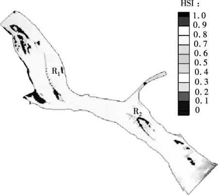
(b)Fig.9 HSIs of Coilia nasus from the coupled model in the study area. (a) Pre-regulation; (b) Post-regulation
4.3 Corbicula fluminea habitat evaluation
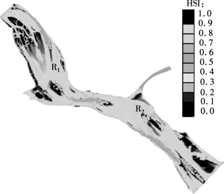
Corbicula fluminea’s results from the model evaluation are different from Coilia nasus. As shown in Fig.10, the HSI score of most regions approaches 0.9, and some shoal areas have a maximum value approaching 1.0. The mainly affected regions remain the regulation areas. There is an obvious increase of HSI score in the R1area.
5Conclusion
This paper builds a hydrodynamic and habitat suitability model to evaluate the habitat for the target species
(a)

(b)Fig.10 HSIs of Corbicula fluminea from the coupled model in the study area. (a) Pre-regulation; (b) Post-regulation
following deep-water channel regulations in the Yangtze River. Both two models are verified by observed datasets. Suitability index curves for the habitat of Coilia nasus and Corbicula fluminea are summarized and applied in the HSI models. With the coupled eco-hydrodynamic model, the comparison analysis of the habitat changes from the pre-regulation to post-regulation period indicates an improvement in potential habitat availability behind the spur dike for the two species studied.
The use of habitat suitability models to predict changes in river networks following disturbances or restoration efforts is a fast and effective method in river systems. The models allow researchers to forecast hydrodynamic and ecological impacts caused by different engineering activities in a river system, which can prove the accuracy of regulation plans and provide pertinent suggestions for ecosystem protection. Advancements in coupling of HSI models with the ADCIRC hydrodynamic model offer a novel prediction tool for the transverse distribution of habitats. This model can be applied to more similar engineering cases in the Yangtze River.
References
[1]Takayuki N, Yoshiki S, Kouki O, et al. Evaluation of suitable hydraulic conditions for spawning of ayu with horizontal 2D numerical simulation and PHABSIM[J].EcologicalModelling, 2008, 215(1): 133-143.
[2]Pringle C M. Hydrologic connectivity and the management of biological reserves: a global perspective[J].EcologicalApplications, 2001, 11(4): 981-998.
[3]Xiao D X. Introduction of 12.5 m deep-water channel construction project and its first phase of the Yangtze River below Nanjing city[J].Port&WaterwayEngineering, 2012, 11: 1-4. (in Chinese)
[4]USFWS (US Fish and Wildlife Service). Habitat as a basis for environmental assessment[R]. Washington, DC: USFWS, 1980.
[5]Morrison M L, Marcot B G, Mannan R W.Wildlife-habitatrelationships:conceptsandapplications[M]. Madison: University of Wisconsin Press, 1998.
[6]Kliskey A D, Lofroth E C, Thompson W A, et al. Simulating and evaluating alternative resource-use strategies using GIS-based habitat suitability indices[J].Landscape&UrbanPlanning, 1999, 45(99): 163-175.
[7]Yi Y J, Wang Z Y, Yang Z F. Two-dimensional habitat modeling of Chinese sturgeon spawning sites[J].EcologicalModelling, 2010(5): 864-875.
[8]Tomsic C A, Granata T C, Murphy R P, et al. Using a coupled eco-hydrodynamic model to predict habitat for target species following dam removal[J].EcologicalEngineering, 2007, 30(3): 215-230.
[9]Li R N, Chen Q W, Chen D. Ecological hydrograph based on Schizothorax chongi habitat conservation in the dewatered river channel between Jinping cascaded dams[J].ScienceChinaTechnologicalSciences, 2011, 54(Sup): 54-63.
[10]Chen X H. Research of hydrobiology in the Yangtze River in Jiangsu Province [D]. Nanjing: Fisheries College of Nanjing Agriculture University, 2007. (in Chinese)
[11]Jiang T, Yang J, Liu H B, et al. A comparative study of the morphology of sagittal otolith in Coilia nasus, Coilia mystus and Coilia nasus taihuensis[J].MarineSciences, 2011, 35(3): 23-31. (in Chinese)
[12]Yuan C M, Qin A L. Ecological habits and distribution of coilia along the chinese coast and its changes of output[J].MarineSciences, 1984, 8: 35-37. (in Chinese)
[13]Huang R S. Coilia nasus biological characteristics and the present situation of resources and protection countermeasures[J].ReservoirFisheries, 2005, 25(2): 33-33. (in Chinese)
[14]Zhang H C, Chen Y, Fan H F, et al. Climatic background of modern Cobicula fluminea and the stable isotopes of shells from the representative areas in continental China[J].MarineGeology&QuaternaryGeology, 2007, 32(1): 87-94. (in Chinese)
[15]Liu M, Xiong B X. Ecological characteristics of corbicula fluminea and its effect on the heavy metals accumulation[J].JournalofAnhuiAgriculturalSciences, 2008, 36(1): 221-224. (in Chinese)
[16]Luettich R A, Westerink J J. figuretion and numerical implementation of the 2D/3D ADCIRC finite element model version 44. XX [EB/OL]. (2004-08-12) [2015-10-27].http://www.unc.edu/ims/adcirc/publications/2004/2004_Luettich.pdf.
[17]Xu S D, Huang W R. Integrated hydrodynamic modeling and frequency analysis for predicting 1% storm surge[J].JournalofCoastalResearch, 2008(52): 253-260.
[18]Jin L R, Sun K P. Research advances in habitat suitability index model[J].ChineseJournalofEcology, 2008, 27(5): 841-846. (in Chinese)
[19]Van Horne B. Density as a misleading indicator of habitat quality[J].WildlifeManage, 1983(4): 893-901.
[20]Chen X, Tian S, Chen Y, et al. A modeling approach to identify optimal habitat and suitable fishing grounds for neon flying squid (Ommostrephes bartramii) in the Northwest Pacific Ocean[J].FisheryBulletin, 2010, 108(1): 1-14.
[21]Yi Y J, Wang Z Y, Yao S M. Habitat suitability model for evaluating Chinese sturgeon spawning sites[J].JournalofTsinghuaUniversity(ScienceandTechnology), 2008, 48(3): 340-343. (in Chinese)
[22]Y Y J, Wang Z Y, Lu Y J. Habitat suitability index model for Chinese Sturgeon in the Yangtze River[J].AdvancesinWaterScience, 2007, 18(4): 538-543. (in Chinese)
[23]Tian S Q, Chen X J, Chen Y, et al. Evaluating habitat suitability indices derived from CPUE and fishing effort data for Ommatrephes bratramii in the northwestern Pacific Ocean[J].FisheriesResearch, 2009, 95(2): 181-188.
[24]Tomsic C, Granata T, Murphy R, et al. Using a coupled eco-hydrodynamic model to predict habitat for target species following dam removal[J].EcologicalEngineering, 2007, 30(3): 215-230.
doi:10.3969/j.issn.1003-7985.2015.04.022
杂志排行

Journal of Southeast University(English Edition)的其它文章
- Mitigation of inter-cell interference in visible light communication
- Modified particle swarm optimization-based antenna tiltangle adjusting scheme for LTE coverage optimization
- Distribution algorithm of entangled particles for wireless quantum communication mesh networks
- Kernel principal component analysis networkfor image classification
- CFD simulation of ammonia-based CO2 absorption in a spray column
- Simulation and performance analysis of organic Rankine cycle combined heat and power system