柴达木盆地西台吉乃尔盐湖区域晚更新世环境变化
2015-03-01曾方明
曾方明,张 萍
(1.中国科学院青海盐湖研究所,西宁 810008;2.中国地质大学图书馆,武汉 430074)
doi:10.7515/JEE201504001
柴达木盆地西台吉乃尔盐湖区域晚更新世环境变化
曾方明1,张 萍2
(1.中国科学院青海盐湖研究所,西宁 810008;2.中国地质大学图书馆,武汉 430074)
本文对柴达木盆地西台吉乃尔盐湖剖面沉积物(XT剖面,240cm厚)的粒度、磁化率、色度和总有机碳(TOC)等指标记录的晚更新世环境变化进行了研究。结果表明:(1)XT剖面沉积物的粒度总体较细(中值粒径变化范围为3.4~10.0μm),但是25~47cm深和185~199cm深的粒度明显变粗(中值粒径变化范围为15.7~59.0μm)。(2)XT剖面沉积物的中值粒径与低频磁化率(χlf)呈正相关关系;红度(a*)与低频磁化率呈负相关关系。(3)XT剖面低频磁化率与全球深海δ18O记录试探性的对比表明西台吉乃尔盐湖区域晚更新世的气候变化可能受全球气候影响。
环境变化;更新世;柴达木盆地;西台吉乃尔盐湖
As a production of extremely arid climate with high ratio of evaporation to precipitation,salt lake sediments record paleoenvironmental information.Methods of stratigraphy,sedimentology,geochemistry and micropaleontology have been applied to reconstruct the past environment change that is recorded in salt lake deposits(Cai et al,2012;Wang et al,2013;Fan et al,2014;Han et al,2014;Wei et al,2015).
Salt lakes are widely distributed in the Qaidam Basin,northeastern Qinghai-Tibetan Plateau(QTP).Since the 1980s,evolution of salt lakes and its paleoenvironmental implications in the Qaidam Basin were researched on drilling cores from Qarhan salt plain(Chen and Bowler,1985;Huang and Chen,1990).The evolution of salt lake in the Qaidam Basin has been significantly impacted by global climate change during the past 730 ka(Huang and Chen,1990).Recently,a series of drill cores from Chaka salt lake(Liu et al,2008),Dalangtan playa(Hou et al,2010),Chahansilatu playa(SG-1)(Zhang et al,2012),Qarhan salt lake(ISL1A)(Fan et al,2014),and Gahai Lake(DG-02)(He et al,2014)in the Qaidam Basin have been studied on past environmental changes.
Compared to the above salt lakes and playas in the Qaidam Basin,study of the past environmental change in the Xitaijinair salt lake is scarce.Sediment of the XT section(240 cm depth)in the Xitaijinair salt lake region formed in the Pleistocene based on the OSL(optically stimulated luminescence)ages and AMS(accelerator mass spectrometry)14C ages(Zeng and Xiang,2015).This study aims to investigate the environmental change during the Pleistocene in the Xitaijinair salt lake region based on grain size,magnetic susceptibility,color reflectance,and total organic carbon proxies.
1 Samples and methods
1.1 Samples
Xitaijinair salt lake is located in the western Qaidam Basin.The lake basin is a closed basin.Sands,silts,clay,and salts deposited during the late Pleistocene in the Xitaijinair region.
XT section(37°40'42.69"N,93°32'47.73"E,2692 m above sea level),in Xitaijinair salt lake region,is outcropped by an excavator from surface downward to a 240 cm depth(Fig.1).The lithology of the XT section from the top to the bottom is as follows:0~25 cm,red silt and clayey silt;25~47 cm,green sandy silt;47~185 cm,red silt and clayey silt;185~199 cm,green sandy silt interbedded with red silt;199~240 cm,red silt(Zeng and Xiang,2015).Bulk samples for proxy analysis were collected at 2 cm intervals.

Fig.1 Location of the Xitaijinair section(XT section)in the western Qaidam Basin(after Zeng and Xiang,2015)
1.2 Methods
OSL dating for two samples was performed on an automated Risø TL/OSL DA-20 reader by method of Single Aliquot Regeneration(SAR)(Murray and Wintle,2000).The quartz grain size for OSL dating is 90~125 μm fractions.U,Th and K concentrations were measured by neutron activation analysis(NAA).Two OSL ages of 57.9 ± 5.7 ka(at the depth of 40 cm)and 69.1 ± 6.0 ka(at the depth of 190 cm)were obtained(Zeng and Xiang,2015).AMS14C dating for bulk organic matter of nine samples ranging between 33—40 cal ka BP were analyzed in the Center for Applied Isotope Studies at the University of Georgia,USA(Zeng and Xiang,2015).
Grain size analysis was tested by Beckman Coulter LS 13 320 laser diffraction grain size analyzerat School of Earth and Space Sciences,University of Science and Technology of China(USTC),China.Sample about 0.1~0.2 g was pretreated by 10 mL 30% H2O2to remove organic matter and 10 mL 10% HCl to remove carbonates.The relative error of the repeated measurement is less than 5%.
Magnetic susceptibility(MS)was measured by a Bartington MS2 magnetic susceptibility meter at USTC.Low-frequency MS(χlf)and high-frequency MS(χhf)values of air-dried samples were measured at 470 Hz and 4700 Hz,respectively.Frequencydependent susceptibility(χfd)is calculated by equation χfd=( χlf-χhf)/χlf×100.
Color reflectance was measured by a Konica Minolta CM-2500c spectrophotometer after the sample was ground carefully to powder at the Key Laboratory of Qinghai-Tibetan Plateau Environment and Resource,Qinghai Normal University,China.
Total organic carbon(TOC)content was determined by rapid dichromate oxidation method(Walkley and Black,1934).The procedure for determination of TOC content is as follows:(1)0.2000 g sample(ground to less than 75 μm by agate mortar)was weighed into a 50 mL glass tube;(2)5 mL 0.8000 mol·L-11/6 K2Cr2O7solution,0.1 g Ag2SO4,and 5 mL concentrated H2SO4were added;(3)When the temperature of oil bath was heated to 185℃,the glass tube was put into the oil bath and kept boiling at 170~180℃ for 5 minutes;(4)All materials were washed by deionized water to a 250 mL triangle bottle,and the volume of the solution was 60~80 mL;(5)5 mL phosphate and four drops 1% diphenylamine sulfonate(as indicator)were added to flask;(6)0.2 mol·L-1(NH4)2Fe(SO4)2was used for redox titration.TOC content of the salt lake sediment in the XT section was calculated by following empirical formula:TOC(%)=1.236 ×(V0-V )/(V0× m).
Where V0is the volume(mL)of 0.2 mol·L-1(NH4)2Fe(SO4)2used for titration of 5 mL 0.8000 mol·L-11/6 K2Cr2O7in control group;V is the volume(mL)of 0.2 mol·L-1(NH4)2Fe(SO4)2used for titration of excess 0.8000 mol·L-11/6 K2Cr2O7in the sample;m is mass of the sample(g).
The standard sample GSS-7(TOC value is 0.64% ± 0.07%)was used in the experiment.The relative error of the TOC content is less than 5%.
2 Results and discussion
2.1 Environmental change indicated by proxies in the Xitaijinair region
The median grain size(Md),<2 μm content(%),low-frequency magnetic susceptibility(χlf),highfrequency magnetic susceptibility(χhf),frequencydependent magnetic susceptibility(χfd),lightness(L*),redness(a*),yellowness(b*),and TOC content of the sediments in the XT section are presented in Fig.2.
Grain size is a common index for indicating the energy of the wind and water dynamics that transport particles from source area to depositional zone(Yang and Ding,2008;An et al,2012;Hao et al,2012).Median grain size is the medium value of the particle size distribution.The median grain size is remarkably higher at the depth of 25~47 cm and 185~199 cm(median grain size varying from 15.7 μm to 59.0 μm)than other part(median grain size ranging from 3.4 μm to 10.0 μm)in the XT section(Fig.2a),showing the strong energy for transporting particles.Meanwhile,the <2 μm content(%)proxy shows that the lowest value occurred at the depth of 25~47 cm and 185~199 cm(Fig.2b).
For lake sediments in Qinghai Lake,increased coarse grain size(>63 μm content)indicates strong large volume of river water flowed into Qinghai Lake,in response to high precipitation in the catchment over the last 800 years(Zhang et al,2003).However,increased coarse fraction(>25 μm)of Qinghai Lake sediments indicates dry condition resulted from intensified Westerlies in this region during the past 32 ka(An et al,2012).The above studies show that the controlling factors of coarse grains of sediments in the Qinghai Lake are complicated.The climate in the Qaidam Basin is affected by the Westerlies and probably heavy rainfall during the past.Due to the complicated controlling factors of coarse grains in the Xitaijinair salt lake,the climatic event indicated by coarse grain size in the XT section requires further study.

Fig.2 Proxies of the sediments in the XT section(the shaded boxes show the coarse sediments)
Magnetic susceptibility is a proxy of precipitation and East Asian summer monsoon strength on the Chinese Loess Plateau(An et al,1991;Song et al,2014).Magnetic susceptibility was also applied to reconstruct the past climate change recorded in lake deposits(Chen et al,1999;Yu and Kelts,2002).Similar to the grain size,obviously high χlfand χhfvalues occurred at the depth of 25~47 cm and 185~199 cm in the XT section(Fig.2c and 2d).The variations of χlfand χhfare very similar,with positive linear correlation coefficient R2of 0.99.χfdis sensitive to ultra-fine magnetic grains at the superparamagnetic(SP)-stable single domain(SSD)boundary(Song et al,2014).The χfdvalues vary from 0.14% to 4.66%(Fig.2e).χfdvalues fluctuate more frequently than χlfand χhfvalues in the sediments of the XT section.
Color ref ectance(Commission Internationale de l′Eclairage,CIE,L*,a*,b*)of the sediments ref ects the sedimentary environment and paleoclimatic condition(Ji et al,2005).Investigations show that the lightness(L*)of the sediment is related to TOC content,redness(a*)is related to hematite content,and yellowness(b*)is influenced by content of goethite and pyrite minerals(Sun et al,2011).L* values vary from 53.02 to 68.24(Fig.2f),a* values range from 4.55 to 11.50(Fig.2g),and b* values change from 15.96 to 22.45(Fig.2h)for the sediments in the XT section.The correlation between L* and TOC of the sediments in the XT section demonstrated that the higher TOC content,the lower value of L*(Fig.3a),in agreement with the previous study(Sun et al,2011).
TOC content of the sediments in the XT section is very low,varying from 0.14% to 0.82%(Fig.2i).It is interesting that the TOC content is positively correlated with yellowness b*(R2is 0.21)(Fig.3b).For the sediments in the XT section,the median grain size is positively correlated with χlfwith correlation coefficient R2of 0.67(Fig.3c).It may indicate that coarse sediments containing more magnetite and/ or maghemite with higher magnetic susceptibility values are transported to the Xitaijinari lake basin,while the f ne sediments in the XT section may have more hematite with lower susceptibility values.The above speculation is confirmed by negatively correlation(R2is 0.76)between redness a* and the χlf(Fig.3d).
All proxies indicate extremely climatic events probably occur at the depth of 25~47 cm and 185~199 cm in the XT section.However,the process and reason of this extremely climatic event needs more lines of evidence in future.
2.2 Global climate forcing of the Pleistocene climate change in the Xitaijinair salt lake region
The paleoclimatic change recorded in core CK-6 of the Qarhan salt lake was comparable with globalclimatic change implicated by the deep sea sediments,and the climatic variation in the Qarhan area during the past 730 ka was controlled by the global climate change(Huang and Chen,1990).

Fig.3 Linear correlations between(a)TOC content and L*,(b)TOC content and b*,(c)χlfand median grain size,(d)χlfand redness a* of the sediments in the XT section.(R2:Pearson's correlation coeff cient of linear regression.P:a level(2-tailed)of signif cance.)
Recently,OSL ages of high lake terraces and shorelines indicate that the highest lake level during the late Quaternary occurred at 130—71 ka [marine isotope stage(MIS)5] in the northeastern QTP(Madsen et al,2008;Fan et al,2010;Rhode et al,2010;Madsen et al,2013;Lai et al,2014).Additionally,the OSL ages of the marine core sediments(Lz908 and BH2)from Bohai Sea indicate that the highest sea level occurred at MIS 5 since the late Quaternary(Yi et al,2013).Therefore,it is suggested that the late Quaternary climate change in the northeast QTP is in accord with the pattern of global climate(Lai et al,2014).
Nine AMS14C ages,ranging between 33 and 40 cal ka BP,are obviously younger than the two OSL ages in the XT section(57.9 ka and 69.1 ka).The14C ages of the XT section are probably underestimated(Zeng and Xiang,2015).The14C dating results of XT section support the conclusion that the14C ages larger than ~ 25 ka BP are severe underestimates,especially dates on samples from arid regions(Lai et al,2014).Therefore,the chronology of XT section cannot be established by14C ages.
The sketchy chronological framework of the XT section is between 55 ka and 73 ka on the basis of two OSL ages(Zeng and Xiang,2015).It is noted that the accuracy of the OSL ages of the XT section is still debated.Interestingly,the χlfvalues of sediments in the XT section and δ18O records from the global deep oceans(Lisiecki and Raymo,2005)are roughly compared(Fig.4).Similar to the high lake levels in the northeastern QTP and high sea level in north China occurred at MIS 5 were inf uenced by the global climate,this study indicates that the climate change in the Xitaijinair region during the late Pleistocene is also possibly forced by the global climate.This study supports the previous study showing that the global climate inf uenced the climate change in the Qaidam Basin during the past 730 ka(Huang and Chen,1990).
3 Conclusions
(1)Grain size,magnetic susceptibility,color reflectance indicate that the Pleistocene climate change in Xitaijinair salt lake region fluctuates frequently.
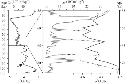
Fig.4 Comparisons with low-frequency magnetic susceptibility(χlf)of sediments in the XT section and δ18O records from the global deep oceans(Lisiecki and Raymo,2005)
(2)Low-frequency magnetic susceptibility(χlf)and the median grain size are positively linear correlated,but the χlfand redness(a*)are negatively linear correlated.
(3)Comparison with χlfrecords in the XT section and δ18O records in the global deep oceans indicates that the climate change in the Xitaijinair salt lake region is forced by global climate.Acknowledgements:Thanks are extended to Prof.SUN Li-guang and Dr.ZHOU Xin for help in laboratory work,to LI Bin-kai,YE Xiu-shen and ZHANG Guowei for their help in field work.Sincere thanks are extended to anonymous reviewer for a critical review and constructive comments.
黄 麒,陈克造.1990.七十三万年来柴达木盆地察尔汗盐湖古气候波动的形式[J].第四纪研究,10(3):205-212.[Huang Q,Chen K Z.1990.Palaeoclimatic fluctuation fashion of Qarhan salt lake in Qaidam Basin in the past 730000 years [J].Quaternary Sciences,10(3):205-212.]侯献华,郑绵平,张成君,等.2010.柴达木盆地西部大浪滩140 ka以来沉积特征与古环境[J].地质学报,84(11):1623-1630.[Hou X H,Zheng M P,Zhang C J,et al.2010.Sedimentary characteristics and paleoenvironmental of Dalangtan salt lake in western Qaidam basin,Since 140 ka BP [J].Acta Geologica Sinica,84(11):1623-1630.]
An Z S,Colman S M,Zhou W J,et al.2012.Interplay between the Westerlies and Asian monsoon recorded in Lake Qinghai sediments since 32 ka [J].Scientif c Reports,2:619.
An Z S,Kukla G J,Porter S C,et al.1991.Magnetic susceptibility evidence of monsoon variation on the Loess Plateau of Central China during the last 130,000 years [J].Quaternary Research,36(1):29-36.
Cai M,Fang X,Wu F,et al.2012.Pliocene-Pleistocene stepwise drying of Central Asia:evidence from paleomagnetism and sporopollen record of the deep borehole SG-3 in the western Qaidam Basin,NE Tibetan Plateau [J].Global and Planetary Change,94:72-81.
Chen F H,Shi Q,Wang J M.1999.Environmental changes documented by sedimentation of Lake Yiema in arid China since the Late Glaciation [J].Journal of Paleolimnology,22(2):159-169.
Chen K Z,Bowler J M.1985.Preliminary study on sedimentary characteristics and evolution of palaeoclimate of Qarhan Salt Lake in Qaidam Basin [J].Scientia Sinica(Series B),28(11):1218-1231.
Fan Q S,Lai Z P,Long H,et al.2010.OSL chronology for lacustrine sediments recording high stands of Gahai Lake in Qaidam Basin,northeastern Qinghai-Tibetan Plateau [J].Quaternary Geochronology,5(2-3):223-227.
Fan Q S,Ma H Z,Ma Z B,et al.2014.An assessment and comparison of230Th and AMS14C ages for lacustrine sediments from Qarhan Salt Lake area in arid western China [J].Environmental Earth Sciences,71(3):1227-1237.
Han W,Ma Z,Lai Z,et al.2014.Wind erosion on the northeastern Tibetan Plateau:constraints from OSL and U-Th dating of playa salt crust in the Qaidam Basin [J].Earth Surface Processes and Landforms,39(6):779-789.
Hao Q Z,Wang L,Oldf eld F,et al.2012.Delayed build-up of Arctic ice sheets during 400,000-year minima in insolation variability [J].Nature,490:393-396.
He Y,Zheng Y,Pan A,et al.2014.Biomarker-based reconstructions of Holocene lake-level changes at Lake Gahai on the northeastern Tibetan Plateau [J].The Holocene,24(4):405-412.
Ji J,Shen J,Balsam W,et al.2005.Asian monsoon oscillations in the northeastern Qinghai-Tibet Plateau since the late glacial as interpreted from visible reflectance of Qinghai Lake sediments [J].Earth and Planetary Science Letters,233(1-2):61-70.
Lai Z P,Mischke S,Madsen D.2014.Paleoenvironmental implications of new OSL dates on the formation of the "Shell Bar" in the Qaidam Basin,northeastern Qinghai-Tibetan Plateau [J].Journal of Paleolimnology,51(2):197-210.
Lisiecki L E,Raymo M E.2005.A Pliocene-Pleistocene stack of 57 globally distributed benthic δ18O records [J].Paleoceanography,20,PA1003,doi:10.1029/2004PA001071.Liu X Q,Dong H L,Rech J A,et al.2008.Evolution of Chaka Salt Lake in NW China in response to climatic change during the Latest Pleistocene—Holocene [J].Quaternary Science Reviews,27(7-8):867-879.
Madsen D B,Lai Z P,Sun Y J,et al.2013.Late Quaternary Qaidam lake histories and implications for an MIS 3 "Greatest Lakes" period in northwest China [J].Journal of Paleolimnology,51(2):161-177.
Madsen D B,Ma H Z,Rhode D,et al.2008.Age constraints on the late Quaternary evolution of Qinghai Lake,Tibetan Plateau [J].Quaternary Research,69(2):316-325.
Murray A S,Wintle A G.2000.Luminescence dating of quartz using an improved single-aliquot regenerative-dose protocol [J].Radiation Measurements,32(1):57-73.
Rhode D,Ma H Z,Madsen D B,et al.2010.Paleoenvironmental and archaeological investigations at Qinghai Lake,western China:Geomorphic and chronometric evidence of lake level history [J].Quaternary International,218(1-2):29-44.
Song Y,Hao Q Z,Ge J Y,et al.2014.Quantitative relationships between magnetic enhancement of modern soils and climatic variables over the Chinese Loess Plateau [J].Quaternary International,334-335:119-131.
Sun Y,He L,Liang L,An Z.2011.Changing color of Chinese loess:Geochemical constraint and paleoclimatic significance [J].Journal of Asian Earth Sciences,40(6):1131-1138.
Walkley A,Black I A.1934.An examination of the Degtjareff method for determining organic carbon in soils:Effect of variations in digestion conditions and of inorganic soil constituents [J].Soil Science,37(1):29-38.
Wang J,Fang X,Appel E,et al.2013.Magnetostratigraphic and radiometric constraints on salt formation in the Qaidam Basin,NE Tibetan Plateau [J].Quaternary Science Reviews,78:53-64.
Wei H,Fan Q,Zhao Y,et al.2015.A 94—10 ka pollen record of vegetation change in Qaidam Basin,northeastern Tibetan Plateau [J].Palaeogeography,Palaeoclimatology,Palaeoecology,431:43-52.
Yang S L,Ding Z L.2008.Advance-retreat history of the East-Asian summer monsoon rainfall belt over northern China during the last two glacial-interglacial cycles [J].Earth and Planetary Science Letters,274:499-510.
Yi L,Lai Z,Yu H,et al.2013.Chronologies of sedimentary changes in the south Bohai Sea,China:constraints from luminescence and radiocarbon dating [J].Boreas,42:267-284.
Yu J Q,Kelts K R.2002.Abrupt changes in climatic conditions across the late-glacial/Holocene transition on the NE Tibet-Qinghai Plateau:evidence from Lake Qinghai,China [J].Journal of Paleolimnology,28(2):195-206.
Zeng F M,Xiang S Y.2015.Geochronology and mineral composition of the Pleistocene sediments in Xitaijinair salt lake region,Qaidam Basin:preliminary results [J].Journal of Earth Science.Accepted.
Zhang J,Jin M,Chen F,et al.2003.High-resolution precipitation variations in the Northeast Tibetan Plateau over the last 800 years documented by sediment cores of Qinghai Lake [J].Chinese Science Bulletin,48(14):1451-1456.
Zhang W,Appel E,Fang X,et al.2012.Magnetostratigraphy of deep drilling core SG-1 in the western Qaidam Basin(NE Tibetan Plateau)and its tectonic implications [J].Quaternary Research,78(1):139-148.
Late Pleistocene environmental change in the Xitaijinair salt lake region,Qaidam Basin
ZENG Fang-ming1,ZHANG Ping2
(1.Qinghai Institute of Salt Lakes,Chinese Academy of Sciences,Xining 810008,China;
2.Library,China University of Geosciences,Wuhan 430074,China)
This study investigated late Pleistocene environmental change indicated by proxies(grain size,magnetic susceptibility,color ref ectance,and total organic carbon)of the 240 cm-deep XT section in the Xitaijinair salt lake region.The results suggest that:(1)Sediments in the XT section are generally f ne(median grain size ranging from 3.4 μm to 10.0 μm),but are coarse at the depth of 25~47 cm and 185~199 cm(median grain size varying from 15.7 μm to 59.0 μm).(2)Median grain size is positively correlated with low-frequency magnetic susceptibility(χlf).Redness a* is negatively correlated with χlf.(3)Tentative comparison with χlfrecords in the XT section and δ18O records in the global deep oceans shows that the Pleistocene climate change in the Xitaijinair salt lake region is possibly inf uenced by global climate.
environmental change;Pleistocene;Qaidam Basin;Xitaijinair salt lake
Zeng Fang-ming,E-mail:fmzeng@163.com
P534.631
A
1674-9901(2015)04-0201-07
Received Date: 2015-06-24
Foundation Item: Youth Guidance Foundation of ISL-CAS(Y460261051)