Modeling of sediment and heavy metal transport in Taihu Lake, China*
2013-06-01WANGChao王超SHENChao申超WANGPeifang王沛芳QIANJin钱进HOUJun侯俊
WANG Chao (王超), SHEN Chao (申超), WANG Pei-fang (王沛芳), QIAN Jin (钱进), HOU Jun (侯俊),
LIU Jia-jia (刘佳佳)
Key Laboratory of Integrated Regulation and Resource Department on Shallow Lakes, Ministry of Education and College of Enviroment, Hohai University, Nanjing 210098, China, E-mail: cwang@hhu.edu.cn
Modeling of sediment and heavy metal transport in Taihu Lake, China*
WANG Chao (王超), SHEN Chao (申超), WANG Pei-fang (王沛芳), QIAN Jin (钱进), HOU Jun (侯俊),
LIU Jia-jia (刘佳佳)
Key Laboratory of Integrated Regulation and Resource Department on Shallow Lakes, Ministry of Education and College of Enviroment, Hohai University, Nanjing 210098, China, E-mail: cwang@hhu.edu.cn
(Received July 7, 2012, Revised December 18, 2012)
With the current rapid economic growth, heavy metal pollution has become one of the key issues in the Taihu Lake. Although heavy metal pollution levels and distributions of the Taihu Lake have previously been described, an effective model to describe the transport process of heavy metals between the water column and sediment bed for this lake is not available. It is known that heavy metals in the water column can be related to the resuspension of sediment in the lake bed. In this study, we set up a coupled model of relating hydrodynamics, sediment and heavy metals based on Environmental Fluid Dynamics Code (EFDC), and applied it to Taihu Lake, China. For calibration and validation of the model, we employed two series of field sampling data taken all over Taihu Lake during April and July of 2009. The results show that the hydrodynamics simulations of the coupled model agree with the observations reasonably well and the sediment and heavy metal model shows similar variation trends during the simulation. Our results indicate that the model can be used for simulating the sediment and heavy metal transport process in the Taihu Lake and here we provide an effective tool for water quality management at small time scales.
sediment, heavy metal, Environmental Fluid Dynamics Code (EFDC), Taihu Lake
Introduction
The Taihu Lake, located in eastern China (see Fig.1), is the third largest freshwater lake in China. Its total water surface area is about 2 338 km2with the mean depth of 1.9 m. Because the Taihu Basin is the most developed area in China, the lake suffers a serious water pollution problem[1]. Eutrophication and algae bloom are the focal water environment problems in the Taihu Lake, which have been studied for years[2]. In recent years, heavy metal pollution has become one of the key fields of study for the Taihu Lake facing enhanced eutrophication. There are many studies with field sampling and assessments on the sediment and heavy metal pollution in the water column of the Taihu Lake[3-5].The authors reported heavy metal concentrations and performed superficial analyses on the different distributions of heavy metals in different regions. Therefore, the available data allows for developing a sediment-heavy metals model coupled to hydrodynamics to simulate the transport process of sediment and heavy metals in the water column and sediment bed. Such a model can help managing the water quality and predicting the trend of heavy metal contaminant levels during high-flow events as well as environmental accidents.
The study of sediment and heavy metals transfer models has been a hotspot issues in the world since the 1990s. Sager[6]modeled a mercury transport model in the water body of the Lavaca Bay, Bale[7]described a numerical model to study the fate of aquatic mercury in the Clear Lake, California. Weiss et al.[8]conducted a simple model that integrates heavy metal removal by aquatic plants and sediments in storm water detention ponds. Chu and Rediske[9]developed a cadmium and sediment transport model in a coupled stream-wetland system. All these studies have showed that the heavy metal transport process and the watercolumn have a close relationship with sediment resuspension and deposition.
In this study, a sediment-heavy metal trasnspot model for the Taihu Lake is established based on the Environment Fluid Dynamics Code (EFDC). The model is then calibrated and validated with data from two field samplings in April and July of 2009. Finally, our analyses shed light on the accuracy and performance of the presented models.
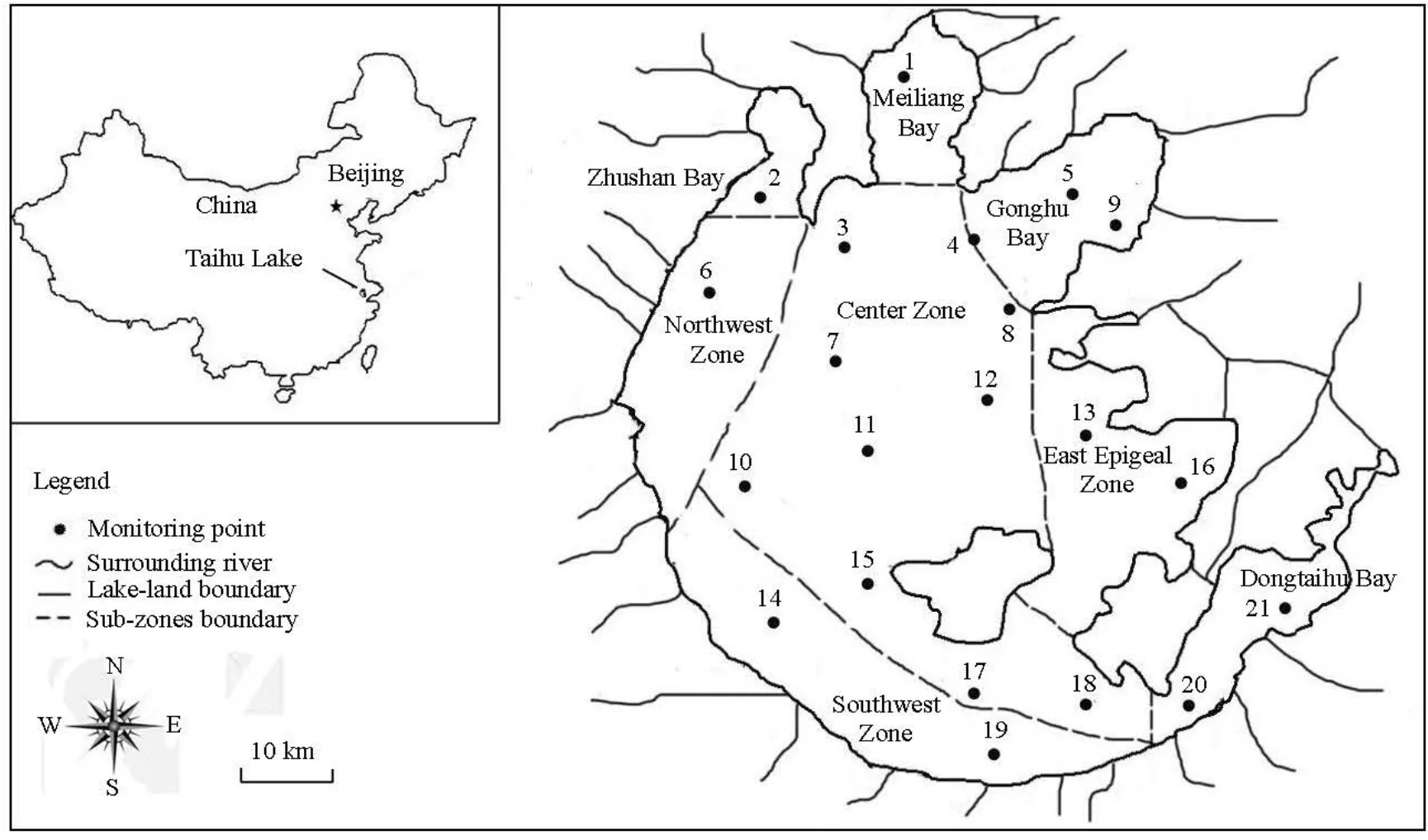
Fig.1 The location of Taihu Lake, surrounding rivers, and monitoring points
1. Study area
The Taihu Lake, the third largest fresh water lake in China, is located in the Yangtze River Delta in Eastern China. It lays an important role in people’s daily life and industrial production in the region. On the other hand, it is also a repository for waste water from urban centers and nearby agricultural and industrial segments with a rapidly growing local economy. The Taihu Lake can be divided into eight sub-zones as shown in Fig.1, named as the Zhushan Bay, Meiliang Bay, Gonghu Bay, Northwest Zone, Southwest Zone, Centre Zone, East Epigeal Zone, and Dongtaihu Bay, respectively[10], according to their hydrology, hydrodynamic and ecological characteristics.
2. Model description
The model developed in this study is based on the EFDC[11]. This model is used to solve the threedimensional turbulent averaged equations of motion for a variable density fluid under a vertically hydrostatic assumption. Dynamically coupled transport equations for turbulent kinetic energy, turbulent length scale, and temperature are also solved. The two turbulence transport equations implement the Mellor-Yamada level 2.5 turbulence closure scheme[12].
2.1 Hydrodynamics and wave models The following three equations describe the momentum conservation[11]:

where uandvare the horizontal velocity components in the orthogonal coordinatesx,yandwrepresents the vertical velocity,mxand myare the transformation factors in the horizontal coordinates, and m= mxmyis the Jacobian or square root of the metric tensor determinant. The total depth,H=h+ζ, is the sum of the water depth and the free surface displacement. The pressurePis the physical pressure in excess of the reference density hydrostatic pressure, ρ0gH (1-Z), divided by the reference density ρ0. The densityρ, is a function of temperature,T, and salinity,S, while bis the buoyancy which is defined in the equation as the normalized deviation of density from the reference value. In the momentum equations, f is the Coriolis parameter,Avis the vertical turbulent or eddy viscosity,Quand Qvare momentum source-sink terms.
The circulation patterns and suspended sediment concentrations of the Taihu Lake are impacted significantly by wind-induced currents and wind-wave action, respectively. A spectra wind-wave model, the Simulating Waves Nearshore (SWAN) model was used to calculate significant wave height, wave direction, and wave period in the lake. The computed bottom shear stresses were used to determine the sediment resuspension and deposition in the sediment modeling processes as well as lake currents. The numerical model of waves using the same grid of hydrodynamics model, was successfully applied, calibrated, and verified to Taihu Lake by Li et al.[13]. Details of governing equations, model setting process and parameters setting can be found in Ref.[13].
2.2 Sediment and heavy metals transport models
The sediment transport model is coupled with the hydrodynamic model with the same resolution, the transport equations are
in which H is water depth,Sis sediment concentration,u,v,ware velocities in the Cartesian coordinatesx,yandz , respectively,wsis settling velocity of sediment.Qsis external point and nonpoint sources,J0is net sediment flux (deposition flux and J0r+ resuspension flux J0d),AHstands for hori-zontal diffusivity determined by the Smagoringsky scheme[14],AVis the vertical eddy diffusivity estimated by the Mellor-Yamada level 2.5 turbulence closure scheme.
On the sediment bed, the net sediment flux is equal to the summation of sediment erosion flux and sediment deposition flux:
where τbis the stress exerted by the flow on the lake bed,d me/dtstand for the surface erosion rate per unit surface area of the bed,τceis the critical stress for surface erosion, andαis an empirical constant that is set to 1.05 in this study.
where τcdis a critical stress for deposition that depends on sediment material and physiochemical properties.
Contaminant transport equation can be described similarly as follows

where QCis the external point and nonpoint sources, and F0represents net flux of metal from the sediment bed to the water column.where the superscriptsw,b define the water column and sediment bed conditions at the water-sediment bed interface,ρsis the sediment density,ρwis the water density,εr,εdare the sediment bed surface void ratios under conditions of resuspension and deposition,fp,fdare defined as follows:

in which P is the equilibrium partition coefficient,θ is the porosity,CPis the particulate metal concentration,Cdis the dissolved metal concentration.
3. Sampling and determination of heavy-metal concentrations
The concentration of one heavy metal could be different from another in one or more orders of magnitude. In the report of Yuan et al.[15]about the sediment in the Taihu Lake, they found that the enrichment of Cr is more conspicuous than other metals. The potential heavy metal risk pollution of Cr caused by resuspension is the highest. On the other hand, the metal with highest concentration in the water column and sediment is Fe according to Zhu et al.’s study[16]. Therefore, Cr and Fe, two typical heavy metals at different levels were selected in this study. On April 11, and September 21, 2009, we carried out two field surveys all over the Taihu Lake with the monitoring points as shown in Fig.1. The data derived from these field surveys was taken to calibrate and validate the model. The developed model was set for short-time scale simulation and prediction, and the sampling point covered all over the Taihu Lake. Therefore, the two series of short-time monitoring data was representative enough to model calibration and validation.
The sampling methods were based on China’s national standard (Guidance on Sampling Techniques of Water Quality, GB12998-91). Total Suspended Solids (TSS) were determined with the gravimetric method based on the national standard GB 11901-89 (Determination of Suspended Substance-Gravimetric Method) of China. Inductively coupled plasma mass spectrometry (ICP-MS) was used to determine the concentrations of Cr and Fe in the water column.
4. Numerical simulation
4.1 Model set-up and solutions
Rectangular Cartesian grids were used to constructing the Taihu Lake flow model, with 4 250 active cells available in a uniform grid of 750 m in both xandydirections. A vertical sigma coordinate evenly distributing the 3-layer system was applied to a better simulation of thetopography. The numerical solutions of the EFDC model equations were obtained with a finite volume-finite difference spatial discretization with a marker-and-cell.
The simulation periods contained two parts, one for calibration and the other for validation of the models. The first simulation period for the model calibration study was from April 11 to May 11, 2009, and the second simulation for model validation from July, 11 to August, 11. Time step was set to be a constant of 60 s.
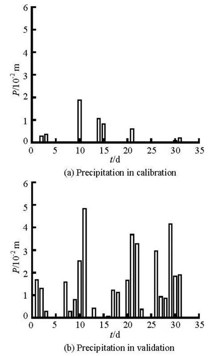
Fig.2 The precipitation in the calibration period (a) and the validation period (b)
4.2 Boundary and initial conditions
The boundary conditions include out-boundary conditions and in-boundary conditions. 30 main in / outflow surrounding rivers were taken into account as shown in Fig.1. The dominant wind directions near the lake in the spring and summer are northwesterly and southeasterly, with a mean velocity of 3.5 m/s-5 m/s[17]. The average lake current velocity under the wind filed changed in a small scale from 0.097 m/s to 0.108 m/s in preliminary numerical tests. So, the wind field of 4 m/s with east and southeast directions were employed in the calibration and validation periods, respectively. Precipitation data in the two simulation periods came from the Taihu Basin Authority(TBA)[18]as shown in Fig.2, and daily evaporation rate was set to be 2.25 mm/d.

Table 1 Initial concentrations of TSS, Cr and Fe in water column of eight sub-zones of Taihu Lake
In calibration period, the initial water level was set to be 3.35 m, the average of the whole lake on the first day of the calibration period. Similarly, the initial water level of 3.16 m was set in the validation. Initial velocities were set to zero in both of the two periods. Different initial TSSs and metals of every sub-zone in the water column were based on the TBA’s annual field observations. The heavy metals and TSS concentrations of in/out flows were set as the mean of the whole lake, and details are shown in Table 1. The partition coefficientsP of Cr and Fe in the water column were 0.1 l/mg and 1.0 l/mg suggested by the USEPA[19].
The lake bed contains two types of sediment: cohesive and non-cohesive ones. Field survey data showed that the sediment in the Taihu Lake was mainly recognized as cohesive one[20]. The filed survey data also showed that the sediment with median diameters of 0.000017 m was dominated. So we considered the sediment a uniform type with median diameters of 0.000017 m. The resuspension, deposition, water-sediment interface contaminants absorption/desorption happened mainly in the top sediment bed. So the setting of 5 centimeters as the active sediment layer thickness in the lake bed is rational. The density of the sediment was 1.3 kg/l, and the porosity was set to 0.725[19]. In our study, the concentrations of Cr and Fe were set to be medium values of 60 mg/kg and 18 000 mg/kg in the lakebed sediment. The partition coefficients of Cr and Fe in the sediment of lakebed were 0.2 l/mg and 0.1 l/mg, which were also suggested by the USEPA[19].
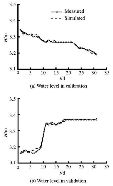
Fig.3 Time series of simulated and observed average water level of the whole lake for the calibration period (a) and validation periods (b)

Fig.4 The simulated current field (a) and observed current field (according to TBA’s field survey report) (b) of Taihu Lake in the wind field of 4 m/s, SE
5. Results and discussions
The parameters in the model included hydrodynamics parameters, sediment and contaminant transport parameters. All the parameters were adjusted constantly in the calibration simulations to meet the accuracy requirement. The validation was carried out to further verify the previous assumptions and selections of the parameters. In the two periods of simulation the water levels of the hydrodynamics model were calibrated and validated by the time-series water level data during the periods, and the current field by the previous study in the Taihu Lake. The sediment and heavy metal model was calibrated and validated by the data from two field samplings in April and July, 2009.
5.1 Hydrodynamics
The inner parameters properly affecting the lake currents and water levels were bottom roughness height and Smagnorinsky’s coefficient. Significant changes in roughness height and Smagnorinsky’s coefficient resulted in only small changes in the model results such as water level and velocity of lake currents. Constant bottom roughness height of 0.02 m and Smagnorinsky’s coefficient of 0.2 were considered appropriate after calibration and validation.
The water level simulations in calibration and validation period showed a perfect agreement with the realistic conditions as shown in Fig.3. In the calibration period, the precipitation was much lower than that in the validation period, so the water level curve showed a downward trend from 3.35 m to 3.19 m due to evaporation. The water level rose on the 11th day of the period with heavy rain. As a result, precipitation and evaporation were assumed dominant factors influencing the water level.
The lake current simulation was calibrated by the measured flow field under the southeast wind field of 4 m/s. The comparison between measurements and simulations is shown in Fig.4. The trends and magnitudes of velocity in the numerical model were generally in agreement with the measurements except for some small differences. There was a huge anticlockwise circular flow in the southwest lake, small circulations in the Meiliang Bay and Gonghu Bay were also shown in the simulation. The trends of the circular currents were affected mainly by the topography of the Taihu Lake and wind directions. Highest flow velocities occurred in the western lake, this phenomenon was mainly caused by the flat and smooth topography of the western lake.
5.2 Sediment and heavy metal transport
In general, the simulations agree well with the observations. From the monitoring poins t 1 to 21, the curves of monitoring point to TSS, Cr and Fe show similar trends. When the TSS concentration fluctuated, the Cr and Fe fluctuated in a similar manner. In the calibration period, the TSS, Cr and Fe concentrations in monitors 11 to 21 were higher than those in monitors 1 to 10. But in the validation period, the opposite trend occurred. One of the reasons for this phenomenon might be season difference between the calibration and validation periods. It can be found from Figs.5 and 6 that the spatial distributions of contaminant concentrations were inhomogeneous for both the calculated and observed data series. Also, the variation trends of TSS and heavy metals show consistencies to a large extent. These consistencies confirmed the close relationship between sediment and heavy metals in the water column. The variation trends of Cr showed higher consistency with TSS than that of Fe.
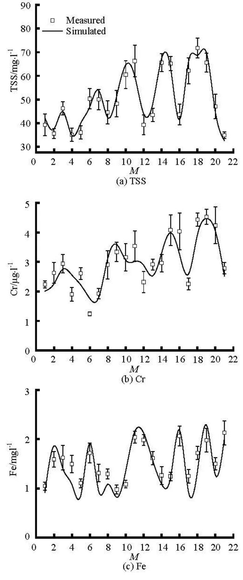
Fig.5 Comparison of simulated and measured sediment and heavy metals during the calibration period in April

Fig.6 Comparison of simulated and measured sediment and heavy metals during the validation period in July
This phenomenon indicates Cr is absorbed by sediments more than Fe. The preceding setting of the partition coefficient can confirm it. The distributions of heavy metals in the different regions show moderate differences. In the calibration period, the high values were mainly distributed in the southern littoral subzones of the Taihu Lake. The dominant northwesterly wind drove the wind-induced lake current to bring more contaminants to the southern part. In the validation, the southern part of the distribution reversed. Adequate rainfall made the surrounding river flows rise a great deal. More contaminants, such as sediment, nutrient and heavy metals, were brought in with the increased flows of the northern in-flow rivers. The dominant wind direction for validation was southeasterly, wind-induced current restricted the contaminant transport to the southern regions. These two factors made the contaminant levels of lake area near the inlets of the northern in-flow rivers were higher than other regions. Another phenomenon should be noted was that the Fe concentrations in validation were always lower than that of calibration. A possible reason was that the Fe was more easily absorbed by the sediment in water column because of its oxidability[21], which was reflected on the higher partition coefficient in the model. In validation, the amount of suspended sediment was discharged into the Taihu Lake, and Fe was absorbed by sediment. The adhered Fe settled with sediment with the sediment occupied a part of total Fe concentrations in water column and sediment bed. The key parameters in the models for hydrodynamics and sediment-metal transport are shown in Table 2.In general, the error analyses in Tables 3 and 4 show that the simulated TSS, Cr and Fe agree well with the observed data. In the calibration, compared to the 21 field monitoring data, the mean relative errors are 6.08% for TSS, 13.03% for Cr, and 14.74% for Fe. The relative RMSEs for TSS, Cr and Fe are 8.99%, 11.80% and 20.50%, respectively. In validation period, the errors between the simulated and observed data are larger than those in the calibration period. The mean relative errors are 7.32%, 13.50% and16.96% for TSS, Cr and Fe, respectively. Both in calibration and validation periods, the relative error for Fe is always larger than that for Cr. The partition coefficient difference between Fe and Cr indicates that Fe exists in particle phase more than Cr. The concentration of Fe in water column more closely depends on the process of sediment resuspension and deposition instead of convective diffusion between overlying water and pore water. The deviations of resuspension and deposition might amplify the errors in the computation of Fe concentration.

Table 2 Key parameters setting in the models for hydrodynamics and sediment-metal transport
Table 4 Error analysis of observed and modeled TSS, chromium (Cr), and iron (Fe) in validation
The developed model has simulated the sediment-heavy metal transport process in the water column of the Taihu Lake with acceptable accuracy, but there are two main disadvantages that increase the difficulty in these simulations. Firstly, the transport of sediment and heavy metals is a long-term process. The surveys and simulations were only referred two shortterm studies. Whether the model can simulate the long-term sediment and heavy metal accumulation and transport process should be examined in further studies based on long-term monitoring data. On the other hand, heavy metal transport in water columns is a comprehensive process that combines physical, chemical, and biological factors. We only took the physical absorption and desorption process of heavy metals in the simulations during the setup of model. Further studies should be carried out to overcome these disadvantages.
6. Conclusion
In this study, a relatively simple sediment-heavy metal transport model had been developed in the shallow Taihu Lake with the EFDC. The simulated data agree with the realistic data within an acceptable and reasonable error range. Resuspension of sediments is recognized as a frequent process in a large shallow lake, bringing nutrients and heavy metals back into the water body. When the dynamic force induced by the lake current is strong enough, resuspension occurs, following the absorption and solution of heavy metals released in the sediment. The close relationship between sediments and heavy metals provides a possibility to develop a coupled model to simulate the transport process of potential contaminants in water columns and lake beds. Through calibration and verification, the model is successfully applied to the study of the concentration forecast of TSS and heavy metals of the Taihu Lake in a short-time scale. In conclusion, the developed model can serve as a useful tool in water pollution forecasting and water quality management in the Taihu Lake.
[1] QIN Bo-qiang, HU Wei-ping and CHEN Wei-min. Process and mechanism of environmental changes of the Taihu Lake[M]. Beijing: Science Press, 2004, 21-28(in Chinese).
[2] HU W. P., JORGENSEN S. E. and ZHANG F.B. A vertical-compressed three-dimensional ecological model in Lake Taihu, China[J]. Ecological Modelling, 2006, 190(3-4): 367-398.
[3] SHEN G., LU Y. and WANG M. et al. Status and fuzzy comprehensive assessment of combined heavy metal and organo-chlorine pesticide pollution in the Taihu Lake region of China[J]. Journal of Environment Management, 2005, 76(4): 355-362.
[4] YIN H.-B., FAN C.-X. and DING S.-M. et al. Geochemistry of iron, sulfur and related heavy metals in metalpolluted Taihu Lake sediments[J]. Pedosphere, 2008, 18(5): 564-573.
[5] YAO S., XUE B. Nutrients and heavy metals in multicores from Zhushan Bay at Taihu Lake, the largest shallow lake in the Yangtze Delta, China[J]. Quate- rnary International, 2010, 226(1-2): 23-28.
[6] SAGER D. R. Long-term variation in mercury concentrations in estuarine organisms with changes in releases into Lavaca Bay, Texas[J]. Marine Pollution Bulletin, 2002, 44(8): 807-815.
[7] BALE A. E. Modeling aquatic mercury cycle in Clear Lake, Calif.[J]. Journal of Environmental Enginee- ring, 2000, 126(2): 153-163.
[8] WEISS J. D., HONDZO M. and SEMMENS M. Storm water detention ponds: Modeling heavy metal removal by plant species and sediments[J]. Journal of Enviro- nmental Engineering, 2006, 132(9): 1034-1042.
[9] CHU X., REDISKE R. Modeling metal and sediment transport in a stream-wetland system[J]. Journal of En- vironmental Engineering, 2012, 138(2): 152-163.
[10] HU W., ZHAI S. and ZHU Z. et al. Impacts of the Yangtze River water transfer on the restoration of LakeTaihu[J]. Ecological Engineering, 2008, 34(1): 30-49.
[11] JI Z.-G., MORTON M. R. and HAMRICK J. M. Wetting and drying simulation of estuarine processes[J]. Estuarine, Coastal and Shelf Science, 2001, 53(5): 683-700.
[12] CANUTO V. M., HOWARD A. and CHENG Y. et al. Ocean turbulence. Part I: One-point closure model-momentum and heat vertical diffusivities[J]. Journal of Physical Oceanography, 2001, 31(6): 1413-1426.
[13] LI Yi-ping, PANG Yong and LIU Xing-ping et al. Numerical modeling of waves in Lake Taihu[J]. Journal of Lake Sciences, 2008, 20(1): 117-122(in Chinese).
[14] XU H., LIN J. and WANG D. Numerical study on Salinity stratification in the Pamlico River Estuary[J]. Estuarine, Coastal and Shelf Science, 2008, 80(1): 74-84.
[15] YUAN He-zhong, SHEN Ji and LIU En-fen. Assessment and characterization of heavy metals and nutrients in sediments from Taihu Lake[J]. Environmental Science, 2011, 32(3): 649-657(in Chinese).
[16] ZHU Guang-wei, QIN Bo-qiang and GAO Guang et al. Accumulation characteristics of heavy metals of sediments of Lake Taihu, China[J]. Journal of Lake Sciences, 2005, 17(2): 143-150(in Chinese).
[17] WU X., KONG F. and CHEN Y. et al. Horizontal distribution and transport processes of bloom-forming Microcystis in a large shallow lake (Taihu, China)[J]. Limnologica, 2009, 40(1): 8-15.
[18] LUO L., QIN B. and SONG Y. et al. Seasonal and regional variations in precipitation chemistry in the Lake Taihu Basin, China[J]. Atmospheric Environment, 2007, 41(12): 2674-2679.
[19] NOVOTNY V. Simplified databased total maximum daily loads, or the world is log-normal[J]. Journal of Environmental Engineering, 2004, 130(6): 674-683.
[20] QIN B., XU P. and WU Q. et al. Environmental issues of Lake Taihu, China[J]. Hydrobiologia, 2007, 581(1): 3-14
[21] KALNEJAIS L. H., MARTIN W. R. and SIGNALL R. P. et al. Role of sediment resuspension in the remobiliza- tion of particulate-phase metals from coastal sedime- nts[J]. Environmental Science and Technology, 2007, 41(7): 2282-2288.
10.1016/S1001-6058(11)60376-5
* Project supported by the National Key Basic Research Development Program of China (973 Program, Grant No. 2010CB429006), the Basic Research Project of Jiangsu Province (Grant No. BK2012037) and the Fundamental Research Funds for the Central Universities (Grant No. 2012B06314).
Biography: WANG Chao (1958-), Male, Ph. D., Professor
WANG Pei-fang, E-mail: pfwang2005@hhu.edu.cn
猜你喜欢
杂志排行

水动力学研究与进展 B辑的其它文章
- Simulation of water entry of an elastic wedge using the FDS scheme and HCIB method*
- Numerical simulation of mechanical breakup of river ice-cover*
- The characteristics of secondary flows in compound channels with vegetated floodplains*
- Analysis and numerical study of a hybrid BGM-3DVAR data assimilation scheme using satellite radiance data for heavy rain forecasts*
- Application of signal processing techniques to the detection of tip vortex cavitation noise in marine propeller*
- Numerical simulation of scouring funnel in front of bottom orifice*