Climatic changes have led to significant expansion of endorheic lakes in Xizang (Tibet) since 1995
2011-12-09YinShengZhangTanDongYaoYingZhaoMa
YinSheng Zhang , TanDong Yao, YingZhao Ma
Key Laboratory of Tibetan Environment Changes and Land Surface Processes (TEL), Institute of Tibetan Plateau Research, Chinese Academy of Sciences, Beijing 100085, China
Climatic changes have led to significant expansion of endorheic lakes in Xizang (Tibet) since 1995
YinSheng Zhang*, TanDong Yao, YingZhao Ma
Key Laboratory of Tibetan Environment Changes and Land Surface Processes (TEL), Institute of Tibetan Plateau Research, Chinese Academy of Sciences, Beijing 100085, China
Robust climate warming has led to significant expansion of lakes in the central Tibetan Plateau. Using remote sensing data, our quantitative analysis indicates that Siling Co, a saline lake in a characteristic endorheic basin in the central region of the Plateau, has expanded more than 600 km2in area since 1976. Particularly since 1995, the lake has significantly expanded in response to increasing precipitation, decreasing water surface evaporation caused by weaker winds and less solar radiation, and increased glacier meltwater draining to the lake. Glacier-lake interactions are important in governing lake expansion and are also part of a feedback loop that influences the local climate. Worsening climatic conditions (decreased precipitation and increased temperatures) that could have caused the lake to shrink during 1976-1994 were offset by increasing glacier meltwater feeding the lake, which made the lake nearly stable. We demonstrate that this pattern changed during 1995-2009, when glacier meltwater actually decreased but participation runoff increased and evaporation decreased, leading to expansion of the lake. If climatic conditions became suitable for further lake development, which would be indicated by expansion in lake area, glacier meltwater could be saved in a stable reservoir.
endorheic lake; climatic change; Xizang (Tibet)
1. Introduction
There are more than one thousand lakes in the Qinghai-Xizang (Tibet) Plateau with a total area of 44,993.3 km2, accounting for 50% of the total area of lakes in China (Wang and Dou, 1998). This region is an ideal site in which to evaluate the effects of climatic changes on the water resource systems on the Plateau and in the neighboring regions. Changes in lake levels may lead to a series of environmental problems and an alteration of the hydrologic regimes on various time scales.
Recent work analyzing recorded temperature (Liu and Chen, 2000) showed that the major portion of the Plateau has experienced statistically significant warming since the mid-1950s. The linear rates of temperature increase over the Plateau during the period of 1955-1996 were about 0.16 °C/decade for the annual mean, which exceeded those for the Northern Hemisphere and the same latitudinal zone in the same period. Such robust warming will lead to significant changes in the water cycling system in this cryosphere dominant region, including novel glacier-lake interactions (Yao and Zhu,2006).
Systematic studies have shown that lakes are important hydrological and climatological components of the Tibetan Plateau terrain system. The changes in lake area and the variation in lake chemical properties can greatly alter the earth surface conditions and can influence the general atmospheric circulation (Yu and Harrison, 1995; Qin and Huang, 1998). However, because of the arid climate over most of the Tibetan Plateau, rainfall- and precipitation-generated runoff evaporates rapidly. Lake stability is closely related to glacier meltwater flowing into them (Zhuet al., 2006). Research has shown that an increase in lake area and rise in water level resulted from glacier meltwater supply in, for example,Nam Co (Luet al., 2005). The sequential changes in the Plateau lakes have shown that, at an early stage, downstream lake shrinkage was caused by the increased evaporation, but lake areas soon enlarged due to an increase in glacier meltwater supply caused by climate warming(Zhuet al., 2006). However, with continued climate warming, glacier meltwater discharge will eventually tend to decrease, and the quantity of lake water will also decrease (Kanget al., 2002).
By influencing the hydrological cycle of surface water and water phase variety, temperature and precipitation variations strongly affect lake-glacier interactions, and also impose some feedback on the climate system (IPCC, 2007). In the Tibetan Plateau, most of the lake areas are sparsely populated, with very poor natural conditions due to natural and physical constraints. Lacking data of systematic observations, it is difficult to acquire details of lake-glacier alterations.More importantly, lakes and glacier catchments have not yet been considered together (Liu, 1995), which prevents an adequate understanding of the links among lake and glacier changes.
2. Expansion of Siling Co Lake
In Qiangtang Basin, a characteristic endorheic basin in the central region of the Tibetan Plateau (30°N-35°N,80°E-95°E), there are 497 lakes with areas larger than 1 km2. Table 1 lists the locations of the three largest endorheic lakes in the area and their changes during 1976-2009, which were estimated from TM images from the U.S. Geological Survey (http:// edcsns17.cr.usgs.gov/EarthExplorer/). During 1976-2000, Namu Co, Siling Co,and Zharinanmu Co expanded their areas at rates of 5.4,11.0, and 2.4 km2/yr, respectively, while Namu Co remained the largest lake in the region. In the decade from 2000 to 2009, increases in lake area reached 2.7%,24.1%, and 1.2%, for Namu Co, Siling Co, and Zharinanmu Co, respectively. Siling Co has expanded more than 700 km2in area since the mid-1970s, becoming the largest endorheic lake in the region and currently the second largest saline lake in China.

Table 1 Change in area of the three largest endorheic lakes on the central Tibetan Plateau
Siling Co is located in Bangoin County, Tibet(88°33′-89°21′E, 31°34′-51°00′N), with an elevation of 4,535 m a.s.l. and an area of 2,341.2 km2(from this study).Figure 1 illustrates detailed changes of Siling Co during 1976-2009, and its connection to Geladandong Glacier.The Siling Co catchment is a characteristic endorheic basin with an area of 45,530 km2in the central Plateau, with the Tanglha and Nyamqentanglha mountains toward the south. Its topography is characterized by high peaks, a broad lake, and square-shaped altiplanos. There are 642 glaciers with a total area of 593.09 km2in the basin,which serve as major water sources for the lake.
The region is little affected by human activity, so the lake and glaciers evolve mainly through natural conditions and climate change. The climate is typical for the Plateau, dry and cold, with its annual precipitation mainly occurring from May to September (Liu and Chen,2000). Due to inclement natural conditions, there are few hydrological observations and only one meteorological station in the basin, Shenzha, which is located at 88°38′E,30°57′N at 4,672 m a.s.l. Records from 1961-2009 show that average annual mean temperature, precipitation,wind speed, and relative humidity were 0.7 °C, 315 mm,3.9 m/s, and 42%, respectively. Like other regions of Tibet, the region is characterized by strong radiation and powerful evaporation, with average annual sunshine duration of 2,950 hours and annual pan-evaporation of 2,080 mm.
3. Climatic and glacier changes
For the period 1970-2009, Figure 2 plots: (a)changes in the area of Siling Co, which were deduced from TM images and previous reports (Chenet al.,2001; Bianet al., 2010); (b) annual precipitation; (c)annual pan-evaporation; (d) wind speed; (e) lower cloudiness; and (f) air temperature. Estimates of (b) to (f)were deduced from data collected at Shenzha Station in the Siling Co Basin.
Figure 2a reveals significant expansion of the Siling Co lake after 1995, with an increase in area of 619 km2,accounting for 85% of the expansion during 1976-2009.Correspondingly, annual precipitation changed from negative trends to positive, and accumulated 846 mm between 1995 and 2009. Pan-evaporation, an indicator of lake water evaporation, has decreased since 1995, and totaled 1,898 mm. The decreased water evaporation can be explained by weaker winds (Figure 2d) and atmospheric optical dimming indicated by positive changes in lower cloudiness (Figure 2e).

Figure 1 Location of Siling Co and Geladandong Glacier. Hatched lines indicate changes in the lake’s area between 2000 and 2009.
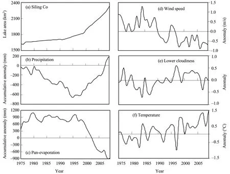
Figure 2 The time period of 1975-2009: (a) changes in area of Siling Co, which were deduced from TM images and previous reports (Chen et al., 2001; Bian et al., 2010), (b) annual precipitation, (c) annual pan-evaporation, (d) wind speed,(e) lower cloudiness, and (f) air temperature
An additional cause of lake expansion might be an increase in glacier meltwater drainage to the lake, as illustrated in Figure 1. Employing global glacier meltwater equations (Kotlyakov and Krenke, 1982), we estimated annual melting at equilibrium line altitude (ELA) on Geladandong Glacier (Figure 3). Results indicated that the meltwater at ELA on Geladandong Glacier has increased since 1976 in accordance with rising temperatures (Figure 2), and accumulated to a total of 9,790 mm w.e. (water equivalent) between 1976 and 2009.

Figure 3 Annual and accumulated meltwater at equilibrium line altitude (ELA) on Geladandong Glacier
4. Discussion
The water balance of a lake is governed by various water fluxes (e.g., on-lake precipitation, lake evaporation,surface runoff, groundwater) and these fluxes are controlled by many climatic and hydrologic processes. Precipitation is certainly an important source of water for Tibetan lakes, but other water fluxes and other climate variables can be equally important. For example, changes in air temperature and in ice cover can have a significant effect on lake evaporation (Hostetler 1991; Hostetler and Giorgi 1995; Qin and Huang 1998; Smallet al., 2001).The relative importance of these factors is as yet unknown.
(2)负反转构造对桩西潜山及上覆第三系的油气运聚和保存起到关键作用,控制并形成了研究区多层系、多类型的复式油气聚集带。
In Table 2 we elucidate lake changes in response to the climatic and glaciological changes shown in Figures 2 and 3. We summarized the periods between 1976-1994 and 1995-2009, and verified that a significant increase in lake area has occurred since 1995. We accounted for contributions of increased precipitation to changes in lake area by converting the amount of precipitation (mm)to lake drainage water. We determined the runoff coefficient by the method of Chenet al. (2009), who measured water levels of Namu Co during 2004-2008. We estimated the annual runoff coefficient to be 0.33 on a similar ground surface. We estimated lake surface water evaporation from pan-evaporation observed at Shenzha Station, and this was converted to lake surface area by using a ratio of 0.614, which was deduced for Qinghai Lake by Qu (1994). The glacier meltwater at ELA was treated as an average value of the entire glacier. Here, we assumed the meltwater was fed into the lake with no loss.
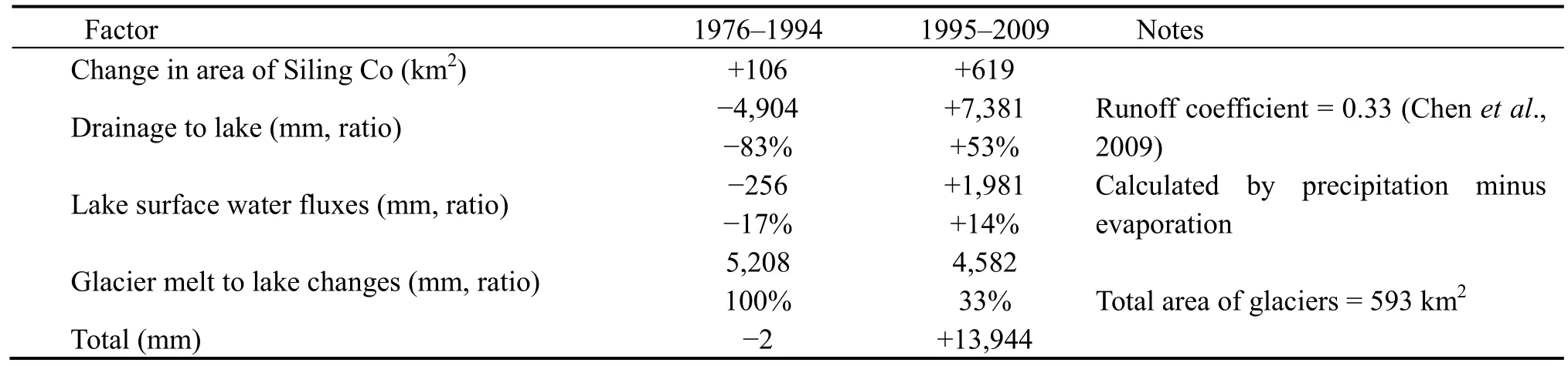
Table 2 Possible contributions of changes in precipitation, lake surface evaporation, and meltwater from the glacier
As shown in Table 2, 1976-1994 was a period of lake area stability, when decreases in precipitation and increases in water evaporation were balanced by large amounts of glacier meltwater, which accumulated to a total of 5,208 mm after drainage water was fed into the lake. During the period of significant lake expansion between 1995-2009, although contribution of glacier melt was decreased more than 600 mm in drainage wa-ter compared to the former period, increases in runoff and precipitation and decreases in water evaporation accounted for increases in drainage to the lake of 53%;lake surface water of 14%; and glacier melt of 33%.This might explain the expansion of the lake by 619 km2.
In summary, worsening climatic conditions (decreased precipitation and increased temperatures) that could have caused the lake to shrink during 1976-1994 were offset by increasing glacier meltwater feeding the lake, which made the lake nearly stable. This pattern changed during 1995-2009, when glacier meltwater actually decreased but participation runoff increased and evaporation decreased, leading to expansion of the lake. If balanced climatic conditions became suitable for further lake development, which would be indicated by an expansion of the lake area, the glacier meltwater could be saved in a stable reservoir.
This study was funded by the Major State Basic Research Development Program of China (973 Program)under Grant No. 2010CB951701 and by the Natural Science Foundation of China (No. 41071042), and was also supported by the Innovation Project of Chinese Academy of Sciences (KZCX2-YW-BR-22).
Bian D, Bian B, La B, Wang C, Chen T, 2010. The response of water level of Selin Co to climate change during 1975-2008. Acta Geographica Sinica, 65(3): 313-319.
Chen YF, Chen ZM, He DK, Cai B, Ba Z, 2001. Hydrographic features of Sêrling Co, North Tibetan Plateau. Journal of Lake Sciences,13(1): 21-28.
Chen F, Kang SC, Zhang YJ, You QL, 2009. Glaciers and lake change in response to climate change in the Namco Basin, Tibet. Journal of Mountain Science, 27(6): 641-647.
Hostetler SW, 1991. Simulation of lake ice and its effect on the late-Pleistocene evaporation rate of Lake Lahontan. Climate Dynamics, 6: 43-48.
Hostetler SW, Giorgi F, 1995. Effects of 2xCO2climate on two large lake systems: Pyramid Lake, Nevada and Yellowstone Lake, Wyoming. Global Planetary Change, 10: 43-54.
Intergovernmental Panel on Climate Change (IPCC), 2007. Climate Change 2007: The Scientific Basis. Cambridge University Press,UK.
Kang E, 2002. Glacier-Snow Water Resources and Mountain Runoff in the Arid Area of Northwest China. Science Press, Beijing. 55-71.
Khromova TE, Osipova GB, Tsvetkov DG, Dyurgerov MB, Barry RG,2006. Changes in glacier extent in the eastern Pamir, Central Asia,determined from historical data and ASTER imagery. Remote Sensing of Environment, 102(1-2): 24-32.
Kotlyakov VM, Krenke AN, 1982. Investigation of the hydrological condition of alpine regions by glaciological methods. IAHS, Publication, 138: 31-42.
Liu T, 1995. Changes of Yamzho Lake water stage in Xizang. Scientia Geographica Sinica, 15(1): 91-98.
Liu X, Chen B, 2000. Climatic warming in the Tibetan Plateau during recent decades. International Journal of Climatology, 20(14): 1729-1742.
Lu AX, Yao TD, Wang LH, Liu SY, Guo ZL, 2005. Study on the fluctuations of typical glaciers and lakes in the Tibetan Plateau using remote sensing. Journal of Glaciology and Geocryology, 27(6):783-792.
Qin B, Huang Q, 1998. Evaluation of the climatic change impacts on the inland lake: A case study of Lake Qinghai, China. Climatic Change, 39: 695-714.
Qu YG, 1994. Water balance and forecasting of water level change in Qinghai Lake. Journal of Lake Sciences, 6(4): 298-307.
Small EE, Filippo G, Sloan LC, Steven H, 2001. The effects of desiccation and climatic change on the hydrology of the Aral Sea. Journal of Climate, 14: 300-322.
Wang S, Dou H, 1998. Records of China Lakes. Science Press, Beijing.398-399.
Yao TD, Zhu LP, 2006. The response of environmental changes on Tibetan Plateau to global changes and adaptation strategy. Advanced Earth Sciences, 21: 459-464.
Yu G, Harrison SP, 1995. Holocene changes in atmospheric circulation patterns as shown by lake status changes in Northern Europe. Boreas, 24(3): 260-268.
10.3724/SP.J.1226.2011.00463
*Correspondence to: Dr. YinSheng Zhang, Key Laboratory of Tibetan Environment Changes and Land Surface Processes(TEL), Institute of Tibetan Plateau Research, Chinese Academy of Sciences. No. 18, Shuangqing Road, Beijing 100085,China. Email: yszhang@itpcas.ac.cn
12 June 2011 Accepted: 10 August 2011
猜你喜欢
杂志排行

Sciences in Cold and Arid Regions的其它文章
- Stress relaxation of warm frozen soil under drained or undrained conditions
- Research for length change of four seasons over China in recent 47 years
- Different characteristics of the structure of atmospheric boundary layer between dry and rainy periods overthe northern Tibetan Plateau
- Analysis on characteristics of aerosol absorption and scattering over Zhangye, China
- Characteristics of dynamic strain and strength of frozen silt under long-term dynamic loading
- Simulation and analysis of river runoff in typical cold regions